Local events in Dodson Township, Highland County
Nothing is posted for Dodson Township itself yet; here is what is on within 20 miles. All local events in Dodson Township, Highland County
Know a calendar we should watch? Send the link
Checked October 20; the events page is refreshed daily.
How Dodson Township, Highland County began
Dodson Township, in Highland County's northwest corner, was set off from Union, Salem and New Market townships on June 7, 1830 on a petition from Michael Stroup, and is named for Dodson Creek, which in turn recalls Joshua Dodson of Virginia, the first man to enter land on its banks in 1796 or 1797. Joseph Vanmeter raised the first cabin at the creek's mouth on the East Fork of the Little Miami in the spring of 1800, starting the Vanmeter settlement; a mile upstream, early settlers found bones, bullet-scarred trees and a carved beech marking where, by the 1890 county history's account (others place the fight elsewhere), in April 1792, Simon Kenton's Kentuckians attacked a large Native camp led by Tecumseh. Lynchburg grew on the river, was named by Virginians and incorporated in 1854, and Dodsonville was laid out in 1839; 1,975 people lived in the township in 1900, and 2,598 in 2020, including part of Lynchburg.
Settled 1800 (Joseph Vanmeter, at the mouth of Dodson Creek), incorporated 1830-06-07 (township set off from Union, Salem and New Market on petition of Michael Stroup), by Joseph Vanmeter (first settler, 1800); Peter Vanmeter (fall 1800); Anthony Stroup (1806); Michael Stroup (petitioner for the township).
Where the name comes from
Dodson Township took its name from Dodson Creek. Klise's 1902 county history says the creek preserves the name of Joshua Dodson of Virginia, who located large tracts of land near its mouth soon after the Treaty of Greenville; Scott's history (compiled 1890) says he made the first entry of land on its banks as early as 1796 or 1797, just east of the present town of Dodsonville. Wikipedia instead calls him a government surveyor, which neither county history says.
Before the town
The 1890 history of early Highland County describes the one recorded battle of the township's ground. In April 1792, after Indian raiders again crossed the Ohio into Kentucky, Simon Kenton raised 37 men, followed the trail to the East Fork of the Little Miami, shot an Indian horseman whose pony wore a bell, and at midnight attacked a large Native camp of tents and marquees (some thought taken at St. Clair's defeat), which Tecumseh commanded and which Kenton's informant Riddle numbered at about two hundred, including women. Kenton retreated after a few minutes; John Barr was killed by Tecumseh with a war club, and the Native force reportedly lost about thirty. The 1890 history locates the camp 'a short distance above the residence of Michael Stroup', on the William Gibler farm about a mile above the mouth of Dodson Creek, on the southeast bank of the East Fork near a yellow bank and a ten-acre prairie, citing human bones, bullet-scarred trees, camp-fire marks, a tomahawk and a gun barrel found there, and a beech carved with a war-costumed figure and tally notches. It also notes others place the fight nearer Williamsburg and that McClung's Western Adventures tells it differently. The township lies within the 1795 Treaty of Greenville cession.
Nations recorded here: Shawnee.
- Kenton-Tecumseh battle ground on the East Fork (battle) — Gibler farm, about a mile above the mouth of Dodson Creek, southeast bank of the East Fork of the Little Miami, near Michael Stroup's farm (location disputed; some place it near Williamsburg), April 1792 (archive.org)
Timeline
- — Simon Kenton and 37 Kentuckians attack Tecumseh's large encampment on the East Fork of the Little Miami at midnight, as the 1890 county history places it, near Michael Stroup's farm and a mile above Dodson Creek; John Barr is killed and the party retreats; a scout named McIntire is later captured and killed.
- — Joshua Dodson of Virginia makes the first entry of land on Dodson Creek, 1796 or 1797, just east of the later Dodsonville.
- — Joseph Vanmeter moves from Kentucky and builds a cabin at the mouth of Dodson Creek in spring, with neighbors from the Deerfield settlement on the Miami raising it; his brother Peter settles nearby that fall, and Vanmeter's house, called the Vanmeter Stand, entertains travelers.
- — Highland County, including the land that became Dodson Township, is organized from parts of Ross, Adams, and Clermont counties.
- — Anthony Stroup buys land southeast of Vanmeter and moves on it; William Spickard, David Hays and William Smith settle near the present Lynchburg, and the Vanmeter settlement grows with its first log school (taught by William Knox) and Baptist and Methodist meetings.
- — Lynchburg is platted on the East Fork of the Little Miami River at the Dodson Township line, named for Lynchburg, Virginia, the birthplace of one of its first settlers.
- — The county commissioners set off Dodson Township on June 7 from Union, Salem and New Market townships on the petition of Michael Stroup.
- — Lynchburg is laid out on the East Fork, named by settlers from the Lynchburg, Virginia area (the Hundleys, Dudleys and Botts); an early list gives 1830 for its laying out by Andrew Smith and Coleman Botts.
- — Dodsonville is laid out by Daniel Shafer and L. L. Cartwright.
- — The Marietta railroad, surveyed through Lynchburg in 1851, is completed to that point, reaching Hillsboro the next year; a distillery is built at Lynchburg in 1857 by Berryhill & Bowen, later owned by Freiberg & Workum.
- — The village of Lynchburg is incorporated, with Sinclair Liggett its first mayor.
- — Dodson Township, including Lynchburg, has 1,975 inhabitants in the census (Lynchburg alone 907).
- — Dodson Township has 2,598 residents in the 2020 census, including the part of the village of Lynchburg that lies in the township.
Stories
A township with only one namesake in Ohio
When Highland County's northwest corner was organized into a township in 1830, it took the name of Dodson Creek, which Klise's county history says recalls Joshua Dodson of Virginia, an early landholder near its mouth. Wikipedia says it is the only Dodson Township in Ohio. The township sits on the Clinton County border, drained by tributaries of the East Fork of the Little Miami River, with the village of Lynchburg on its northern edge.
A village on the county line
Lynchburg was laid out in the early 1830s on the East Fork of the Little Miami, where a gristmill and sawmill once ran on the river's power, and named for Lynchburg, Virginia, the birthplace of an early settler. The village grew up straddling the Highland-Clinton county line, and part of it sits inside Dodson Township's northern edge while the rest lies in Clinton County townships across the river. The old mill site on the East Fork later became the location of the Lynchburg Covered Bridge, built in 1870 and rebuilt after storm damage in 1974 — reportedly Ohio's only covered bridge to span a county line.
Kenton meets Tecumseh on the East Fork
In April 1792, with the settlers of northern Kentucky in constant dread of Shawnee raiders, Simon Kenton took 37 men across the Ohio near Limestone (Maysville) and followed a marauding party's trail toward the head of the Little Miami. Near the East Fork they heard a bell, and his scout Cornelius Washburn shot an Indian riding a pony. Scouting ahead at dusk, Kenton found a camp of tents and marquees, possibly taken at St. Clair's defeat, on the bank of the East Fork. At midnight his men crept within a few feet of the tents and fired into them at once, but the camp numbered perhaps two hundred, a white man living with them named Riddle later told Kentuckians, and a second line of tents lay unseen across the creek. Tecumseh, lying by his fire, sprang up and killed John Barr with a war club; Kenton ordered a retreat, and his party spent three days getting back to Limestone, two without food. The Kentuckians left behind a scout named McIntire, whom Tecumseh's men overtook; settlers later found his bones hanging in trees. Joseph Vanmeter, who built his cabin at Dodson Creek some years afterward, buried them.
Vanmeter Stand
Joseph Vanmeter left Kentucky in the spring of 1800 and built a cabin at the mouth of Dodson Creek, a few rods east of the house where Michael Stroup later lived. Men from the Deerfield settlement on the Miami came to help raise it. He cleared the first field for many miles around, sold his brother Peter 50 acres for a nominal price to get a neighbor, and kept entertainment for travelers in a house known far and wide as the Vanmeter Stand. Anthony Stroup bought the adjoining land in 1806. The settlers lived on wild meat and hominy, ground at hand mills because the nearest mill was at Deerfield or on the Scioto; bear, deer, panther, wildcat and wolves filled the woods. The first school, built of round logs north of the creek, was taught by William Knox; the first marriage was John Vanmeter to Margaret, Joseph's daughter, and their daughter was the first birth in the settlement.
Photographs
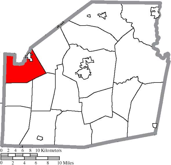
Photo: Ruhrfisch and Nyttend, Wikimedia Commons, CC BY-SA 3.0 · Wikimedia Commons
Local history sources: en.wikipedia.org · en.wikipedia.org · en.wikipedia.org · en.wikipedia.org · en.wikipedia.org · en.wikipedia.org · dn721504.ca.archive.org · geonames.org · commons.wikimedia.org · commons.wikimedia.org · archive.org · archive.org
Water
Mostly private wells The water here
- Lynchburg Village84% of residentsGroundwater wells (3 wells)
- Hillsboro City12% of residentsClear Creek (via Selph Road & Liberty Park Reservoirs)
- Highland County Water Company, Inc.4% of residentsSand-and-gravel aquifer wells (Ross/Highland Co. well fields; local wells)
Hospitals, fire stations and more
Inside Dodson Township, Highland County's boundary: 1 health center, 1 fire or EMS station, 3 public schools, 1 poor-rated bridge and 2 spill cases. Press a pin or a name for its whole record and its source.
Community health centers (1)
-
Highland Health Providers - Lynchburg Medical CenterHealth center · Lynchburg
- Run by
- a federally qualified health center
- Setting
- Clinic
- City
- Lynchburg
- Coordinates
- 39.25273, -83.78828
Find a Health Center (HRSA) ↗ HRSA data (source) ↗ Street map and directions ↗
Source: HRSA health center service delivery sites, active, September 2026 (school-based sites left out). Health centers see patients whether or not they have insurance, with fees on a sliding scale.
Fire and EMS stations (1)
-
Lynchburg Fire Department and Ambulance DistrictLynchburg
- Address
- 8123 State Highway 135, Lynchburg, OH 45142
- Coordinates
- 39.23196, -83.78948
USGS National Map structures (source) ↗ Street map and directions ↗
Source: USGS National Map structures (most Ohio records last updated 2019 to 2022), checked against the Columbus and Cleveland station lists. The department that answers a call is set by jurisdiction and mutual aid, not by distance.
Public schools (3)
-
Lynchburg-Clay Elementary School4.5 of 5 stars · Lynchburg
- Address
- 6760 State Route 134, Lynchburg, OH 45142
- School district
- Lynchburg-Clay Local School District
- Kind (NCES)
- Regular School
- Students, 2023-24
- 502
- Teachers (full-time equivalent)
- 35
- Report card, 2025-26
- 4.5 of 5 stars
- Performance index
- 86.3%
- Ohio building IRN
- 139212
- NCES school ID
- 390476303584
NCES school record ↗ Ohio School Report Card ↗ Street map and directions ↗
-
Lynchburg-Clay High School3.5 of 5 stars · Lynchburg
- Address
- 6762 State Route 134, Lynchburg, OH 45142
- School district
- Lynchburg-Clay Local School District
- Kind (NCES)
- Regular School
- Students, 2023-24
- 279
- Teachers (full-time equivalent)
- 23.5
- Report card, 2025-26
- 3.5 of 5 stars
- Performance index
- 77.3%
- Four-year graduation rate
- 100%
- Ohio building IRN
- 021816
- NCES school ID
- 390476302933
NCES school record ↗ Ohio School Report Card ↗ Street map and directions ↗
-
Lynchburg-Clay Middle School3 of 5 stars · Lynchburg
- Address
- 8250 State Route 134, Lynchburg, OH 45142
- School district
- Lynchburg-Clay Local School District
- Kind (NCES)
- Regular School
- Students, 2023-24
- 238
- Teachers (full-time equivalent)
- 21
- Report card, 2025-26
- 3 of 5 stars
- Performance index
- 76.8%
- Ohio building IRN
- 139220
- NCES school ID
- 390476303595
NCES school record ↗ Ohio School Report Card ↗ Street map and directions ↗
Source: NCES EDGE public school locations 2024-25 and Common Core of Data 2023-24 (type, students, teachers); Ohio School Report Cards 2025-26 (Department of Education and Workforce), matched by name within the district.
Bridges rated poor (1)
-
Gibler Rd #118 over Dodson CreekPoor · built 1950
- Condition
- Poor: a deck, superstructure, substructure or culvert rated 4 or below on the 0 to 9 scale
- What it is
- Bridge
- Built
- 1950
- Length
- 19 ft
- Owner
- County
- Vehicles a day
- 28
- Coordinates
- 39.19764, -83.74951
National Bridge Inventory (source) ↗ Street map and directions ↗
Source: FHWA National Bridge Inventory 2025. "Poor" means one major part rated 4 or below on the 0 to 9 scale; it calls for repair, not closing, unless the state posts or closes the bridge.
Spills reported since 2021 (2)
-
Fuel Diesel / Diesel Fuel (Vehicle On Or Off Road)2025-06-18 · Dodson Twp
- Reported
- 2025-06-18
- What spilled
- Fuel Diesel / Diesel Fuel (Vehicle On Or Off Road)
- Largest amount reported
- 38 gallons
- Where
- Dodson Twp, Highland County
- Ohio EPA district office
- SWDO
- Ohio EPA case number
- 2506EPA0001005
Ohio EPA spill reports (source) ↗ Street map and directions ↗
-
Fish Kill2024-06-17 · Dodson Twp
- Reported
- 2024-06-17
- What spilled
- Fish Kill
- Where
- Dodson Twp, Highland County
- Ohio EPA district office
- SWDO
- Ohio EPA case number
- 2406EPA0001017
Ohio EPA spill reports (source) ↗ Street map and directions ↗
Source: Ohio EPA emergency response spill reports, 2021 to September 2026, one point per case where Ohio EPA placed it. A report is what the caller or responder recorded; amounts are often blank or estimated.
Its ZIP codes
Each ZIP code that touches Dodson Township, Highland County, with the share of its residents who live here and the same headline figures as the ZIP page.
| ZIP | Share | Water | Radon | Home value | Schools | Flood |
|---|---|---|---|---|---|---|
| 45142 Lynchburg | 23% | Mostly private wells | 4.0 pCi/L average radon | Appraisal records without year built | Lynchburg-Clay Local · 4 stars overall | 1.7% of residents in the 1% floodplain |
| 45133 Hillsboro | 1% | Mostly private wells | 4.2 pCi/L average radon | Appraisal records without year built | Hillsboro City · 3.5 stars overall | 0.2% of residents in the 1% floodplain |
Local government
Who holds office in Dodson Township, Highland County, how its elections and ballot issues came out, and the state auditor's record.
Money issues on the ballot since 2023: 1 of 1 passed.
Ballot issues
| Date | Issue | For | Against | Result |
|---|---|---|---|---|
| 2023-11-07 | Issue 5: Dodson Township Renewal | 230 | 115 | Passed (66.67% for) |
Elections for office
| Date | Office | Candidates and votes |
|---|---|---|
| 2023-11-07 | Trustee | Marvin Resibois 700, 100.0% |
| 2023-11-07 | Fiscal Officer | Kristy Warner 665, 100.0% |
| 2021-11-02 | Township Trustee (unofficial count) | Ty Smith 273, 42.79%; Randy Mitchell 261, 40.91%; Greg Tholen 104, 16.3% |
| 2019-11-05 | Trustee | Marvin Resibois 381, 100.0% |
| 2019-11-05 | Fiscal Officer | Kristy Warner 366, 100.0% |
Winners in bold. Results from the county board of elections' official canvass unless marked.
Auditor of State record
- No fiscal caution, watch or emergency on the Auditor of State's lists.
- Basic Audit, 2024 to 2025, released 2026-09-08
The county
Highland County: 7 ZIP codes, 26 cities, villages and townships, 42,302 people.
Nearby places
Quick answers
What county is Dodson Township, Ohio in?
Dodson Township, Highland County is a township in Highland County, Ohio, with 1,203 residents.
When was Dodson Township, Ohio founded?
Dodson Township, Highland County was settled 1800 (Joseph Vanmeter, at the mouth of Dodson Creek); incorporated 1830-06-07 (township set off from Union, Salem and New Market on petition of Michael Stroup). Founders on record: Joseph Vanmeter (first settler, 1800); Peter Vanmeter (fall 1800); Anthony Stroup (1806); Michael Stroup (petitioner for the township). Source
How did Dodson Township, Ohio get its name?
Dodson Township took its name from Dodson Creek. Source
What ZIP code is Dodson Township, Ohio?
Most of Dodson Township, Highland County is in ZIP code 45142.
Where does Dodson Township, Ohio get its water?
The main water source for Dodson Township, Highland County (Lynchburg Village): Mostly private wells.
Cite this page
Cite this page as:
Cracked Buckeye, "Dodson Township, Highland County", https://crackedbuckeye.com/place/dodson-township-highland-county/, built 2026-10-31, accessed [date].
How to cite · Report a correction · Built 2026-10-31
