Local events in Lynchburg
Nothing is posted for Lynchburg itself yet; here is what is on within 20 miles. All local events in Lynchburg
Know a calendar we should watch? Send the link
Checked October 20; the events page is refreshed daily.
How Lynchburg began
Lynchburg sits astride the Highland-Clinton county line on the East Fork of the Little Miami River, a site that was still a Shawnee encampment under Tecumseh when Kentucky rangers fought Highland County's worst recorded battle with Native Americans there in 1792. Coleman Botts and Andrew Smith platted the village in 1830 and named it, by the best-documented account, for Lynchburg, Virginia, the home of an early settler. It grew through the 19th century around milling and, after 1855, a whiskey distillery that by 1910 was one of the region's largest, and it is now the site of Ohio's only wooden covered bridge connecting two counties.
Platted 1830, by Coleman Botts and Andrew Smith.
Where the name comes from
Two accounts survive: one holds that Lynchburg was named for a defeat suffered by settlers at the hands of Native Americans in 1792; the other, generally favored, holds that many of the village's settlers came from Lynchburg, Virginia, and named their new town after their former home.
Before the town
The site of Lynchburg was occupied by a large Shawnee encampment under Tecumseh's leadership until about 1806. In 1792, a mounted party of Kentuckians led by Simon Kenton, pursuing Native raiders who had crossed into Kentucky, burned cabins and stolen horses, reached the encampment near the future village and found themselves outnumbered; in the fighting that followed — remembered as Highland County's worst battle between Indians and settlers — Alexander McIntyre was killed, and scarred, notched trees and the remains of campfires and weapons reportedly marked the site for years afterward. The land had passed out of Native ownership at the Treaty of Greenville (1795), signed by the Shawnee, Wyandot, Lenape (Delaware), Miami, Ottawa and other nations, three years after this fight.
Nations recorded here: Shawnee.
- Lynchburg site (Tecumseh's encampment and the 1792 battle) (camp|battle) — at or near the present village of Lynchburg, on the East Fork of the Little Miami River, occupied until c. 1806; battle in 1792 (timesgazette.com)
Timeline
- — Simon Kenton leads a mounted party of Kentuckians to the Shawnee encampment on the future Lynchburg site in pursuit of raiders; outnumbered, the Kentuckians are attacked and Alexander McIntyre is killed in what is remembered as Highland County's worst fight between Indians and settlers.
- — About this year, the Shawnee encampment under Tecumseh that had occupied the Lynchburg site is given up.
- — Coleman Botts and Andrew Smith plat the village of Lynchburg.
- — John Bowen, from the Pricetown area, begins building a distillery at Lynchburg; it grows over the next 60 years into the Freiberg and Workum (F&W) whiskey distillery.
- — Builder John C. Gregg completes the Lynchburg covered bridge over the East Fork of the Little Miami River for $3,138.66, connecting Highland and Clinton counties.
- — The village's population is recorded at 476.
- — The F&W distillery at Lynchburg is processing 3,000 bushels a day with storage for more than 100,000 barrels, employing coopers, engineers and bottlers.
- — The Lynchburg covered bridge faces removal but is preserved after community advocacy.
- — March 16: the Lynchburg Covered Bridge is listed on the National Register of Historic Places.
- — The census records 1,205 residents.
- — The Lynchburg covered bridge is renovated and rededicated at Ruth Cramton Memorial Park.
Stories
The fight at Tecumseh's camp
Before there was a village, the ground where Lynchburg now stands held a large Shawnee encampment on the East Fork of the Little Miami, and its leader for a time was a young Tecumseh. In 1792, Kentucky raiders had crossed the Ohio River, burned settler cabins and run off horses; a mounted company of Kentuckians under the frontiersman Simon Kenton rode north in pursuit and came upon the encampment near the future townsite. They found the force there far larger than they expected and were driven back in the fighting that followed. Alexander McIntyre was killed, and for years afterward travelers reported scarred and notched trees and the burned-out remains of campfires and weapons marking the ground. It stands as the worst recorded clash between Native Americans and settlers in Highland County's history, and it happened on the same low ground where, thirty-eight years later, Coleman Botts and Andrew Smith platted a peaceable milling village and named it for a town in Virginia.
A covered bridge between two counties
In December 1870, bridge builder John C. Gregg finished a wooden covered bridge over the East Fork of the Little Miami River at Lynchburg for $3,138.66, built to carry traffic across the river that also marks the Highland-Clinton county line. It is Ohio's only surviving covered bridge that connects two counties. The bridge nearly came down in 1963, when county officials weighed replacing it, but local advocacy kept it standing, and it underwent a full renovation in 2023, marked with a rededication ceremony at the village's Ruth Cramton Memorial Park.
Photographs
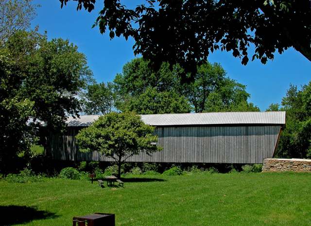
Photo: dok1, via Wikimedia Commons, CC BY 2.0 · Wikimedia Commons
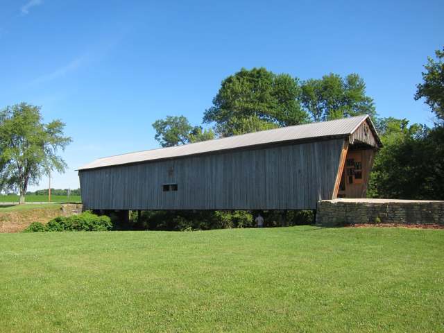
Photo: Art Anderson, via Wikimedia Commons (Panoramio), CC BY-SA 3.0 · Wikimedia Commons
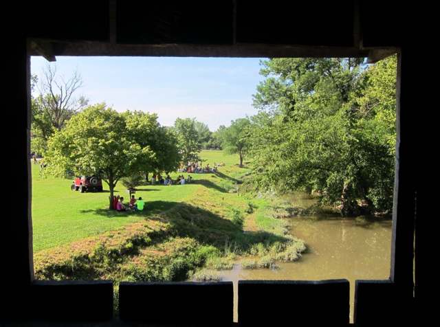
Photo: Art Anderson, via Wikimedia Commons (Panoramio), CC BY-SA 3.0 · Wikimedia Commons
Local history sources: en.wikipedia.org · visithighlandcounty.com · timesgazette.com · en.wikipedia.org · en.wikipedia.org · commons.wikimedia.org · commons.wikimedia.org · commons.wikimedia.org
Historic places
1 place in Lynchburg on the National Register of Historic Places. Press a pin or a name for its whole record.
-
Lynchburg Covered BridgeStructure · Lynchburg · listed 1976
- Address
- East Fork of Little Miami River
- Where
- Lynchburg, Highland County · ZIP 45142
- What it is
- Structure
- Listed on the National Register
- 1976
- NRIS reference number
- 76001456
- Coordinates
- 39.24507, -83.79443
National Register file (NPS) ↗ Search Wikipedia ↗ Street map and directions ↗ On the Cracked Buckeye map
Source: National Park Service, National Register of Historic Places point file. The listing year is shown where NPS's certification date agrees with the listing's reference number. Listing recognizes significance; it does not restrict a private owner.
Water
Mostly private wells The water here
- Lynchburg Village100% of residentsGroundwater wells (3 wells)
Hospitals, fire stations and more
Inside Lynchburg's boundary: 1 library, 1 police station and 2 spill cases. Press a pin or a name for its whole record and its source.
Public libraries (1)
-
Lynchburg BranchBranch · Lynchburg
- Address
- 102 S. Main, Lynchburg, OH 45142
- What it is
- Branch
- Library system
- Highland County District Library
- Open
- 2,288 hours a year, 52 weeks
- Building
- 4,000 sq ft
- System's visits, FY2024
- 115,752
- System's loans, FY2024
- 258,208
- People the system serves
- 42,139
- Phone
- (937) 364-2511
IMLS Public Libraries Survey (source) ↗ Street map and directions ↗
Source: IMLS Public Libraries Survey FY2024 (outlets and their systems). Any Ohio resident can get a free card at any Ohio public library.
Police stations (1)
-
Lynchburg Police DepartmentLynchburg
- Address
- 155 South Main Street, Lynchburg, OH 45142
- Coordinates
- 39.24256, -83.79265
USGS National Map structures (source) ↗ Street map and directions ↗
Source: USGS National Map structures, police stations, corrected and completed by hand (September 2026). The department that answers a call is set by jurisdiction, not by distance.
Spills reported since 2021 (2)
-
Oil Motor / Lube Oil / Vehicle2021-09-27 · Lynchburg
- Reported
- 2021-09-27
- What spilled
- Oil Motor / Lube Oil / Vehicle
- Largest amount reported
- 4 gallons
- Where
- Lynchburg, Highland County
- Ohio EPA district office
- SWDO
- Ohio EPA case number
- 2109EPA0001527
Ohio EPA spill reports (source) ↗ Street map and directions ↗
-
Sediment / Sedimentation2026-04-23 · Lynchburg
- Reported
- 2026-04-23
- What spilled
- Sediment / Sedimentation
- Where
- Lynchburg, Highland County
- Ohio EPA district office
- SWDO
- Ohio EPA case number
- 2604EPA0000680
Ohio EPA spill reports (source) ↗ Street map and directions ↗
Source: Ohio EPA emergency response spill reports, 2021 to September 2026, one point per case where Ohio EPA placed it. A report is what the caller or responder recorded; amounts are often blank or estimated.
Its ZIP codes
Each ZIP code that touches Lynchburg, with the share of its residents who live here and the same headline figures as the ZIP page.
| ZIP | Share | Water | Radon | Home value | Schools | Flood |
|---|---|---|---|---|---|---|
| 45142 Lynchburg | 32% | Mostly private wells | 4.0 pCi/L average radon | Appraisal records without year built | Lynchburg-Clay Local · 4 stars overall | 1.7% of residents in the 1% floodplain |
Local government
Who holds office in Lynchburg, how its elections and ballot issues came out, and the state auditor's record.
Money issues on the ballot since 2021: 5 of 5 passed.
Ballot issues
| Date | Issue | For | Against | Result |
|---|---|---|---|---|
| 2023-11-07 | Issue 12: Village of Lynchburg Renewal | 284 | 181 | Passed (61.08% for) |
| 2022-11-08 | Issue: Lynchburg Street Levy 5 mills (5.0 mills) | 1 | 0 | Passed (100.0% for) |
| 2022-11-08 | Issue: Lynchburg Operating Levy 1 mill (1.0 mills) | 1 | 0 | Passed (100.0% for) |
| 2021-11-02 | Issue: Lynchburg Police Levy | 1 | 0 | Passed (100.0% for) |
| 2021-11-02 | Issue: Lynchburg Village Renewal | 136 | 61 | Passed (69.04% for), unofficial |
Elections for office
| Date | Office | Candidates and votes |
|---|---|---|
| 2023-11-07 | Member of Council | Marty Bailey 321, 57.42%; Chris Toller 238, 42.58% |
| 2023-11-07 | Mayor | Terry Burden 199, 42.7%; James Burton 267, 57.3% |
| 2021-11-02 | Member of Council | Judy Lee Davis 1, 25.0%; Christine Hamlin 1, 25.0%; David Minton 1, 25.0%; Tagg J. Pendleton 1, 25.0% |
| 2021-11-02 | Member of Council (unofficial count) | David Minton 142, 29.58%; Judy Lee Davis 117, 24.38%; Christine Hamlin 112, 23.33%; Tagg J. Pendleton 109, 22.71% |
| 2019-11-05 | Member of Council | Marty Bailey 171, 53.94%; Ken Eaglin 146, 46.06% |
| 2019-11-05 | Mayor | James A. Burton 188, 100.0% |
Winners in bold. Results from the county board of elections' official canvass unless marked.
Auditor of State record
- Fiscal emergency: declared 1988-04-19, released 1995-10-17. source
- Agreed Upon Procedures, 2023 to 2024, released 2025-09-02
The county
Highland County: 7 ZIP codes, 26 cities, villages and townships, 42,302 people.
Nearby places
Rain and snow
How much has actually fallen on Lynchburg, day by day, from 1893 to now. Daily totals, not averages.
- rain, last 30 days
- 0.91 in
- 2026-09-30 to 2026-10-29
- rain so far in 2026
- 43.4 in
- 5.3 in above normal for the date
- snow so far in 2026
- 18.0 in
- a normal year brings 21.1 in
- a normal year
- 45.0 in
- average of 30 years, 1991-2020
| Month | Rain (in) | Snow (in) | Days counted |
|---|---|---|---|
| October 2026 | 0.91 | — | 29 |
| September 2026 | 7.18 | — | 30 |
| August 2026 | 6.51 | — | 31 |
| July 2026 | 3.63 | — | 31 |
| June 2026 | 5.67 | — | 30 |
| May 2026 | 5.14 | — | 31 |
| April 2026 | 4.29 | — | 30 |
| March 2026 | 7.42 | 0.8 | 31 |
| February 2026 | 1.14 | 6.2 | 28 |
| January 2026 | 1.51 | 10.9 | 31 |
| December 2025 | 2.85 | 11.2 | 31 |
| November 2025 | 3.85 | 3.5 | 30 |
| Wettest year | 2011 — 60.3 in |
|---|---|
| Driest year | 1901 — 23.8 in |
| Snowiest year | 1910 — 54.2 in |
| Wettest day on record | 5 March 1963 — 4.42 in |
| Heaviest snowfall in a day | 6 January 1910 — 12.01 in |
| Deepest snow on the ground | 21 January 1978 — 25.05 in |
Estimated, not measured. No rain gauge has ever stood inside Lynchburg, so every figure here is worked out from the gauges around it - the nearest ones weighted most. Treat them as close estimates rather than readings.
48,522 days of records, 1893-01-01 to 2026-10-29. Source: NOAA NCEI GHCN-Daily, 3,240 gauges in and around Ohio. A day is "gauged" when a gauge standing inside the boundary reported it, and the value is the mean of those gauges. Otherwise it is interpolated by inverse distance from every gauge reporting within 50 miles. Nothing is carried forward, back-filled or smoothed. Against NOAA nClimDiv county monthly precipitation over 136,848 complete county-months (checked 2026-10-31): correlation 0.9515, median absolute difference 0.217 in a month. Built 2026-10-31 from the Cracked Buckeye precipitation archive. Snow is the softer number — snowfall is measured by hand with a ruler, no agency publishes a gridded county snowfall series, and blowing snow defeats every observer.
Environmental permits and filings
What Ohio EPA has on file for Lynchburg: permits, inspections, violations, cleanups and the state loans behind sewer and water work. Every line links to the agency's own document.
- facilities and sites on file
- 5
- those placed on the map inside Lynchburg
| Program | Facilities and sites |
|---|---|
| Wastewater and stormwater discharge | 3 |
| Public drinking water | 1 |
| State sewer loans | 1 |
| Date | Facility or site | What |
|---|---|---|
| LYNCHBURG VILLAGE PWS | Public drinking water compliance letter | |
| LYNCHBURG VILLAGE PWS | Public drinking water compliance letter | |
| LYNCHBURG VILLAGE PWS | Public drinking water report | |
| LYNCHBURG VILLAGE PWS | Public drinking water plan | |
| LYNCHBURG VILLAGE PWS | Public drinking water inspection | |
| RUTH CRAMPTON PARK IMPROVEMENTS | Wastewater and stormwater discharge permit | |
| LYNCHBURG VILLAGE PWS | Public drinking water inspection | |
| LYNCHBURG VILLAGE PWS | Public drinking water inspection | |
| RUTH CRAMTON PARK IMPROVEMENTS | Wastewater and stormwater discharge permit | |
| LYNCHBURG VILLAGE PWS | Public drinking water compliance letter | |
| LYNCHBURG VILLAGE PWS | Public drinking water report | |
| MIRAC LLC | Wastewater and stormwater discharge inspection | |
| LYNCHBURG VILLAGE PWS | Public drinking water compliance letter | |
| LYNCHBURG VILLAGE PWS | Public drinking water inspection | |
| LYNCHBURG VILLAGE PWS | Public drinking water report | |
| LYNCHBURG VILLAGE PWS | Public drinking water inspection | |
| LYNCHBURG VILLAGE PWS | Public drinking water violation resolved | |
| LYNCHBURG VILLAGE PWS | Public drinking water compliance letter | |
| LYNCHBURG VILLAGE PWS | Public drinking water permit | |
| LYNCHBURG VILLAGE PWS | Public drinking water notice of violation | |
| LYNCHBURG VILLAGE PWS | Public drinking water notice of violation | |
| LYNCHBURG VILLAGE PWS | Public drinking water report | |
| LYNCHBURG VILLAGE PWS | Public drinking water notice of violation | |
| LYNCHBURG VILLAGE PWS | Public drinking water violation resolved | |
| LYNCHBURG VILLAGE PWS | Public drinking water plan |
Source: Ohio EPA eDocument portal (edocpub.epa.ohio.gov), indexed 2026-10-14. Facilities are placed on the map from Ohio EPA's own map layers, EPA's Facility Registry, coordinates written in the filings, or a geocoded street address. A permit filed under a private person's name (most are household septic systems) is counted but never named, placed or linked; licenses for individual workers and open-burning notices are left out entirely.
Quick answers
What county is Lynchburg, Ohio in?
Lynchburg is a village in Highland County, Ohio, with 1,406 residents.
When was Lynchburg, Ohio founded?
Lynchburg was laid out 1830. Founders on record: Coleman Botts and Andrew Smith. Source
How did Lynchburg, Ohio get its name?
Two accounts survive: one holds that Lynchburg was named for a defeat suffered by settlers at the hands of Native Americans in 1792; the other, generally favored, holds that many of the village's settlers came from Lynchburg, Virginia, and named their new town after their former home. Source
What ZIP code is Lynchburg, Ohio?
Most of Lynchburg is in ZIP code 45142.
Where does Lynchburg, Ohio get its water?
The main water source for Lynchburg (Lynchburg Village): Mostly private wells.
Cite this page
Cite this page as:
Cracked Buckeye, "Lynchburg, Highland County", https://crackedbuckeye.com/place/lynchburg/, built 2026-10-31, accessed [date].
How to cite · Report a correction · Built 2026-10-31
