Local events in Bath Township, Greene County
Nothing is posted for Bath Township itself yet; here is what is on within 10 miles. All local events in Bath Township, Greene County
Know a calendar we should watch? Send the link
Checked October 20; the events page is refreshed daily.
Deep dives about Bath Township, Greene County
Long reads built from maps, newspapers and public records. All deep dives
- Dayton Aviation Heritage National Historical ParkCreated by Congress in 1992, the park preserves the Wright brothers' Dayton sites, from their 1890s print and cycle shops to Huffman Prairie, where they flew in 1904-05.
- National Museum of the U.S. Air ForceThe Air Force museum began in 1923 in a McCook Field hangar corner and opened to the public in 1955. It now holds more than 360 aircraft and missiles near Dayton.
How Bath Township, Greene County began
Bath Township, in Greene County's northwest corner, was organized in 1807 and named for Bath, Maine, itself named after Bath, England, because one of its early settlers had come from the Maine city. The Mercer family of Virginia were its first settlers, farming there before 1799; their log house still stands and is listed on the National Register of Historic Places. The township's oldest village, Fairfield, stalled in the mid-1800s after its landowners refused to let a railroad cut across their farms, and the rail town of Osborn grew up nearby instead. In the 20th century the township was transformed by aviation and the military: the Wright brothers tested their aircraft at Huffman Prairie on township land, and most of what became Wright-Patterson Air Force Base, along with most of the city of Fairborn, now sits inside Bath Township's boundaries.
Settled before 1799 (Mercer family, from Virginia), incorporated 1807 (township organized), by Greene County's early township organization; first settled by the Mercer family.
Where the name comes from
Bath Township was named for Bath, Maine, because one of its early settlers had come from that city; Bath, Maine was in turn named for Bath, England.
Before the town
An Adena burial mound survives on Wright-Patterson Air Force Base land in the township, about 0.62 miles south of the Wright Brothers Memorial on Huffman Prairie: it is roughly 86 feet across and just over 8 feet tall, sits on a bluff, and has never been excavated, though a 1996 geophysical survey examined it without disturbing the earth. It was added to the National Register of Historic Places in 1972 as the fourth Greene County listing. Beyond that mound, no specific Shawnee or other historic-nation village, trail, or camp is documented as sitting inside Bath Township itself; secondary sources describe Shawnee people living across the wider Mad River valley and Greene County, with recorded raids and prisoner exchanges but no massacres, and the nearest well-documented historic Shawnee towns (such as Old Chillicothe, later called Old Town) lie elsewhere in Greene County.
Nations recorded here: Shawnee, Adena culture.
- Wright-Patterson Air Force Base Mound (mound) — Wright-Patterson AFB, about 0.62 miles south of the Wright Brothers Memorial on Huffman Prairie, Bath Township, Adena culture, c. 500 BC - AD 400 (en.wikipedia.org)
Timeline
- — The Mercer family, immigrants from Virginia, are farming in Bath Township; the exact date of their arrival is not recorded, but crops were being raised before George Washington's death in 1799.
- — Fairfield, the township's oldest village, is settled with its first log cabin.
- — Bath Township is formally organized as one of Greene County's original townships, in the county's northwest corner.
- — When the Big Four Railroad is routed northeast from Dayton toward Springfield, Fairfield's residents and neighboring farmers block it from passing through the village because the diagonal route would cut through their farms; the railroad instead runs through what becomes Osborn.
- — Wilbur and Orville Wright test-fly their aircraft roughly 150 times at Huffman Prairie, on township land near the Simms Station interurban stop, developing the Wright Flyer III.
- — The U.S. Army Signal Corps establishes Wilbur Wright Field on the Huffman Prairie site.
- — Wright Field and neighboring Patterson Field merge to form Wright-Patterson Air Force Base, most of which lies within Bath Township.
- — The Adena burial mound on Wright-Patterson AFB land, south of the Wright Brothers Memorial, is added to the National Register of Historic Places.
- — Huffman Prairie Flying Field is designated a National Historic Landmark as part of what becomes the Dayton Aviation Heritage National Historical Park.
Stories
The railroad the farmers turned away
When railroad surveyors laid out a route from Dayton to Springfield through Bath Township in the mid-1800s, the line ran northeast on a diagonal, which meant it would slice through nearly every farm it crossed rather than following a property line. Fairfield's landowning residents and the farmers around them refused to grant the right of way on those terms, and the railroad went elsewhere, running instead through what became the village of Osborn a short distance away. The decision protected Fairfield's fields but cost it the growth that came with rail access: Osborn grew into the busier of the two villages, while Fairfield stayed a quiet farm village until the two were reunited, a century later, as Fairborn.
A 2,000-year-old mound under the flight path
A few hundred yards from the field where the Wright brothers taught the world to fly sits a much older piece of engineering: an earthen mound built by people of the Adena culture sometime between about 500 BC and AD 400, long before any European reached Ohio. The mound stands on a bluff south of the Wright Brothers Memorial, about 86 feet across and 8 feet tall, and has never been excavated; a 1996 ground-penetrating radar survey looked inside without disturbing it. It was placed on the National Register of Historic Places in 1972, the fourth site in Greene County to be listed, a reminder that the same patch of township land carries both the beginning of powered flight and roughly 2,000 years of Ohio Valley history before it.
Photographs
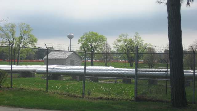
Photo: Nyttend, public domain · Wikimedia Commons
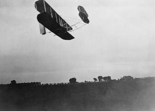
Photo: Photograph by Wilbur Wright, public domain · Wikimedia Commons
Local history sources: en.wikipedia.org · en.wikipedia.org · en.wikipedia.org · en.wikipedia.org · ohiogenealogyexpress.com · fairborndailyherald.com · commons.wikimedia.org · commons.wikimedia.org
Historic places
1 place in Bath Township, Greene County on the National Register of Historic Places. Press a pin or a name for its whole record.
-
Dayton Aviation Heritage National Historical ParkSite · Dayton
- Address
- P.O. Box 9280 Wright Brothers Station
- Where
- Dayton, Greene County · ZIP 45324
- What it is
- Site
- Latest NPS certification action
- 1988
- NRIS reference number
- 01000227
- Coordinates
- 39.79475, -84.08883
National Register file (NPS) ↗ Search Wikipedia ↗ Street map and directions ↗ On the Cracked Buckeye map
Source: National Park Service, National Register of Historic Places point file. The listing year is shown where NPS's certification date agrees with the listing's reference number. Listing recognizes significance; it does not restrict a private owner.
Water
Groundwater from the Area B well field: EPA SDWIS lists 9 wells for this system (B wells 0001, 002B, 0004-0010), 7 active and 2 inactive (0008, 0009). The base also reports an East Well Field, which SDWIS does not list as a source for this system. The water here
- Fairborn Public Water System58% of residentsMad River Buried Valley Aquifer (Mad River Well Field, wells)
- Wright-patterson Afb Area B13% of residentsGreat Miami/Mad River Buried Valley Aquifer (base wells, Area B)
- Huber Heights Public Water System9% of residentsGreat Miami Buried Valley Aquifer (wells)
- Wright-patterson Afb Area A6% of residentsGreat Miami/Mad River Buried Valley Aquifer (base wells, Area A)
- Yellow Springs Village5% of residentsGroundwater wells (4 wells)
- Greene County - Fairborn3% of residentsMad River Buried Valley Aquifer (Mad River Well Field, wells)
- Greene County - northwest Reg Water2% of residentsLittle Miami River Buried Valley Aquifer (2 wellfields, Beavercreek area)
- Dayton Public Water System2% of residentsGreat Miami Buried Valley Aquifer wells (recharged by Great Miami & Mad Rivers)
- Montgomery County Water Services 21% of residentsGreat Miami Buried Valley Aquifer wells (recharged by Great Miami & Mad Rivers)
- Montgomery County Water Services 10% of residentsGreat Miami Buried Valley Aquifer wells (recharged by Great Miami & Mad Rivers)
- Wright State University0% of residentsGreat Miami/Mad River Buried Valley Aquifer (campus wells, Greene Co.)
Hospitals, fire stations and more
Inside Bath Township, Greene County's boundary: 1 hospital, 1 fire or EMS station, 1 college, 1 high-hazard dam, 2 poor-rated bridges, 1 museum, 1 public charging site, 2 Superfund sites, 1 Toxics Release Inventory facility, 24 spill cases and 1 mound or earthwork. Press a pin or a name for its whole record and its source.
Hospitals (1)
-
88Th Medical Group - Wright - Patterson Air Force Base Medical CenterMilitary hospital · Wright-Patterson Afb
- What it is
- Military hospital
- Address
- 4881 Sugar Maple Drive, Wright-Patterson Afb, OH 45433
- County
- Greene County
- Beds
- 57
- Ownership
- Government - federal
- Medicare overall rating
- not rated
- Emergency department (Medicare)
- Yes
- Medicare reports it as
- 88Th Medical Group (Wright-Patterson Afb)
- Phone
- (937) 522-2778
- Medicare ID
- 36006F
Medicare Care Compare ↗ Hospital's website ↗ Where HIFLD got this record ↗ HIFLD hospitals (source) ↗ Street map and directions ↗
Source: HIFLD hospitals inventory via FEMA (closed hospitals it still lists left out, hospitals opened since added), with Medicare Care Compare ratings matched by name and address.
Fire and EMS stations (1)
-
Wright Patterson Air Force Base Fire Department and Emergency Medical Services DepartmentDayton
- Address
- 5160 Pearson Road, Dayton, OH 45433
- Coordinates
- 39.81814, -84.03678
USGS National Map structures (source) ↗ Street map and directions ↗
Source: USGS National Map structures (most Ohio records last updated 2019 to 2022), checked against the Columbus and Cleveland station lists. The department that answers a call is set by jurisdiction and mutual aid, not by distance.
Colleges (1)
-
Air Force Institute of Technology-Graduate School of Engineering & ManagementPublic university · Wright-Patterson AFB
- What it is
- Public university
- City
- Wright-Patterson AFB
- Students, 2023-24 (12-month count)
- 1,491
- IPEDS unit ID
- 200697
College Navigator (NCES) ↗ IPEDS data (source) ↗ Street map and directions ↗
Source: NCES IPEDS 2024 directory, 2023-24 enrollment and tuition, graduation rates for the 2017 (four-year) and 2020 (two-year) entering classes.
High-hazard dams (1)
-
Huffman DamMad River · condition: fair
- Hazard class
- High: a failure would probably cost a life
- Condition
- Fair (assessed 09/25/2019)
- River or stream
- Mad River
- Purpose
- Flood Risk Reduction
- Type
- Earth
- Height
- 73 ft
- Storage
- 297,000 acre-feet
- Completed
- 1922
- Owner type
- Local Government
- County
- Greene County
- Nearest town (NID)
- Dayton
- Last inspection
- 10/23/2024
- Emergency action plan
- Yes
- NID ID
- OH00426
National Inventory of Dams record ↗ National Inventory of Dams (source) ↗ Street map and directions ↗
Source: U.S. Army Corps of Engineers National Inventory of Dams, August 2026. "High hazard" rates what a failure would cost downstream, not how likely one is; the condition is the state's assessment.
Bridges rated poor (2)
-
Hebble Creek Road over Hebble CreekPoor · built 1976
- Condition
- Poor: a deck, superstructure, substructure or culvert rated 4 or below on the 0 to 9 scale
- What it is
- Culvert
- Built
- 1976
- Length
- 9 ft
- Owner
- Other
- Vehicles a day
- 1,000
- Coordinates
- 39.79975, -84.05933
National Bridge Inventory (source) ↗ Street map and directions ↗
-
Sb SR 4 over T168(union Road)Poor · built 1959
- Condition
- Poor: a deck, superstructure, substructure or culvert rated 4 or below on the 0 to 9 scale
- What it is
- Bridge
- Built
- 1959
- Length
- 38 ft
- Owner
- State
- Vehicles a day
- 10,605
- Coordinates
- 39.81350, -84.08497
National Bridge Inventory (source) ↗ Street map and directions ↗
Source: FHWA National Bridge Inventory 2025. "Poor" means one major part rated 4 or below on the 0 to 9 scale; it calls for repair, not closing, unless the state posts or closes the bridge.
Museums, historical societies, gardens and zoos (1)
-
Antique Studebaker Museum Of OhioMuseum · Fairborn
- What it is
- Museum
- City
- Fairborn
- Coordinates
- 39.82292, -83.95336
Search Wikipedia ↗ IMLS Museum Data Files (source) ↗ Street map and directions ↗
The museum list is IMLS's 2018 file; a museum may have closed or moved since.
Source: IMLS Museum Data Files, 2018.
Public EV charging (1)
-
Wagner Subaru2 Level 2 · Fairborn
- Address
- 5470 Intrastate Drive, Fairborn, OH 45324
- Ports
- 2 Level 2
- Plugs
- J1772
- Network
- Blink Network
- Hours
- 24 hours daily
- Phone
- 888-998-2546
Station Locator (NREL) ↗ Alternative Fuels Data Center (source) ↗ Street map and directions ↗
Source: NREL Alternative Fuels Data Center station list (May 2026), public and open stations, the posts at one address counted as one site.
Superfund sites (2)
-
Fairborn Mercury Spill ErSuperfund program · Fairborn
- Address
- 3881 Oh-235, Fairborn, OH 45324
- County
- -- Not Defined -- County
- Status
- Superfund program site, not on the National Priorities List
- EPA program ID
- OHN000522224
- EPA registry ID
- 110072166942
EPA facility record ↗ EPA Facility Registry Service (source) ↗ Street map and directions ↗
-
Wright-Patterson Air Force Base NPLSuperfund, NPL · Dayton
- Address
- St Rte 444, Dayton, OH 45324
- County
- -- Not Defined -- County
- Status
- On the National Priorities List
- Federal facility
- Yes
- EPA program ID
- OH7571724312
- EPA registry ID
- 110071102252
EPA facility record ↗ EPA Facility Registry Service (source) ↗ Street map and directions ↗
Source: EPA Facility Registry Service, Superfund (SEMS) and National Priorities List sites. Many program sites were assessed and needed no cleanup.
Facilities reporting toxic releases (1)
-
Wright-Patterson Air Force BaseToxics Release Inventory · Wright-Patterson Afb
- Address
- 5135 Pearson Rd, Wright-Patterson Afb, OH 45433
- County
- Greene County
- Status
- Reports to the Toxics Release Inventory (active)
- Federal facility
- Yes
- EPA program ID
- 45433SDDSFDEPAR
- EPA registry ID
- 110001987958
EPA facility record ↗ EPA Facility Registry Service (source) ↗ Street map and directions ↗
Source: EPA Facility Registry Service, Toxics Release Inventory reporters. Reporting a release is required of large users of listed chemicals; it is not by itself a violation.
Spills reported since 2021 (24)
-
Fuel Diesel / Diesel Fuel (Vehicle On Or Off Road)2025-11-21 · Bath Twp
- Reported
- 2025-11-21
- What spilled
- Fuel Diesel / Diesel Fuel (Vehicle On Or Off Road)
- Where
- Bath Twp, Greene County
- Ohio EPA district office
- SWDO
- Ohio EPA case number
- 2511EPA0001902
Ohio EPA spill reports (source) ↗ Street map and directions ↗
-
Mercury / Quicksilver (Hg)2025-09-07 · Bath Twp
- Reported
- 2025-09-07
- What spilled
- Mercury / Quicksilver (Hg)
- Where
- Bath Twp, Greene County
- Ohio EPA district office
- SWDO
- Ohio EPA case number
- 2509EPA0001515
Ohio EPA spill reports (source) ↗ Street map and directions ↗
-
Oil Hydraulic Fluid(S)2025-03-28 · Bath Twp
- Reported
- 2025-03-28
- What spilled
- Oil Hydraulic Fluid(S); Fuel Diesel / Diesel Fuel (Vehicle On Or Off Road)
- Largest amount reported
- 100 gallons
- Where
- Bath Twp, Greene County
- Ohio EPA district office
- SWDO
- Ohio EPA case number
- 2503EPA0000450
Ohio EPA spill reports (source) ↗ Street map and directions ↗
-
Fuel Diesel / Diesel Fuel (Vehicle On Or Off Road)2025-03-17 · Bath Twp
- Reported
- 2025-03-17
- What spilled
- Fuel Diesel / Diesel Fuel (Vehicle On Or Off Road)
- Where
- Bath Twp, Greene County
- Ohio EPA district office
- SWDO
- Ohio EPA case number
- 2503EPA0000384
Ohio EPA spill reports (source) ↗ Street map and directions ↗
-
Fuel Jet / Kerosene (All)2025-02-04 · Bath Twp
- Reported
- 2025-02-04
- What spilled
- Fuel Jet / Kerosene (All)
- Largest amount reported
- 90 gallons
- Where
- Bath Twp, Greene County
- Ohio EPA district office
- SWDO
- Ohio EPA case number
- 2502EPA0000151
Ohio EPA spill reports (source) ↗ Street map and directions ↗
-
Mercury / Quicksilver (Hg)2025-01-27 · Bath Twp
- Reported
- 2025-01-27
- What spilled
- Mercury / Quicksilver (Hg)
- Where
- Bath Twp, Greene County
- Ohio EPA district office
- SWDO
- Ohio EPA case number
- 2501EPA0000105
Ohio EPA spill reports (source) ↗ Street map and directions ↗
-
Propylene Glycol (C3H8O2) Reached water2025-01-22 · Bath Twp
- Reported
- 2025-01-22
- What spilled
- Propylene Glycol (C3H8O2)
- Largest amount reported
- 200 gallons
- Reached a waterway
- 29 - Hebble Creek
- Where
- Bath Twp, Greene County
- Ohio EPA district office
- SWDO
- Ohio EPA case number
- 2501EPA0000084
Ohio EPA spill reports (source) ↗ Street map and directions ↗
-
Oil Petroleum Not Otherwise Specified (Nos)2024-05-06 · Bath Twp
- Reported
- 2024-05-06
- What spilled
- Oil Petroleum Not Otherwise Specified (Nos)
- Largest amount reported
- 5 gallons
- Where
- Bath Twp, Greene County
- Ohio EPA district office
- SWDO
- Ohio EPA case number
- 2405EPA0000758
Ohio EPA spill reports (source) ↗ Street map and directions ↗
-
Material White Reached water2024-05-06 · Bath Twp
- Reported
- 2024-05-06
- What spilled
- Material White
- Reached a waterway
- 29 - Mad River
- Where
- Bath Twp, Greene County
- Ohio EPA district office
- SWDO
- Ohio EPA case number
- 2405EPA0000757
Ohio EPA spill reports (source) ↗ Street map and directions ↗
-
Foam Reached water2023-09-14 · Bath Twp
- Reported
- 2023-09-14
- What spilled
- Foam
- Largest amount reported
- 30 gallons
- Reached a waterway
- 99 - Unnamed
- Where
- Bath Twp, Greene County
- Ohio EPA district office
- SWDO
- Ohio EPA case number
- 2309EPA0001610
Ohio EPA spill reports (source) ↗ Street map and directions ↗
-
Fuel Diesel / Diesel Fuel (Vehicle On Or Off Road)2023-08-23 · Bath Twp
- Reported
- 2023-08-23
- What spilled
- Fuel Diesel / Diesel Fuel (Vehicle On Or Off Road)
- Largest amount reported
- 70 gallons
- Where
- Bath Twp, Greene County
- Ohio EPA district office
- SWDO
- Ohio EPA case number
- 2308EPA0001455
Ohio EPA spill reports (source) ↗ Street map and directions ↗
-
Fuel Jet / Kerosene (All)2023-07-19 · Bath Twp
- Reported
- 2023-07-19
- What spilled
- Fuel Jet / Kerosene (All)
- Largest amount reported
- 150 gallons
- Where
- Bath Twp, Greene County
- Ohio EPA district office
- SWDO
- Ohio EPA case number
- 2307EPA0001213
Ohio EPA spill reports (source) ↗ Street map and directions ↗
-
Fuel Diesel / Diesel Fuel (Vehicle On Or Off Road)2023-03-20 · Bath Twp
- Reported
- 2023-03-20
- What spilled
- Fuel Diesel / Diesel Fuel (Vehicle On Or Off Road)
- Where
- Bath Twp, Greene County
- Ohio EPA district office
- SWDO
- Ohio EPA case number
- 2303EPA0000407
Ohio EPA spill reports (source) ↗ Street map and directions ↗
-
Oil Hydraulic Fluid(S)2023-02-27 · Bath Twp
- Reported
- 2023-02-27
- What spilled
- Oil Hydraulic Fluid(S)
- Largest amount reported
- 5 gallons
- Where
- Bath Twp, Greene County
- Ohio EPA district office
- SWDO
- Ohio EPA case number
- 2302EPA0000297
Ohio EPA spill reports (source) ↗ Street map and directions ↗
-
Oil Petroleum Not Otherwise Specified (Nos)2022-10-20 · Null
- Reported
- 2022-10-20
- What spilled
- Oil Petroleum Not Otherwise Specified (Nos)
- Where
- Null, Greene County
- Ohio EPA district office
- SWDO
- Ohio EPA case number
- 2210EPA0001581
Ohio EPA spill reports (source) ↗ Street map and directions ↗
-
Foam2022-09-10 · Bath Twp
- Reported
- 2022-09-10
- What spilled
- Foam
- Largest amount reported
- 50 gallons
- Where
- Bath Twp, Greene County
- Ohio EPA district office
- SWDO
- Ohio EPA case number
- 2209EPA0001382
Ohio EPA spill reports (source) ↗ Street map and directions ↗
-
Other / All Other / Trade Name / Mixture / Solution Etc2022-08-09 · Bath Twp
- Reported
- 2022-08-09
- What spilled
- Other / All Other / Trade Name / Mixture / Solution Etc; Sewage Human
- Largest amount reported
- 4 gallons
- Where
- Bath Twp, Greene County
- Ohio EPA district office
- SWDO
- Ohio EPA case number
- 2208EPA0001208
Ohio EPA spill reports (source) ↗ Street map and directions ↗
-
Oil Hydraulic Fluid(S) Reached water2022-06-09 · Bath Twp
- Reported
- 2022-06-09
- What spilled
- Oil Hydraulic Fluid(S)
- Largest amount reported
- 1 gallons
- Reached a waterway
- 29 - Hebble Creek
- Where
- Bath Twp, Greene County
- Ohio EPA district office
- SWDO
- Ohio EPA case number
- 2206EPA0000861
Ohio EPA spill reports (source) ↗ Street map and directions ↗
-
Oil Hydraulic Fluid(S)2022-06-07 · Bath Twp
- Reported
- 2022-06-07
- What spilled
- Oil Hydraulic Fluid(S)
- Largest amount reported
- 35 gallons
- Where
- Bath Twp, Greene County
- Ohio EPA district office
- SWDO
- Ohio EPA case number
- 2206EPA0000846
Ohio EPA spill reports (source) ↗ Street map and directions ↗
-
Oil Motor / Lube Oil / Vehicle Reached water2022-02-05 · Bath Twp
- Reported
- 2022-02-05
- What spilled
- Oil Motor / Lube Oil / Vehicle
- Reached a waterway
- 99 - Unnamed
- Where
- Bath Twp, Greene County
- Ohio EPA district office
- SWDO
- Ohio EPA case number
- 2202EPA0000136
Ohio EPA spill reports (source) ↗ Street map and directions ↗
-
Fuel Diesel / Diesel Fuel (Vehicle On Or Off Road)2021-08-26 · Bath Twp
- Reported
- 2021-08-26
- What spilled
- Fuel Diesel / Diesel Fuel (Vehicle On Or Off Road)
- Largest amount reported
- 34 gallons
- Where
- Bath Twp, Greene County
- Ohio EPA district office
- SWDO
- Ohio EPA case number
- 2108EPA0001342
Ohio EPA spill reports (source) ↗ Street map and directions ↗
-
Oil Hydraulic Fluid(S)2021-07-20 · Bath Twp
- Reported
- 2021-07-20
- What spilled
- Oil Hydraulic Fluid(S)
- Largest amount reported
- 100 gallons
- Where
- Bath Twp, Montgomery County
- Ohio EPA district office
- SWDO
- Ohio EPA case number
- 2107EPA0001096
Ohio EPA spill reports (source) ↗ Street map and directions ↗
-
Antifreeze Vehicle Cooling2021-06-20 · Bath Twp
- Reported
- 2021-06-20
- What spilled
- Antifreeze Vehicle Cooling
- Where
- Bath Twp, Greene County
- Ohio EPA district office
- SWDO
- Ohio EPA case number
- 2106EPA0000901
Ohio EPA spill reports (source) ↗ Street map and directions ↗
-
Oil Motor / Lube Oil / Vehicle2021-06-07 · Bath Twp
- Reported
- 2021-06-07
- What spilled
- Oil Motor / Lube Oil / Vehicle
- Largest amount reported
- 1 gallons
- Where
- Bath Twp, Greene County
- Ohio EPA district office
- SWDO
- Ohio EPA case number
- 2106EPA0000805
Ohio EPA spill reports (source) ↗ Street map and directions ↗
Source: Ohio EPA emergency response spill reports, 2021 to September 2026, one point per case where Ohio EPA placed it. A report is what the caller or responder recorded; amounts are often blank or estimated.
Mounds and earthworks (1)
-
Wright-Patterson Air Force Base MoundMound · Adena culture
- What it is
- Mound
- Age
- Adena culture, c. 500 BC - AD 400
- Where
- Wright-Patterson AFB, about 0.62 miles south of the Wright Brothers Memorial on Huffman Prairie, Bath Township
- County
- Greene County
- Named in the history of
- Bath Township, Greene County, Greene County
- Map point
- from the site's Wikipedia article
Wikipedia article (point and source) ↗ Street map and directions ↗
Many mounds stand on private land; visit only those open to the public.
Source: the History records' native sites, each placed by its own Wikipedia article; sites no article places are named on the History card but not pinned.
Its ZIP codes
Each ZIP code that touches Bath Township, Greene County, with the share of its residents who live here and the same headline figures as the ZIP page.
Local government
Who holds office in Bath Township, Greene County, how its elections and ballot issues came out, and the state auditor's record.
Money issues on the ballot since 2019: 1 of 1 passed.
Ballot issues
| Date | Issue | For | Against | Result |
|---|---|---|---|---|
| 2020-11-03 | Issue: Bath TWP – Renewal - Streets #6 | 1,119 | 666 | Passed (62.69% for) |
| 2019-11-05 | Issue: Bath Township Fire Tax Levy #1 | 411 | 119 | Passed (77.55% for) |
Elections for office
| Date | Office | Candidates and votes |
|---|---|---|
| 2021-11-02 | Township Trustee | Michelle Clements 2,558, 35.37%; Rob Hoffman 2,573, 35.58%; Tom Pitstick 938, 12.97%; Steve Ross 1,163, 16.08% |
| 2019-11-05 | Township Trustee | Jeffrey G. Flora 781, 25.92%; Kassie Lester 1,381, 45.83%; Tim Steininger 851, 28.24% |
| 2019-11-05 | Township Fiscal Officer | Elaine M. Brown 2,704, 100.0% |
| 2017-11-07 | Township Trustee | Michelle Clements-Pi 1,715, 25.72%; John O. Martin 2,462, 36.92%; Tom Pitstick 2,492, 37.37% |
Winners in bold. Results from the county board of elections' official canvass unless marked.
Auditor of State record
- No fiscal caution, watch or emergency on the Auditor of State's lists.
- Financial Audit, 2023 to 2024, released 2026-05-12
The county
Greene County: 17 ZIP codes, 23 cities, villages and townships, 178,891 people.
Nearby places
Quick answers
What county is Bath Township, Ohio in?
Bath Township, Greene County is a township in Greene County, Ohio, with 6,022 residents.
When was Bath Township, Ohio founded?
Bath Township, Greene County was settled before 1799 (Mercer family, from Virginia); incorporated 1807 (township organized). Founders on record: Greene County's early township organization; first settled by the Mercer family. Source
How did Bath Township, Ohio get its name?
Bath Township was named for Bath, Maine, because one of its early settlers had come from that city; Bath, Maine was in turn named for Bath, England. Source
What ZIP code is Bath Township, Ohio?
Bath Township, Greene County is served by ZIP codes 45433, 45324 and 45387; 45433 holds the largest share of its residents.
Where does Bath Township, Ohio get its water?
The main water source for Bath Township, Greene County (Fairborn Public Water System): Groundwater from the Area B well field: EPA SDWIS lists 9 wells for this system (B wells 0001, 002B, 0004-0010), 7 active and 2 inactive (0008, 0009). The base also reports an East Well Field, which SDWIS does not list as a source for this system.
Cite this page
Cite this page as:
Cracked Buckeye, "Bath Township, Greene County", https://crackedbuckeye.com/place/bath-township-greene-county/, built 2026-10-31, accessed [date].
How to cite · Report a correction · Built 2026-10-31
