Local events in Reading
6 events in the next 90 days from 2 public calendars. All local events in Reading
Checked October 20; the events page is refreshed daily.
How Reading began
Abraham Voorhees moved his family from New Jersey in 1794 and built a double log cabin on the west bank of Mill Creek, then platted a town around 1798 originally called Voorhees-Town, though the plat was not officially recorded until 1804. A Pennsylvania Dutch visitor, Harvey Redinbo, persuaded Voorhees to rename the settlement for Redinbo's own hometown of Reading, Pennsylvania. Reading grew fast on clothing manufacturing between 1830 and 1880, becoming the largest village in Hamilton County, and incorporated as a village in 1851 and a city in 1932. Census records document Reading as a sundown town: a 1912 Cincinnati Post article reported that African Americans were not allowed to live there or remain after dark, and the city's census counted essentially no Black residents from 1860 through 1960. Population peaked around 12,832 in 1960; the 2020 census recorded 10,600.
Settled 1794 (Abraham Voorhees), platted c. 1798, recorded 1804 (as Voorhees-Town), incorporated village, March 24, 1851; city, January 1, 1932, by Abraham Voorhees; renamed at the urging of Harvey Redinbo.
Where the name comes from
The town was first known as Voorhees-Town, for founder Abraham Voorhees. A Pennsylvania Dutch visitor named Harvey Redinbo convinced Voorhees to rename it Reading, after Redinbo's hometown of Reading, Pennsylvania.
Before the town
No Native village, mound, or documented encounter specific to Reading itself was found in the sources consulted.
Timeline
- — Abraham Voorhees moves his family from New Jersey and builds a double log cabin on the west bank of Mill Creek.
- — Voorhees plats a town, initially called Voorhees-Town; the plat is not officially recorded until 1804.
- — Reading grows rapidly on clothing manufacturing, becoming the largest village in Hamilton County.
- — Reading incorporates as a village on March 24.
- — Population is 1,230; census records from this year through 1960 show essentially no Black residents.
- — The Benson Street Bridge is built over Mill Creek on the Reading-Lockland line, the second concrete rainbow-arch bridge built and the first in Ohio.
- — The city institutes a youth curfew, signaled by a bell tower.
- — A Cincinnati Post article documents Reading as a sundown town after a racially motivated attack, quoting that "Negroes are not allowed to live in Reading or stay there after dark."
- — Reading becomes a city on January 1.
- — The city publishes a centennial souvenir booklet marking its history, including its World War I monument at Vine and Jefferson streets honoring Clarence Halker, the first Reading resident killed in that war.
- — Population peaks around 12,832.
- — Census population is 10,600.
Stories
A name changed by a visitor
Abraham Voorhees had already built his log cabin on Mill Creek and platted his own town, naming it Voorhees-Town after himself, when a Pennsylvania Dutch traveler named Harvey Redinbo came through and talked him into giving it up. Redinbo wanted the place named for his own hometown, Reading, Pennsylvania, and Voorhees agreed -- an unusual concession for a man who had put his own name on a map only to erase it at a stranger's suggestion. The renamed town went on to outgrow the man who founded it many times over: by the mid-1800s Reading's clothing factories had made it the largest village in Hamilton County, propelled by decades of population growth Voorhees-Town, a name that survives now only in old plat records, never saw.
A documented sundown town
In 1912, after a racially motivated attack in the area stirred what a Cincinnati Post reporter called greater indignation than similar attacks nearby, the paper reported plainly that "Negroes are not allowed to live in Reading or stay there after dark." It was not an isolated claim: Reading's own census returns from 1860 through 1960, a full century, recorded essentially no Black residents at all, the kind of pattern historians use to identify a sundown town -- a community that enforced racial exclusion by custom, intimidation, or open threat rather than by any law on the books. Reading was hardly unique in this among Cincinnati's ring of white-flight suburbs and mill towns, but it is one of the few in Hamilton County where a contemporary newspaper documented the practice explicitly, in the town's own words, rather than leaving it to be inferred from a century of one-sided census numbers alone.
Photographs
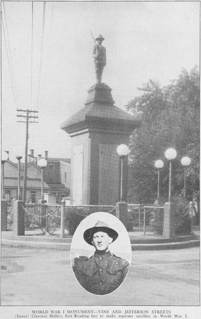
Photo: City of Reading, Ohio, published by Schulte & Cappel, public domain · Wikimedia Commons
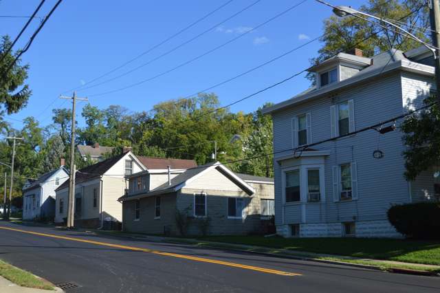
Photo: Nyttend, public domain · Wikimedia Commons
Local history sources: en.wikipedia.org · commons.wikimedia.org · commons.wikimedia.org
Water
13 wells in the Great Miami Buried Valley Aquifer along the Great Miami River near Fairfield, Butler Co. The water here
- Cincinnati Public Water System48% of residentsOhio River (Miller Plant, ~88%) plus Great Miami Buried Valley Aquifer wells (~12%)
- Reading City27% of residentsOhio River (Miller Plant, ~88%) plus Great Miami Buried Valley Aquifer wells (~12%)
- Wyoming City25% of residentsMill Creek valley aquifer (6 city wells)
Hospitals, fire stations and more
Inside Reading's boundary: 1 nursing home, 2 fire and EMS stations, 3 public schools, 2 private schools, 1 library, 1 museum, 1 police station, 1 Superfund site, 5 Toxics Release Inventory facilities and 8 spill cases. Press a pin or a name for its whole record and its source.
Nursing homes (1)
-
Mount Notre Dame Health Center5 of 5 stars · Cincinnati
- Address
- 699 East Columbia Avenue, Cincinnati, OH 45215
- Certified beds
- 40
- Residents on an average day
- 36
- Medicare overall rating
- 5 of 5 stars
- Health inspections
- 5 of 5 stars
- Staffing
- 4 of 5 stars
- Quality measures
- 4 of 5 stars
- Penalties since 2023
- none
- Ownership
- Non profit - Church related
- Takes
- Medicare and Medicaid
- Phone
- (513) 821-7448
- Medicare ID
- 366223
Medicare Care Compare ↗ CMS nursing home data (source) ↗ Street map and directions ↗
Source: CMS Care Compare nursing home provider and penalties files; Medicare star ratings run 1 to 5.
Fire and EMS stations (2)
-
Reading Fire DepartmentReading
- Address
- 1000 Market Street, Reading, OH 45215
- Coordinates
- 39.22395, -84.44164
USGS National Map structures (source) ↗ Street map and directions ↗
-
Reading Fire Department Hilltop StationReading
- Address
- 601 East Columbia Avenue, Reading, OH 45215
- Coordinates
- 39.22329, -84.43210
USGS National Map structures (source) ↗ Street map and directions ↗
Source: USGS National Map structures (most Ohio records last updated 2019 to 2022), checked against the Columbus and Cleveland station lists. The department that answers a call is set by jurisdiction and mutual aid, not by distance.
Public schools (3)
-
Cincinnati Classical AcademyCincinnati
- Address
- 175 Siebenthaler Ave, Cincinnati, OH 45215
- Kind (NCES)
- Regular School
- Students, 2023-24
- 602
- Teachers (full-time equivalent)
- 33.1
- NCES school ID
- 391003410838
-
Reading Elementary School3 of 5 stars · Reading
- Address
- 810 E Columbia Ave, Reading, OH 45215
- School district
- Reading Community City School District
- Kind (NCES)
- Regular School
- Students, 2023-24
- 776
- Teachers (full-time equivalent)
- 48.11
- Report card, 2025-26
- 3 of 5 stars
- Performance index
- 68.8%
- Ohio building IRN
- 005728
- NCES school ID
- 390446901568
NCES school record ↗ Ohio School Report Card ↗ Street map and directions ↗
-
Reading Junior Senior High School4 of 5 stars · Reading
- Address
- 810 E Columbia Ave, Reading, OH 45215
- School district
- Reading Community City School District
- Kind (NCES)
- Regular School
- Students, 2023-24
- 666
- Teachers (full-time equivalent)
- 42.66
- Report card, 2025-26
- 4 of 5 stars
- Performance index
- 71.1%
- Four-year graduation rate
- 97.1%
- Ohio building IRN
- 031187
- NCES school ID
- 390446901571
NCES school record ↗ Ohio School Report Card ↗ Street map and directions ↗
Source: NCES EDGE public school locations 2024-25 and Common Core of Data 2023-24 (type, students, teachers); Ohio School Report Cards 2025-26 (Department of Education and Workforce), matched by name within the district.
Private schools (2)
-
Mount Notre Dame High SchoolPrivate, Catholic · Cincinnati
- Address
- 711 E Columbia Ave, Cincinnati, OH 45215
- Kind
- Catholic
- Students, 2023-24
- 664
- Teachers (full-time equivalent)
- 32.6
- Students per teacher
- 20.3681
- Phone
- (513) 821-3044
- NCES private school ID
- 01056631
-
Sts Peter & Paul AcademyPrivate, Catholic · Reading
- Address
- 231 Clark Rd, Reading, OH 45215
- Kind
- Catholic
- Students, 2023-24
- 131
- Teachers (full-time equivalent)
- 13.9
- Students per teacher
- 9.42446
- Phone
- (513) 761-7772
- NCES private school ID
- A0902602
Source: NCES Private School Survey 2023-24.
Public libraries (1)
-
ReadingBranch · Reading
- Address
- 8740 Reading Rd., Reading, OH 45215
- What it is
- Branch
- Library system
- Cincinnati and Hamilton County Public Library
- Open
- 3,016 hours a year, 52 weeks
- Building
- 12,000 sq ft
- System's visits, FY2024
- 4,091,256
- System's loans, FY2024
- 20,126,186
- People the system serves
- 830,639
- Phone
- (513) 369-4465
IMLS Public Libraries Survey (source) ↗ Street map and directions ↗
Source: IMLS Public Libraries Survey FY2024 (outlets and their systems). Any Ohio resident can get a free card at any Ohio public library.
Museums, historical societies, gardens and zoos (1)
-
Reading Historical SocietyHistorical society · Reading
- What it is
- Historical society
- City
- Reading
- Coordinates
- 39.22293, -84.44223
Search Wikipedia ↗ IMLS Museum Data Files (source) ↗ Street map and directions ↗
The museum list is IMLS's 2018 file; a museum may have closed or moved since.
Source: IMLS Museum Data Files, 2018.
Police stations (1)
-
Reading Police DepartmentReading
- Address
- 1000 Market Street, Reading, OH 45215
- Coordinates
- 39.22396, -84.44141
USGS National Map structures (source) ↗ Street map and directions ↗
Source: USGS National Map structures, police stations, corrected and completed by hand (September 2026). The department that answers a call is set by jurisdiction, not by distance.
Superfund sites (1)
-
Pristine, Inc. NPLSuperfund, NPL · Reading
- Address
- 410 Cavett Ave, Reading, OH 45215
- County
- Hamilton County
- Status
- On the National Priorities List
- EPA program ID
- OHD076773712
- EPA registry ID
- 110042019197
EPA facility record ↗ EPA Facility Registry Service (source) ↗ Street map and directions ↗
Source: EPA Facility Registry Service, Superfund (SEMS) and National Priorities List sites. Many program sites were assessed and needed no cleanup.
Facilities reporting toxic releases (5)
-
Aluchem IncToxics Release Inventory · Cincinnati
- Address
- 1 Landy Lane, Cincinnati, OH 45215
- County
- Hamilton County
- Status
- Reports to the Toxics Release Inventory (active)
- EPA program ID
- 45215LCHMN1LAND
- EPA registry ID
- 110001629480
EPA facility record ↗ EPA Facility Registry Service (source) ↗ Street map and directions ↗
-
Liebel-Flarsheim CompanyToxics Release Inventory · Cincinnati
- Address
- 2111 East Galbraith Road, Cincinnati, OH 45237
- County
- Hamilton County
- Status
- Reports to the Toxics Release Inventory (active)
- EPA program ID
- 45215LBLFL2111E
- EPA registry ID
- 110001627311
EPA facility record ↗ EPA Facility Registry Service (source) ↗ Street map and directions ↗
-
Nitto Denko Avecia - Internal Tank FarmToxics Release Inventory · Cincinnati
- Address
- 8560 Reading Road, Cincinnati, OH 45215
- County
- Hamilton County County
- Status
- Reports to the Toxics Release Inventory
- EPA program ID
- 45215GRNDS856RE
- EPA registry ID
- 110004738990
EPA facility record ↗ EPA Facility Registry Service (source) ↗ Street map and directions ↗
-
Patheon Pharmaceuticals Inc. (1431380503)Toxics Release Inventory · Cincinnati
- Address
- 2110 East Galbraith Road, Cincinnati, OH 45237
- County
- Hamilton County
- Status
- Reports to the Toxics Release Inventory (active)
- EPA program ID
- 45215MRRLL2110E
- EPA registry ID
- 110001625279
EPA facility record ↗ EPA Facility Registry Service (source) ↗ Street map and directions ↗
-
Rohm and Haas Chemicals Llc- Cincinnati PlantToxics Release Inventory · Cincinnati
- Address
- 2000 West Street, Cincinnati, OH 45215
- County
- Hamilton County
- Status
- Reports to the Toxics Release Inventory (active)
- EPA program ID
- 45215MRTNT2000W
- EPA registry ID
- 110035829547
EPA facility record ↗ EPA Facility Registry Service (source) ↗ Street map and directions ↗
Source: EPA Facility Registry Service, Toxics Release Inventory reporters. Reporting a release is required of large users of listed chemicals; it is not by itself a violation.
Spills reported since 2021 (8)
-
Fuel Diesel / Diesel Fuel (Vehicle On Or Off Road)2025-05-20 · Reading
- Reported
- 2025-05-20
- What spilled
- Fuel Diesel / Diesel Fuel (Vehicle On Or Off Road)
- Where
- Reading, Hamilton County
- Ohio EPA district office
- SWDO
- Ohio EPA case number
- 2505EPA0000800
Ohio EPA spill reports (source) ↗ Street map and directions ↗
-
Concrete Reached water2024-09-13 · Reading
- Reported
- 2024-09-13
- What spilled
- Concrete
- Largest amount reported
- 100 gallons
- Reached a waterway
- 31 - Mill Creek
- Where
- Reading, Hamilton County
- Ohio EPA district office
- SWDO
- Ohio EPA case number
- 2409EPA0001576
Ohio EPA spill reports (source) ↗ Street map and directions ↗
-
Oil Transformer Non Pcb2024-08-11 · Reading
- Reported
- 2024-08-11
- What spilled
- Oil Transformer Non Pcb
- Largest amount reported
- 38 gallons
- Where
- Reading, Hamilton County
- Ohio EPA district office
- SWDO
- Ohio EPA case number
- 2408EPA0001389
Ohio EPA spill reports (source) ↗ Street map and directions ↗
-
Oil Motor / Lube Oil / Vehicle2023-11-09 · Reading
- Reported
- 2023-11-09
- What spilled
- Oil Motor / Lube Oil / Vehicle
- Largest amount reported
- 40 gallons
- Where
- Reading, Hamilton County
- Ohio EPA district office
- SWDO
- Ohio EPA case number
- 2311EPA0001906
Ohio EPA spill reports (source) ↗ Street map and directions ↗
-
Oil Hydraulic Fluid(S)2023-09-09 · Reading
- Reported
- 2023-09-09
- What spilled
- Oil Hydraulic Fluid(S); Fuel Diesel / Diesel Fuel (Vehicle On Or Off Road)
- Where
- Reading, Hamilton County
- Ohio EPA district office
- SWDO
- Ohio EPA case number
- 2309EPA0001576
Ohio EPA spill reports (source) ↗ Street map and directions ↗
-
Sewage Sludge / Biosolids Reached water2022-06-16 · Reading
- Reported
- 2022-06-16
- What spilled
- Sewage Sludge / Biosolids
- Reached a waterway
- 31 - Mill Creek
- Where
- Reading, Hamilton County
- Ohio EPA district office
- SWDO
- Ohio EPA case number
- 2206EPA0000903
Ohio EPA spill reports (source) ↗ Street map and directions ↗
-
Oil Hydraulic Fluid(S)2022-04-26 · Reading
- Reported
- 2022-04-26
- What spilled
- Oil Hydraulic Fluid(S)
- Largest amount reported
- 10 gallons
- Where
- Reading, Hamilton County
- Ohio EPA district office
- SWDO
- Ohio EPA case number
- 2204EPA0000582
Ohio EPA spill reports (source) ↗ Street map and directions ↗
-
Sheen Rainbow / Hydrocarbon Reached water2021-02-12 · Reading
- Reported
- 2021-02-12
- What spilled
- Sheen Rainbow / Hydrocarbon
- Reached a waterway
- 31 - Mill Creek
- Where
- Reading, Hamilton County
- Ohio EPA district office
- SWDO
- Ohio EPA case number
- 2102EPA0000198
Ohio EPA spill reports (source) ↗ Street map and directions ↗
Source: Ohio EPA emergency response spill reports, 2021 to September 2026, one point per case where Ohio EPA placed it. A report is what the caller or responder recorded; amounts are often blank or estimated.
Its ZIP codes
Each ZIP code that touches Reading, with the share of its residents who live here and the same headline figures as the ZIP page.
Local government
Who holds office in Reading, how its elections and ballot issues came out, and the state auditor's record.
Ballot issues
| Date | Issue | For | Against | Result |
|---|---|---|---|---|
| 2021-11-02 | Issue 9: SPECIAL ELECTION BY PETITION LOCAL OPTION ELECTION ON SUNDAY SALE OF LIQUOR (READING 1-A) | 204 | 81 | Passed (71.58% for) |
Elections for office
| Date | Office | Candidates and votes |
|---|---|---|
| 2025-11-04 | Treasurer (REP primary) | Brenda A. Owens (REP) 1,137, 100.0% |
| 2025-11-04 | President of Council (REP primary) | Kevin M. Mattscheck (REP) 1,152, 100.0% |
| 2025-11-04 | Member of Council at Large (REP primary) | Katie Eadicicco (NON) 1,121, 28.74%; Shelly Kroeger 1,084, 27.79%; Scott V. Thamann (NON) 1,059, 27.15%; Robert J. Ashbrock (REP) 637, 16.33% |
| 2025-11-04 | Member of Council (4th Ward) (REP primary) | Robert P. Boehner (REP) 354, 100.0% |
| 2025-11-04 | Member of Council (3rd Ward) (REP primary) | Mark A. Bishop (REP) 266, 100.0% |
| 2025-11-04 | Member of Council (2nd Ward) (REP primary) | Andrew J. Bronner (REP) 220, 100.0% |
| 2025-11-04 | Member of Council (1st Ward) (REP primary) | David A. Powell (REP) 227, 100.0% |
| 2023-11-07 | President of Council | Kevin M. Mattscheck 2,025, 67.98%; Dwight Daum 954, 32.02% |
| 2023-11-07 | Member of Council at Large (REP primary) | Katie Eadicicco (NON) 2,082, 28.87%; Scott V. Thamann (NON) 1,820, 25.24%; Shelly Kroeger 1,752, 24.3%; Ken Wietmarschen (REP) 1,557, 21.59% |
| 2023-11-07 | Member of Council (4th Ward) (DEM primary) | Robert P. Boehner (REP) 714, 67.55%; James A. Shelton (DEM) 343, 32.45% |
| 2023-11-07 | Member of Council (3rd Ward) (REP primary) | Mark A. Bishop (REP) 648, 100.0% |
| 2023-11-07 | Member of Council (2nd Ward) | Andrew J. Bronner (REP) 377, 61.8%; Anthony J. Gertz 233, 38.2% |
| 2023-11-07 | Member of Council (1st Ward) (REP primary) | David A. Powell (REP) 512, 100.0% |
| 2023-11-07 | Mayor | Robert P. Bemmes (REP) 2,032, 59.45%; Robert J. Ashbrock 1,386, 40.55% |
| 2023-11-07 | Director of Law (REP primary) | David T. Stevenson (REP) 2,442, 100.0% |
| 2023-11-07 | Auditor (REP primary) | Sabrina A. Smith (REP) 2,510, 100.0% |
| 2021-11-02 | Treasurer (REP primary) | Brenda A. Owens (REP) 1,382, 100.0% |
| 2021-11-02 | President of Council | Dwight Daum (REP) 972, 55.16%; Christopher Nesbitt 790, 44.84% |
| 2021-11-02 | Member of Council at Large (REP primary) | Katie Eadicicco (NON) 1,224, 27.04%; Shelly Kroeger 936, 20.68%; Scott V. Thamann 837, 18.49%; Scott Bothe 800, 17.67%; Robert J. Ashbrock (REP) 730, 16.13% |
| 2021-11-02 | Member of Council (4th Ward) | Robert P. Boehner 427, 66.72%; James A. Shelton 213, 33.28% |
| 2021-11-02 | Member of Council (3rd Ward) | Mark A. Bishop (REP) 242, 54.88%; Kenneth C. Wietmarschen (Write In) 199, 45.12% |
| 2021-11-02 | Member of Council (2nd Ward) (REP primary) | Andrew J. Bronner (NON) 262, 68.41%; Anthony J. Gertz (REP) 121, 31.59% |
| 2021-11-02 | Member of Council (1st Ward) (REP primary) | David A. Powell (REP) 203, 100.0% |
Winners in bold. Results from the county board of elections' official canvass unless marked.
Auditor of State record
- No fiscal caution, watch or emergency on the Auditor of State's lists.
- Financial Health Indicators (the Auditor of State's 17 measures; critical / cautionary / positive): 2020 0 / 1 / 16; 2021 0 / 0 / 17; 2022 0 / 0 / 17; 2023 0 / 1 / 16; 2024 0 / 0 / 16; 2025 0 / 1 / 15.
- Financial Audit, 2022 to 2023, released 2024-08-15
The county
Hamilton County: 54 ZIP codes, 47 cities, villages and townships, 843,791 people.
Nearby places
Rain and snow
How much has actually fallen on Reading, day by day, from 1893 to now. Daily totals, not averages.
- rain, last 30 days
- 1.06 in
- 2026-09-29 to 2026-10-28
- rain so far in 2026
- 44.3 in
- 4.2 in above normal for the date
- snow so far in 2026
- 11.0 in
- a normal year brings 15.0 in
- a normal year
- 47.3 in
- average of 30 years, 1991-2020
| Month | Rain (in) | Snow (in) | Days counted |
|---|---|---|---|
| October 2026 | 1.05 | — | 28 |
| September 2026 | 6.11 | — | 30 |
| August 2026 | 5.40 | — | 31 |
| July 2026 | 5.13 | — | 31 |
| June 2026 | 6.32 | — | 30 |
| May 2026 | 6.88 | — | 31 |
| April 2026 | 3.78 | — | 30 |
| March 2026 | 6.64 | 0.1 | 31 |
| February 2026 | 1.24 | 3.6 | 28 |
| January 2026 | 1.74 | 7.3 | 31 |
| December 2025 | 2.58 | 10.7 | 31 |
| November 2025 | 3.90 | 1.8 | 30 |
| Wettest year | 2011 — 77.3 in |
|---|---|
| Driest year | 1901 — 22.4 in |
| Snowiest year | 2010 — 50.7 in |
| Wettest day on record | 5 March 1897 — 5.10 in |
| Heaviest snowfall in a day | 8 December 1917 — 11.39 in |
| Deepest snow on the ground | 6 February 1998 — 15.98 in |
Estimated, not measured. No rain gauge has ever stood inside Reading, so every figure here is worked out from the gauges around it - the nearest ones weighted most. Treat them as close estimates rather than readings.
47,956 days of records, 1893-01-01 to 2026-10-28. Source: NOAA NCEI GHCN-Daily, 3,240 gauges in and around Ohio. A day is "gauged" when a gauge standing inside the boundary reported it, and the value is the mean of those gauges. Otherwise it is interpolated by inverse distance from every gauge reporting within 50 miles. Nothing is carried forward, back-filled or smoothed. Against NOAA nClimDiv county monthly precipitation over 136,848 complete county-months (checked 2026-10-31): correlation 0.9515, median absolute difference 0.217 in a month. Built 2026-10-31 from the Cracked Buckeye precipitation archive. Snow is the softer number — snowfall is measured by hand with a ruler, no agency publishes a gridded county snowfall series, and blowing snow defeats every observer.
Environmental permits and filings
What Ohio EPA has on file for Reading: permits, inspections, violations, cleanups and the state loans behind sewer and water work. Every line links to the agency's own document.
- facilities and sites on file
- 46
- those placed on the map inside Reading
| Program | Facilities and sites |
|---|---|
| Hazardous waste | 13 |
| Air pollution | 10 |
| Contaminated-site cleanup | 7 |
| Site assessment | 4 |
| Wastewater and stormwater discharge | 4 |
| Voluntary cleanup | 3 |
| Landfills | 2 |
| Composting | 1 |
| Public drinking water | 1 |
| Wetland and stream fill | 1 |
| Date | Facility or site | What |
|---|---|---|
| PRISTINE INC, READING | Contaminated-site cleanup cleanup response | |
| READING CITY PWS | Public drinking water notice of violation | |
| READING CITY PWS | Public drinking water notice of violation | |
| PRISTINE INC, READING | Contaminated-site cleanup cleanup response | |
| READING CITY PWS | Public drinking water plan | |
| READING CITY PWS | Public drinking water warning letter | |
| PRISTINE INC, READING | Contaminated-site cleanup cleanup response | |
| PRISTINE INC, READING | Contaminated-site cleanup cleanup response | |
| PRISTINE INC, READING | Contaminated-site cleanup cleanup response | |
| READING CITY PWS | Public drinking water inspection | |
| READING CITY PWS | Public drinking water notice of violation | |
| PRISTINE INC, READING | Contaminated-site cleanup cleanup response | |
| BARRETT PAVING FACILITY ON MILL CREEK | Wetland and stream fill violation resolved | |
| GENERAL TOOL CO | Air pollution report | |
| NITTO DENKO AVECIA INC | Air pollution report | |
| DEAN'S BODY SHOP | Air pollution report | |
| PMC CINCINNATI INC | Hazardous waste inspection | |
| READING MUNICIPAL GARAGE | Composting report | |
| PMC CINCINNATI INC | Hazardous waste report | |
| PRISTINE INC, READING | Contaminated-site cleanup cleanup response | |
| READING CITY PWS | Public drinking water notice of violation | |
| BARRETT PAVING FACILITY ON MILL CREEK | Wetland and stream fill notice of violation | |
| PRISTINE INC, READING | Contaminated-site cleanup cleanup response | |
| NIVISON PROPERTY, READING | Voluntary cleanup inspection | |
| PRISTINE INC, READING | Contaminated-site cleanup cleanup response |
Source: Ohio EPA eDocument portal (edocpub.epa.ohio.gov), indexed 2026-10-14. Facilities are placed on the map from Ohio EPA's own map layers, EPA's Facility Registry, coordinates written in the filings, or a geocoded street address. A permit filed under a private person's name (most are household septic systems) is counted but never named, placed or linked; licenses for individual workers and open-burning notices are left out entirely.
Quick answers
What county is Reading, Ohio in?
Reading is a city in Hamilton County, Ohio, with 10,600 residents.
When was Reading, Ohio founded?
Reading was settled 1794 (Abraham Voorhees); laid out c. 1798, recorded 1804 (as Voorhees-Town); incorporated village, March 24, 1851; city, January 1, 1932. Founders on record: Abraham Voorhees; renamed at the urging of Harvey Redinbo. Source
How did Reading, Ohio get its name?
The town was first known as Voorhees-Town, for founder Abraham Voorhees. Source
What ZIP code is Reading, Ohio?
Reading is served by ZIP codes 45215, 45237 and 45236; 45215 holds the largest share of its residents.
Where does Reading, Ohio get its water?
The main water source for Reading (Cincinnati Public Water System): 13 wells in the Great Miami Buried Valley Aquifer along the Great Miami River near Fairfield, Butler Co.
Cite this page
Cite this page as:
Cracked Buckeye, "Reading, Hamilton County", https://crackedbuckeye.com/place/reading/, built 2026-10-31, accessed [date].
How to cite · Report a correction · Built 2026-10-31
