Local events in Windsor Township, Lawrence County
Nothing is posted yet for this township in the calendars we watch. What we watch, and what is on nearby
Know a calendar we should watch? Send the link
Checked October 20; the events page is refreshed daily.
How Windsor Township, Lawrence County began
Windsor Township lies in southeastern Lawrence County, home to the unincorporated communities of Scottown and Willow Wood and, just east of Scottown, the Scottown Covered Bridge, a multiple-kingpost span over Indian Guyan Creek dating to the 1870s and reinforced with a Burr arch in 1934. By 1850 the township had three post offices (Bartramville, Scott's Town and Simmons), and from the 1850s its hillsides were planted in apple orchards, among them Nelson Cox's sixty acres. The population was 1,689 in 1860, 2,239 in 1900 and 2,022 in 2020. The creek's name, Indian Guyan, resembles that of the Guyandotte River, which Wikipedia says was named for the French term for the Wendat (Wyandot).
Incorporated by 1840 (first appears in the county's 1840 census; organization date not found).
Where the name comes from
No source found records the specific reasoning behind this township's name; other Windsor Townships exist in Ashtabula and Morgan counties, suggesting a common English place-name borrowing rather than a documented local event.
Before the town
No source found records a Native village, mound, or treaty event specific to Windsor Township, but the township carries one trace of Native history in a place name: the Scottown Covered Bridge spans Indian Guyan Creek, whose name resembles that of the nearby Guyandotte River (which meets the Ohio at Huntington, West Virginia), itself named for the French term for the Wendat (Wyandot) people; no source ties the creek's name to a specific Native presence. The township lies within the Ohio River lands ceded at the 1795 Treaty of Greenville; the county's broader Native history is covered at the county level.
Nations recorded here: Shawnee, Wyandot.
Timeline
- — Lawrence County is created by the legislative act of December 20, 1816; Windsor is later laid out as one of its townships.
- — Windsor Township has 815 people in the federal census.
- — Roswell Gardner buys land in the southern part of Windsor Township and plants a small farm orchard, but moves to Illinois a few years later.
- — The township has 1,001 people and three of the county's post offices: Bartramville, Scott's Town and Simmons.
- — Nelson Cox moves onto Gardner's land, enlarges the clearings, and sets out sixty acres of apple trees by 1860.
- — The assessor rates Windsor's 24,816 acres at $89,703 in land value.
- — The census count is 1,689, taken by Thomas Davisson, who was assigned Windsor Township alone.
- — Vincent F. Dillon, later the county superintendent of schools, is born at Scottown in Windsor Township; he attends the Beech Grove school until he is twenty.
- — Nelson Cox helps organize and build Pomaria church in Windsor Township.
- — The Scottown Covered Bridge is built over Indian Guyan Creek east of Scottown on what is now State Route 67; sources disagree on the exact year.
- — Insects and fungus diseases make apple crops fail and many Lawrence County orchards are neglected; about 1890 Prof. W. J. Green of the Ohio Experiment Station asks Nelson Cox to let spraying experiments be run in his Windsor Township orchards, and Cox's son H. T. Cox does the work.
- — The census count is 2,219; it is 2,239 in 1900, the township's highest recorded, and 2,003 in 1910.
- — Dillon is appointed county superintendent of schools in June; the county assessor values Windsor Township at $822,513 that year, and its district has 14 teachers.
- — The bridge is reinforced with the addition of a Burr arch and steel tie rods, strengthening its load-bearing capacity after decades of flood exposure.
- — The Scottown Covered Bridge is added to the National Register of Historic Places.
- — The township's population is recorded at 2,022 across about 39.2 square miles in the decennial census.
Stories
Sixty acres of apples, and the neighbors laughed
In 1847 Roswell Gardner bought land in the south of Windsor Township and planted a small farm orchard, then caught the western fever and moved to Illinois. Nelson Cox took over the place in February 1854 with a young wife, and began enlarging the clearings and cutting the fine timber. People laughed at a man going out onto the hills, and laughed harder when he set out sixty acres of apples in 1860; the neighbors told him he could never pick, use or sell so many. He built a good house in 1870 and in 1871 helped organize and build Pomaria church. When insects and fungus ruined crops in the late 1880s and orchards across the county were neglected, Cox allowed Professor W. J. Green of the Ohio Experiment Station to test spraying in his orchards, though he had no faith in it. His son H. T. Cox did the work under Green's direction, the results were marvelous, and the 'gospel of spraying' was then preached at every horticultural meeting. By the time of the 1916 county history Lawrence County orchards were bringing growers $200,000 to $300,000 in a good year.
A bridge reinforced, not replaced
The multiple-kingpost covered bridge east of Scottown was built in the 1870s (sources say 1874 or 1877) to carry traffic over Indian Guyan Creek. Most such bridges across Ohio were lost to floods, neglect, or replacement with steel and concrete. The Scottown bridge survived its early decades of flood exposure well enough that in 1934 the township added a Burr arch and steel tie rods to carry heavier twentieth-century loads on the original 85-foot span. That combination of original nineteenth-century carpentry and Depression-era reinforcement earned it a place on the National Register of Historic Places on November 12, 1975, and it still stands over the same creek.
The schoolmaster from Scottown
Vincent F. Dillon was born at Scottown on August 26, 1866, to William Dillon, who came from Morgan County in 1846, and Rachel Reed Dillon. He went to the Beech Grove school until he was twenty, then taught and farmed for twenty-five years, studying in the intervals at the National Normal University in Lebanon. He owned 160 acres in Lawrence County, but in 1913 traded for a general store at South Point and ran it until June 1914, when he was appointed county superintendent of schools. By 1916 he was also secretary of the county board of education and clerk of the board of examiners. His nine children went through the Coal Grove and Ironton high schools.
Photographs
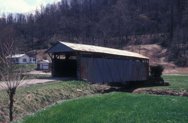
Photo: Jerrye and Roy Klotz, MD, CC BY-SA 3.0 · Wikimedia Commons
Local history sources: en.wikipedia.org · en.wikipedia.org · en.wikipedia.org · commons.wikimedia.org · en.wikipedia.org · archive.org · archive.org
Historic places
1 place in Windsor Township, Lawrence County on the National Register of Historic Places. Press a pin or a name for its whole record.
-
Scottown Covered BridgeStructure · Scottown · listed 1975
- Address
- E of Scottown on SR 67
- Where
- Scottown, Lawrence County · ZIP 45678
- What it is
- Structure
- Listed on the National Register
- 1975
- NRIS reference number
- 75001456
- Coordinates
- 38.54785, -82.38011
National Register file (NPS) ↗ Search Wikipedia ↗ Street map and directions ↗ On the Cracked Buckeye map
Source: National Park Service, National Register of Historic Places point file. The listing year is shown where NPS's certification date agrees with the listing's reference number. Listing recognizes significance; it does not restrict a private owner.
Water
Mostly private wells The water here
- Hecla Water Association81% of residentsOhio River
- Aqua Ohio - Lawrence County17% of residentsOhio River (with Guyandotte River backup intake)
- Proctorville Village2% of residentsGroundwater wells (2 wells)
Hospitals, fire stations and more
Inside Windsor Township, Lawrence County's boundary: 1 fire or EMS station, 5 poor-rated bridges, 1 Superfund site and 4 spill cases. Press a pin or a name for its whole record and its source.
Fire and EMS stations (1)
-
Windsor Township Volunteer Fire DepartmentWillow Wood
- Address
- 8064 County Road 2, Willow Wood, OH 45696
- Coordinates
- 38.55190, -82.42612
USGS National Map structures (source) ↗ Street map and directions ↗
Source: USGS National Map structures (most Ohio records last updated 2019 to 2022), checked against the Columbus and Cleveland station lists. The department that answers a call is set by jurisdiction and mutual aid, not by distance.
Bridges rated poor (5)
-
Big Spring Road over Little Guyan CreekPoor · built 1900
- Condition
- Poor: a deck, superstructure, substructure or culvert rated 4 or below on the 0 to 9 scale
- What it is
- Bridge
- Built
- 1900
- Length
- 10 ft
- Owner
- County
- Vehicles a day
- 96
- Coordinates
- 38.56925, -82.38215
National Bridge Inventory (source) ↗ Street map and directions ↗
-
Farm Drive over Little Guyan CreekPoor · built 1991
- Condition
- Poor: a deck, superstructure, substructure or culvert rated 4 or below on the 0 to 9 scale
- What it is
- Bridge
- Built
- 1991
- Length
- 8 ft
- Owner
- County
- Vehicles a day
- 746
- Coordinates
- 38.56380, -82.38262
National Bridge Inventory (source) ↗ Street map and directions ↗
-
Scottown Lecta Rd over Br of Indian Guyan CreekPoor · built 1995
- Condition
- Poor: a deck, superstructure, substructure or culvert rated 4 or below on the 0 to 9 scale
- What it is
- Bridge
- Built
- 1995
- Length
- 8 ft
- Owner
- County
- Vehicles a day
- 274
- Coordinates
- 38.58407, -82.37407
National Bridge Inventory (source) ↗ Street map and directions ↗
-
Township Road 229 over Mckinney CreekPoor · built 1992
- Condition
- Poor: a deck, superstructure, substructure or culvert rated 4 or below on the 0 to 9 scale
- What it is
- Bridge
- Built
- 1992
- Length
- 8 ft
- Owner
- County
- Vehicles a day
- 209
- Coordinates
- 38.50612, -82.44889
National Bridge Inventory (source) ↗ Street map and directions ↗
-
Yellow Creek Rd over Yellow CreekPoor · built 1935
- Condition
- Poor: a deck, superstructure, substructure or culvert rated 4 or below on the 0 to 9 scale
- What it is
- Bridge
- Built
- 1935
- Length
- 12 ft
- Owner
- County
- Vehicles a day
- 209
- Coordinates
- 38.56178, -82.47852
National Bridge Inventory (source) ↗ Street map and directions ↗
Source: FHWA National Bridge Inventory 2025. "Poor" means one major part rated 4 or below on the 0 to 9 scale; it calls for repair, not closing, unless the state posts or closes the bridge.
Superfund sites (1)
-
Chesapeake MercurySuperfund program · Chesapeake
- Address
- 1705 Township Road 170, Chesapeake, OH 45619
- County
- Lawrence County
- Status
- Superfund program site, not on the National Priorities List
- EPA program ID
- OHN000505538
- EPA registry ID
- 110067036068
EPA facility record ↗ EPA Facility Registry Service (source) ↗ Street map and directions ↗
Source: EPA Facility Registry Service, Superfund (SEMS) and National Priorities List sites. Many program sites were assessed and needed no cleanup.
Spills reported since 2021 (4)
-
Sewage Human2025-01-18 · Windsor Twp
- Reported
- 2025-01-18
- What spilled
- Sewage Human
- Where
- Windsor Twp, Lawrence County
- Ohio EPA district office
- SEDO
- Ohio EPA case number
- 2501EPA0000068
Ohio EPA spill reports (source) ↗ Street map and directions ↗
-
Fuel Diesel / Diesel Fuel (Vehicle On Or Off Road) Reached water2024-01-30 · Windsor Twp
- Reported
- 2024-01-30
- What spilled
- Fuel Diesel / Diesel Fuel (Vehicle On Or Off Road)
- Largest amount reported
- 50 gallons
- Reached a waterway
- 99 - Unnamed
- Where
- Windsor Twp, Lawrence County
- Ohio EPA district office
- SEDO
- Ohio EPA case number
- 2401EPA0000160
Ohio EPA spill reports (source) ↗ Street map and directions ↗
-
Oil Motor / Lube Oil / Vehicle2023-04-19 · Windsor Twp
- Reported
- 2023-04-19
- What spilled
- Oil Motor / Lube Oil / Vehicle
- Where
- Windsor Twp, Lawrence County
- Ohio EPA district office
- SEDO
- Ohio EPA case number
- 2304EPA0000620
Ohio EPA spill reports (source) ↗ Street map and directions ↗
-
Sewage Human Reached water2023-02-28 · Windsor Twp
- Reported
- 2023-02-28
- What spilled
- Sewage Human
- Reached a waterway
- 44 - Indian Guyan Creek
- Where
- Windsor Twp, Lawrence County
- Ohio EPA district office
- SEDO
- Ohio EPA case number
- 2302EPA0000306
Ohio EPA spill reports (source) ↗ Street map and directions ↗
Source: Ohio EPA emergency response spill reports, 2021 to September 2026, one point per case where Ohio EPA placed it. A report is what the caller or responder recorded; amounts are often blank or estimated.
Its ZIP codes
Each ZIP code that touches Windsor Township, Lawrence County, with the share of its residents who live here and the same headline figures as the ZIP page.
Local government
Who holds office in Windsor Township, Lawrence County, how its elections and ballot issues came out, and the state auditor's record.
Money issues on the ballot since 2024: 1 of 1 passed.
Ballot issues
| Date | Issue | For | Against | Result |
|---|---|---|---|---|
| 2024-03-19 | Issue: Windsor Township Tax Levy Fire | 223 | 87 | Passed (71.94% for) |
Elections for office
| Date | Office | Candidates and votes |
|---|---|---|
| 2021-11-02 | Township Trustee | Robert E. Burcham 232, 29.94%; Larry Delawder 118, 15.23%; Nick Catalogna 174, 22.45%; Norman R. Humphrey II 251, 32.39% |
| 2019-11-05 | Township Trustee | Donald Rigney 427, 100.0% |
| 2019-11-05 | Township Fiscal Officer | Carrie Cheek 135, 27.16%; Hazel Payne Humphrey 362, 72.84% |
Winners in bold. Results from the county board of elections' official canvass unless marked.
Auditor of State record
- No fiscal caution, watch or emergency on the Auditor of State's lists.
- Agreed Upon Procedures, 2022 to 2023, released 2026-02-12
The county
Lawrence County: 9 ZIP codes, 20 cities, villages and townships, 58,180 people.
Nearby places
Quick answers
What county is Windsor Township, Ohio in?
Windsor Township, Lawrence County is a township in Lawrence County, Ohio, with 2,027 residents.
When was Windsor Township, Ohio founded?
Windsor Township, Lawrence County was incorporated by 1840 (first appears in the county's 1840 census; organization date not found). Source
What ZIP code is Windsor Township, Ohio?
Windsor Township, Lawrence County is served by ZIP codes 45678, 45696, 45619, 45669 and 45645; 45678 holds the largest share of its residents.
Where does Windsor Township, Ohio get its water?
The main water source for Windsor Township, Lawrence County (Hecla Water Association): Mostly private wells.
Cite this page
Cite this page as:
Cracked Buckeye, "Windsor Township, Lawrence County", https://crackedbuckeye.com/place/windsor-township-lawrence-county/, built 2026-10-31, accessed [date].
How to cite · Report a correction · Built 2026-10-31