Local events in Chesapeake
Nothing is posted yet for this village in the calendars we watch. What we watch, and what is on nearby
Know a calendar we should watch? Send the link
Checked October 20; the events page is refreshed daily.
How Chesapeake began
Chesapeake sits in Union Township on the Ohio River's northern bank at its confluence with Symmes Creek, directly across from Huntington, West Virginia, and connected to it by the Robert C. Byrd Bridge. Its name is Algonquian in origin, though sources disagree on the exact meaning. The village peaked at 1,396 residents in 1960 and has since declined to 765.
Incorporated Between 1900 and 1910 (absent from the 1900 census table, 541 residents in 1910).
Where the name comes from
Ultimately an Algonquian word, though its exact meaning is disputed even for its origin point, Chesapeake Bay in Virginia: one summary of the Ohio village's own name calls it a term meaning "place where water is spread out," while linguist Blair Rudes's 2005 study of the Virginia bay's name concluded it more likely meant "great water" or referred to a village at the bay's mouth, and specifically rejected the popular claim that it meant "great shellfish bay."
Before the town
No source found records a Native village, mound, trail, or treaty event specific to Chesapeake, Ohio itself, though the village's name is Algonquian, borrowed from Chesapeake Bay in Virginia rather than reflecting a local Ohio place name. The village lies within the Ohio River lands ceded at the 1795 Treaty of Greenville; the county's broader Native history is covered at the county level.
Nations recorded here: Shawnee.
Timeline
- — Joel Gillett plants the orchard that produces the Rome Beauty apple in the Quaker Bottom, about two miles above Proctorville in what is now Union Township, the township in which Chesapeake lies.
- — The village of Chesapeake is created; the 1900 census table of the 1916 history does not list it, and it appears in 1910 with 541 residents.
- — The Chesapeake Village jail comes into use; it stays in use until 1961.
- — A flood damages low sections of Chesapeake and other Ohio River towns.
- — The county history calls Chesapeake, in Union Township, about the same size as Proctorville (nearly 600 people).
- — Population grows from 821 to 1,094.
- — On May 7, the first air mail flown direct from the Ironton Post Office lands at the Chesapeake airport, the earliest recorded air link between Ironton and Chesapeake.
- — The village's population peaks at 1,396 residents.
- — The village's steepest population decline occurs, falling from 1,370 to 842 residents.
- — The village's population is recorded at 765 residents.
Stories
A village that appears between two censuses
The 1916 county history prints a township table in which Union Township, with Proctorville, had 3,087 people in 1900 and 3,563 in 1910, and where Chesapeake Village has no figure for 1900 and 541 for 1910. The text explains that the township's gain was due partly to the fact that 'Chesapeake Village in Union Township has been created.' By 1916 the historian called it about the same size as Proctorville, nearly six hundred people, one of three incorporated villages in the southeast corner of the county. The village jail went into use in 1910 and stayed in use until 1961. The village then grew to 1,396 by 1960 and has declined since 1980 to 765 in 2020.
Photographs
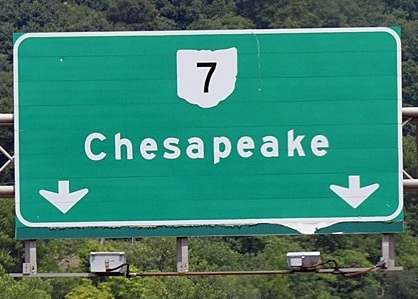
Photo: Andreas Faessler, CC BY-SA 4.0 · Wikimedia Commons
Local history sources: en.wikipedia.org · en.wikipedia.org · en.wikipedia.org · commons.wikimedia.org · en.wikipedia.org · archive.org · archive.org
Water
Ohio River surface water, treated at the Ironton Water Treatment Plant (built 1993, approved capacity 4 million gallons per day, about 1.3 MGD produced). The foot-of-Vernon-Street siting describes the original 1872 waterworks, not the current intake location. The water here
- Hecla Water Association57% of residentsOhio River
- Aqua Ohio - Lawrence County43% of residentsOhio River (with Guyandotte River backup intake)
Hospitals, fire stations and more
Inside Chesapeake's boundary: 1 health center, 1 fire or EMS station, 1 police station and 1 spill case. Press a pin or a name for its whole record and its source.
Community health centers (1)
-
Chesapeake Family Medical CenterHealth center · Chesapeake
- Run by
- a federally qualified health center
- Setting
- Clinic
- City
- Chesapeake
- Coordinates
- 38.42650, -82.46145
Find a Health Center (HRSA) ↗ HRSA data (source) ↗ Street map and directions ↗
Source: HRSA health center service delivery sites, active, September 2026 (school-based sites left out). Health centers see patients whether or not they have insurance, with fees on a sliding scale.
Fire and EMS stations (1)
-
Chesapeake - Union Township Volunteer Fire DepartmentChesapeake
- Address
- 400 Bridge Way, Chesapeake, OH 45619
- Coordinates
- 38.42966, -82.45751
USGS National Map structures (source) ↗ Street map and directions ↗
Source: USGS National Map structures (most Ohio records last updated 2019 to 2022), checked against the Columbus and Cleveland station lists. The department that answers a call is set by jurisdiction and mutual aid, not by distance.
Police stations (1)
-
Chesapeake Police DepartmentChesapeake
- Address
- 211 Third Avenue, Chesapeake, OH 45619
- Coordinates
- 38.42858, -82.45345
Where this record comes from ↗ USGS National Map structures (source) ↗ Street map and directions ↗
Source: USGS National Map structures, police stations, corrected and completed by hand (September 2026). The department that answers a call is set by jurisdiction, not by distance.
Spills reported since 2021 (1)
-
Other / All Other / Trade Name / Mixture / Solution Etc2025-10-13 · Chesapeake
- Reported
- 2025-10-13
- What spilled
- Other / All Other / Trade Name / Mixture / Solution Etc
- Where
- Chesapeake, Lawrence County
- Ohio EPA district office
- SEDO
- Ohio EPA case number
- 2510EPA0001687
Ohio EPA spill reports (source) ↗ Street map and directions ↗
Source: Ohio EPA emergency response spill reports, 2021 to September 2026, one point per case where Ohio EPA placed it. A report is what the caller or responder recorded; amounts are often blank or estimated.
Its ZIP codes
Each ZIP code that touches Chesapeake, with the share of its residents who live here and the same headline figures as the ZIP page.
| ZIP | Share | Water | Radon | Home value | Schools | Flood |
|---|---|---|---|---|---|---|
| 45619 Union Township and Chesapeake | 10% | Ohio River surface water, treated at the Ironton Water Treatment Plant (built 1993, approved capacity 4 million gallons per day, about 1.3 MGD produced). The foot-of-Vernon-Street siting describes the original 1872 waterworks, not the current intake location. | 3.5 pCi/L average radon | Median year built 1974 | Chesapeake Union Exempted Village · 4 stars overall | 18% of residents in the 1% floodplain |
Local government
Who holds office in Chesapeake, how its elections and ballot issues came out, and the state auditor's record.
Money issues on the ballot since 2019: 2 of 2 passed.
Ballot issues
| Date | Issue | For | Against | Result |
|---|---|---|---|---|
| 2021-11-02 | Issue: Chesapeake Village Tax Levy Police | 56 | 42 | Passed (57.14% for) |
| 2019-11-05 | Issue: Chesapeake Village Tax Levy Fire | 122 | 73 | Passed (62.56% for) |
Elections for office
| Date | Office | Candidates and votes |
|---|---|---|
| 2021-11-02 | Member of Council | Lisa Blake 57, 25.56%; Drew Griffin 55, 24.66%; Nathan Ittig 48, 21.52%; Jacob Wells 63, 28.25% |
| 2019-11-05 | Member of Council | Paul Hart 132, 42.31%; Randy Penix 68, 21.79%; Kenneth W. Wolfe 112, 35.9% |
| 2019-11-05 | Mayor | Micheal D. Ferguson 39, 19.7%; Kimberly Oldaker 81, 40.91%; Tommy Templeton 78, 39.39% |
Winners in bold. Results from the county board of elections' official canvass unless marked.
Auditor of State record
- No fiscal caution, watch or emergency on the Auditor of State's lists.
- Financial Audit, 2023 to 2024, released 2026-02-17
- Financial Audit, 2019 to 2022, released 2025-06-10
The county
Lawrence County: 9 ZIP codes, 20 cities, villages and townships, 58,180 people.
Nearby places
Rain and snow
How much has actually fallen on Chesapeake, day by day, from 1887 to now. Daily totals, not averages.
- rain, last 30 days
- 2.64 in
- 2026-09-30 to 2026-10-29
- rain so far in 2026
- 31.7 in
- 8.0 in below normal for the date
- snow so far in 2026
- 7.4 in
- a normal year brings 13.2 in
- a normal year
- 46.9 in
- average of 30 years, 1991-2020
| Month | Rain (in) | Snow (in) | Days counted |
|---|---|---|---|
| October 2026 | 2.64 | — | 29 |
| September 2026 | 2.98 | — | 30 |
| August 2026 | 3.51 | — | 31 |
| July 2026 | 5.39 | — | 31 |
| June 2026 | 2.64 | — | 30 |
| May 2026 | 5.32 | — | 31 |
| April 2026 | 2.41 | — | 30 |
| March 2026 | 3.08 | 1.9 | 31 |
| February 2026 | 1.31 | 4.0 | 28 |
| January 2026 | 2.40 | 1.5 | 31 |
| December 2025 | 1.89 | 6.2 | 31 |
| November 2025 | 4.33 | 0.4 | 30 |
| Wettest year | 2011 — 63.3 in |
|---|---|
| Driest year | 1930 — 22.5 in |
| Snowiest year | 1917 — 51.2 in |
| Wettest day on record | 16 August 1905 — 4.37 in |
| Heaviest snowfall in a day | 27 February 1906 — 12.92 in |
| Deepest snow on the ground | 20 January 1978 — 17.60 in |
Estimated, not measured. No rain gauge has ever stood inside Chesapeake, so every figure here is worked out from the gauges around it - the nearest ones weighted most. Treat them as close estimates rather than readings.
50,401 days of records, 1887-07-01 to 2026-10-29. Source: NOAA NCEI GHCN-Daily, 3,240 gauges in and around Ohio. A day is "gauged" when a gauge standing inside the boundary reported it, and the value is the mean of those gauges. Otherwise it is interpolated by inverse distance from every gauge reporting within 50 miles. Nothing is carried forward, back-filled or smoothed. Against NOAA nClimDiv county monthly precipitation over 136,848 complete county-months (checked 2026-10-31): correlation 0.9515, median absolute difference 0.217 in a month. Built 2026-10-31 from the Cracked Buckeye precipitation archive. Snow is the softer number — snowfall is measured by hand with a ruler, no agency publishes a gridded county snowfall series, and blowing snow defeats every observer.
Environmental permits and filings
What Ohio EPA has on file for Chesapeake: permits, inspections, violations, cleanups and the state loans behind sewer and water work. Every line links to the agency's own document.
- facilities and sites on file
- 3
- those placed on the map inside Chesapeake
| Program | Facilities and sites |
|---|---|
| Hazardous waste | 3 |
| Date | Facility or site | What |
|---|---|---|
| KEITH'S AUTO REPAIR | Hazardous waste notice of violation | |
| KEITH'S AUTO REPAIR | Hazardous waste notice of violation |
Source: Ohio EPA eDocument portal (edocpub.epa.ohio.gov), indexed 2026-10-14. Facilities are placed on the map from Ohio EPA's own map layers, EPA's Facility Registry, coordinates written in the filings, or a geocoded street address. A permit filed under a private person's name (most are household septic systems) is counted but never named, placed or linked; licenses for individual workers and open-burning notices are left out entirely.
Quick answers
What county is Chesapeake, Ohio in?
Chesapeake is a village in Lawrence County, Ohio, with 765 residents.
When was Chesapeake, Ohio founded?
Chesapeake was incorporated Between 1900 and 1910 (absent from the 1900 census table, 541 residents in 1910). Source
How did Chesapeake, Ohio get its name?
Ultimately an Algonquian word, though its exact meaning is disputed even for its origin point, Chesapeake Bay in Virginia: one summary of the Ohio village's own name calls it a term meaning "place where water is spread out," while linguist Blair Rudes's 2005 study of the Virginia bay's name concluded it more likely meant "great water" or referred to a village at the bay's mouth, and specifically rejected the popular claim that it meant "great shellfish bay." Source
What ZIP code is Chesapeake, Ohio?
Most of Chesapeake is in ZIP code 45619.
Where does Chesapeake, Ohio get its water?
The main water source for Chesapeake (Hecla Water Association): Ohio River surface water, treated at the Ironton Water Treatment Plant (built 1993, approved capacity 4 million gallons per day, about 1.3 MGD produced). The foot-of-Vernon-Street siting describes the original 1872 waterworks, not the current intake location.
Cite this page
Cite this page as:
Cracked Buckeye, "Chesapeake, Lawrence County", https://crackedbuckeye.com/place/chesapeake/, built 2026-10-31, accessed [date].
How to cite · Report a correction · Built 2026-10-31
