Local events in Whitehouse
Whitehouse itself has 8 events posted in the next 90 days; the others here are within 10 miles. All local events in Whitehouse
Checked October 20; the events page is refreshed daily.
Deep dives about Whitehouse
Long reads built from maps, newspapers and public records. All deep dives
How Whitehouse began
Whitehouse grew up in the northwest of Waterville Township on land first entered by Harvey Kembar in 1842 and conveyed in 1855 to Edward Whitehouse of New York, a director of the Wabash Railroad (the village's own history calls him its treasurer), for whom the village is named. A neighborhood center had formed before the railroad, with a Methodist Protestant church organized in 1846, and the Wabash line, completed in 1855, made it a station; a post office opened in 1858 (1856 per Wikipedia), the plat was recorded July 5, 1864, and the village was incorporated in 1867. Limestone quarries opened east of the village from 1860 became its main industry, shipping railroad ballast and foundation stone to Toledo. The village had 554 residents in 1880 and 513 in 1920, then grew with Toledo's suburbs to 4,990 by 2020.
Settled neighborhood center before 1846; land first entered by Harvey Kembar, October 6, 1842, platted plat recorded July 5, 1864 (Killits gives June 20, 1854), incorporated 1867, by John R. Osborn and Edward Whitehouse.
Where the name comes from
The village bears the name of Edward Whitehouse of New York, who bought the site in September 1855 while a director of the Wabash Railroad (Waggoner) and whom the village's own history calls the railroad's treasurer; with his wife and John Osborn he donated the land for the village green, now Whitehouse Village Park.
Before the town
The village's own history and Wikipedia state that the area was used by the Miami, Odawa (Ottawa), Shawnee, Wyandot and Lenape (Delaware), and the village history records that Native travelers used the route of present Weckerly Road between Fort Malden and Kentucky. Waggoner (1888) describes the main road through Waterville Township as the old trail from the Wapakoneta hunting grounds to Fort Malden. No village, camp or mound inside Whitehouse's limits is named in the sources.
Nations recorded here: Miami, Odawa (Ottawa), Shawnee, Wyandot, Lenape (Delaware).
- Weckerly Road trail (trail) — line of present Weckerly Road, Whitehouse area, before and during early settlement (whitehouseoh.gov)
Timeline
- — General Anthony Wayne's victory at the Battle of Fallen Timbers, a few miles east, opens the area to American settlement.
- — Harvey Kembar enters the land on which Whitehouse stands; it passes to James Craven in 1850 and to John R. Osborn in 1855.
- — A Methodist Protestant church is organized with Rev. John Foster as first pastor.
- — The Wabash Railroad is completed through the site, and in September the land is conveyed to Edward Whitehouse, a director of the railroad (or, by the village's own history, its treasurer).
- — A post office opens at the future Whitehouse.
- — Alexander Walp is appointed postmaster, A. J. Eldridge opens a general store and Michael Goodman a blacksmith shop (Wikipedia dates the post office 1856).
- — John Williams and A. Walp open the first Whitehouse quarry on the land of J. E. Hall; the Osborn quarry follows in 1865 and the Brogan quarry in 1868.
- — The plat of Whitehouse, laid out by John Osborn, is recorded (Killits gives June 20, 1854).
- — Whitehouse is incorporated as a village.
- — The Methodist Protestants build a house of worship costing $1,800.
- — John Stoker builds the Stoker House, the first hotel.
- — A brick and stone schoolhouse costing $8,000 replaces a frame school destroyed by fire.
- — Whitehouse's population stands at 554.
- — The Whitehouse Pythian Castle is built at 6761 Providence Street.
- — The Civil War statue in the village park is dedicated; it is restored in 1979.
- — The Whitehouse State Savings Bank is established.
- — Whitehouse has 513 residents.
- — A log house built in the 1840s is found under siding during demolition near State Route 64 and Shepler Street; it is moved to village land, and the Whitehouse Historical Society is formed in 1970 to restore it.
- — The Norfolk & Western abandons the old Wabash track between Maumee and Whitehouse and on to Liberty Center; the right of way becomes the Wabash Cannonball Trail.
- — Whitehouse's population grows 51.8 percent as Toledo-area suburban development reaches the village.
- — Whitehouse abandons its village well system and connects to the Lucas County Water System, which in turn contracts with Toledo for supply.
- — The village's population reaches 4,990.
Stories
A railroad man's name on a farm village
Whitehouse was a farm neighborhood with a Methodist Protestant congregation before it was a town. The land was first entered in 1842, and in 1853 the Toledo and Illinois Railroad, soon consolidated into the Wabash, began building through the Maumee Valley. In September 1855 the site was conveyed to Edward Whitehouse of New York, a Wabash director (the village's history says treasurer), and the village took his name when John Osborn's plat was recorded in 1864. Whitehouse, his wife and Osborn gave the land for the village green, now Whitehouse Village Park. The village counted 554 residents in 1880 and 513 in 1920, and grew rapidly only after 1990, reaching 4,990 by 2020.
The Whitehouse quarries
Stone had been quarried in Waterville Township since the Miami and Erie Canal was built, but the largest workings were east of Whitehouse. John Williams and A. Walp opened a quarry on J. E. Hall's land in 1860; N. O. Hall and Walp ran it from 1870, and merchants J. L. Pray and J. E. Hall took it over in 1876. By 1888 Pray alone worked a pit about a mile long and 60 rods wide, with steam power and a mile of track connecting to the Wabash, and the railroad as far west as the Mississippi had been ballasted largely with Whitehouse stone. The Osborn quarry, opened in 1865 and worked from 1875 by John Ryan for ballast and road metal, and the Brogan quarry, opened in 1868, lay nearby. Together they employed 40 men and supplied foundation stone for Toledo's principal buildings and the new state hospital near Toledo. The village's own history adds that the quarry opened in 1860 was later filled with water and used by residents as a swimming hole.
Photographs
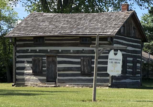
Photo: Mbrickn, CC BY 4.0 · Wikimedia Commons
Local history sources: en.wikipedia.org · commons.wikimedia.org · whitehouseoh.gov · archive.org · archive.org · archive.org · archive.org · archive.org
Water
Lake Erie, intake crib roughly 3 miles offshore of the Collins Park plant in Maumee Bay near Oregon, OH The water here
- Whitehouse Village94% of residentsLake Erie
- Toledo City Of6% of residentsLake Erie
Hospitals, fire stations and more
Inside Whitehouse's boundary: 1 nursing home, 1 fire or EMS station, 4 public schools, 1 police station, 1 Superfund site, 1 Toxics Release Inventory facility and 6 spill cases. Press a pin or a name for its whole record and its source.
Nursing homes (1)
-
Whitehouse Country Manor4 of 5 stars · Whitehouse
- Address
- 11239 Waterville St, Whitehouse, OH 43571
- Certified beds
- 90
- Residents on an average day
- 86
- Medicare overall rating
- 4 of 5 stars
- Health inspections
- 3 of 5 stars
- Staffing
- 2 of 5 stars
- Quality measures
- 5 of 5 stars
- Penalties since 2023
- none
- Ownership
- For profit - Corporation
- Chain
- HILLSTONE HEALTHCARE
- Takes
- Medicare and Medicaid
- Phone
- (419) 877-5338
- Medicare ID
- 365756
Medicare Care Compare ↗ CMS nursing home data (source) ↗ Street map and directions ↗
Source: CMS Care Compare nursing home provider and penalties files; Medicare star ratings run 1 to 5.
Fire and EMS stations (1)
-
Whitehouse Fire DepartmentWhitehouse
- Address
- 10550 Waterville Street, Whitehouse, OH 43571
- Coordinates
- 41.51722, -83.79509
USGS National Map structures (source) ↗ Street map and directions ↗
Source: USGS National Map structures (most Ohio records last updated 2019 to 2022), checked against the Columbus and Cleveland station lists. The department that answers a call is set by jurisdiction and mutual aid, not by distance.
Public schools (4)
-
Anthony Wayne High School4.5 of 5 stars · Whitehouse
- Address
- 5967 Finzel Rd, Whitehouse, OH 43571
- School district
- Anthony Wayne Local School District
- Kind (NCES)
- Regular School
- Students, 2023-24
- 1,335
- Teachers (full-time equivalent)
- 54
- Report card, 2025-26
- 4.5 of 5 stars
- Performance index
- 90.4%
- Four-year graduation rate
- 97.5%
- Ohio building IRN
- 000810
- NCES school ID
- 390482003144
NCES school record ↗ Ohio School Report Card ↗ Street map and directions ↗
-
Anthony Wayne Junior High School4 of 5 stars · Whitehouse
- Address
- 6035 Finzel Rd, Whitehouse, OH 43571
- School district
- Anthony Wayne Local School District
- Kind (NCES)
- Regular School
- Students, 2023-24
- 685
- Teachers (full-time equivalent)
- 33
- Report card, 2025-26
- 4 of 5 stars
- Performance index
- 93.1%
- Ohio building IRN
- 125229
- NCES school ID
- 390482000849
NCES school record ↗ Ohio School Report Card ↗ Street map and directions ↗
-
Fallen Timbers Middle School5 of 5 stars · Whitehouse
- Address
- 6119 Finzel Rd, Whitehouse, OH 43571
- School district
- Anthony Wayne Local School District
- Kind (NCES)
- Regular School
- Students, 2023-24
- 678
- Teachers (full-time equivalent)
- 39
- Report card, 2025-26
- 5 of 5 stars
- Performance index
- 97%
- Ohio building IRN
- 011346
- NCES school ID
- 390482003145
NCES school record ↗ Ohio School Report Card ↗ Street map and directions ↗
-
Whitehouse Primary School4 of 5 stars · Whitehouse
- Address
- 6510 Texas St, Whitehouse, OH 43571
- School district
- Anthony Wayne Local School District
- Kind (NCES)
- Regular School
- Students, 2023-24
- 517
- Teachers (full-time equivalent)
- 27
- Report card, 2025-26
- 4 of 5 stars
- Performance index
- 101.5%
- Ohio building IRN
- 041038
- NCES school ID
- 390482003148
NCES school record ↗ Ohio School Report Card ↗ Street map and directions ↗
Source: NCES EDGE public school locations 2024-25 and Common Core of Data 2023-24 (type, students, teachers); Ohio School Report Cards 2025-26 (Department of Education and Workforce), matched by name within the district.
Police stations (1)
-
Whitehouse Police DepartmentWhitehouse
- Address
- 6925 Providence Street, Whitehouse, OH 43571
- Coordinates
- 41.51432, -83.80206
USGS National Map structures (source) ↗ Street map and directions ↗
Source: USGS National Map structures, police stations, corrected and completed by hand (September 2026). The department that answers a call is set by jurisdiction, not by distance.
Superfund sites (1)
-
Whitehouse Industrial SpillSuperfund program · Whitehouse
- Address
- 10444 Waterville St, Whitehouse, OH 43571
- County
- -- Not Defined -- County
- Status
- Superfund program site, not on the National Priorities List
- EPA program ID
- OHN000522150
- EPA registry ID
- 110071907619
EPA facility record ↗ EPA Facility Registry Service (source) ↗ Street map and directions ↗
Source: EPA Facility Registry Service, Superfund (SEMS) and National Priorities List sites. Many program sites were assessed and needed no cleanup.
Facilities reporting toxic releases (1)
-
Ardagh Metal Packaging Usa CorpToxics Release Inventory · Whitehouse
- Address
- 10444 Waterville St, Whitehouse, OH 43571
- County
- Lucas County
- Status
- Reports to the Toxics Release Inventory (open)
- EPA program ID
- 43571MRCNN10444
- EPA registry ID
- 110000500057
EPA facility record ↗ EPA Facility Registry Service (source) ↗ Street map and directions ↗
Source: EPA Facility Registry Service, Toxics Release Inventory reporters. Reporting a release is required of large users of listed chemicals; it is not by itself a violation.
Spills reported since 2021 (6)
-
Fuel Diesel / Diesel Fuel (Vehicle On Or Off Road)2025-07-12 · Whitehouse
- Reported
- 2025-07-12
- What spilled
- Fuel Diesel / Diesel Fuel (Vehicle On Or Off Road)
- Where
- Whitehouse, Lucas County
- Ohio EPA district office
- NWDO
- Ohio EPA case number
- 2507EPA0001160
Ohio EPA spill reports (source) ↗ Street map and directions ↗
-
Material Unknown Reached water2025-03-31 · Whitehouse
- Reported
- 2025-03-31
- What spilled
- Material Unknown
- Reached a waterway
- 99 - Unnamed
- Where
- Whitehouse, Lucas County
- Ohio EPA district office
- NWDO
- Ohio EPA case number
- 2503EPA0000464
Ohio EPA spill reports (source) ↗ Street map and directions ↗
-
Oil Hydraulic Fluid(S)2025-03-06 · Whitehouse
- Reported
- 2025-03-06
- What spilled
- Oil Hydraulic Fluid(S)
- Largest amount reported
- 2,000 gallons
- Where
- Whitehouse, Lucas County
- Ohio EPA district office
- NWDO
- Ohio EPA case number
- 2503EPA0000311
Ohio EPA spill reports (source) ↗ Street map and directions ↗
-
Fuel Diesel / Diesel Fuel (Vehicle On Or Off Road) Reached water2025-03-06 · Whitehouse
- Reported
- 2025-03-06
- What spilled
- Fuel Diesel / Diesel Fuel (Vehicle On Or Off Road)
- Reached a waterway
- 48 - Blue Creek
- Where
- Whitehouse, Lucas County
- Ohio EPA district office
- NWDO
- Ohio EPA case number
- 2503EPA0000310
Ohio EPA spill reports (source) ↗ Street map and directions ↗
-
Nitric Acid (Hno3)2021-04-22 · Whitehouse
- Reported
- 2021-04-22
- What spilled
- Nitric Acid (Hno3)
- Largest amount reported
- 300 gallons
- Where
- Whitehouse, Lucas County
- Ohio EPA district office
- NWDO
- Ohio EPA case number
- 2104EPA0000552
Ohio EPA spill reports (source) ↗ Street map and directions ↗
-
Oil Hydraulic Fluid(S)2021-01-31 · Whitehouse
- Reported
- 2021-01-31
- What spilled
- Oil Hydraulic Fluid(S)
- Largest amount reported
- 10 gallons
- Where
- Whitehouse, Lucas County
- Ohio EPA district office
- NWDO
- Ohio EPA case number
- 2101EPA0000140
Ohio EPA spill reports (source) ↗ Street map and directions ↗
Source: Ohio EPA emergency response spill reports, 2021 to September 2026, one point per case where Ohio EPA placed it. A report is what the caller or responder recorded; amounts are often blank or estimated.
Its ZIP codes
Each ZIP code that touches Whitehouse, with the share of its residents who live here and the same headline figures as the ZIP page.
| ZIP | Share | Water | Radon | Home value | Schools | Flood |
|---|---|---|---|---|---|---|
| 43571 Whitehouse | 64% | Lake Erie, intake crib roughly 3 miles offshore of the Collins Park plant in Maumee Bay near Oregon, OH | 4.2 pCi/L average radon | Median year built 1991 | Anthony Wayne Local · 4.5 stars overall | 3.0% of residents in the 1% floodplain |
Local government
Who holds office in Whitehouse, how its elections and ballot issues came out, and the state auditor's record.
Auditor of State record
- No fiscal caution, watch or emergency on the Auditor of State's lists.
- Financial Audit, 2025, released 2026-09-01
- Financial Audit, 2023 to 2024, released 2025-12-04
The county
Lucas County: 26 ZIP codes, 20 cities, villages and townships, 427,372 people.
Nearby places
Rain and snow
How much has actually fallen on Whitehouse, day by day, from 1871 to now. Daily totals, not averages.
- rain, last 30 days
- 2.06 in
- 2026-09-30 to 2026-10-29
- rain so far in 2026
- 33.2 in
- 3.1 in above normal for the date
- snow so far in 2026
- 16.9 in
- a normal year brings 34.0 in
- a normal year
- 35.3 in
- average of 30 years, 1991-2020
| Month | Rain (in) | Snow (in) | Days counted |
|---|---|---|---|
| October 2026 | 2.05 | — | 29 |
| September 2026 | 3.22 | — | 30 |
| August 2026 | 5.10 | — | 31 |
| July 2026 | 3.37 | — | 31 |
| June 2026 | 3.89 | — | 30 |
| May 2026 | 2.19 | — | 31 |
| April 2026 | 6.82 | — | 30 |
| March 2026 | 4.67 | 0.1 | 31 |
| February 2026 | 0.69 | 2.8 | 28 |
| January 2026 | 1.18 | 14.0 | 31 |
| December 2025 | 1.72 | 7.1 | 31 |
| November 2025 | 1.83 | 5.6 | 30 |
| Wettest year | 1950 — 50.8 in |
|---|---|
| Driest year | 1963 — 21.8 in |
| Snowiest year | 2014 — 77.5 in |
| Wettest day on record | 4 July 1969 — 3.38 in |
| Heaviest snowfall in a day | 28 February 1900 — 13.85 in |
| Deepest snow on the ground | 6 February 1978 — 18.89 in |
Estimated, not measured. No rain gauge has ever stood inside Whitehouse, so every figure here is worked out from the gauges around it - the nearest ones weighted most. Treat them as close estimates rather than readings.
56,915 days of records, 1871-01-01 to 2026-10-29. Source: NOAA NCEI GHCN-Daily, 3,240 gauges in and around Ohio. A day is "gauged" when a gauge standing inside the boundary reported it, and the value is the mean of those gauges. Otherwise it is interpolated by inverse distance from every gauge reporting within 50 miles. Nothing is carried forward, back-filled or smoothed. Against NOAA nClimDiv county monthly precipitation over 136,848 complete county-months (checked 2026-10-31): correlation 0.9515, median absolute difference 0.217 in a month. Built 2026-10-31 from the Cracked Buckeye precipitation archive. Snow is the softer number — snowfall is measured by hand with a ruler, no agency publishes a gridded county snowfall series, and blowing snow defeats every observer.
Environmental permits and filings
What Ohio EPA has on file for Whitehouse: permits, inspections, violations, cleanups and the state loans behind sewer and water work. Every line links to the agency's own document.
- facilities and sites on file
- 25
- those placed on the map inside Whitehouse
| Program | Facilities and sites |
|---|---|
| Wastewater and stormwater discharge | 12 |
| Hazardous waste | 6 |
| State sewer loans | 2 |
| Air pollution | 1 |
| Cessation Of Regulated Operations | 1 |
| Public drinking water | 1 |
| State water loans | 1 |
| Wetland and stream fill | 1 |
| Date | Facility or site | What |
|---|---|---|
| FLYBAR | Hazardous waste violation resolved | |
| FLYBAR | Hazardous waste violation resolved | |
| WHITEHOUSE VILLAGE PWS | Public drinking water report | |
| BASF CORP COATINGS DIV | Hazardous waste inspection | |
| WHITEHOUSE PARK TRAIL | Wetland and stream fill permit | |
| PILLIOD | Wastewater and stormwater discharge permit | |
| WHITEHOUSE PARK TRAIL | Wetland and stream fill permit | |
| WHITEHOUSE VILLAGE PWS | Public drinking water plan | |
| WHITEHOUSE VILLAGE PWS | Public drinking water inspection | |
| SAVANNA LAKES | Wastewater and stormwater discharge permit | |
| FLYBAR | Hazardous waste notice of violation | |
| WHITEHOUSE VILLAGE PWS | Public drinking water inspection | |
| FLYBAR | Hazardous waste notice of violation | |
| WHITEHOUSE SQUARE TOWNHOMES | Wastewater and stormwater discharge permit | |
| TRADEWIND BUILDERS | Wastewater and stormwater discharge permit | |
| FLYBAR | Hazardous waste notice of violation | |
| WHITEHOUSE VILLAGE PWS | Public drinking water violation resolved | |
| WHITEHOUSE VILLAGE PWS | Public drinking water inspection | |
| WHITEHOUSE VILLAGE PWS | Public drinking water plan | |
| WHITEHOUSE VILLAGE PWS | Public drinking water violation resolved | |
| WHITEHOUSE VILLAGE PWS | Public drinking water notice of violation | |
| WHITEHOUSE VILLAGE PWS | Public drinking water notice of violation | |
| WHITEHOUSE VILLAGE PWS | Public drinking water plan | |
| THE PRESERVE PLAT II | Wastewater and stormwater discharge permit | |
| WHITEHOUSE VILLAGE PWS | Public drinking water compliance letter |
Source: Ohio EPA eDocument portal (edocpub.epa.ohio.gov), indexed 2026-10-14. Facilities are placed on the map from Ohio EPA's own map layers, EPA's Facility Registry, coordinates written in the filings, or a geocoded street address. A permit filed under a private person's name (most are household septic systems) is counted but never named, placed or linked; licenses for individual workers and open-burning notices are left out entirely.
Quick answers
What county is Whitehouse, Ohio in?
Whitehouse is a village in Lucas County, Ohio, with 4,990 residents.
When was Whitehouse, Ohio founded?
Whitehouse was settled neighborhood center before 1846; land first entered by Harvey Kembar, October 6, 1842; laid out plat recorded July 5, 1864 (Killits gives June 20, 1854); incorporated 1867. Founders on record: John R. Osborn and Edward Whitehouse. Source
How did Whitehouse, Ohio get its name?
The village bears the name of Edward Whitehouse of New York, who bought the site in September 1855 while a director of the Wabash Railroad (Waggoner) and whom the village's own history calls the railroad's treasurer; with his wife and John Osborn he donated the land for the village green, now Whitehouse Village Park. Source
What ZIP code is Whitehouse, Ohio?
Most of Whitehouse is in ZIP code 43571.
Where does Whitehouse, Ohio get its water?
The main water source for Whitehouse (Whitehouse Village): Lake Erie, intake crib roughly 3 miles offshore of the Collins Park plant in Maumee Bay near Oregon, OH.
Cite this page
Cite this page as:
Cracked Buckeye, "Whitehouse, Lucas County", https://crackedbuckeye.com/place/whitehouse/, built 2026-10-31, accessed [date].
How to cite · Report a correction · Built 2026-10-31
