How Thompson Township, Delaware County began
Thompson Township was organized June 5, 1820, named for an early government surveyor rather than a settler, and bounded on the east by the Scioto River, whose fords and mills shaped its earliest settlement. Samuel Weaver, arriving from Virginia by way of Chillicothe, built the first cabin around 1808-1809, and the township's small population grew slowly along the river at hamlets called Pickrell's Mills and Fairview before railroads bypassed them in favor of neighboring villages. It remains a rural, unincorporated township today, with no municipalities of its own, its best-documented landmark the Detwiller Tavern and Farmstead on State Route 257.
Settled 1808-1809 (Samuel Weaver), incorporated June 5, 1820, organized as a separate township, by petition granted by the Delaware County Commissioners.
Where the name comes from
The township is named, according to both the 1880 county history and Wikipedia, for an early government land surveyor named Thompson; neither source gives a first name or any further biography. The name was applied when the township organized in 1820 out of land earlier attached to the Virginia Military District.
Before the town
The 1880 county history ties two of the township's streams directly to Native names and, in one case, to a specific claimed identity. Tau Way Run, which flows into the Scioto near the site of the Methodist Episcopal Church, is said to be named for "an Indian tribe who, at an early date, occupied the banks of the river," which the source identifies as a band belonging to the Wyandot Nation, remembered as peaceable and friendly toward the whites; this identification comes from an 1880 county history and was not independently verified against other ethnographic sources, so it is reported here as a local tradition rather than a settled fact. Fulton's Creek carries a darker story: it was named for an early hunter, Fulton, who vanished into the woods near the stream around the 1810s and was never found, with some neighbors at the time suspecting Indians of killing him over jealousy of his hunting skill, though the source itself calls this only one of several competing theories, alongside the possibility he drowned in a swamp or quicksand. A separate incident, undated but placed "about 1820," describes Henry Swartz ordering a party of Indians off their traditional hunting ground on Fulton's Creek; when two of the Indians went missing soon afterward, their companions accused Swartz of killing and burning them, a charge the 1880 history says was never legally investigated and remained only a threat hanging over Swartz for the rest of his life. The township's original 1820 boundary description also names the "old Indian boundary line," the Greenville Treaty line, as its northern edge. Delaware County as a whole is named for the Lenape (Delaware) people; see the county file for the fuller regional and treaty record.
Nations recorded here: Wyandot, Lenape (Delaware).
Timeline
- — The Treaty of Greenville cedes the future township to the United States, with the treaty line running along what becomes its northern boundary.
- — Samuel Weaver, arriving from Virginia by way of Chillicothe, builds the first cabin in what becomes Thompson Township.
- — James Cochran, a Pennsylvania native, settles near Dilsaver's Ford and, about 1827, builds the township's first gristmill on Fulton's Creek.
- — John Swartz, an old Revolutionary War soldier, settles near what becomes Pickrell's Mills with his four sons.
- — Thompson is organized as a separate township on June 5, named for an early government surveyor.
- — Jacob Swartz builds the township's first sawmill on the west bank of the Scioto River, near the present Pickrell's Mills.
- — The formation of Morrow County takes part of Thompson's northern territory and gives it to Marion County.
- — The first bridge over the Scioto River within the township, a covered wooden bridge connecting to Radnor Township, is built; before this the only crossing was the ford known as Broad Ford.
- — H. P. Pickrell, formerly the miller at Ostrander, builds the large gristmill at the hamlet that comes to bear his name, Pickrell's Mills.
- — The John Detwiller Tavern and Farmstead, on State Route 257 west of Radnor, is listed on the National Register of Historic Places.
Stories
The Hunter Who Never Came Back
Fulton's Creek carries the name of a settler the 1880 county history calls one of the most successful hunters of his day, well liked by everyone, including the Indians who traded corn for meal at the little settlement near his cabin and always asked after "the great hunter" by name. One morning Fulton shouldered his rifle, waved to a trader watching from a shanty doorway, and walked into the forest along his favorite hunting ground near the creek that would take his name. He was never seen again. Neighbors tracked his trail to the water's edge before it vanished entirely, and searchers scoured the country for miles without finding a trace. The county history records three competing theories that circulated afterward: that Indians killed him out of envy for his hunting skill, that he left the settlement of his own accord, or that he simply sank in a swamp or bed of quicksand while chasing game. No explanation was ever confirmed, and the stream was named in his memory rather than his honor of discovery.
An Accusation Never Settled
Around 1820, a band of Indians came down from the north to hunt on Fulton's Creek, as they had customarily done, and Henry Swartz ordered them off the land. They answered, as the 1880 history records it, that although the land now belonged to the white man, the game still belonged to the Indian, and that as friends they should not be turned away. A few days later two of the party went missing; a search of the country turned up only evidence of bones where a fire had burned, and the group accused Swartz of killing and burning their companions. Swartz denied it, the matter was never legally investigated, and he reportedly lived out his life having to stay constantly on guard against retaliation. The county history itself notes only that some at the time suspected Swartz, with the help of a man named Williams, had in fact been responsible; the truth was never established either way.
Photographs
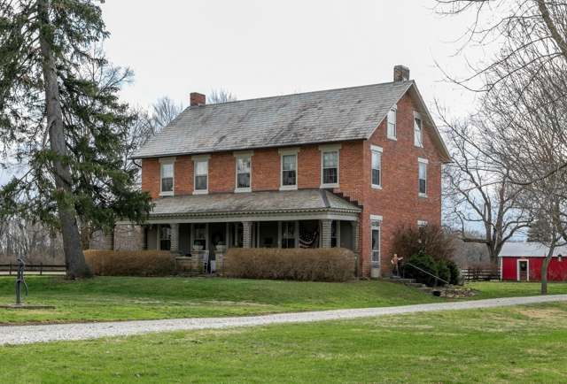
Photo: Christopher L. Riley, via Wikimedia Commons, CC BY-SA 4.0 · Wikimedia Commons
Local history sources: archive.org · en.wikipedia.org · en.wikipedia.org · en.wikipedia.org · commons.wikimedia.org
Water
Olentangy River intake at Del-Co's plant on Olentangy River Rd, Liberty Twp, south of the city of Delaware The water here
- Del-co Water Company, Inc.88% of residentsOlentangy River, O'Shaughnessy and Alum Creek reservoirs, plus Knox County wells
- Richwood Village9% of residentsGroundwater wells (2 wells)
- Aqua Ohio - Marion3% of residentsScioto River and Little Scioto River intakes, blended with local groundwater wells
Its ZIP codes
Each ZIP code that touches Thompson Township, Delaware County, with the share of its residents who live here and the same headline figures as the ZIP page.
| ZIP | Share | Water | Radon | Home value | Schools | Flood |
|---|---|---|---|---|---|---|
| 43066 Radnor Township and Radnor | 23% | Olentangy River intake at Del-Co's plant on Olentangy River Rd, Liberty Twp, south of the city of Delaware | 6.6 pCi/L average radon | Parcel list only | Buckeye Valley Local · 5 stars overall | 5.8% of residents in the 1% floodplain |
| 43061 Scioto Township and Ostrander | 4% | Olentangy River intake at Del-Co's plant on Olentangy River Rd, Liberty Twp, south of the city of Delaware | 6.6 pCi/L average radon | Parcel list only | Buckeye Valley Local · 5 stars overall | 2.8% of residents in the 1% floodplain |
| 43344 Richwood | 2% | Mostly private wells | 5.1 pCi/L average radon | Median year built 1961 | North Union Local · 3.5 stars overall | 8.0% of residents in the 1% floodplain |
| 43342 Prospect | 1% | Mostly private wells | 8.0 pCi/L average radon | Median year built 1964 | Elgin Local · 3.5 stars overall | 16% of residents in the 1% floodplain |
The county
Delaware County: 11 ZIP codes, 26 cities, villages and townships, 214,126 people.
Nearby places
Cite this page
Cite this page as:
Cracked Buckeye (Open Shower Co), "Thompson Township, Delaware County", https://crackedbuckeye.com/place/thompson-township-delaware-county/, built 2026-09-16, accessed [date].
Machine-readable: /api/place/thompson-township-delaware-county.json (open JSON, CC BY 4.0 for the compilation; the underlying records keep their own terms) · How to cite · Report a correction · Built 2026-09-16