How Marlboro Township, Delaware County began
Marlborough Township (the modern spelling drops the final "ugh") was organized June 15, 1808, the earliest recorded township petition in Delaware County, named for the Marlborough Township in Ulster County, New York, that its first settlers had left behind. It once stretched from the Greenville Treaty line south through what are now Oxford and part of Troy townships, and touched the frontier directly enough that settlers built a stockaded post, Fort Morrow, on the Olentangy River near the village of Norton during the War of 1812. Losing territory to Westfield and Waldo townships when Morrow County formed in 1848 left it at half its original size, the small rural township it remains today. Its best-documented landmark is the Samuel Sharp House on Horseshoe Road, listed on the National Register of Historic Places in 1982.
Settled 1806 (Nathaniel Wyatt and Nathaniel Brundige, on the Olentangy near the future village of Norton), incorporated June 15, 1808, the first township organized by petition in Delaware County, by petition of Nathaniel Wyatt and others to the Delaware County Commissioners.
Where the name comes from
The township takes its name, according to the 1880 county history, "from the fact that all the earliest settlers came from Marlborough Township, Ulster County, N.Y." Nathaniel Wyatt and Nathaniel Brundige, the first two settlers, had both left that New York township for Virginia around 1798-99 before continuing on to Ohio in 1803 and finally reaching the Olentangy River in 1806; the Marlborough name traveled with them through two earlier moves before settling permanently on this Ohio township.
Before the town
Marlborough Township has an unusually specific documented Native presence for a Delaware County township of farms. The 1880 county history states that the Lenape (Delaware) people, for whom the county itself is named, "were very much attached" to the Olentangy River and "were greatly affected when compelled to leave it," keeping many camps along its banks from which hunting parties would range out, sometimes for weeks ("many moons"), always returning to the river. On Sharp's Run, a small stream flowing into the Olentangy near the Troy Township line, they kept a sugar camp, and for years after most of the Lenape had been removed from the area, small bands continued coming back seasonally to make maple sugar there. The same history records a personal exchange from the township's earliest settlement: an Indian visitor, unnamed, gave the young children of settler Nathaniel Brundige four apples through their cabin door and told them to save and plant the seeds, and the trees that grew from those seeds, known locally as fall pippins, reportedly still stood on family land as of 1880. A separate, harder story concerns Nathaniel Brundige's infant son John, momentarily carried off from a clearing by an Indian woman before an older Indian man intercepted her, returned the child to his mother with a gift of venison, and asked only for bread in exchange. On the darker side of the same period, Uriah Drake, son of the militia captain William Drake, was killed by Indians on the road home from Lower Sandusky (modern Fremont) soon after the War of 1812, reportedly for a new fur cap he was wearing; two other soldiers were killed and scalped on the same road and buried in the township's Wyatt Cemetery, near where Fort Morrow once stood on the Greenville Treaty line. Wyatt and Brundige themselves had lived for two years at the site of the old Shawnee town of Piqua in Clark County, birthplace of Tecumseh, before completing their move to Marlborough. None of this material was found tied to a single mapped site with surviving physical remains; it survives only as narrative in the 1880 county history. See the Delaware County file for the wider treaty and removal record.
Nations recorded here: Lenape (Delaware), Shawnee, Wyandot.
- Sugar camp on Sharp's Run (camp) — Sharp's Run, near the Olentangy River, on the Troy Township line, pre-removal through the early-to-mid 1800s (archive.org)
Timeline
- — The Treaty of Greenville cedes most of what becomes Ohio; its boundary line later forms Marlborough Township's northern edge, with Fort Morrow later built directly against it.
- — Nathaniel Wyatt and Nathaniel Brundige, having left Marlborough, Ulster County, New York, by way of Virginia, settle for about two years at the old Shawnee town of Piqua in Clark County, birthplace of Tecumseh.
- — Wyatt and Brundige reach the Olentangy River in the spring and settle about a mile north of the future village of Norton; Col. James Kilbourn sells Brundige his tract the same year.
- — The village of Norton is platted on the Olentangy by James Kilbourn and associates, before Delaware County itself is organized; it stands, at first, within Franklin County.
- — On June 15, Nathaniel Wyatt and others successfully petition to organize Marlborough as a separate township, the first recorded township petition in Delaware County's records.
- — Nathaniel Wyatt builds the first brick house in the township, a tavern that becomes part of the stockaded Fort Morrow and hosts Gen. William Henry Harrison during the War of 1812.
- — Oxford Township is organized out of Marlborough's territory on petition of John Shaw and others.
- — The north half of what becomes Troy Township is separated from Marlborough on December 23.
- — The formation of Morrow County on February 24 takes Marlborough's northeastern portion into Westfield Township and gives Marion County the township's northern part, now Waldo Township, cutting Marlborough to about half its original size.
- — The Samuel Sharp House, on Horseshoe Road west of Ashley, is listed on the National Register of Historic Places on July 29.
Stories
Drake's Defeat and Kilbourn's Eden
Capt. William Drake left New York for Ohio in 1810, and while crossing the Alleghenies he happened to meet Col. James Kilbourn on the road, headed the other way to New York. Told that Drake was bound for a town called Norton on the Olentangy, Kilbourn, who had platted Norton himself a few years before when it held a single cabin, called it "a perfect Eden" and wished him well. Drake pressed on, forded the Olentangy, and after miles of hills and swamp finally reached a rise above the settlement, where he found a lone log cabin hung with drying raccoon skins. "Where is the town of Norton?" he called out. "This is all the town of Norton I know anything about," answered the settler Reed, pointing at his cabin with evident pride. Drake, who according to the county history "loved and appreciated a joke too well to get angry," allowed that if this was Kilbourn's idea of Eden, he never wanted to hear his idea of the opposite. Drake went on to organize the township's militia company, whose defeat in the field later gave him, in the county history's dry phrase, "such notoriety throughout the country."
Four Apples Through a Cabin Door
The first apple trees in Marlborough Township, the 1880 county history says, began with a single encounter at Nathaniel Brundige's cabin. Brundige and his wife had stepped out and left their children alone for a short time when an Indian visitor came to the door, at first frightening the children badly. Making clear through gesture that he meant them no harm, he reached beneath his coat, produced four apples, and told the children to save the seeds and plant them. They did, and the trees that grew from that gift, a variety known locally as fall pippins, were still standing on Mrs. Mary Wyatt's farm when the county history was compiled seventy years later, one of the few points in the record where a Native visitor's ordinary kindness to settler children left a mark still visible generations afterward.
Fort Morrow on the Treaty Line
Marlborough Township sat close enough to the frontier that its settlers built one of only two blockhouse forts raised in Delaware County for their own defense. Fort Morrow stood on a knoll near Norton, directly against the Greenville Treaty line, consisting of two log blockhouses connected by a palisade of sharpened oak timbers, with Nathaniel Wyatt's brick tavern standing between them. One blockhouse, built by the settlers themselves, had an overhanging second story pierced with firing ports so defenders could shoot straight down at anyone trying to set the walls alight; the other, built by the government, was more solidly constructed of hewn logs. From this post the local militia marched out toward the relief of Lower Sandusky under Capt. Drake during the War of 1812. Soldiers who died at the fort or on the roads nearby, including Capt. Flynn, killed by Indians near modern Marion after his discharge from Fort Stephenson, and two other soldiers killed and scalped on the road from Lower Sandusky, were buried in the township's Wyatt Cemetery, which still holds their graves along with those of the Wyatt, Brundige and Drake families.
Photographs
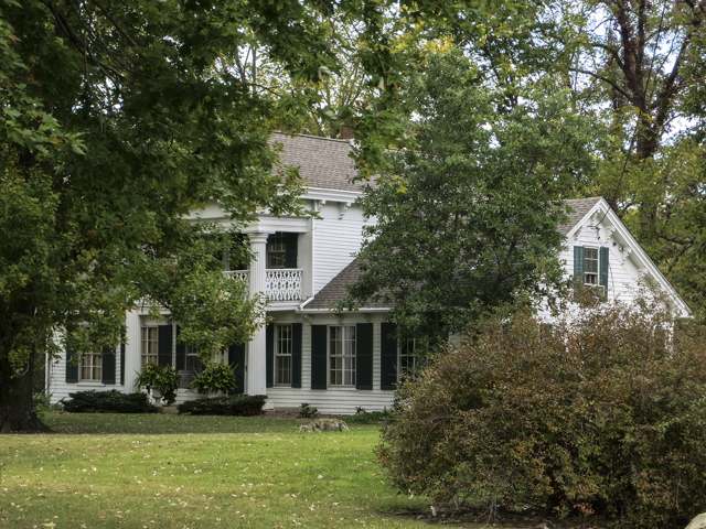
Photo: Tim Erskine, via Wikimedia Commons, CC BY-SA 3.0 · Wikimedia Commons
Local history sources: archive.org · en.wikipedia.org · en.wikipedia.org · en.wikipedia.org · commons.wikimedia.org
Water
Olentangy River intake at Del-Co's plant on Olentangy River Rd, Liberty Twp, south of the city of Delaware The water here
- Del-co Water Company, Inc.72% of residentsOlentangy River, O'Shaughnessy and Alum Creek reservoirs, plus Knox County wells
- Ashley Village28% of residentsOlentangy River, O'Shaughnessy and Alum Creek reservoirs, plus Knox County wells
Its ZIP codes
Each ZIP code that touches Marlboro Township, Delaware County, with the share of its residents who live here and the same headline figures as the ZIP page.
| ZIP | Share | Water | Radon | Home value | Schools | Flood |
|---|---|---|---|---|---|---|
| 43356 Waldo Township and Waldo | 8% | Olentangy River intake at Del-Co's plant on Olentangy River Rd, Liberty Twp, south of the city of Delaware | 6.0 pCi/L average radon | Median year built 1973 | River Valley Local · 3.5 stars overall | 13% of residents in the 1% floodplain |
| 43003 Ashley | 5% | Olentangy River intake at Del-Co's plant on Olentangy River Rd, Liberty Twp, south of the city of Delaware | 5.6 pCi/L average radon | Parcel list only | Buckeye Valley Local · 5 stars overall | 5.5% of residents in the 1% floodplain |
| 43066 Radnor Township and Radnor | 4% | Olentangy River intake at Del-Co's plant on Olentangy River Rd, Liberty Twp, south of the city of Delaware | 6.6 pCi/L average radon | Parcel list only | Buckeye Valley Local · 5 stars overall | 5.8% of residents in the 1% floodplain |
The county
Delaware County: 11 ZIP codes, 26 cities, villages and townships, 214,126 people.
Nearby places
Cite this page
Cite this page as:
Cracked Buckeye (Open Shower Co), "Marlboro Township, Delaware County", https://crackedbuckeye.com/place/marlboro-township-delaware-county/, built 2026-09-16, accessed [date].
Machine-readable: /api/place/marlboro-township-delaware-county.json (open JSON, CC BY 4.0 for the compilation; the underlying records keep their own terms) · How to cite · Report a correction · Built 2026-09-16