Local events in Sugar Creek Township, Allen County
Nothing is posted for Sugar Creek Township itself yet; here is what is on within 20 miles. All local events in Sugar Creek Township, Allen County
Know a calendar we should watch? Send the link
Checked October 20; the events page is refreshed daily.
How Sugar Creek Township, Allen County began
Sugar Creek Township was set off in 1831 as a division of what was then Putnam County, becoming Congressional Township 2, Range 6; in 1848 the north tier of sections of the former German Township was added to bring the township to its present boundaries. It took its name from the maple groves along Sugar Creek that pioneer settlers, and before them Shawnee families from the Hog Creek and Wapakoneta country, tapped each spring for syrup and sugar. The township's defining community is Gomer, founded in 1833 by Welsh immigrant families and still an unincorporated hub of Welsh heritage in Ohio; no municipality has ever incorporated within the township, so the city of Lima and its downtown historic district lie outside Sugar Creek Township even though they share a ZIP code.
Incorporated 1831 (organized as a township; never municipally incorporated), by Set off from Putnam County by the Ohio legislature.
Where the name comes from
The township was named for Sugar Creek, itself named for the number and productiveness of the sugar maple groves found along it in pioneer days. Shawnee people from Charloe and the Wapakoneta/Hog Creek area made spring encampments in the district to gather their year's supply of maple sugar before white settlement.
Before the town
No treaty line, village site, mound, or earthwork specific to Sugar Creek Township is recorded in the sources checked. The one site-specific record is seasonal: the 1880s county history states that Shawnee families from Charloe and from the Shawnee settlements to the south made spring encampments in this district to tap the sugar maple groves along Sugar Creek and produce their year's supply of maple sugar. The Hog Creek Shawnee reservation, granted by the 1817 Treaty of the Maumee Rapids (Fort Meigs) and held until the Shawnee removal to Kansas in 1832-33, lay along the Ottawa (Hog) River to the southeast and comprised most of present-day Shawnee Township, not Sugar Creek Township; it is noted here as regional context, not as a Sugar Creek Township site. The fuller Native American record of Allen County includes the Wapakoneta and Hog Creek Shawnee reservations, the Treaty of the Maumee Rapids, and removal in 1832-33.
Nations recorded here: Shawnee.
Timeline
- — Sugar Creek Township is set off from Putnam County as Congressional Township 2, Range 6; James Porter, Daniel Gray and William Turner serve as first trustees, Abram Sarber as clerk, Benjamin Clevenger as treasurer, and Obed Martin as justice of the peace.
- — Benjamin Clevenger builds the township's first mill, on Sugar Creek.
- — James Nicholas arrives in September and finds Welsh families already settled, including Sanford and Arnold Bertch, Thomas Dehen, John Enslen, Frederick Ehernman, Thomas Watkins, David Roberts and Adam Bussart; William Ramsey opens the township's first school, a subscription school with 15 to 16 scholars. The same year, three Welshmen — of the Watkins, Roberts and Nicholas families — found Gomer.
- — The Bucyrus and Fort Wayne road is built through the township, following the earlier Lima-to-Defiance route.
- — Welsh settlers erect a log Congregational church, the township's first house of worship built by the Welsh community.
- — In a county-wide reorganization, the north tier of sections of the former German Township (Township 3 south, Range 6 east) is added to the south half of Sugar Creek Township, fixing its present boundaries.
- — Samuel Ramsay and James Nicholas lay out the village of Gomer, in sections 20, 21, 28 and 29 of the township.
- — The Welsh Congregational congregation at Gomer replaces its 1838 log church with a brick building costing about $17,000; the building still stands.
- — Sugar Creek Township High School is built on the north side of the Lincoln Highway at the eastern end of Gomer.
Stories
A Welsh village that never incorporated
In 1833 three Welsh immigrant families — Watkins, Roberts and Nicholas — settled the north end of Sugar Creek Township and named their new home Gomer, for a biblical figure and a district of Wales. Word reached family and neighbors back home, and by the time Samuel Ramsay and James Nicholas formally platted the village in 1850, Gomer had become one of Ohio's leading Welsh settlements, ranked alongside Paddy's Run, Radnor and the Welsh Hills near Granville. The Welsh congregation built a log church in 1838 and replaced it in 1873 with a brick building that cost about $17,000, a large sum for a rural township at the time. Gomer never incorporated as a village or city; it remains, to this day, an unincorporated community that is also the seat of the township government, whose hall sits on Lincoln Highway a few hundred feet from the church and the 1931 high school building. The persistence of Welsh surnames on mailboxes and gravestones around Gomer is the clearest surviving mark of that 1833 migration.
Sugar camp before the survey
Before settlers arrived, Shawnee families were already working Sugar Creek Township's maple groves each spring. The 1880s county history records that people from Charloe and the Shawnee towns to the south made seasonal encampments here to tap the sugar maples and boil down their year's supply of syrup and sugar — the same resource that gave the creek, and later the township, its name. The settlers who came in the early 1830s were taking up land that already had a working season attached to it, even if no permanent Shawnee village stood on this exact ground in the written record.
Photographs
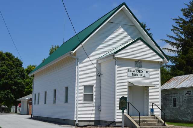
Photo: Nyttend, public domain · Wikimedia Commons

Photo: Nyttend, public domain · Wikimedia Commons
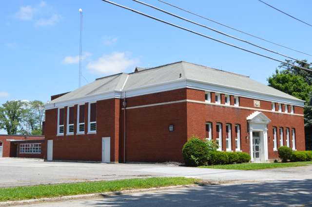
Photo: Nyttend, public domain · Wikimedia Commons
Local history sources: genealogytrails.com · en.wikipedia.org · en.wikipedia.org · ohiohistorycentral.org · commons.wikimedia.org · commons.wikimedia.org · commons.wikimedia.org
Water
Mostly private wells The water here
- Elida Village54% of residentsAuglaize River and Ottawa River, stored in city upground reservoirs
- Lima City46% of residentsAuglaize River and Ottawa River, stored in city upground reservoirs
Hospitals, fire stations and more
Inside Sugar Creek Township, Allen County's boundary: 5 poor-rated bridges, 1 museum and 10 spill cases. Press a pin or a name for its whole record and its source.
Bridges rated poor (5)
-
Gomer Rd over Pike Run - Gomer RdPoor · built 1951
- Condition
- Poor: a deck, superstructure, substructure or culvert rated 4 or below on the 0 to 9 scale
- What it is
- Bridge
- Built
- 1951
- Length
- 17 ft
- Owner
- County
- Vehicles a day
- 508
- Coordinates
- 40.84652, -84.18606
National Bridge Inventory (source) ↗ Street map and directions ↗
-
Lincoln Hwy. over Pike Run Lincoln HwyPoor · built 1955
- Condition
- Poor: a deck, superstructure, substructure or culvert rated 4 or below on the 0 to 9 scale
- What it is
- Bridge
- Built
- 1955
- Length
- 22 ft
- Owner
- County
- Vehicles a day
- 671
- Coordinates
- 40.84059, -84.17231
National Bridge Inventory (source) ↗ Street map and directions ↗
-
Lincoln Hwy. over Sugar Creek Lincoln HwyPoor · built 1960
- Condition
- Poor: a deck, superstructure, substructure or culvert rated 4 or below on the 0 to 9 scale
- What it is
- Bridge
- Built
- 1960
- Length
- 26 ft
- Owner
- County
- Vehicles a day
- 537
- Coordinates
- 40.83151, -84.13441
National Bridge Inventory (source) ↗ Street map and directions ↗
-
Sandy Point Rd. over Beaver Run Sandy PointPoor · built 1975
- Condition
- Poor: a deck, superstructure, substructure or culvert rated 4 or below on the 0 to 9 scale
- What it is
- Culvert
- Built
- 1975
- Length
- 8 ft
- Owner
- County
- Vehicles a day
- 327
- Coordinates
- 40.81156, -84.16570
National Bridge Inventory (source) ↗ Street map and directions ↗
-
Wapak Rd. over Honey Run Wapak RdPoor · built 1977
- Condition
- Poor: a deck, superstructure, substructure or culvert rated 4 or below on the 0 to 9 scale
- What it is
- Bridge
- Built
- 1977
- Length
- 21 ft
- Owner
- County
- Vehicles a day
- 337
- Coordinates
- 40.80983, -84.21596
National Bridge Inventory (source) ↗ Street map and directions ↗
Source: FHWA National Bridge Inventory 2025. "Poor" means one major part rated 4 or below on the 0 to 9 scale; it calls for repair, not closing, unless the state posts or closes the bridge.
Museums, historical societies, gardens and zoos (1)
-
Gomer Welsh Community MuseumMuseum · Gomer
- What it is
- Museum
- City
- Gomer
- Coordinates
- 40.84515, -84.18539
Search Wikipedia ↗ IMLS Museum Data Files (source) ↗ Street map and directions ↗
The museum list is IMLS's 2018 file; a museum may have closed or moved since.
Source: IMLS Museum Data Files, 2018.
Spills reported since 2021 (10)
-
Fuel Diesel / Diesel Fuel (Vehicle On Or Off Road)2025-09-29 · Sugar Creek Twp
- Reported
- 2025-09-29
- What spilled
- Fuel Diesel / Diesel Fuel (Vehicle On Or Off Road)
- Largest amount reported
- 50 gallons
- Where
- Sugar Creek Twp, Allen County
- Ohio EPA district office
- NWDO
- Ohio EPA case number
- 2509EPA0001617
Ohio EPA spill reports (source) ↗ Street map and directions ↗
-
Fuel Diesel / Diesel Fuel (Vehicle On Or Off Road)2025-06-19 · Sugar Creek Twp
- Reported
- 2025-06-19
- What spilled
- Fuel Diesel / Diesel Fuel (Vehicle On Or Off Road)
- Largest amount reported
- 30 gallons
- Where
- Sugar Creek Twp, Allen County
- Ohio EPA district office
- NWDO
- Ohio EPA case number
- 2506EPA0001013
Ohio EPA spill reports (source) ↗ Street map and directions ↗
-
Fuel Diesel / Diesel Fuel (Vehicle On Or Off Road)2025-04-19 · Sugar Creek Twp
- Reported
- 2025-04-19
- What spilled
- Fuel Diesel / Diesel Fuel (Vehicle On Or Off Road)
- Where
- Sugar Creek Twp, Allen County
- Ohio EPA district office
- NWDO
- Ohio EPA case number
- 2504EPA0000593
Ohio EPA spill reports (source) ↗ Street map and directions ↗
-
Fuel Diesel / Diesel Fuel (Vehicle On Or Off Road)2023-05-14 · Sugar Creek Twp
- Reported
- 2023-05-14
- What spilled
- Fuel Diesel / Diesel Fuel (Vehicle On Or Off Road)
- Largest amount reported
- 30 gallons
- Where
- Sugar Creek Twp, Allen County
- Ohio EPA district office
- NWDO
- Ohio EPA case number
- 2305EPA0000783
Ohio EPA spill reports (source) ↗ Street map and directions ↗
-
Fuel Diesel / Diesel Fuel (Vehicle On Or Off Road)2023-02-27 · Sugar Creek Twp
- Reported
- 2023-02-27
- What spilled
- Fuel Diesel / Diesel Fuel (Vehicle On Or Off Road)
- Largest amount reported
- 40 gallons
- Where
- Sugar Creek Twp, Allen County
- Ohio EPA district office
- NWDO
- Ohio EPA case number
- 2302EPA0000298
Ohio EPA spill reports (source) ↗ Street map and directions ↗
-
Fuel Diesel / Diesel Fuel (Vehicle On Or Off Road) Reached water2022-07-22 · Sugar Creek Twp
- Reported
- 2022-07-22
- What spilled
- Fuel Diesel / Diesel Fuel (Vehicle On Or Off Road)
- Largest amount reported
- 30 gallons
- Reached a waterway
- 02 - Ottawa River
- Where
- Sugar Creek Twp, Allen County
- Ohio EPA district office
- NWDO
- Ohio EPA case number
- 2207EPA0001113
Ohio EPA spill reports (source) ↗ Street map and directions ↗
-
Oil Motor / Lube Oil / Vehicle Reached water2022-04-18 · Sugar Creek Twp
- Reported
- 2022-04-18
- What spilled
- Oil Motor / Lube Oil / Vehicle
- Reached a waterway
- 99 - Unnamed
- Where
- Sugar Creek Twp, Allen County
- Ohio EPA district office
- NWDO
- Ohio EPA case number
- 2204EPA0000529
Ohio EPA spill reports (source) ↗ Street map and directions ↗
-
Fuel Diesel / Diesel Fuel (Vehicle On Or Off Road)2026-07-21 · Sugar Creek Twp
- Reported
- 2026-07-21
- What spilled
- Fuel Diesel / Diesel Fuel (Vehicle On Or Off Road)
- Largest amount reported
- 10 gallons
- Where
- Sugar Creek Twp, Allen County
- Ohio EPA district office
- NWDO
- Ohio EPA case number
- 2607EPA0001325
Ohio EPA spill reports (source) ↗ Street map and directions ↗
-
Fuel Diesel / Diesel Fuel (Vehicle On Or Off Road)2026-07-17 · Sugar Creek Twp
- Reported
- 2026-07-17
- What spilled
- Fuel Diesel / Diesel Fuel (Vehicle On Or Off Road)
- Largest amount reported
- 50 gallons
- Where
- Sugar Creek Twp, Allen County
- Ohio EPA district office
- NWDO
- Ohio EPA case number
- 2607EPA0001304
Ohio EPA spill reports (source) ↗ Street map and directions ↗
-
Fuel Diesel / Diesel Fuel (Vehicle On Or Off Road)2026-02-06 · Sugar Creek Twp
- Reported
- 2026-02-06
- What spilled
- Fuel Diesel / Diesel Fuel (Vehicle On Or Off Road)
- Largest amount reported
- 50 gallons
- Where
- Sugar Creek Twp, Allen County
- Ohio EPA district office
- NWDO
- Ohio EPA case number
- 2602EPA0000136
Ohio EPA spill reports (source) ↗ Street map and directions ↗
Source: Ohio EPA emergency response spill reports, 2021 to September 2026, one point per case where Ohio EPA placed it. A report is what the caller or responder recorded; amounts are often blank or estimated.
Its ZIP codes
Each ZIP code that touches Sugar Creek Township, Allen County, with the share of its residents who live here and the same headline figures as the ZIP page.
| ZIP | Share | Water | Radon | Home value | Schools | Flood |
|---|---|---|---|---|---|---|
| 45809 Sugar Creek Township and Gomer | 100% | Mostly private wells | Too few radon tests | Appraisal records without year built | Elida Local · 3.5 stars overall | 0.0% of residents in the 1% floodplain |
| 45807 American Township and Lima | 9% | Auglaize River water fills the Bresler and Williams upground reservoirs west of Lima; Ottawa River water fills the Ferguson, Metzger Lake and Lost Creek reservoirs east of Lima; both feed the East Wayne Street treatment plant | 4.7 pCi/L average radon | Appraisal records without year built | Elida Local · 3.5 stars overall | 4.3% of residents in the 1% floodplain |
Local government
Who holds office in Sugar Creek Township, Allen County, how its elections and ballot issues came out, and the state auditor's record.
Elections for office
| Date | Office | Candidates and votes |
|---|---|---|
| 2017-11-07 | Township Trustee | R. Brian Overholt 247, 49.9%; w. Rodney Watkins 248, 50.1% |
| 2015-11-03 | Township Fiscal Officer | Edward J. Barnhart 355, 100.0% |
Winners in bold. Results from the county board of elections' official canvass unless marked.
Auditor of State record
- No fiscal caution, watch or emergency on the Auditor of State's lists.
- Agreed Upon Procedures, 2022 to 2023, released 2024-11-07
The county
Allen County: 13 ZIP codes, 26 cities, villages and townships, 110,066 people.
Nearby places
Quick answers
What county is Sugar Creek Township, Ohio in?
Sugar Creek Township, Allen County is a township in Allen County, Ohio, with 1,231 residents.
When was Sugar Creek Township, Ohio founded?
Sugar Creek Township, Allen County was incorporated 1831 (organized as a township; never municipally incorporated). Founders on record: Set off from Putnam County by the Ohio legislature. Source
How did Sugar Creek Township, Ohio get its name?
The township was named for Sugar Creek, itself named for the number and productiveness of the sugar maple groves found along it in pioneer days. Source
What ZIP code is Sugar Creek Township, Ohio?
Sugar Creek Township, Allen County is served by ZIP codes 45809 and 45807; 45809 holds the largest share of its residents.
Where does Sugar Creek Township, Ohio get its water?
The main water source for Sugar Creek Township, Allen County (Elida Village): Mostly private wells.
Cite this page
Cite this page as:
Cracked Buckeye, "Sugar Creek Township, Allen County", https://crackedbuckeye.com/place/sugar-creek-township-allen-county/, built 2026-10-31, accessed [date].
How to cite · Report a correction · Built 2026-10-31
