Local events in West Salem
28 events in the next 90 days from 1 public calendar. All local events in West Salem
Checked October 20; the events page is refreshed daily.
Videos about West Salem
Short videos we made from the old maps and records. All videos
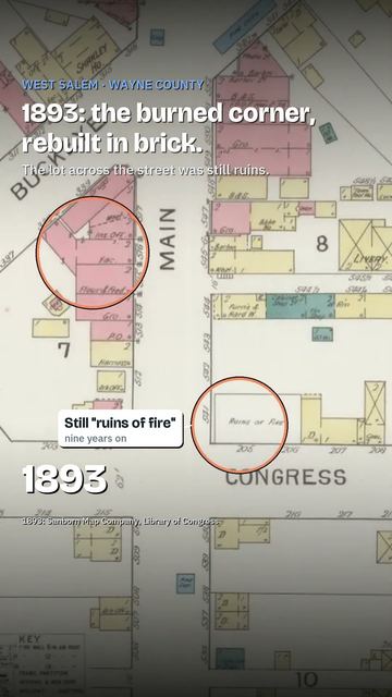
How West Salem began
West Salem was laid out on June 14, 1834, by the brothers Peter and John Rickel on the quarter section Peter had entered in Congress Township, in Wayne County's northwest corner. Joseph Harbaugh built the first house, James Houston kept the first tavern and William Cass opened the first store. A post office opened in 1851 (a 1910 county history says Civil War days), the village was incorporated in 1868 with D. H. Ambrose as mayor, and by 1877 it had a brick school building called the finest in the county outside Wooster. The population peaked at 1,534 in 1990 and was 1,430 in 2020.
Settled 1820-1822 (Peter Rickel entered the land about 1820; his family arrived October 10, 1822), platted June 14, 1834 (plat recorded June 17, 1834, county records vol. 2, p. 443), incorporated 1868, by Peter and John Rickel, surveyed by George Emery.
Where the name comes from
No source checked explains why the Rickels chose the name Salem or added 'West.' The 1878 county history gives only the founders and the date.
Before the town
No mound, village or treaty event specific to West Salem is recorded in the sources checked. Douglass (1878) records, for the Congress Township neighborhood, that Wolf Run, a creek running into Muddy Fork near Myers' mill, was named for Captain Wolf, a Native man who often visited the home of settler Peter Henney, and that a child of Captain Wolf is buried near the creek on the Henney farm; the nation is not named. The 1910 county history says that when the first Totten and Poe families settled Congress Township a camp of 30 or 40 Native people lay near the Harrisville swamp, a few miles north in Medina County. Wayne County as a whole has a recorded Delaware (Lenape), Wyandot and Shawnee history.
- Grave of a child of Captain Wolf, by Wolf Run (burial) — north side of Wolf Run on the north line of the Henney (later Naftzger) farm, Congress Township, early 1800s (undated) (archive.org)
Timeline
- — On October 10 Peter Rickel and his wife Nancy arrive from Bedford County, Pennsylvania, with two children, and build a cabin in the woods; Peter had entered a quarter section two years before, and his brother John had come three years earlier.
- — On June 14 Peter and John Rickel lay out West Salem; the plat is recorded June 17.
- — Joseph Harbaugh builds the first house, on the site of the later McVicker tavern; Jacob Hyatt, its first renter, dies in it three months after moving in, and James Houston keeps the first tavern there.
- — A post office named West Salem is established, according to the postal listing (a 1910 county history says Civil War days); it is still open.
- — Jacob Parrott, listed among West Salem's notable people, a private in the 33rd Ohio Infantry, joins Andrews' Raid in Georgia in April and receives the first Medal of Honor in March 1863; his own biography gives Fairfield County as his birthplace and Kenton as his later home.
- — In December Dr. Justin Georget brings the first printing press to West Salem and issues the monthly West Salem Review.
- — The Agricultural Society of West Salem is organized, with William Buchanan as president.
- — West Salem is incorporated, with D. H. Ambrose as the first mayor.
- — John Wicks of Medina County starts the weekly West Salem Journal, which runs two years.
- — West Salem Lodge No. 442, Odd Fellows, is instituted on June 10.
- — The brick and stone school building is completed at a cost of $35,000, called the finest in Wayne County outside Wooster; it has eleven rooms and a hall seating 700.
- — Two rural free delivery routes are established from West Salem; three more are added in 1904.
- — The village, with about 700 people, installs a gasoline street-lighting system, a large city hall with opera hall (built about 1900) and a semi-volunteer fire department; the Greeley Milling Company runs a roller mill on the edge of town.
- — Village population peaks at 1,534.
- — Population recorded at 1,430.
Stories
Mrs. Peter Rickel remembers landing in the woods
On October 10, 1877, Nancy Rickel, widow of West Salem co-founder Peter Rickel, told the county historian that it was fifty-five years to the day since she and Peter landed in the woods with their two children, coming from Bedford County, Pennsylvania. Peter had come out two years earlier and entered the quarter section on which much of the town was later built. Their first neighbors were the Rev. John Hazzard, a Mr. Ford and Charles Crile; there were no roads, and they had a hard time getting the two-horse wagon through. They built a cabin with a puncheon floor and a stick chimney. Her brother John Rickel, an Albright preacher who came to the county three years ahead of them, joined Peter in laying out the village. Nancy Rickel had seven sons and two daughters, worked in the fields and hauled logs, and said she would gladly live in the woods again, where she could hear the wild birds sing as in the old days.
The first houses and the first press
The first house in West Salem was an old-fashioned frame built by Joseph Harbaugh on a lot that cost him ten or fifteen dollars, where McVicker's tavern later stood. Jacob Hyatt, who rented it first, died in it three months after moving in, and James Houston kept the village's first tavern there. John Reasor put up the second house, where Zehner's store later stood, and William Cass opened the first store, which had no counter but a bench and bought eggs and butter. Thirty-two years after the plat, in December 1866, Dr. Justin Georget brought the first printing press and published a monthly, the West Salem Review, then a medical review. After him came the weekly West Salem Journal in 1868, The True Citizen in 1869, and the Agricultural Commonwealth, begun by F. G. McCauley on January 1, 1871, which was renamed Buckeye Farmer and then West Salem Monitor.
The nation's first Medal of Honor, and a hometown question mark
Jacob Parrott was a private in the 33rd Ohio Infantry when he volunteered in April 1862 for a raid deep into Confederate Georgia: with 21 others he seized the locomotive General and tried to cut the South's rail supply lines in what became known as the Great Locomotive Chase, or Andrews' Raid. Captured and beaten 110 times by captors who tried to make him talk, Parrott survived imprisonment and was exchanged; on March 25, 1863, Secretary of War Edwin Stanton presented him with the first Medal of Honor awarded by the United States. West Salem's Wikipedia article lists him among its notable people, but his own biography gives his birthplace as Fairfield County, Ohio, returned to Kenton, Ohio, after the war, and died there in 1908; it does not mention West Salem or Wayne County.
Local history sources: archive.org · archive.org · en.wikipedia.org · postalhistory.com · en.wikipedia.org
Water
Mostly private wells The water here
- Rural Lorain Co. Water A58% of residentsMostly Lake Erie (bought from Avon Lake); some New London Reservoir and Ashland wells
- West Salem Village42% of residentsGroundwater wells (4 wells)
Hospitals, fire stations and more
Inside West Salem's boundary: 1 fire or EMS station, 1 library, 1 museum, 1 police station, 1 Toxics Release Inventory facility and 2 spill cases. Press a pin or a name for its whole record and its source.
Fire and EMS stations (1)
-
Town and Country Fire DistrictWest Salem
- Address
- 60 North Lincoln Street, West Salem, OH 44287
- Coordinates
- 40.97641, -82.10734
USGS National Map structures (source) ↗ Street map and directions ↗
Source: USGS National Map structures (most Ohio records last updated 2019 to 2022), checked against the Columbus and Cleveland station lists. The department that answers a call is set by jurisdiction and mutual aid, not by distance.
Public libraries (1)
-
West Salem BranchBranch · West Salem
- Address
- 99 East Buckeye St, West Salem, OH 44287
- What it is
- Branch
- Library system
- Wayne County Public Library
- Open
- 1,404 hours a year, 52 weeks
- Building
- 1,872 sq ft
- System's visits, FY2024
- 367,900
- System's loans, FY2024
- 1,989,812
- People the system serves
- 105,271
- Phone
- (330) 804-4712
IMLS Public Libraries Survey (source) ↗ Street map and directions ↗
Source: IMLS Public Libraries Survey FY2024 (outlets and their systems). Any Ohio resident can get a free card at any Ohio public library.
Museums, historical societies, gardens and zoos (1)
-
West Salem Historical SocietyHistorical society · West Salem
- What it is
- Historical society
- City
- West Salem
- Coordinates
- 40.97342, -82.10851
Search Wikipedia ↗ IMLS Museum Data Files (source) ↗ Street map and directions ↗
The museum list is IMLS's 2018 file; a museum may have closed or moved since.
Source: IMLS Museum Data Files, 2018.
Police stations (1)
-
West Salem Village Police DepartmentWest Salem
- Address
- 99 East Buckeye Street, West Salem, OH 44287
- Coordinates
- 40.97482, -82.10706
USGS National Map structures (source) ↗ Street map and directions ↗
Source: USGS National Map structures, police stations, corrected and completed by hand (September 2026). The department that answers a call is set by jurisdiction, not by distance.
Facilities reporting toxic releases (1)
-
Premium Building Prods CoToxics Release Inventory · West Salem
- Address
- 13985 Congress Rd., West Salem, OH 44287
- County
- Wayne County
- Status
- Reports to the Toxics Release Inventory (active)
- EPA program ID
- 44287PRMMB13985
- EPA registry ID
- 110000389204
EPA facility record ↗ EPA Facility Registry Service (source) ↗ Street map and directions ↗
Source: EPA Facility Registry Service, Toxics Release Inventory reporters. Reporting a release is required of large users of listed chemicals; it is not by itself a violation.
Spills reported since 2021 (2)
-
Propylene Glycol (C3H8O2)2025-04-14 · West Salem
- Reported
- 2025-04-14
- What spilled
- Propylene Glycol (C3H8O2)
- Where
- West Salem, Wayne County
- Ohio EPA district office
- NEDO
- Ohio EPA case number
- 2504EPA0000564
Ohio EPA spill reports (source) ↗ Street map and directions ↗
-
Fuel Diesel / Diesel Fuel (Vehicle On Or Off Road)2022-01-27 · West Salem
- Reported
- 2022-01-27
- What spilled
- Fuel Diesel / Diesel Fuel (Vehicle On Or Off Road)
- Largest amount reported
- 80 gallons
- Where
- West Salem, Wayne County
- Ohio EPA district office
- NEDO
- Ohio EPA case number
- 2201EPA0000084
Ohio EPA spill reports (source) ↗ Street map and directions ↗
Source: Ohio EPA emergency response spill reports, 2021 to September 2026, one point per case where Ohio EPA placed it. A report is what the caller or responder recorded; amounts are often blank or estimated.
Its ZIP codes
Each ZIP code that touches West Salem, with the share of its residents who live here and the same headline figures as the ZIP page.
| ZIP | Share | Water | Radon | Home value | Schools | Flood |
|---|---|---|---|---|---|---|
| 44287 Jackson Township and West Salem | 19% | Mostly private wells | 4.1 pCi/L average radon | Median year built 1986 | Northwestern Local · 4 stars overall | 1.0% of residents in the 1% floodplain |
Local government
Who holds office in West Salem, how its elections and ballot issues came out, and the state auditor's record.
Auditor of State record
- No fiscal caution, watch or emergency on the Auditor of State's lists.
- Agreed Upon Procedures, 2023 to 2024, released 2025-09-04
The county
Wayne County: 15 ZIP codes, 33 cities, villages and townships, 124,210 people.
Nearby places
Rain and snow
How much has actually fallen on West Salem, day by day, from 1893 to now. Daily totals, not averages.
- rain, last 30 days
- 2.04 in
- 2026-09-30 to 2026-10-29
- rain so far in 2026
- 34.5 in
- about normal for the date
- snow so far in 2026
- 30.0 in
- a normal year brings 37.0 in
- a normal year
- 40.1 in
- average of 30 years, 1991-2020
| Month | Rain (in) | Snow (in) | Days counted |
|---|---|---|---|
| October 2026 | 2.04 | — | 29 |
| September 2026 | 4.06 | — | 30 |
| August 2026 | 2.99 | — | 31 |
| July 2026 | 3.75 | — | 31 |
| June 2026 | 3.81 | — | 30 |
| May 2026 | 4.77 | — | 31 |
| April 2026 | 6.97 | 0.1 | 30 |
| March 2026 | 3.95 | 0.8 | 31 |
| February 2026 | 0.74 | 4.5 | 28 |
| January 2026 | 1.39 | 24.6 | 31 |
| December 2025 | 1.90 | 8.4 | 31 |
| November 2025 | 1.59 | 1.4 | 30 |
| Wettest year | 2011 — 57.2 in |
|---|---|
| Driest year | 1963 — 22.8 in |
| Snowiest year | 1910 — 74.3 in |
| Wettest day on record | 5 July 1969 — 6.60 in |
| Heaviest snowfall in a day | 9 November 1913 — 15.47 in |
| Deepest snow on the ground | 9 November 1913 — 18.49 in |
Estimated, not measured. No rain gauge has ever stood inside West Salem, so every figure here is worked out from the gauges around it - the nearest ones weighted most. Treat them as close estimates rather than readings.
48,792 days of records, 1893-01-01 to 2026-10-29. Source: NOAA NCEI GHCN-Daily, 3,240 gauges in and around Ohio. A day is "gauged" when a gauge standing inside the boundary reported it, and the value is the mean of those gauges. Otherwise it is interpolated by inverse distance from every gauge reporting within 50 miles. Nothing is carried forward, back-filled or smoothed. Against NOAA nClimDiv county monthly precipitation over 136,848 complete county-months (checked 2026-10-31): correlation 0.9515, median absolute difference 0.217 in a month. Built 2026-10-31 from the Cracked Buckeye precipitation archive. Snow is the softer number — snowfall is measured by hand with a ruler, no agency publishes a gridded county snowfall series, and blowing snow defeats every observer.
Environmental permits and filings
What Ohio EPA has on file for West Salem: permits, inspections, violations, cleanups and the state loans behind sewer and water work. Every line links to the agency's own document.
- facilities and sites on file
- 7
- those placed on the map inside West Salem
| Program | Facilities and sites |
|---|---|
| Air pollution | 2 |
| Hazardous waste | 2 |
| Public drinking water | 1 |
| State sewer loans | 1 |
| State water loans | 1 |
| Date | Facility or site | What |
|---|---|---|
| WEST SALEM VILLAGE PWS | Public drinking water notice of violation | |
| WEST SALEM VILLAGE PWS | Public drinking water notice of violation | |
| WEST SALEM VILLAGE PWS | Public drinking water report | |
| WEST SALEM VILLAGE PWS | Public drinking water plan | |
| WEST SALEM VILLAGE PWS | Public drinking water plan | |
| PREMIUM BUILDING PRODUCTS CO | Air pollution report | |
| WEST SALEM VILLAGE PWS | Public drinking water plan | |
| WEST SALEM VILLAGE PWS | Public drinking water inspection | |
| WEST SALEM VILLAGE PWS | Public drinking water letter | |
| WEST SALEM VILLAGE PWS | Public drinking water notice of violation | |
| WEST SALEM VILLAGE PWS | Public drinking water notice of violation | |
| WEST SALEM VILLAGE PWS | Public drinking water notice of violation | |
| WEST SALEM VILLAGE PWS | Public drinking water inspection | |
| WEST SALEM VILLAGE PWS | Public drinking water withdrawn | |
| WEST SALEM VILLAGE PWS | Public drinking water notice of violation | |
| WEST SALEM VILLAGE PWS | Public drinking water notice of violation | |
| WEST SALEM VILLAGE PWS | Public drinking water notice of violation | |
| WEST SALEM VILLAGE PWS | Public drinking water report | |
| WEST SALEM VILLAGE PWS | Public drinking water inspection | |
| WEST SALEM VILLAGE PWS | Public drinking water compliance letter | |
| WEST SALEM VILLAGE PWS | Public drinking water notice of violation | |
| WEST SALEM VILLAGE PWS | Public drinking water compliance letter | |
| WEST SALEM VILLAGE PWS | Public drinking water violation resolved | |
| WEST SALEM VILLAGE PWS | Public drinking water plan | |
| WEST SALEM VILLAGE PWS | Public drinking water report |
Source: Ohio EPA eDocument portal (edocpub.epa.ohio.gov), indexed 2026-10-14. Facilities are placed on the map from Ohio EPA's own map layers, EPA's Facility Registry, coordinates written in the filings, or a geocoded street address. A permit filed under a private person's name (most are household septic systems) is counted but never named, placed or linked; licenses for individual workers and open-burning notices are left out entirely.
Quick answers
What county is West Salem, Ohio in?
West Salem is a village in Wayne County, Ohio, with 1,441 residents.
When was West Salem, Ohio founded?
West Salem was settled 1820-1822 (Peter Rickel entered the land about 1820; his family arrived October 10, 1822); laid out June 14, 1834 (plat recorded June 17, 1834, county records vol. 2, p. 443); incorporated 1868. Founders on record: Peter and John Rickel, surveyed by George Emery. Source
What ZIP code is West Salem, Ohio?
Most of West Salem is in ZIP code 44287.
Where does West Salem, Ohio get its water?
The main water source for West Salem (Rural Lorain Co. Water A): Mostly private wells.
Cite this page
Cite this page as:
Cracked Buckeye, "West Salem, Wayne County", https://crackedbuckeye.com/place/west-salem/, built 2026-10-31, accessed [date].
How to cite · Report a correction · Built 2026-10-31
