Local events in Perry Township, Allen County
Nothing is posted for Perry Township itself yet; here is what is on within 20 miles. All local events in Perry Township, Allen County
Know a calendar we should watch? Send the link
Checked October 20; the events page is refreshed daily.
How Perry Township, Allen County began
Perry Township was still Shawnee country along Hog Creek when John Ridenour and his family arrived from Perry County in 1830 to become its first white settlers; Chief Quilna and other Shawnee leaders were still frequent visitors before the band's 1832 removal. The county board formally established the township in December 1833, and it organized the following April. Two small platted villages, Warsaw and South Warsaw, grew up on the Auglaize River but never amounted to much, and today the township is mostly farmland with part of the city of Lima reaching into its northwest corner.
Settled 1830 (John Ridenour and family, from Perry County, Ohio), incorporated established by the county board December 1833; organized April 7, 1834 at the house of Joseph Crossley, by first trustees Hugh Skilling Sr., John Ridenour and Joseph Crossley; justice of the peace Moses McDonald; clerk James Chenoweth.
Where the name comes from
No source consulted explains why the township took the name Perry; it is one of twenty-six townships named Perry in Ohio, most likely honoring Commodore Oliver Hazard Perry of the War of 1812, a common naming choice statewide, but no township-specific record of the naming was found.
Before the town
When John Ridenour's family settled here in 1830, the 1885 county history describes the area as 'almost a wilderness, occupied largely by the Shawnees along Hog Creek,' with Chief Quilna and other Shawnee leaders frequent visitors to the new settlers before the Hog Creek band's 1832 removal to Kansas. The township lies along the Auglaize River rather than directly on the Hog Creek reservation itself (which centered on Shawnee Township, Perry's western neighbor), but Shawnee people were still present and visiting as late as 1830-32. No mound, earthwork, or named village site specific to Perry Township was found in the sources checked. A 'Fort Amanda Site' NRHP listing tied to ZIP 45806 does not belong here: Fort Amanda is a War of 1812 site in Logan Township, Auglaize County, roughly nine miles from Lima, confirmed by its own National Register listing and by Wikipedia's Fort Amanda article -- it is not in Allen County.
Nations recorded here: Shawnee.
Timeline
- — John Ridenour and family remove from Perry County and settle a mile south of the future Lima, the township's first settlers, while Shawnee people are still present along Hog Creek.
- — The Shawnee living in the area depart as part of the wider Hog Creek band removal.
- — December: The Allen County board formally establishes Perry Township.
- — April 7: The township organizes at the house of Joseph Crossley, electing Hugh Skilling Sr., John Ridenour and Joseph Crossley as its first trustees.
- — John Ridenour and Leonard Skilling open the township's first school, on Section 8 (the Budd farm).
- — A second schoolhouse opens on Section 25, with John Terry as teacher.
- — Perry Chapel (now Anchored Hope Baptist Church), a Carpenter Gothic wooden church, is built in the township.
Stories
Arriving while the Shawnee were still there
When John Ridenour brought his family from Perry County in the spring of 1830 and settled a mile south of the spot that would become Lima, the 1885 county history remembered the county as 'almost a wilderness, occupied largely by the Shawnees along Hog Creek.' Ridenour's family, including his sons Jacob and David, were not moving into empty land: Chief Quilna and other Shawnee leaders were frequent visitors to the new cabins in those first years, part of the Hog Creek band that would not leave the area for good until 1832. By 1840, the county history notes, the township 'presented a very primitive appearance' -- Ridenour and the handful of families who followed him were still clearing a frontier that had only just stopped being Shawnee country.
Two Warsaws on the Auglaize
Perry Township's early promoters platted not one but two villages on the Auglaize River: Warsaw, in Section 27, and a rival plat called South Warsaw in Section 35, laid out with nine blocks. A third plat, Amherst, spread across Sections 27, 28, 33 and 34. None of the three ever grew into a lasting town; the 1885 county history records them mainly as failed paper villages, and the township's real center of gravity stayed rural, oriented toward its farms, schools and churches rather than any incorporated place. The nearest mill, township residents had to travel two and a half miles into neighboring Auglaize Township to reach.
Photographs
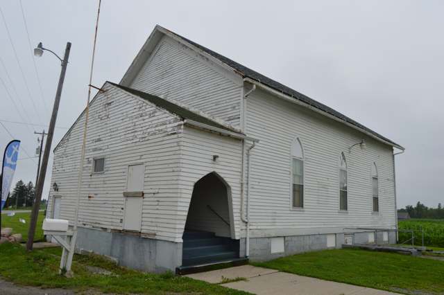
Photo: Nyttend, public domain · Wikimedia Commons
Local history sources: ohiogenealogyexpress.com · en.wikipedia.org · en.wikipedia.org · en.wikipedia.org · commons.wikimedia.org
Water
Auglaize River water fills the Bresler and Williams upground reservoirs west of Lima; Ottawa River water fills the Ferguson, Metzger Lake and Lost Creek reservoirs east of Lima; both feed the East Wayne Street treatment plant The water here
- Lima City88% of residentsAuglaize River and Ottawa River, stored in city upground reservoirs
- Cridersville Village11% of residentsGroundwater wells (4 wells)
- Brightstar Lima MHP1% of residentsGroundwater wells (2 wells)
Hospitals, fire stations and more
Inside Perry Township, Allen County's boundary: 1 hospital, 1 nursing home, 1 fire or EMS station, 2 public schools, 3 poor-rated bridges, 1 police station, 2 public charging sites, 1 Superfund site, 1 Toxics Release Inventory facility and 12 spill cases. Press a pin or a name for its whole record and its source.
Hospitals (1)
-
Institute for Orthopaedic SurgerySpecialty hospital · Lima
- What it is
- Specialty hospital
- Address
- 801 Medical Drive, Suite B, Lima, OH 45804
- County
- Allen County
- Beds
- 12
- Helipad
- Yes
- Ownership
- Proprietary
- Medicare overall rating
- not rated
- Emergency department (Medicare)
- No
- Phone
- (419) 224-7586
- Medicare ID
- 360263
Medicare Care Compare ↗ Where HIFLD got this record ↗ HIFLD hospitals (source) ↗ Street map and directions ↗
Source: HIFLD hospitals inventory via FEMA (closed hospitals it still lists left out, hospitals opened since added), with Medicare Care Compare ratings matched by name and address.
Nursing homes (1)
-
Lost Creek Rehabilitation and Nursing Center1 of 5 stars · Lima
- Address
- 804 South Mumaugh Road, Lima, OH 45804
- Certified beds
- 54
- Residents on an average day
- 43
- Medicare overall rating
- 1 of 5 stars
- Health inspections
- 2 of 5 stars
- Staffing
- 1 of 5 stars
- Quality measures
- 4 of 5 stars
- Penalties since 2023
- 2 fines totalling $55,088 (latest 2025-06-09)
- Ownership
- For profit - Limited Liability company
- Takes
- Medicare and Medicaid
- Phone
- (419) 225-9040
- Medicare ID
- 365600
Medicare Care Compare ↗ CMS nursing home data (source) ↗ Street map and directions ↗
Source: CMS Care Compare nursing home provider and penalties files; Medicare star ratings run 1 to 5.
Fire and EMS stations (1)
-
Perry Township Fire DepartmentLima
- Address
- 2408 East Breese Road, Lima, OH 45806
- Coordinates
- 40.68732, -84.05975
USGS National Map structures (source) ↗ Street map and directions ↗
Source: USGS National Map structures (most Ohio records last updated 2019 to 2022), checked against the Columbus and Cleveland station lists. The department that answers a call is set by jurisdiction and mutual aid, not by distance.
Public schools (2)
-
Perry Elementary School3.5 of 5 stars · Lima
- Address
- 2770 E Breese Rd, Lima, OH 45806
- School district
- Perry Local School District
- Kind (NCES)
- Regular School
- Students, 2023-24
- 404
- Teachers (full-time equivalent)
- 26
- Report card, 2025-26
- 3.5 of 5 stars
- Performance index
- 73.9%
- Ohio building IRN
- 029686
- NCES school ID
- 390457802341
NCES school record ↗ Ohio School Report Card ↗ Street map and directions ↗
-
Perry High School3.5 of 5 stars · Lima
- Address
- 2770 E Breese Rd, Lima, OH 45806
- School district
- Perry Local School District
- Kind (NCES)
- Regular School
- Students, 2023-24
- 323
- Teachers (full-time equivalent)
- 18
- Report card, 2025-26
- 3.5 of 5 stars
- Performance index
- 71.9%
- Four-year graduation rate
- 98.3%
- Ohio building IRN
- 029694
- NCES school ID
- 390457802342
NCES school record ↗ Ohio School Report Card ↗ Street map and directions ↗
Source: NCES EDGE public school locations 2024-25 and Common Core of Data 2023-24 (type, students, teachers); Ohio School Report Cards 2025-26 (Department of Education and Workforce), matched by name within the district.
Bridges rated poor (3)
-
Ream Rd. over Auglaize River Ream RdPoor · built 1974
- Condition
- Poor: a deck, superstructure, substructure or culvert rated 4 or below on the 0 to 9 scale
- What it is
- Bridge
- Built
- 1974
- Length
- 32 ft
- Owner
- County
- Vehicles a day
- 323
- Coordinates
- 40.66378, -84.04665
National Bridge Inventory (source) ↗ Street map and directions ↗
-
Schooler Rd. over Auglaize River SchoolerPoor · built 1985
- Condition
- Poor: a deck, superstructure, substructure or culvert rated 4 or below on the 0 to 9 scale
- What it is
- Bridge
- Built
- 1985
- Length
- 26 ft
- Owner
- County
- Vehicles a day
- 600
- Coordinates
- 40.66222, -84.03222
National Bridge Inventory (source) ↗ Street map and directions ↗
-
Wonnell Rd. over Auglaize River WonnellPoor · built 1985
- Condition
- Poor: a deck, superstructure, substructure or culvert rated 4 or below on the 0 to 9 scale
- What it is
- Bridge
- Built
- 1985
- Length
- 24 ft
- Owner
- County
- Vehicles a day
- 109
- Coordinates
- 40.66594, -84.03041
National Bridge Inventory (source) ↗ Street map and directions ↗
Source: FHWA National Bridge Inventory 2025. "Poor" means one major part rated 4 or below on the 0 to 9 scale; it calls for repair, not closing, unless the state posts or closes the bridge.
Police stations (1)
-
Perry Township Police DepartmentLima
- Address
- 2501 East Breese Road, Lima, OH 45806
- Coordinates
- 40.68794, -84.05920
USGS National Map structures (source) ↗ Street map and directions ↗
Source: USGS National Map structures, police stations, corrected and completed by hand (September 2026). The department that answers a call is set by jurisdiction, not by distance.
Public EV charging (2)
-
Hampton Inn - Tesla Supercharger DC fast8 DC fast · Lima
- Address
- 1933 Roschman Ave., Lima, OH 45804
- Ports
- 8 DC fast
- Plugs
- Tesla (NACS)
- Network
- Tesla
- Hours
- 24 hours daily. Please check Tesla's online station map to see if an adapter is required at this location.
- Phone
- 877-798-3752
Station Locator (NREL) ↗ Alternative Fuels Data Center (source) ↗ Street map and directions ↗
-
Holiday Inn Express & Suites Lima - Tesla Destination4 Level 2 · Lima
- Address
- 1925 Motel Ave, Lima, OH 45804
- Ports
- 4 Level 2
- Plugs
- J1772, Tesla (NACS)
- Network
- Tesla Destination
- Phone
- 877-798-3752
Station Locator (NREL) ↗ Alternative Fuels Data Center (source) ↗ Street map and directions ↗
Source: NREL Alternative Fuels Data Center station list (May 2026), public and open stations, the posts at one address counted as one site.
Superfund sites (1)
-
Lima Acrylic ErSuperfund program · Lima
- Address
- 1-75, Lima, OH 45804
- County
- Allen County
- Status
- Superfund program site, not on the National Priorities List
- EPA program ID
- OHN000505850
- EPA registry ID
- 110067036308
EPA facility record ↗ EPA Facility Registry Service (source) ↗ Street map and directions ↗
Source: EPA Facility Registry Service, Superfund (SEMS) and National Priorities List sites. Many program sites were assessed and needed no cleanup.
Facilities reporting toxic releases (1)
-
Pepsi-Cola General Bottlers of Lima IncToxics Release Inventory · Lima
- Address
- 1750 Greely Chapel Rd., Lima, OH 45804
- County
- Allen County
- Status
- Reports to the Toxics Release Inventory (active)
- EPA program ID
- 45804PPSCL1750G
- EPA registry ID
- 110000395457
EPA facility record ↗ EPA Facility Registry Service (source) ↗ Street map and directions ↗
Source: EPA Facility Registry Service, Toxics Release Inventory reporters. Reporting a release is required of large users of listed chemicals; it is not by itself a violation.
Spills reported since 2021 (12)
-
Material White2025-10-14 · Perry Twp
- Reported
- 2025-10-14
- What spilled
- Material White
- Where
- Perry Twp, Allen County
- Ohio EPA district office
- NWDO
- Ohio EPA case number
- 2510EPA0001702
Ohio EPA spill reports (source) ↗ Street map and directions ↗
-
Oil Transformer Non Pcb2024-02-11 · Perry Twp
- Reported
- 2024-02-11
- What spilled
- Oil Transformer Non Pcb
- Where
- Perry Twp, Allen County
- Ohio EPA district office
- NWDO
- Ohio EPA case number
- 2402EPA0000227
Ohio EPA spill reports (source) ↗ Street map and directions ↗
-
Bentonite / Drilling Mud2023-09-13 · Perry Twp
- Reported
- 2023-09-13
- What spilled
- Bentonite / Drilling Mud
- Largest amount reported
- 100 gallons
- Where
- Perry Twp, Allen County
- Ohio EPA district office
- NWDO
- Ohio EPA case number
- 2309EPA0001602
Ohio EPA spill reports (source) ↗ Street map and directions ↗
-
Ammonia (Nh3)2023-06-22 · Perry Twp
- Reported
- 2023-06-22
- What spilled
- Ammonia (Nh3)
- Where
- Perry Twp, Allen County
- Ohio EPA district office
- NWDO
- Ohio EPA case number
- 2306EPA0001031
Ohio EPA spill reports (source) ↗ Street map and directions ↗
-
Oil Motor / Lube Oil / Vehicle2023-05-20 · Perry Twp
- Reported
- 2023-05-20
- What spilled
- Oil Motor / Lube Oil / Vehicle
- Largest amount reported
- 25 gallons
- Where
- Perry Twp, Allen County
- Ohio EPA district office
- NWDO
- Ohio EPA case number
- 2305EPA0000827
Ohio EPA spill reports (source) ↗ Street map and directions ↗
-
Milk2022-09-24 · Perry Twp
- Reported
- 2022-09-24
- What spilled
- Milk; Fuel Diesel / Diesel Fuel (Vehicle On Or Off Road)
- Where
- Perry Twp, Allen County
- Ohio EPA district office
- NWDO
- Ohio EPA case number
- 2209EPA0001467
Ohio EPA spill reports (source) ↗ Street map and directions ↗
-
Fuel Diesel / Diesel Fuel (Vehicle On Or Off Road)2022-03-15 · Perry Twp
- Reported
- 2022-03-15
- What spilled
- Fuel Diesel / Diesel Fuel (Vehicle On Or Off Road)
- Largest amount reported
- 125 gallons
- Where
- Perry Twp, Allen County
- Ohio EPA district office
- NWDO
- Ohio EPA case number
- 2203EPA0000339
Ohio EPA spill reports (source) ↗ Street map and directions ↗
-
Fuel Diesel / Diesel Fuel (Vehicle On Or Off Road)2026-08-27 · Perry Twp
- Reported
- 2026-08-27
- What spilled
- Fuel Diesel / Diesel Fuel (Vehicle On Or Off Road)
- Largest amount reported
- 50 gallons
- Where
- Perry Twp, Allen County
- Ohio EPA district office
- NWDO
- Ohio EPA case number
- 2608EPA0001607
Ohio EPA spill reports (source) ↗ Street map and directions ↗
-
Fuel Diesel / Diesel Fuel (Vehicle On Or Off Road)2026-06-10 · Perry Twp
- Reported
- 2026-06-10
- What spilled
- Fuel Diesel / Diesel Fuel (Vehicle On Or Off Road)
- Largest amount reported
- 40 gallons
- Where
- Perry Twp, Allen County
- Ohio EPA district office
- NWDO
- Ohio EPA case number
- 2606EPA0001019
Ohio EPA spill reports (source) ↗ Street map and directions ↗
-
Sulfur (S)2026-06-08 · Shawnee Twp
- Reported
- 2026-06-08
- What spilled
- Sulfur (S)
- Where
- Shawnee Twp, Allen County
- Ohio EPA district office
- NWDO
- Ohio EPA case number
- 2606EPA0001008
Ohio EPA spill reports (source) ↗ Street map and directions ↗
-
Fuel Diesel / Diesel Fuel (Vehicle On Or Off Road) Reached water2026-03-12 · Perry Twp
- Reported
- 2026-03-12
- What spilled
- Fuel Diesel / Diesel Fuel (Vehicle On Or Off Road)
- Largest amount reported
- 150 gallons
- Reached a waterway
- 02 - Lost Creek
- Where
- Perry Twp, Allen County
- Ohio EPA district office
- NWDO
- Ohio EPA case number
- 2603EPA0000361
Ohio EPA spill reports (source) ↗ Street map and directions ↗
-
Fuel Diesel / Diesel Fuel (Vehicle On Or Off Road)2026-02-23 · Perry Twp
- Reported
- 2026-02-23
- What spilled
- Fuel Diesel / Diesel Fuel (Vehicle On Or Off Road)
- Largest amount reported
- 75 gallons
- Where
- Perry Twp, Allen County
- Ohio EPA district office
- NWDO
- Ohio EPA case number
- 2602EPA0000232
Ohio EPA spill reports (source) ↗ Street map and directions ↗
Source: Ohio EPA emergency response spill reports, 2021 to September 2026, one point per case where Ohio EPA placed it. A report is what the caller or responder recorded; amounts are often blank or estimated.
Its ZIP codes
Each ZIP code that touches Perry Township, Allen County, with the share of its residents who live here and the same headline figures as the ZIP page.
Local government
Who holds office in Perry Township, Allen County, how its elections and ballot issues came out, and the state auditor's record.
Elections for office
| Date | Office | Candidates and votes |
|---|---|---|
| 2017-11-07 | Township Trustee | Norman B. Capps 548, 49.91%; Gregory J. Kessen 550, 50.09% |
| 2015-11-03 | Township Trustee | Kevin W. Cox 791, 100.0% |
| 2015-11-03 | Township Fiscal Officer | Natalie M. Scott 745, 100.0% |
Winners in bold. Results from the county board of elections' official canvass unless marked.
Auditor of State record
- No fiscal caution, watch or emergency on the Auditor of State's lists.
- Agreed Upon Procedures, 2023 to 2024, released 2025-12-30
The county
Allen County: 13 ZIP codes, 26 cities, villages and townships, 110,066 people.
Nearby places
Quick answers
What county is Perry Township, Ohio in?
Perry Township, Allen County is a township in Allen County, Ohio, with 3,382 residents.
When was Perry Township, Ohio founded?
Perry Township, Allen County was settled 1830 (John Ridenour and family, from Perry County, Ohio); incorporated established by the county board December 1833; organized April 7, 1834 at the house of Joseph Crossley. Founders on record: first trustees Hugh Skilling Sr., John Ridenour and Joseph Crossley; justice of the peace Moses McDonald; clerk James Chenoweth. Source
What ZIP code is Perry Township, Ohio?
Perry Township, Allen County is served by ZIP codes 45804 and 45806; 45804 holds the largest share of its residents.
Where does Perry Township, Ohio get its water?
The main water source for Perry Township, Allen County (Lima City): Auglaize River water fills the Bresler and Williams upground reservoirs west of Lima; Ottawa River water fills the Ferguson, Metzger Lake and Lost Creek reservoirs east of Lima; both feed the East Wayne Street treatment plant.
Cite this page
Cite this page as:
Cracked Buckeye, "Perry Township, Allen County", https://crackedbuckeye.com/place/perry-township-allen-county/, built 2026-10-31, accessed [date].
How to cite · Report a correction · Built 2026-10-31
