Local events in Ottawa Hills
27 events in the next 90 days from 1 public calendar. All local events in Ottawa Hills
Checked October 20; the events page is refreshed daily.
Deep dives about Ottawa Hills
Long reads built from maps, newspapers and public records. All deep dives
How Ottawa Hills began
Ottawa Hills is a planned suburb that began in 1915, when Willys-Overland president John North Willys bought roughly 1,200 acres along the Ottawa River and hired the E. H. Close Realty Company, along with nationally known landscape architects and city planners, to lay it out as a designed community rather than a conventional subdivision. About 35 percent of the first hundred-acre section was set aside for parkland, including wooded ground along the river, and restrictive covenants were written in from the start to hold the development to a consistent standard. The oldest section, Plat 1 near Secor Road and Bancroft Street -- where developer E. H. Close himself lived -- still holds many of the earliest homes, and the village, expanded since by annexation, had grown to 4,790 residents by the 2020 census.
Platted 1915, under a master plan for the initial 100-acre unit (Plat 1), by John North Willys (land purchase) and the E. H. Close Realty Company (planning and development).
Where the name comes from
Ottawa Hills takes its name from the Ottawa River, which runs through the community's wooded parkland; the river itself is named for the Odawa (Ottawa) nation, who used the northwestern Ohio river corridors into the nineteenth century.
Before the town
No Native village, camp or treaty event specific to the Ottawa Hills site is recorded in the sources we reviewed. The village takes its name from the Ottawa River, which Waggoner's 1888 history also calls Ten Mile Creek, and which is named for the Odawa (Ottawa) nation. The land north of the Maumee, including this tract, was ceded by the Odawa, Ojibwe (Chippewa), Wyandot and Potawatomi in the 1807 Treaty of Detroit.
Nations recorded here: Odawa (Ottawa).
Timeline
- — The Treaty of Detroit cedes the land north of the Maumee, including the later Ottawa Hills tract, to the United States.
- — Elmer H. Close leaves his partnership with George E. Pomeroy and organizes the E. H. Close Realty Company, the firm that later develops Ottawa Hills.
- — John North Willys, president of the Willys-Overland automobile company, buys about 1,200 acres along the Ottawa River and commissions the E. H. Close Realty Company to plan a designed residential suburb.
- — The Toledo Times reports that landscape architects and city planning engineers have been at work on the tract for over a year.
- — A two-and-a-half-story Colonial Revival house is built at 3404 Brookside Road, among the earliest homes in the new development.
- — Killits's county history lists E. H. Close, who by then has platted and developed 1,500 acres in and near Toledo, as living on Ridgewood Road, Ottawa Hills, with several other Toledo business figures on Ridgewood and Orchard roads.
- — The census records 1,185 residents in Ottawa Hills; the population reaches 3,245 by 1960.
- — The village's population reaches 4,790.
Stories
A car maker's suburb, designed from the start
By 1915 John North Willys had already built Willys-Overland into one of the largest automakers in the country, and he brought the same ambition for order to his side project a few miles from the factory floor: a suburb planned as a single composition rather than grown lot by lot. He bought about 1,200 acres along the Ottawa River, hired the E. H. Close Realty Company, and set landscape architects and city planners to work on the tract for more than a year before the first plat went down -- work thorough enough that the Toledo Times covered it as news in August 1915. Roughly a third of the first hundred acres was reserved as parkland along the wooded riverbank, and restrictive covenants locked in the character of the place before a single house went up. E. H. Close himself chose to live in Plat 1, the section nearest Secor Road, where many of the community's oldest homes -- including a Colonial Revival house at 3404 Brookside Road dating to the very first year -- still stand.
The realty man behind the plan
Elmer Harry Close was born in Bellevue, Ohio, on December 9, 1875, came to Toledo as a boy and studied at the University of Michigan. In 1897 he went into real estate with George E. Pomeroy, and one of their first subdivisions was Harvard Terrace near Walbridge Park. In January 1909 he organized the E. H. Close Realty Company and, by the account in Killits's 1923 history, advertised it on so many fences and barn walls around Toledo that the firm's name became a household word. By 1923 he had platted and developed 1,500 acres in and near Toledo, including Ottawa Hills, Homewood Park and Home Acres, and built the Close Building on Madison Avenue. He lived on Ridgewood Road in Ottawa Hills, the development John North Willys had bought the land for and Close's company had laid out.
Photographs
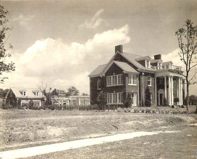
Photo: Toledo Lucas County Public Library, via Digital Public Library of America, no known copyright restrictions · Wikimedia Commons
Local history sources: en.wikipedia.org · commons.wikimedia.org · archive.org · archive.org · archive.org · archive.org
Water
Lake Erie, intake crib roughly 3 miles offshore of the Collins Park plant in Maumee Bay near Oregon, OH The water here
- Toledo City Of100% of residentsLake Erie
Hospitals, fire stations and more
Inside Ottawa Hills's boundary: 2 public schools, 1 poor-rated bridge and 1 spill case. Press a pin or a name for its whole record and its source.
Public schools (2)
-
Ottawa Hills Elementary School5 of 5 stars · Toledo
- Address
- 3602 Indian Rd, Toledo, OH 43606
- School district
- Ottawa Hills Local School District
- Kind (NCES)
- Regular School
- Students, 2023-24
- 554
- Teachers (full-time equivalent)
- 31.22
- Report card, 2025-26
- 5 of 5 stars
- Performance index
- 98.4%
- Ohio building IRN
- 028886
- NCES school ID
- 390482103149
NCES school record ↗ Ohio School Report Card ↗ Street map and directions ↗
-
Ottawa Hills High School5 of 5 stars · Toledo
- Address
- 2532 Evergreen Rd, Toledo, OH 43606
- School district
- Ottawa Hills Local School District
- Kind (NCES)
- Regular School
- Students, 2023-24
- 481
- Teachers (full-time equivalent)
- 32.74
- Report card, 2025-26
- 5 of 5 stars
- Performance index
- 97.6%
- Four-year graduation rate
- 100%
- Ohio building IRN
- 028894
- NCES school ID
- 390482103150
NCES school record ↗ Ohio School Report Card ↗ Street map and directions ↗
Source: NCES EDGE public school locations 2024-25 and Common Core of Data 2023-24 (type, students, teachers); Ohio School Report Cards 2025-26 (Department of Education and Workforce), matched by name within the district.
Bridges rated poor (1)
-
Evergreen Road over Ottawa River 1178Poor · built 1923
- Condition
- Poor: a deck, superstructure, substructure or culvert rated 4 or below on the 0 to 9 scale
- What it is
- Bridge
- Built
- 1923
- Length
- 31 ft
- Owner
- City
- Vehicles a day
- 1,796
- Coordinates
- 41.66411, -83.63724
National Bridge Inventory (source) ↗ Street map and directions ↗
Source: FHWA National Bridge Inventory 2025. "Poor" means one major part rated 4 or below on the 0 to 9 scale; it calls for repair, not closing, unless the state posts or closes the bridge.
Spills reported since 2021 (1)
-
Sheen Rainbow / Hydrocarbon Reached water2021-04-19 · Ottawa Hills
- Reported
- 2021-04-19
- What spilled
- Sheen Rainbow / Hydrocarbon
- Reached a waterway
- 48 - Ottawa River
- Where
- Ottawa Hills, Lucas County
- Ohio EPA district office
- NWDO
- Ohio EPA case number
- 2104EPA0000539
Ohio EPA spill reports (source) ↗ Street map and directions ↗
Source: Ohio EPA emergency response spill reports, 2021 to September 2026, one point per case where Ohio EPA placed it. A report is what the caller or responder recorded; amounts are often blank or estimated.
Its ZIP codes
Each ZIP code that touches Ottawa Hills, with the share of its residents who live here and the same headline figures as the ZIP page.
Local government
Who holds office in Ottawa Hills, how its elections and ballot issues came out, and the state auditor's record.
Auditor of State record
- No fiscal caution, watch or emergency on the Auditor of State's lists.
- OP&F Examination, 2024, released 2026-05-12
- Financial Audit, 2022 to 2023, released 2024-11-07
The county
Lucas County: 26 ZIP codes, 20 cities, villages and townships, 427,372 people.
Nearby places
Rain and snow
How much has actually fallen on Ottawa Hills, day by day, from 1871 to now. Daily totals, not averages.
- rain, last 30 days
- 1.73 in
- 2026-09-30 to 2026-10-29
- rain so far in 2026
- 32.0 in
- 2.6 in above normal for the date
- snow so far in 2026
- 13.4 in
- a normal year brings 32.2 in
- a normal year
- 34.5 in
- average of 30 years, 1991-2020
| Month | Rain (in) | Snow (in) | Days counted |
|---|---|---|---|
| October 2026 | 1.73 | — | 29 |
| September 2026 | 3.53 | — | 30 |
| August 2026 | 4.98 | — | 31 |
| July 2026 | 4.27 | — | 31 |
| June 2026 | 2.99 | — | 30 |
| May 2026 | 2.27 | — | 31 |
| April 2026 | 6.19 | — | 30 |
| March 2026 | 4.56 | 0.0 | 31 |
| February 2026 | 0.57 | 2.1 | 28 |
| January 2026 | 0.94 | 11.3 | 31 |
| December 2025 | 1.51 | 4.2 | 31 |
| November 2025 | 1.74 | 5.3 | 30 |
| Wettest year | 2011 — 51.0 in |
|---|---|
| Driest year | 1963 — 21.1 in |
| Snowiest year | 2014 — 83.4 in |
| Wettest day on record | 4 September 1918 — 5.64 in |
| Heaviest snowfall in a day | 28 February 1900 — 17.16 in |
| Deepest snow on the ground | 1 March 1900 — 19.69 in |
Estimated, not measured. No rain gauge has ever stood inside Ottawa Hills, so every figure here is worked out from the gauges around it - the nearest ones weighted most. Treat them as close estimates rather than readings.
56,915 days of records, 1871-01-01 to 2026-10-29. Source: NOAA NCEI GHCN-Daily, 3,240 gauges in and around Ohio. A day is "gauged" when a gauge standing inside the boundary reported it, and the value is the mean of those gauges. Otherwise it is interpolated by inverse distance from every gauge reporting within 50 miles. Nothing is carried forward, back-filled or smoothed. Against NOAA nClimDiv county monthly precipitation over 136,848 complete county-months (checked 2026-10-31): correlation 0.9515, median absolute difference 0.217 in a month. Built 2026-10-31 from the Cracked Buckeye precipitation archive. Snow is the softer number — snowfall is measured by hand with a ruler, no agency publishes a gridded county snowfall series, and blowing snow defeats every observer.
Quick answers
What county is Ottawa Hills, Ohio in?
Ottawa Hills is a village in Lucas County, Ohio, with 4,790 residents.
When was Ottawa Hills, Ohio founded?
Ottawa Hills was laid out 1915, under a master plan for the initial 100-acre unit (Plat 1). Founders on record: John North Willys (land purchase) and the E. H. Close Realty Company (planning and development). Source
How did Ottawa Hills, Ohio get its name?
Ottawa Hills takes its name from the Ottawa River, which runs through the community's wooded parkland; the river itself is named for the Odawa (Ottawa) nation, who used the northwestern Ohio river corridors into the nineteenth century. Source
What ZIP code is Ottawa Hills, Ohio?
Ottawa Hills is served by ZIP codes 43606 and 43615; 43606 holds the largest share of its residents.
Where does Ottawa Hills, Ohio get its water?
The main water source for Ottawa Hills (Toledo City Of): Lake Erie, intake crib roughly 3 miles offshore of the Collins Park plant in Maumee Bay near Oregon, OH.
Cite this page
Cite this page as:
Cracked Buckeye, "Ottawa Hills, Lucas County", https://crackedbuckeye.com/place/ottawa-hills/, built 2026-10-31, accessed [date].
How to cite · Report a correction · Built 2026-10-31
