Local events in Morristown
Nothing is posted for Morristown itself yet; here is what is on within 10 miles. All local events in Morristown
Know a calendar we should watch? Send the link
Checked October 20; the events page is refreshed daily.
How Morristown began
Morristown was platted in 1802 in Union Township, named for pioneer settler Duncan Morrison, and got its own post office in 1807. Its fortunes rose with the National Road, which became the village's Main Street after 1826 and drew more than forty road-related businesses by the 1850s; when the railroads built through eastern Ohio in that decade bypassed the village, it lost most of its commerce. Its mid-nineteenth-century buildings survive largely intact, and the 42-acre Morristown Historic District, 70 of its 86 buildings contributing, mostly vernacular Flemish-bond brick in Greek Revival and Gothic Revival styles, was listed on the National Register in 1980. The village counted 456 residents in 1850 and 463 in 1980, and has under 250 today.
Platted 1802, by named for Duncan Morrison.
Where the name comes from
Named for Duncan Morrison, a pioneer settler; historically also rendered 'Morris Town.'
Before the town
No Native village, camp, or trail specific to Morristown is recorded here.
Timeline
- — Morristown is platted, named for pioneer settler Duncan Morrison.
- — Duncan Morrison, the founder, kept the first tavern, in a one-story log house; he was also a justice of the peace and militia major.
- — A post office called Morristown begins operating.
- — F. Cumming, touring Belmont County, found Morristown in a hustle after a militia muster for a possible war with Britain, with the country people drinking and fighting and Squire Morrison, trying to keep the peace, getting his clothes torn in a fray.
- — Methodists held the first camp meeting in the township and the second in the county, drawing great crowds for its novelty.
- — The Presbyterian Church of Morristown was organized at Dr. Alexander Gaston's house, building a brick church in 1828 and a larger one in 1848 for $1,400.
- — The National Road becomes Morristown's main thoroughfare, running through the village as Main Street.
- — The Methodist Episcopal society was organized by Rev. John McPherson, building its first church in 1835.
- — The census counts 456 residents, a figure the village does not exceed until 463 in 1980.
- — More than forty National Road-related businesses operate in Morristown at the decade's height, shortly before railroads begin bypassing the village and slowing its growth.
- — The town was incorporated and Peter Bramhill was elected the first mayor, with Joseph R. Mitchell as clerk and Stephen Gregg as treasurer.
- — The Christian Church of Morristown was established, as an offshoot of the Auburn Church, in a building put up under R. B. Atkinson's committee.
- — The census counted 434 residents.
- — The census counted 350 residents; the 1910 count of 280 was the village's lowest.
- — The 42-acre Morristown Historic District, covering 86 buildings along Church, Main, and the Cross Streets, 70 of them contributing, is added to the National Register of Historic Places.
- — The census counted 248 residents.
Stories
Preserved by being passed over
Morristown owed its first boom to the National Road, which became the village's Main Street in 1826: more than forty businesses tied to road traffic were operating there by the 1850s. In that decade railroads were built through eastern Ohio but none served Morristown, and the village lost most of its commerce. Because the village never grew enough to rebuild its mid-nineteenth-century core, its vernacular brick buildings in Greek Revival and Gothic Revival styles, laid in Flemish bond, survived largely intact. Wikipedia notes that this brick construction sets Morristown apart from surrounding communities, which have few historic brick buildings. The 42-acre Morristown Historic District was added to the National Register in 1980.
The militia muster at Morristown
In 1807, with war with Britain much talked of, the Belmont County militia mustered at Morristown to volunteer or be drafted. F. Cumming, an English traveler, met more than fifty horsemen with rifles on the road, most of them above half seas over, singing, swearing, quarreling and laughing as their natures led them. When he reached Morristown just before dark he found it all in a hustle, many of the country people staying late to drink and fight. His host Morrison, a justice of the peace and major of the militia, had shut his house against the crowd, but at the other tavern Squire Morrison, trying to keep the peace in a fray, came in for his share of the blows and had his clothes torn. The village on the National Road had by then a tavern every two miles along the way.
Photographs
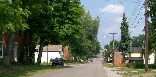
Photo: Bwsmith84, Wikimedia Commons, CC BY 3.0 · Wikimedia Commons
Local history sources: en.wikipedia.org · en.wikipedia.org · en.wikipedia.org · commons.wikimedia.org · archive.org
Water
A well in the Ohio River valley (alluvial) aquifer serving the St. Clairsville-area system The water here
- Morristown Public Water System97% of residentsOhio River valley aquifer (wells)
- Bethesda Public Water System3% of residentsOhio River valley aquifer (wells)
Hospitals, fire stations and more
Inside Morristown's boundary: 1 fire or EMS station, 1 museum and 1 spill case. Press a pin or a name for its whole record and its source.
Fire and EMS stations (1)
-
Morristown Fire Department Station 31Morristown
- Address
- 142 Memory Lane, Morristown, OH 43759
- Coordinates
- 40.06473, -81.07545
USGS National Map structures (source) ↗ Street map and directions ↗
Source: USGS National Map structures (most Ohio records last updated 2019 to 2022), checked against the Columbus and Cleveland station lists. The department that answers a call is set by jurisdiction and mutual aid, not by distance.
Museums, historical societies, gardens and zoos (1)
-
Morristown Historic Preservation AssociationHistorical society · Morristown
- What it is
- Historical society
- City
- Morristown
- Coordinates
- 40.06367, -81.07193
Search Wikipedia ↗ IMLS Museum Data Files (source) ↗ Street map and directions ↗
The museum list is IMLS's 2018 file; a museum may have closed or moved since.
Source: IMLS Museum Data Files, 2018.
Spills reported since 2021 (1)
-
Fuel Diesel / Diesel Fuel (Vehicle On Or Off Road)2025-10-23 · Morristown
- Reported
- 2025-10-23
- What spilled
- Fuel Diesel / Diesel Fuel (Vehicle On Or Off Road)
- Largest amount reported
- 25 gallons
- Where
- Morristown, Belmont County
- Ohio EPA district office
- SEDO
- Ohio EPA case number
- 2510EPA0001739
Ohio EPA spill reports (source) ↗ Street map and directions ↗
Source: Ohio EPA emergency response spill reports, 2021 to September 2026, one point per case where Ohio EPA placed it. A report is what the caller or responder recorded; amounts are often blank or estimated.
Its ZIP codes
Each ZIP code that touches Morristown, with the share of its residents who live here and the same headline figures as the ZIP page.
| ZIP | Share | Water | Radon | Home value | Schools | Flood |
|---|---|---|---|---|---|---|
| 43759 Morristown | 100% | A well in the Ohio River valley (alluvial) aquifer serving the St. Clairsville-area system | Too few radon tests | Median year built 1939 | Union Local · 3 stars overall | 0.0% of residents in the 1% floodplain |
| 43719 Bethesda | 1% | A well in the Ohio River valley (alluvial) aquifer serving the St. Clairsville-area system | 5.7 pCi/L average radon | Median year built 1965 | Union Local · 3 stars overall | 1.1% of residents in the 1% floodplain |
Local government
Who holds office in Morristown, how its elections and ballot issues came out, and the state auditor's record.
Ballot issues
| Date | Issue | For | Against | Result |
|---|---|---|---|---|
| 2021-11-02 | Issue: Morristown Village Marihuana Ordinance | 24 | 27 | Failed (47.06% for), unofficial |
Elections for office
| Date | Office | Candidates and votes |
|---|---|---|
| 2021-11-02 | Village Council (unofficial count) | Bradlee Gibson 35, 29.41%; Pamela R. McCort 35, 29.41%; John J. Rataiczak 35, 29.41%; Write-In: Richard J. Wilhelm 4, 3.36% |
| 2019-11-05 | Village Council | Doug Harris 29, 48.33%; Gordon Price 31, 51.67% |
| 2019-11-05 | Mayor | Heather R. Stitt 32, 100.0% |
| 2017-11-07 | Village Council | Pamela R. McCort 49, 16.67%; John Rataiczak 46, 15.65%; Lowell Akers 43, 14.63%; Michael Mudrak 43, 14.63%; Gene Dewayne Petrey 39, 13.27%; Arthur Henderson 37, 12.59%; Benjamin S. Sall 37, 12.59% |
| 2015-11-03 | Village Council | Doug Harris 58, 58.59%; Write-In: Orie J. Yeary 41, 41.41% |
| 2015-11-03 | Mayor | Heather R. Stitt 54, 55.67%; Write-In: Richard Wilson 43, 44.33% |
Winners in bold. Results from the county board of elections' official canvass unless marked.
Auditor of State record
- No fiscal caution, watch or emergency on the Auditor of State's lists.
- Agreed Upon Procedures, 2023 to 2024, released 2025-09-23
The county
Belmont County: 23 ZIP codes, 29 cities, villages and townships, 64,982 people.
Nearby places
Rain and snow
How much has actually fallen on Morristown, day by day, from 1878 to now. Daily totals, not averages.
- rain, last 30 days
- 2.22 in
- 2026-09-30 to 2026-10-29
- rain so far in 2026
- 44.8 in
- 7.2 in above normal for the date
- snow so far in 2026
- 21.7 in
- a normal year brings 24.8 in
- a normal year
- 44.2 in
- average of 30 years, 1991-2020
| Month | Rain (in) | Snow (in) | Days counted |
|---|---|---|---|
| October 2026 | 2.22 | — | 29 |
| September 2026 | 4.96 | — | 30 |
| August 2026 | 8.76 | — | 31 |
| July 2026 | 3.95 | — | 31 |
| June 2026 | 4.86 | — | 30 |
| May 2026 | 5.80 | — | 31 |
| April 2026 | 4.16 | — | 30 |
| March 2026 | 6.94 | 3.5 | 31 |
| February 2026 | 1.15 | 2.9 | 28 |
| January 2026 | 1.97 | 15.3 | 31 |
| December 2025 | 2.33 | 11.6 | 31 |
| November 2025 | 2.40 | 0.0 | 30 |
| Wettest year | 2018 — 63.0 in |
|---|---|
| Driest year | 1930 — 24.4 in |
| Snowiest year | 1910 — 61.5 in |
| Wettest day on record | 18 September 2004 — 5.00 in |
| Heaviest snowfall in a day | 17 December 1890 — 17.01 in |
| Deepest snow on the ground | 21 January 1978 — 18.86 in |
Estimated, not measured. No rain gauge has ever stood inside Morristown, so every figure here is worked out from the gauges around it - the nearest ones weighted most. Treat them as close estimates rather than readings.
52,014 days of records, 1878-02-01 to 2026-10-29. Source: NOAA NCEI GHCN-Daily, 3,240 gauges in and around Ohio. A day is "gauged" when a gauge standing inside the boundary reported it, and the value is the mean of those gauges. Otherwise it is interpolated by inverse distance from every gauge reporting within 50 miles. Nothing is carried forward, back-filled or smoothed. Against NOAA nClimDiv county monthly precipitation over 136,848 complete county-months (checked 2026-10-31): correlation 0.9515, median absolute difference 0.217 in a month. Built 2026-10-31 from the Cracked Buckeye precipitation archive. Snow is the softer number — snowfall is measured by hand with a ruler, no agency publishes a gridded county snowfall series, and blowing snow defeats every observer.
Quick answers
What county is Morristown, Ohio in?
Morristown is a village in Belmont County, Ohio, with 248 residents.
When was Morristown, Ohio founded?
Morristown was laid out 1802. Founders on record: named for Duncan Morrison. Source
How did Morristown, Ohio get its name?
Named for Duncan Morrison, a pioneer settler; historically also rendered 'Morris Town.' Source
What ZIP code is Morristown, Ohio?
Most of Morristown is in ZIP code 43759.
Where does Morristown, Ohio get its water?
The main water source for Morristown (Morristown Public Water System): A well in the Ohio River valley (alluvial) aquifer serving the St. Clairsville-area system.
Cite this page
Cite this page as:
Cracked Buckeye, "Morristown, Belmont County", https://crackedbuckeye.com/place/morristown/, built 2026-10-31, accessed [date].
How to cite · Report a correction · Built 2026-10-31
