Local events in Bethesda
4 events in the next 90 days from 1 public calendar. All local events in Bethesda
Checked October 20; the events page is refreshed daily.
How Bethesda began
Bethesda grew through three names before settling on its present one. The railroad reached the site in 1852, establishing a station called Burr's Mills for sawmill operator Merrick S. Burr; in 1855 Burr laid out a proper village and named it Fairmount for its high, attractive location. When a storekeeper relocated his business into the new village, the post office moved with him but kept the name of a Bethesda Methodist church about two miles south, and Bethesda became the town's official name by the late 1800s; it incorporated in 1910. Just outside the village, Epworth Park has operated as a Methodist camp-meeting and Chautauqua site since 1878, its lakeside cottages and avenue now recognized as the Epworth Park Historic District.
Settled 1852 (as Burr's Mills), platted 1855 (as Fairmount), incorporated 1910, by Merrick S. Burr.
Where the name comes from
Named for a Bethesda Methodist church about two miles south of the village; when a store owner moved his business into the newly platted town (then called Fairmount), the post office relocated with him but kept the Bethesda name, which became the town's official name by the late 1800s.
Before the town
No Native village, camp, or trail specific to Bethesda was found in the sources consulted.
Timeline
- — The Central Ohio Railroad reaches the site, establishing a station called Burr's Mills after sawmill operator Merrick S. Burr.
- — Burr lays out a village on the site and names it Fairmount for its high, attractive location.
- — Epworth Park, just outside the village, begins operating as a Methodist camp-meeting and Chautauqua site.
- — Bethesda, by then the town's settled name, is formally incorporated as a village.
- — A postcard photograph documents 'The Avenue' running through Epworth Park.
- — The village installs a town clock, made by the E. Howard Watch & Clock Company and mounted atop the Orrison Cigar Co. building on Main Street, dedicated to Bethesda's World War I veterans.
- — Epworth Park's cottages and grounds are added to the National Register of Historic Places as the Epworth Park Historic District.
- — The 1920 town clock is removed from service.
- — The restored clock is rededicated at the new Murray Family Memorial Plaza, honoring veterans of all services.
Stories
A camp meeting that never stopped
In 1878, Methodists began holding camp meetings on a lakeside tract just outside the young village then still known as Fairmount, part of the nationwide Chautauqua movement that combined religious revival with education, music, and rest. What started as a seasonal gathering of tents grew into a fixed settlement of its own: an avenue lined with cottages, a lake for boating and picnics, and enough permanent structures that, well over a century later, the whole grounds were recognized as the Epworth Park Historic District. Postcards from the 1910s show the avenue already well established, its cottages and shade trees drawing visitors year after year. The park has outlasted the name of the village it sits beside changing twice over, and continues to operate today much as it always has, a piece of nineteenth-century religious and recreational life still functioning in the twenty-first.
Photographs
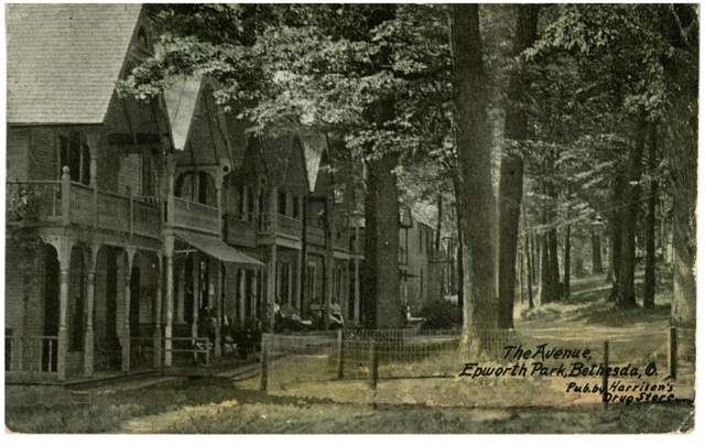
Photo: Columbus Metropolitan Library, via Digital Public Library of America / Ohio Digital Network, public domain · Wikimedia Commons
Local history sources: en.wikipedia.org · en.wikipedia.org · commons.wikimedia.org
Water
A well in the Ohio River valley (alluvial) aquifer serving the St. Clairsville-area system The water here
- Bethesda Public Water System97% of residentsOhio River valley aquifer (wells)
- Morristown Public Water System3% of residentsOhio River valley aquifer (wells)
Hospitals, fire stations and more
Inside Bethesda's boundary: 1 fire or EMS station, 1 library and 2 spill cases. Press a pin or a name for its whole record and its source.
Fire and EMS stations (1)
-
Bethesda Fire and Rescue Station 18Bethesda
- Address
- 103 East Spring Street, Bethesda, OH 43719
- Coordinates
- 40.01539, -81.07123
USGS National Map structures (source) ↗ Street map and directions ↗
Source: USGS National Map structures (most Ohio records last updated 2019 to 2022), checked against the Columbus and Cleveland station lists. The department that answers a call is set by jurisdiction and mutual aid, not by distance.
Public libraries (1)
-
Bethesda BranchBranch · Bethesda
- Address
- 112 N. Main Street, Bethesda, OH 43719
- What it is
- Branch
- Library system
- Belmont County District Library
- Open
- 1,872 hours a year, 52 weeks
- Building
- 1,300 sq ft
- System's visits, FY2024
- 74,932
- System's loans, FY2024
- 114,482
- People the system serves
- 33,295
- Phone
- (740) 484-4532
IMLS Public Libraries Survey (source) ↗ Street map and directions ↗
Source: IMLS Public Libraries Survey FY2024 (outlets and their systems). Any Ohio resident can get a free card at any Ohio public library.
Spills reported since 2021 (2)
-
Chemical(S) Unk2022-11-09 · Bethesda
- Reported
- 2022-11-09
- What spilled
- Chemical(S) Unk
- Where
- Bethesda, Belmont County
- Ohio EPA district office
- SEDO
- Ohio EPA case number
- 2211EPA0001667
Ohio EPA spill reports (source) ↗ Street map and directions ↗
-
Bentonite / Drilling Mud2022-08-26 · Bethesda
- Reported
- 2022-08-26
- What spilled
- Bentonite / Drilling Mud
- Largest amount reported
- 250 gallons
- Where
- Bethesda, Belmont County
- Ohio EPA district office
- SEDO
- Ohio EPA case number
- 2208EPA0001316
Ohio EPA spill reports (source) ↗ Street map and directions ↗
Source: Ohio EPA emergency response spill reports, 2021 to September 2026, one point per case where Ohio EPA placed it. A report is what the caller or responder recorded; amounts are often blank or estimated.
Its ZIP codes
Each ZIP code that touches Bethesda, with the share of its residents who live here and the same headline figures as the ZIP page.
| ZIP | Share | Water | Radon | Home value | Schools | Flood |
|---|---|---|---|---|---|---|
| 43719 Bethesda | 52% | A well in the Ohio River valley (alluvial) aquifer serving the St. Clairsville-area system | 5.7 pCi/L average radon | Median year built 1965 | Union Local · 3 stars overall | 1.1% of residents in the 1% floodplain |
Local government
Who holds office in Bethesda, how its elections and ballot issues came out, and the state auditor's record.
Money issues on the ballot since 2018: 1 of 1 passed.
Ballot issues
| Date | Issue | For | Against | Result |
|---|---|---|---|---|
| 2018-11-06 | Issue: Bethesda Village - Fire - Renewal | 285 | 125 | Passed (69.51% for) |
| 2018-05-08 | Issue: Bethesda Village General Construction - Renewal Levy | 102 | 38 | Passed (72.86% for) |
| 2015-11-03 | Issue: Precinct 049 Village of Bethesda - Local Liquor Option Sunday Sales C1 & C2 Permit | 283 | 115 | Passed (71.11% for) |
| 2015-11-03 | Issue: Precinct 049 Village of Bethesda - Local Liquor Option Sunday Sales D6 Permit | 250 | 148 | Passed (62.81% for) |
Elections for office
| Date | Office | Candidates and votes |
|---|---|---|
| 2021-11-02 | Village Council (unofficial count) | Jordan L. Castello 95, 12.03%; Zachery Gaston 107, 13.54%; Joshua Haught 68, 8.61%; Charles R. Little 102, 12.91%; Carol A. Merritt 104, 13.16%; Linda Reeves 91, 11.52%; Ruth A. Saffell 111, 14.05%; Jay Van Horn 112, 14.18% |
| 2019-11-05 | Village Council | Cynthia L. Foose 194, 100.0% |
| 2019-11-05 | Mayor | Samantha M. Burkhead 136, 49.1%; Jordan L. Castello 40, 14.44%; Linda Reeves 101, 36.46% |
| 2017-11-07 | Village Council | Paul M. Fitch 156, 19.62%; Carol Ann Merritt 154, 19.37%; Brian James Bee 141, 17.74%; Jordan Castello 136, 17.11%; Linda Reeves 126, 15.85%; Lance Richards 82, 10.31% |
| 2015-11-03 | Village Council | Cynthia L. Foose 179, 32.14%; Charles Little 197, 35.37%; Austin D. Lucas 181, 32.5% |
| 2015-11-03 | Mayor | Pete Bendo 146, 36.87%; Martin W. Lucas 250, 63.13% |
Winners in bold. Results from the county board of elections' official canvass unless marked.
The county
Belmont County: 23 ZIP codes, 29 cities, villages and townships, 64,982 people.
Nearby places
Rain and snow
How much has actually fallen on Bethesda, day by day, from 1878 to now. Daily totals, not averages.
- rain, last 30 days
- 2.32 in
- 2026-10-01 to 2026-10-30
- rain so far in 2026
- 45.3 in
- 7.2 in above normal for the date
- snow so far in 2026
- 21.8 in
- a normal year brings 25.5 in
- a normal year
- 44.8 in
- average of 30 years, 1991-2020
| Month | Rain (in) | Snow (in) | Days counted |
|---|---|---|---|
| October 2026 | 2.32 | — | 30 |
| September 2026 | 5.06 | — | 30 |
| August 2026 | 8.54 | — | 31 |
| July 2026 | 4.16 | — | 31 |
| June 2026 | 5.00 | — | 30 |
| May 2026 | 5.92 | — | 31 |
| April 2026 | 4.19 | — | 30 |
| March 2026 | 6.95 | 3.6 | 31 |
| February 2026 | 1.17 | 3.3 | 28 |
| January 2026 | 2.05 | 14.9 | 31 |
| December 2025 | 2.33 | 11.0 | 31 |
| November 2025 | 2.39 | 0.0 | 30 |
| Wettest year | 2018 — 62.8 in |
|---|---|
| Driest year | 1930 — 24.4 in |
| Snowiest year | 1910 — 58.5 in |
| Wettest day on record | 18 September 2004 — 5.04 in |
| Heaviest snowfall in a day | 17 December 1890 — 17.01 in |
| Deepest snow on the ground | 18 February 2003 — 19.17 in |
Estimated, not measured. No rain gauge has ever stood inside Bethesda, so every figure here is worked out from the gauges around it - the nearest ones weighted most. Treat them as close estimates rather than readings.
51,998 days of records, 1878-02-01 to 2026-10-30. Source: NOAA NCEI GHCN-Daily, 3,240 gauges in and around Ohio. A day is "gauged" when a gauge standing inside the boundary reported it, and the value is the mean of those gauges. Otherwise it is interpolated by inverse distance from every gauge reporting within 50 miles. Nothing is carried forward, back-filled or smoothed. Against NOAA nClimDiv county monthly precipitation over 136,848 complete county-months (checked 2026-11-01): correlation 0.9515, median absolute difference 0.217 in a month. Built 2026-11-01 from the Cracked Buckeye precipitation archive. Snow is the softer number — snowfall is measured by hand with a ruler, no agency publishes a gridded county snowfall series, and blowing snow defeats every observer.
Environmental permits and filings
What Ohio EPA has on file for Bethesda: permits, inspections, violations, cleanups and the state loans behind sewer and water work. Every line links to the agency's own document.
- facilities and sites on file
- 2
- those placed on the map inside Bethesda
| Program | Facilities and sites |
|---|---|
| Public drinking water | 1 |
| State water loans | 1 |
| Date | Facility or site | What |
|---|---|---|
| BETHESDA PUBLIC WATER SYSTEM PWS | Public drinking water compliance letter | |
| BETHESDA PUBLIC WATER SYSTEM PWS | Public drinking water plan | |
| BETHESDA PUBLIC WATER SYSTEM PWS | Public drinking water report | |
| BETHESDA PUBLIC WATER SYSTEM PWS | Public drinking water inspection | |
| BETHESDA PUBLIC WATER SYSTEM PWS | Public drinking water inspection | |
| BETHESDA PUBLIC WATER SYSTEM PWS | Public drinking water compliance letter | |
| BETHESDA PUBLIC WATER SYSTEM PWS | Public drinking water report | |
| BETHESDA PUBLIC WATER SYSTEM PWS | Public drinking water notice of violation | |
| BETHESDA PUBLIC WATER SYSTEM PWS | Public drinking water compliance letter | |
| BETHESDA PUBLIC WATER SYSTEM PWS | Public drinking water report | |
| BETHESDA PUBLIC WATER SYSTEM PWS | Public drinking water warning letter | |
| BETHESDA PUBLIC WATER SYSTEM PWS | Public drinking water warning letter | |
| BETHESDA PUBLIC WATER SYSTEM PWS | Public drinking water notice of violation | |
| BETHESDA PUBLIC WATER SYSTEM PWS | Public drinking water compliance letter | |
| BETHESDA PUBLIC WATER SYSTEM PWS | Public drinking water violation resolved | |
| BETHESDA PUBLIC WATER SYSTEM PWS | Public drinking water compliance letter | |
| BETHESDA PUBLIC WATER SYSTEM PWS | Public drinking water notice of violation | |
| BETHESDA PUBLIC WATER SYSTEM PWS | Public drinking water compliance letter | |
| BETHESDA PUBLIC WATER SYSTEM PWS | Public drinking water inspection | |
| BETHESDA PUBLIC WATER SYSTEM PWS | Public drinking water report | |
| BETHESDA PUBLIC WATER SYSTEM PWS | Public drinking water notice of violation | |
| BETHESDA PUBLIC WATER SYSTEM PWS | Public drinking water compliance letter | |
| BETHESDA PUBLIC WATER SYSTEM PWS | Public drinking water permit | |
| BETHESDA PUBLIC WATER SYSTEM PWS | Public drinking water notice of violation | |
| BETHESDA PUBLIC WATER SYSTEM PWS | Public drinking water compliance letter |
Source: Ohio EPA eDocument portal (edocpub.epa.ohio.gov), indexed 2026-10-14. Facilities are placed on the map from Ohio EPA's own map layers, EPA's Facility Registry, coordinates written in the filings, or a geocoded street address. A permit filed under a private person's name (most are household septic systems) is counted but never named, placed or linked; licenses for individual workers and open-burning notices are left out entirely.
Quick answers
What county is Bethesda, Ohio in?
Bethesda is a village in Belmont County, Ohio, with 1,211 residents.
When was Bethesda, Ohio founded?
Bethesda was settled 1852 (as Burr's Mills); laid out 1855 (as Fairmount); incorporated 1910. Founders on record: Merrick S. Burr. Source
How did Bethesda, Ohio get its name?
Named for a Bethesda Methodist church about two miles south of the village; when a store owner moved his business into the newly platted town (then called Fairmount), the post office relocated with him but kept the Bethesda name, which became the town's official name by the late 1800s. Source
What ZIP code is Bethesda, Ohio?
Most of Bethesda is in ZIP code 43719.
Where does Bethesda, Ohio get its water?
The main water source for Bethesda (Bethesda Public Water System): A well in the Ohio River valley (alluvial) aquifer serving the St. Clairsville-area system.
Cite this page
Cite this page as:
Cracked Buckeye, "Bethesda, Belmont County", https://crackedbuckeye.com/place/bethesda/, built 2026-10-31, accessed [date].
How to cite · Report a correction · Built 2026-10-31