Local events in Monroe Township, Adams County
Nothing is posted for Monroe Township itself yet; here is what is on within 20 miles. All local events in Monroe Township, Adams County
Know a calendar we should watch? Send the link
Checked October 20; the events page is refreshed daily.
How Monroe Township, Adams County began
Monroe Township, on the Ohio River in southern Adams County, was cut from the south end of Tiffin Township on June 23, 1817, and named for President James Monroe. It holds some of the county's oldest settlement: Gift Ridge, where Nathaniel Massie gave the first Manchester colonists 100-acre farms, was being cleared in 1795, and Massie's own Buckeye Station stands on the river bluff below Wrightsville. Noble Grimes laid out the town of Washington at the mouth of Ohio Brush Creek in 1798, and it served for several years as the county seat. The township also contains two precontact sites listed on the National Register in 1974, the Wamsley Village Site and a mound on the Killen power station grounds near the mouth of Brush Creek.
Settled 1795, platted 1798, incorporated 1817, by John Yochum and Zephaniah Wade settled on Gift Ridge in 1795; Noble Grimes laid out Washington in 1798; the township was organized June 23, 1817.
Where the name comes from
Named in honor of James Monroe, who had lately been elected the fifth President of the United States when the township was formed in 1817.
Before the town
The Wamsley Village Site, on the grounds of the Dayton Power and Light Company's Killen Station near the mouth of Brush Creek west of Stout, and a separate Dayton Power and Light Company Mound on the same property were both listed on the National Register on July 30, 1974; burials have been documented at the village site, but its cultural affiliation could not be confirmed from a source. The 1880 county atlas records a mound a few rods below the village of Wrightsville on the Ohio River bank, which the river was washing away, with human remains and pottery fragments visible in the eroding bank. By the same account, Nathaniel Massie, Israel Donaldson and their party were standing on that mound on the morning of April 21, 1791, when Indians approached them from behind in canoes on the river; the party scattered for the hills, and Donaldson, falling into a run some fifty rods away, was the one left behind, and the stream has been called Donaldson's Run since. The atlas also says Indians were said to watch for boats descending the river from the high point later called Buckeye Station.
- Wamsley Village Site (village) — west of Stout, near the mouth of Brush Creek, on the DP&L Killen Station grounds, Monroe Township, precontact (cultural affiliation not confirmed) (en.wikipedia.org)
- Dayton Power and Light Company Mound (mound) — Monroe Township, on the DP&L Killen Station grounds, precontact (cultural affiliation not confirmed) (en.wikipedia.org)
- Mound below Wrightsville (burial) — on the Ohio River bank a few rods below Wrightsville, Monroe Township (largely washed away by 1880), precontact (not dated in the source) (archive.org)
- Donaldson's capture, 1791 (battle) — near the mound below Wrightsville and Donaldson's Run, Monroe Township, April 21, 1791 (archive.org)
Timeline
- — On April 21 a party of Indians in canoes surprised Nathaniel Massie, Israel Donaldson and others on a mound near the later Wrightsville; Donaldson was the one left behind, and Donaldson's Run took his name.
- — John Yochum, an assistant to Massie and other surveyors, began clearing on Gift Ridge, sheltering under two large rocks later shown as Yochum's Hermitage.
- — Christiana Wade, daughter of Zephaniah Wade, was born on Gift Ridge on November 20, probably the first white child born in the county outside the Manchester stockade.
- — Nathaniel Washburn settled at the head of Donalson Creek and soon built a small mill, and the Grimes family settled at the mouth of Ohio Brush Creek.
- — Buckeye Station was built on the 1,000 acres Nathaniel Massie reserved on the table-land above the Ohio about a mile below the later Wrightsville.
- — Buckeye Station's present one-and-a-half-story house was built by Massie, who later sold the property to his brother-in-law Charles Willing Byrd.
- — Noble Grimes laid out the town of Washington at the mouth of Ohio Brush Creek, for several years the seat of justice of Adams County.
- — A boy was killed after being caught in the machinery of Nathaniel Washburn's mill on Donaldson's Creek.
- — The township's first schoolhouse was built on the Lewis Bible farm with James Lane as teacher; a second, on Arthur Ellison's farm, was called the 'State House' because township business was done there.
- — Rev. James Quinn preached what is believed to be the township's first sermon at William Lucas's house on Gift Ridge, the start of the Methodist class later called Quinn's Chapel.
- — The township was formed on June 23 from the south end of Tiffin, and its first election was held at Arthur Ellison's house on the last Saturday in July.
- — James Hobson laid out Wrightsville on the Ohio River about six miles above Manchester on April 22; its post office, first called Mahala, was later renamed Vineyard Hill.
- — Quinn's Chapel replaced its hewed-log meeting house with a frame building on John Pennywitt's farm.
- — Union Chapel Methodist Episcopal church was organized on Ohio Brush Creek near the mouth of Beasley's Fork.
- — Beasley's Fork post office was established with James Miller as postmaster.
- — The township's population was 1,400, up from 828 in 1840.
- — Buckeye Station, the Wamsley Village Site and the Dayton Power and Light Company Mound were listed on the National Register of Historic Places.
Stories
A shooting match for a spring
When Massie's colonists took up their gift farms on Gift Ridge, Zephaniah Wade and Jacob Yocum both wanted the same lot, for the sake of a fine spring on it. To settle it they agreed to shoot at a mark for first choice, setting their target against a white oak beside the road near the spring. Wade won, built his house by the spring, and there on November 20, 1795, his daughter Christiana was born, later Mrs. Trenary of Manchester. The 1880 atlas reports the oak still standing and healthy then, with the healed-over scars where the bullets had been chopped out of the wood still visible.
Buckeye Station
Before giving out the bounty farms he had promised the first Manchester settlers, Nathaniel Massie reserved 1,000 acres for his own farm, about four miles up the river from Manchester and a mile below the later Wrightsville. Its southern point, a high bluff commanding the Ohio for miles, was called Buckeye Station; the 1880 atlas says Indians had been known to watch there for boats coming downriver, and that Massie built a stockade and blockhouse and moved his family to it. He did not stay long, selling to Charles Willing Byrd, who lived there before 1809; later owners included Thomas Jones and John Ellison, after whose money troubles the land was sold off in parcels. By 1880 it was owned by several parties.
Captain Faulkner and the hearthstone
Captain William Faulkner, or Falconer, a soldier of the Revolution and the War of 1812, was an early settler at the mouth of Ohio Brush Creek and is buried in the old orchard on the Grimes farm. The 1900 county history records that when his wife died he buried her at the chimney of his house, then built a new hearth and laid the hearthstone over her grave, and that he would sprinkle water on the stone and speak to her. The same pages record Henry Malone, born near the mouth of Brush Creek in 1815, recalling that as a boy of about eight he earned his first money, six and a quarter cents, ferrying a young preacher across the creek in his father's canoe. The preacher was Henry Bascom, then giving his first sermons in the county, and Malone said he gave the coin to his mother to help keep an old neighbor from being sold as a pauper under the law of the day.
Photographs
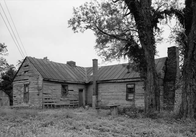
Photo: Wikimedia Commons file cropped from a survey photograph titled "EXTERIOR, NORTHWEST VIEW - General Nathaniel Massie House", public domain · Wikimedia Commons
Local history sources: en.wikipedia.org · archive.org · archive.org · archive.org · archive.org · archive.org · en.wikipedia.org · en.wikipedia.org · en.wikipedia.org · geocoding.geo.census.gov · geocoding.geo.census.gov · geocoding.geo.census.gov · commons.wikimedia.org
Historic places
1 place in Monroe Township, Adams County on the National Register of Historic Places. Press a pin or a name for its whole record.
-
Buckeye StationBuilding · Manchester · listed 1974
- Address
- E of Manchester off U.S. 52
- Where
- Manchester, Adams County · ZIP 45144
- What it is
- Building
- Listed on the National Register
- 1974
- NRIS reference number
- 74001388
- Coordinates
- 38.70633, -83.54186
National Register file (NPS) ↗ Search Wikipedia ↗ Street map and directions ↗ On the Cracked Buckeye map
Source: National Park Service, National Register of Historic Places point file. The listing year is shown where NPS's certification date agrees with the listing's reference number. Listing recognizes significance; it does not restrict a private owner.
Water
Groundwater wells (2 wells) The water here
- Manchester Village66% of residentsGroundwater wells (2 wells)
- West Union Public Water System20% of residentsOhio River Valley Aquifer (wells near Manchester)
- Adams County Regional Wd14% of residentsOhio River Valley Aquifer (wells near Manchester)
Hospitals, fire stations and more
Inside Monroe Township, Adams County's boundary: 1 fire or EMS station, 1 high-hazard dam, 2 poor-rated bridges, 2 Toxics Release Inventory facilities and 2 spill cases. Press a pin or a name for its whole record and its source.
Fire and EMS stations (1)
-
Monroe Township Volunteer Fire Department Station 14Manchester
- Address
- 2426 State Highway 247, Manchester, OH 45144
- Coordinates
- 38.73471, -83.51623
USGS National Map structures (source) ↗ Street map and directions ↗
Source: USGS National Map structures (most Ohio records last updated 2019 to 2022), checked against the Columbus and Cleveland station lists. The department that answers a call is set by jurisdiction and mutual aid, not by distance.
High-hazard dams (1)
-
Killen Station Ash Disposal DikeOhio River - Offstream · condition: fair
- Hazard class
- High: a failure would probably cost a life
- Condition
- Fair (assessed 03/27/2024)
- River or stream
- Ohio River - Offstream
- Purpose
- Tailings
- Type
- Earth
- Height
- 84 ft
- Storage
- 12,890 acre-feet
- Completed
- 1982
- Owner type
- Public Utility
- County
- Adams County
- Nearest town (NID)
- Concord
- Last inspection
- 06/08/2023
- Emergency action plan
- No
- NID ID
- OH01127
National Inventory of Dams record ↗ National Inventory of Dams (source) ↗ Street map and directions ↗
Source: U.S. Army Corps of Engineers National Inventory of Dams, August 2026. "High hazard" rates what a failure would cost downstream, not how likely one is; the condition is the state's assessment.
Bridges rated poor (2)
-
Brush Creek Road over Brush Creek CreekPoor · built 1910
- Condition
- Poor: a deck, superstructure, substructure or culvert rated 4 or below on the 0 to 9 scale
- What it is
- Bridge
- Built
- 1910
- Length
- 36 ft
- Owner
- County
- Vehicles a day
- 44
- Coordinates
- 38.74384, -83.49536
National Bridge Inventory (source) ↗ Street map and directions ↗
-
Buckeyestation Rd. over Donaldson CreekPoor · built 2002
- Condition
- Poor: a deck, superstructure, substructure or culvert rated 4 or below on the 0 to 9 scale
- What it is
- Bridge
- Built
- 2002
- Length
- 11 ft
- Owner
- County
- Vehicles a day
- 105
- Coordinates
- 38.71164, -83.53294
National Bridge Inventory (source) ↗ Street map and directions ↗
Source: FHWA National Bridge Inventory 2025. "Poor" means one major part rated 4 or below on the 0 to 9 scale; it calls for repair, not closing, unless the state posts or closes the bridge.
Facilities reporting toxic releases (2)
-
Dayton Power & Light Co Killen StationToxics Release Inventory · Manchester
- Address
- 14869 Us 52, Manchester, OH 45144
- County
- Adams County
- Status
- Reports to the Toxics Release Inventory (open)
- EPA program ID
- 45144DYTNP14869
- EPA registry ID
- 110000591841
EPA facility record ↗ EPA Facility Registry Service (source) ↗ Street map and directions ↗
-
Ershigs Killen ProjectToxics Release Inventory · Manchester
- Address
- 14869 U.S. Rt 52, Manchester, OH 45144
- County
- Adams County
- Status
- Reports to the Toxics Release Inventory (closed)
- EPA program ID
- 45144RSHGS14869
- EPA registry ID
- 110031019635
EPA facility record ↗ EPA Facility Registry Service (source) ↗ Street map and directions ↗
Source: EPA Facility Registry Service, Toxics Release Inventory reporters. Reporting a release is required of large users of listed chemicals; it is not by itself a violation.
Spills reported since 2021 (2)
-
Oil Petroleum Not Otherwise Specified (Nos)2023-03-29 · Monroe Twp
- Reported
- 2023-03-29
- What spilled
- Oil Petroleum Not Otherwise Specified (Nos)
- Where
- Monroe Twp, Adams County
- Ohio EPA district office
- SEDO
- Ohio EPA case number
- 2303EPA0000470
Ohio EPA spill reports (source) ↗ Street map and directions ↗
-
Fish Kill Reached water2026-06-16 · Monroe Twp
- Reported
- 2026-06-16
- What spilled
- Fish Kill
- Reached a waterway
- 01 - Spring Run
- Where
- Monroe Twp, Adams County
- Ohio EPA district office
- SWDO
- Ohio EPA case number
- 2606EPA0001070
Ohio EPA spill reports (source) ↗ Street map and directions ↗
Source: Ohio EPA emergency response spill reports, 2021 to September 2026, one point per case where Ohio EPA placed it. A report is what the caller or responder recorded; amounts are often blank or estimated.
Its ZIP codes
Each ZIP code that touches Monroe Township, Adams County, with the share of its residents who live here and the same headline figures as the ZIP page.
| ZIP | Share | Water | Radon | Home value | Schools | Flood |
|---|---|---|---|---|---|---|
| 45144 Manchester | 11% | Groundwater wells (2 wells) | 2.2 pCi/L average radon | Median year built 1970 | Manchester Local · 3.5 stars overall | 26% of residents in the 1% floodplain |
| 45693 West Union | 2% | Mostly private wells | 0.8 pCi/L average radon | Median year built 1978 | Adams County/Ohio Valley Local · 3 stars overall | 0.5% of residents in the 1% floodplain |
Local government
Who holds office in Monroe Township, Adams County, how its elections and ballot issues came out, and the state auditor's record.
Elections for office
| Date | Office | Candidates and votes |
|---|---|---|
| 2019-11-05 | Township Trustee | Brenda Emery 84, 100.0% |
| 2019-11-05 | Township Fiscal Officer | Angela Wikoff 87, 100.0% |
Winners in bold. Results from the county board of elections' official canvass unless marked.
Auditor of State record
- No fiscal caution, watch or emergency on the Auditor of State's lists.
- Agreed Upon Procedures, 2022 to 2023, released 2024-10-22
The county
Adams County: 9 ZIP codes, 19 cities, villages and townships, 30,224 people.
Nearby places
Quick answers
What county is Monroe Township, Ohio in?
Monroe Township, Adams County is a township in Adams County, Ohio, with 609 residents.
When was Monroe Township, Ohio founded?
Monroe Township, Adams County was settled 1795; laid out 1798; incorporated 1817. Founders on record: John Yochum and Zephaniah Wade settled on Gift Ridge in 1795; Noble Grimes laid out Washington in 1798; the township was organized June 23, 1817. Source
How did Monroe Township, Ohio get its name?
Named in honor of James Monroe, who had lately been elected the fifth President of the United States when the township was formed in 1817. Source
What ZIP code is Monroe Township, Ohio?
Most of Monroe Township, Adams County is in ZIP code 45144.
Where does Monroe Township, Ohio get its water?
The main water source for Monroe Township, Adams County (Manchester Village): Groundwater wells (2 wells).
Cite this page
Cite this page as:
Cracked Buckeye, "Monroe Township, Adams County", https://crackedbuckeye.com/place/monroe-township-adams-county/, built 2026-10-31, accessed [date].
How to cite · Report a correction · Built 2026-10-31