Local events in Oliver Township, Adams County
Nothing is posted for Oliver Township itself yet; here is what is on within 20 miles. All local events in Oliver Township, Adams County
Know a calendar we should watch? Send the link
Checked October 20; the events page is refreshed daily.
How Oliver Township, Adams County began
Oliver Township, one of Adams County's two inland townships, was organized on March 8, 1853, from parts of Wayne and Tiffin and of Scott (or Meigs, by the 1880 atlas) townships, and named for John Oliver, then a county commissioner. Its first settlers came to Cherry Fork of Ohio Brush Creek between 1805 and 1808, among them John Clark, Samuel Wright and Robert Finley. Three small villages grew up: Dunkinsville (laid out 1841), Unity (around a United Presbyterian church organized in 1846) and Harshaville, which formed around the Harsha flouring mills on Cherry Fork and is the site of the 1855 Harshaville Covered Bridge. The township is remembered in county history for the 1855 murder of William and Nancy Senter near Unity.
Settled 1805, platted 1841, incorporated 1853, by John Clark is named as among the first settlers; Dunkinsville was laid out December 14, 1841; the township was organized March 8, 1853.
Where the name comes from
Named in honor of John Oliver, a resident who was a member of the Board of County Commissioners when the township was organized in 1853.
Before the town
Neither the 1880 atlas nor the 1900 county history records a Native village, mound or event specific to Oliver Township; the Cherry Fork valley's first recorded occupants in those works are the white settlers of 1805-1808.
Timeline
- — John Clark settled on the Clark farm west of the later village of Harshaville, one of the township's first settlers (the 1880 atlas dates his arrival to the fall of 1806).
- — Samuel Wright settled where Harshaville now stands, and Robert Finley took up the later Nathaniel Patton farm; James Hemphill ran a small mill and a still-house near the mouth of George's Creek.
- — Lick Fork Baptist Church was organized, first meeting in a log building replaced by a frame church in 1857.
- — Dunkinsville, near the mouth of Lick Fork on the West Union and Peebles pike, was laid out on December 14 in eighteen lots.
- — The Unity United Presbyterian congregation was organized at the house of George Clark and built a frame church in 1847; the hamlet of Unity grew up around it.
- — Wheat Ridge post office was established at Unity in January with William B. Brown as postmaster, named for the ridge's heavy wheat crops.
- — Oliver Township was organized on March 8, with a first election at William B. Brown's house in Unity in April.
- — The Harshaville Covered Bridge, a 110-foot Burr-truss span, was built over Cherry Fork at Harshaville.
- — William H. Senter and his wife Nancy were murdered with an ax in their cabin near Unity on November 26 by Alexander Milligan, who had contracted to buy their farm.
- — Milligan was tried at West Union before Judge S.F. Norris, convicted of second-degree murder and sentenced to the penitentiary for life.
- — Confederate raiders under John Hunt Morgan ransacked the Harshaville general store but spared the covered bridge.
- — Members of the Unity United Presbyterian church lost an estimated seven or eight thousand dollars in property to Morgan's raiders.
- — A post office was established at Harshaville on June 30 with George A. Patton as postmaster.
- — The township's population was 1,064 at the 1880 census.
- — The Harshaville Covered Bridge was listed on the National Register of Historic Places; the NRHP list places it in Oliver Township.
Stories
The Senter murder at Unity
In the fall of 1855 William H. Senter and his wife Nancy lived in a round-log cabin near Unity and had offered their small farm for sale. Clinton Dixon of Brown County introduced them to Alexander Milligan, a young Englishman who agreed to buy the farm and its stock for $1,000, payable December 1, and boarded with them meanwhile. When the Senters vanished, Milligan told neighbors they had gone visiting; he then posed as Senter before a Monroe Township justice to have a deed drawn to himself. Harshaville merchant George A. Patton, whom Senter owed money, grew suspicious, neighbors demanded an arrest, and on December 6 searchers found blood in the cabin and the couple's bodies buried under logs and brush in the spring branch. Milligan was tried in November 1856, convicted of second-degree murder, and died in the penitentiary a few years later.
Harshaville and its bridge
Harshaville grew up around an early gristmill on Cherry Fork built by the Harsha family, whose name the hamlet and its bridge carry. In 1855 a covered bridge with a 110-foot Burr-truss span was built over the creek there, on stone abutments; the Ohio Historic Places Dictionary later called it an outstanding example of the type. In the summer of 1863 Confederate cavalry under John Hunt Morgan came through, ransacked the Harshaville general store and burned many bridges in the region, but left this one standing. The bridge was listed on the National Register in 1976, and in 2010 a $100,000 federal grant was awarded to rehabilitate it, including replacing its metal siding with wood.
Photographs
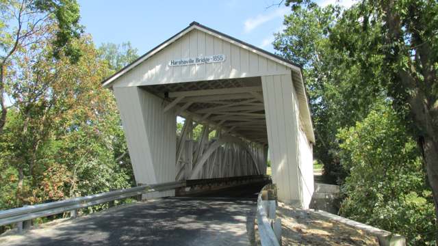
Photo: Aesopposea (Wikimedia Commons user), own work, CC BY-SA 3.0 · Wikimedia Commons
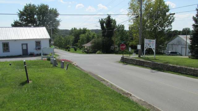
Photo: Aesopposea (Wikimedia Commons user), own work, CC BY-SA 3.0 · Wikimedia Commons
Local history sources: archive.org · archive.org · archive.org · archive.org · archive.org · en.wikipedia.org · en.wikipedia.org · en.wikipedia.org · en.wikipedia.org · en.wikipedia.org · en.wikipedia.org · en.wikipedia.org · geocoding.geo.census.gov · commons.wikimedia.org · commons.wikimedia.org
Historic places
1 place in Oliver Township, Adams County on the National Register of Historic Places. Press a pin or a name for its whole record.
-
Harshaville Covered BridgeStructure · Harshaville · listed 1976
- Address
- SR 1
- Where
- Harshaville, Adams County · ZIP 45660
- What it is
- Structure
- Listed on the National Register
- 1976
- NRIS reference number
- 76001357
- Coordinates
- 38.90791, -83.54442
National Register file (NPS) ↗ Search Wikipedia ↗ Street map and directions ↗ On the Cracked Buckeye map
Source: National Park Service, National Register of Historic Places point file. The listing year is shown where NPS's certification date agrees with the listing's reference number. Listing recognizes significance; it does not restrict a private owner.
Water
Mostly private wells The water here
- West Union Public Water System57% of residentsOhio River Valley Aquifer (wells near Manchester)
- Adams County Regional Wd23% of residentsOhio River Valley Aquifer (wells near Manchester)
- Peebles Public Water System16% of residentsOhio River Valley Aquifer (wells near Manchester)
- Winchester Public Water System3% of residentsOhio River Valley Aquifer (wells near Manchester)
- Seaman Village1% of residentsOhio River Valley Aquifer (wells near Manchester)
Hospitals, fire stations and more
Inside Oliver Township, Adams County's boundary: 1 public charging site and 1 spill case. Press a pin or a name for its whole record and its source.
Public EV charging (1)
-
Murphin Ridge Inn, a Select Registry Property - Tesla Destination2 Level 2 · West Union
- Address
- 750 Murphin Ridge Rd, West Union, OH 45693
- Ports
- 2 Level 2
- Plugs
- J1772, Tesla (NACS)
- Network
- Tesla Destination
- Phone
- 877-798-3752
Station Locator (NREL) ↗ Alternative Fuels Data Center (source) ↗ Street map and directions ↗
Source: NREL Alternative Fuels Data Center station list (May 2026), public and open stations, the posts at one address counted as one site.
Spills reported since 2021 (1)
-
Fuel Diesel / Diesel Fuel (Vehicle On Or Off Road)2025-04-22 · Oliver Twp
- Reported
- 2025-04-22
- What spilled
- Fuel Diesel / Diesel Fuel (Vehicle On Or Off Road)
- Largest amount reported
- 35 gallons
- Where
- Oliver Twp, Adams County
- Ohio EPA district office
- SWDO
- Ohio EPA case number
- 2504EPA0000608
Ohio EPA spill reports (source) ↗ Street map and directions ↗
Source: Ohio EPA emergency response spill reports, 2021 to September 2026, one point per case where Ohio EPA placed it. A report is what the caller or responder recorded; amounts are often blank or estimated.
Its ZIP codes
Each ZIP code that touches Oliver Township, Adams County, with the share of its residents who live here and the same headline figures as the ZIP page.
| ZIP | Share | Water | Radon | Home value | Schools | Flood |
|---|---|---|---|---|---|---|
| 45693 West Union | 9% | Mostly private wells | 0.8 pCi/L average radon | Median year built 1978 | Adams County/Ohio Valley Local · 3 stars overall | 0.5% of residents in the 1% floodplain |
| 45660 Meigs Township and Peebles | 5% | Mostly private wells | 5.0 pCi/L average radon | Median year built 1981 | Adams County/Ohio Valley Local · 3 stars overall | 2.0% of residents in the 1% floodplain |
| 45697 Wayne Township and Winchester | 2% | Mostly private wells | 4.7 pCi/L average radon | Median year built 1990 | Adams County/Ohio Valley Local · 3 stars overall | 0.0% of residents in the 1% floodplain |
| 45679 Scott Township and Seaman | 1% | Mostly private wells | Too few radon tests | Median year built 1976 | Adams County/Ohio Valley Local · 3 stars overall | 1.2% of residents in the 1% floodplain |
Local government
Who holds office in Oliver Township, Adams County, how its elections and ballot issues came out, and the state auditor's record.
Money issues on the ballot since 2020: 1 of 2 passed; of those asking for new or higher taxes, 1 of 2.
Ballot issues
| Date | Issue | For | Against | Result |
|---|---|---|---|---|
| 2024-11-05 | Issue: Oliver Township Road Repairs | 200 | 255 | Failed (43.96% for) |
| 2020-11-03 | Issue: Oliver Township for the purpose of road maintenance | 243 | 231 | Passed (51.27% for) |
Elections for office
| Date | Office | Candidates and votes |
|---|---|---|
| 2019-11-05 | Township Trustee | Bradley Erwin 38, 17.92%; Eric Osman 49, 23.11%; Jeff Roades 75, 35.38%; John Ruggles 50, 23.58% |
| 2019-11-05 | Township Fiscal Officer | Debra A. Rigdon 189, 100.0% |
Winners in bold. Results from the county board of elections' official canvass unless marked.
Auditor of State record
- No fiscal caution, watch or emergency on the Auditor of State's lists.
- Agreed Upon Procedures, 2022 to 2023, released 2024-09-10
The county
Adams County: 9 ZIP codes, 19 cities, villages and townships, 30,224 people.
Nearby places
Quick answers
What county is Oliver Township, Ohio in?
Oliver Township, Adams County is a township in Adams County, Ohio, with 1,352 residents.
When was Oliver Township, Ohio founded?
Oliver Township, Adams County was settled 1805; laid out 1841; incorporated 1853. Founders on record: John Clark is named as among the first settlers; Dunkinsville was laid out December 14, 1841; the township was organized March 8, 1853. Source
How did Oliver Township, Ohio get its name?
Named in honor of John Oliver, a resident who was a member of the Board of County Commissioners when the township was organized in 1853. Source
What ZIP code is Oliver Township, Ohio?
Oliver Township, Adams County is served by ZIP codes 45693 and 45660; 45693 holds the largest share of its residents.
Where does Oliver Township, Ohio get its water?
The main water source for Oliver Township, Adams County (West Union Public Water System): Mostly private wells.
Cite this page
Cite this page as:
Cracked Buckeye, "Oliver Township, Adams County", https://crackedbuckeye.com/place/oliver-township-adams-county/, built 2026-10-31, accessed [date].
How to cite · Report a correction · Built 2026-10-31
