Local events in Jerusalem Township, Lucas County
Nothing is posted for Jerusalem Township itself yet; here is what is on within 10 miles. All local events in Jerusalem Township, Lucas County
Know a calendar we should watch? Send the link
Checked October 20; the events page is refreshed daily.
How Jerusalem Township, Lucas County began
Jerusalem Township, organized March 10, 1893 out of Lake Erie shoreline and marsh at the county's eastern edge, is mostly water -- about 34 square miles of land against some 216 square miles of Lake Erie, including West Sister Island and its 1848 lighthouse. Detroit lumber magnate Eber Brock Ward began draining and logging the swamp here in the 1870s, digging the nearly three-mile Ward's Canal to float timber to his mills and founding the short-lived village of New Jerusalem, whose shipyard built eleven vessels including the steamer Music between 1870 and 1875. Ottawa families lived here after the government's 1830s removal pushed most others out of the region, among them Francis Bunno, who refused to leave and for whom the hamlet of Bono is named; today the township's marshes and refuges -- Cedar Point, West Sister Island and Ottawa National Wildlife Refuges among them -- draw birders from around the country during spring migration.
Settled Eber Brock Ward's lumber and canal operations from the 1870s; earlier scattered Ottawa and settler habitation, incorporated township organized March 10, 1893.
Where the name comes from
The township's own history states it was named for the biblical city of Jerusalem, without further explanation of who chose the name or why; Eber Brock Ward's lumber village on the same ground, active in the 1870s, was named New Jerusalem.
Before the town
The township's own history traces a long native sequence for the area: the Erie people until their destruction in the Beaver Wars by about 1654, Iroquois control after that, and by 1720 the birth of Ottawa (Odawa) leader Pontiac reportedly on the Maumee River, with Ottawa bands expanding into the Maumee valley and toward Lake Erie and Maumee Bay by 1763. By 1812, per the township's account, Ottawa, Wyandot, Potawatomi and Seneca people lived in villages alongside arriving European settlers. After the 1830 Indian Removal Act most were pressured west, but some families stayed; the township specifically names Francis Bunno's family among those who refused relocation, and the hamlet of Bono, platted in the 1880s as Shepherdsville and renamed in 1898, honors him as, in the township's own words, a 'well-respected Ottawa Indian.'
Nations recorded here: Erie, Odawa (Ottawa), Wyandot, Potawatomi, Seneca.
- Bono (Francis Bunno's family homestead) (other) — southwestern Jerusalem Township, at the hamlet later platted as Shepherdsville and renamed Bono in 1898, Bunno family remained after the 1830s removal era; hamlet renamed 1898 (twp.jerusalem.oh.us)
Timeline
- — Ottawa leader Pontiac is reportedly born on the Maumee River, per the township's own history.
- — Most Ottawa, Wyandot, Potawatomi and Seneca families in the area are pressured west under the Indian Removal Act; the Bunno family refuses relocation and remains.
- — The West Sister Island Light is built, one of the oldest surviving lighthouses on the Great Lakes.
- — Eber Brock Ward digs Ward's Canal, about 2.75 miles long, to float timber from the swamp to his mills, and founds the lumber village of New Jerusalem with a sawmill, shipyard and boarding house.
- — New Jerusalem's shipyard builds eleven vessels, including the steamship Music.
- — Daniel O. Shepherd plats Shepherdsville for mill workers; it is renamed Bono in 1898 for Francis Bunno.
- — Joshua E. Curtice founds Curtice around a 500-acre sawmill operation; a post office opens the same year.
- — Jerusalem Township is formally organized, encompassing about 34 square miles of land and 216 of Lake Erie water, including West Sister Island and the Toledo Harbor Lighthouse.
- — The West Sister Island National Wildlife Refuge is established by President Franklin D. Roosevelt to protect the Great Lakes' largest wading-bird nesting colony.
- — A major Lake Erie flood damages the Reno Beach recreational subdivision, prompting decades of dike-building that culminate in a 7,520-foot Army Corps of Engineers flood-control dike completed in 1993.
Stories
The man the removal did not move
The federal government's 1830 Indian Removal Act pushed most of the Ottawa families still living around western Lake Erie out of Ohio through the following decade, part of the broader clearing of Native land across Lucas County. Francis Bunno did not go. His family stayed on the ground that became Jerusalem Township's southwestern corner, in a hamlet a later settler, Daniel O. Shepherd, platted in the 1880s for the workers at Eber Brock Ward's nearby sawmill and named Shepherdsville. In 1898 the town renamed itself Bono, in the township's own account a deliberate honor to Bunno, remembered as 'a well-respected Ottawa Indian' who had simply refused to leave. A Baptist church built there in 1902 used foundation stones floated in on Ward's Canal, the same waterway that had carried away the timber cut from land Bunno's family had once called their own -- a small, specific trace of the removal era's other possible ending, the one where a family stayed and the place kept their name.
Photographs
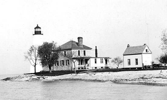
Photo: US Coast Guard, public domain · Wikimedia Commons
Local history sources: twp.jerusalem.oh.us · en.wikipedia.org · en.wikipedia.org · commons.wikimedia.org
Water
Mostly private wells The water here
- Oregon City95% of residentsLake Erie
- Northwestern W and SD - Oregon Wtln 2005% of residentsLake Erie
Hospitals, fire stations and more
Inside Jerusalem Township, Lucas County's boundary: 1 fire or EMS station, 1 high-hazard dam, 2 public schools and 5 spill cases. Press a pin or a name for its whole record and its source.
Fire and EMS stations (1)
-
Jerusalem Township Fire DepartmentCurtice
- Address
- 9501 Jerusalem Road, Curtice, OH 43412
- Coordinates
- 41.63891, -83.32019
USGS National Map structures (source) ↗ Street map and directions ↗
Source: USGS National Map structures (most Ohio records last updated 2019 to 2022), checked against the Columbus and Cleveland station lists. The department that answers a call is set by jurisdiction and mutual aid, not by distance.
High-hazard dams (1)
-
Howard Farm DamWards Canal · condition: satisfactory
- Hazard class
- High: a failure would probably cost a life
- Condition
- Satisfactory (assessed 03/21/2019)
- River or stream
- Wards Canal
- Purpose
- Recreation
- Type
- Earth
- Height
- 18 ft
- Storage
- 3,833 acre-feet
- Completed
- 2018
- Owner type
- Local Government
- County
- Lucas County
- Nearest town (NID)
- Howard Farms Beach
- Last inspection
- 10/02/2024
- Emergency action plan
- Yes
- NID ID
- OH03218
National Inventory of Dams record ↗ National Inventory of Dams (source) ↗ Street map and directions ↗
Source: U.S. Army Corps of Engineers National Inventory of Dams, August 2026. "High hazard" rates what a failure would cost downstream, not how likely one is; the condition is the state's assessment.
Public schools (2)
-
Eisenhower Intermediate School3.5 of 5 stars · Oregon
- Address
- 331 North Curtice Road, Oregon, OH 43616
- School district
- Oregon City School District
- Kind (NCES)
- Regular School
- Students, 2023-24
- 454
- Teachers (full-time equivalent)
- 33
- Report card, 2025-26
- 3.5 of 5 stars
- Performance index
- 80.5%
- Ohio building IRN
- 014259
- NCES school ID
- 390446005802
NCES school record ↗ Ohio School Report Card ↗ Street map and directions ↗
-
Jerusalem Elementary School4 of 5 stars · Curtice
- Address
- 535 S Yondota Rd, Curtice, OH 43412
- School district
- Oregon City School District
- Kind (NCES)
- Regular School
- Students, 2023-24
- 442
- Teachers (full-time equivalent)
- 22
- Report card, 2025-26
- 4 of 5 stars
- Performance index
- 87.1%
- Ohio building IRN
- 018291
- NCES school ID
- 390446001479
NCES school record ↗ Ohio School Report Card ↗ Street map and directions ↗
Source: NCES EDGE public school locations 2024-25 and Common Core of Data 2023-24 (type, students, teachers); Ohio School Report Cards 2025-26 (Department of Education and Workforce), matched by name within the district.
Spills reported since 2021 (5)
-
Sheen Rainbow / Hydrocarbon Reached water2024-08-26 · Jerusalem Twp
- Reported
- 2024-08-26
- What spilled
- Sheen Rainbow / Hydrocarbon
- Reached a waterway
- 99 - Unnamed
- Where
- Jerusalem Twp, Lucas County
- Ohio EPA district office
- NWDO
- Ohio EPA case number
- 2408EPA0001470
Ohio EPA spill reports (source) ↗ Street map and directions ↗
-
Fuel Diesel / Diesel Fuel (Vehicle On Or Off Road)2022-09-13 · Jerusalem Twp
- Reported
- 2022-09-13
- What spilled
- Fuel Diesel / Diesel Fuel (Vehicle On Or Off Road)
- Where
- Jerusalem Twp, Lucas County
- Ohio EPA district office
- NWDO
- Ohio EPA case number
- 2209EPA0001401
Ohio EPA spill reports (source) ↗ Street map and directions ↗
-
Potassium Permanganate (Kmno4)2022-04-28 · Jerusalem Twp
- Reported
- 2022-04-28
- What spilled
- Potassium Permanganate (Kmno4)
- Largest amount reported
- 1,000 gallons
- Where
- Jerusalem Twp, Lucas County
- Ohio EPA district office
- NWDO
- Ohio EPA case number
- 2204EPA0000603
Ohio EPA spill reports (source) ↗ Street map and directions ↗
-
Fuel Diesel / Diesel Fuel (Vehicle On Or Off Road)2021-08-04 · Jerusalem Twp
- Reported
- 2021-08-04
- What spilled
- Fuel Diesel / Diesel Fuel (Vehicle On Or Off Road)
- Where
- Jerusalem Twp, Lucas County
- Ohio EPA district office
- NWDO
- Ohio EPA case number
- 2108EPA0001183
Ohio EPA spill reports (source) ↗ Street map and directions ↗
-
Orphan Drum(S)2021-06-01 · Jerusalem Twp
- Reported
- 2021-06-01
- What spilled
- Orphan Drum(S)
- Where
- Jerusalem Twp, Lucas County
- Ohio EPA district office
- NWDO
- Ohio EPA case number
- 2106EPA0000770
Ohio EPA spill reports (source) ↗ Street map and directions ↗
Source: Ohio EPA emergency response spill reports, 2021 to September 2026, one point per case where Ohio EPA placed it. A report is what the caller or responder recorded; amounts are often blank or estimated.
Its ZIP codes
Each ZIP code that touches Jerusalem Township, Lucas County, with the share of its residents who live here and the same headline figures as the ZIP page.
| ZIP | Share | Water | Radon | Home value | Schools | Flood |
|---|---|---|---|---|---|---|
| 43412 Jerusalem Township and Curtice | 50% | Mostly private wells | 4.7 pCi/L average radon | Median year built 1968 | Oregon City · 3.5 stars overall | 36% of residents in the 1% floodplain |
| 43445 Clay Township and Martin | 16% | Mostly private wells | Too few radon tests | Median year built 1963 | Genoa Area Local · 3.5 stars overall | 15% of residents in the 1% floodplain |
| 43616 Oregon | 3% | Lake Erie, via a submerged intake crib about 1.5 miles offshore and 16 feet deep, connected by a 48-inch line to the Low Pressure Pumping Station near Anchor Point Marina | 4.2 pCi/L average radon | Median year built 1965 | Oregon City · 3.5 stars overall | 4.7% of residents in the 1% floodplain |
Local government
Who holds office in Jerusalem Township, Lucas County, how its elections and ballot issues came out, and the state auditor's record.
Auditor of State record
- No fiscal caution, watch or emergency on the Auditor of State's lists.
- Financial Audit, 2023 to 2024, released 2026-04-14
The county
Lucas County: 26 ZIP codes, 20 cities, villages and townships, 427,372 people.
Nearby places
Quick answers
What county is Jerusalem Township, Ohio in?
Jerusalem Township, Lucas County is a township in Lucas County, Ohio, with 2,895 residents.
When was Jerusalem Township, Ohio founded?
Jerusalem Township, Lucas County was settled Eber Brock Ward's lumber and canal operations from the 1870s; earlier scattered Ottawa and settler habitation; incorporated township organized March 10, 1893. Source
How did Jerusalem Township, Ohio get its name?
The township's own history states it was named for the biblical city of Jerusalem, without further explanation of who chose the name or why; Eber Brock Ward's lumber village on the same ground, active in the 1870s, was named New Jerusalem. Source
What ZIP code is Jerusalem Township, Ohio?
Jerusalem Township, Lucas County is served by ZIP codes 43412, 43445 and 43616; 43412 holds the largest share of its residents.
Where does Jerusalem Township, Ohio get its water?
The main water source for Jerusalem Township, Lucas County (Oregon City): Mostly private wells.
Cite this page
Cite this page as:
Cracked Buckeye, "Jerusalem Township, Lucas County", https://crackedbuckeye.com/place/jerusalem-township-lucas-county/, built 2026-10-31, accessed [date].
How to cite · Report a correction · Built 2026-10-31
