Local events in Franklin Township, Coshocton County
Nothing is posted for Franklin Township itself yet; here is what is on within 10 miles. All local events in Franklin Township, Coshocton County
Know a calendar we should watch? Send the link
Checked October 20; the events page is refreshed daily.
How Franklin Township, Coshocton County began
Franklin Township, organized in September 1814 off the south end of Tuscarawas township, sits in the southern part of Coshocton County along the Muskingum River and contains the village of Conesville in its western section. Its earliest landholders, Major William Robinson and Michael Miller, both Virginians, bought military land sections here in 1800; Robinson had passed through the same ground twenty-six years earlier as a captive of the Mingo chief Logan. French and German Catholic immigrants settled the eastern hills from the 1830s onward. The township's most visible modern landmark, the coal-fired Conesville Power Plant, dates to the mid-20th century, well after the pioneer period.
Settled 1801 (Major William Robinson and Michael Miller), incorporated September 6, 1814, by Coshocton County commissioners Mordecai Chalfant and James Meskimen, erected off the south end of Tuscarawas Township.
Where the name comes from
No township-specific naming account was found; Franklin is a common township name in Ohio (twenty-one townships statewide carry it), generally honoring Benjamin Franklin, but no source, including the 1881 county history, ties Coshocton County's choice to a specific local reason or founder.
Before the town
Franklin Township's clearest documented tie to Native American history is Major William Robinson's captivity. In July 1774, during Dunmore's War, Robinson was captured on the Monongahela by a party of eight Indians led by Logan, the Mingo (Cayuga) chief then avenging the murder of his family at Yellow Creek. Logan saved Robinson from being burned at the stake at a village on the site of Dresden, adopting him with a wampum belt, and the party then took him up the Muskingum through Indian villages to a town at Newcomerstown; along that route he passed through the ground he would purchase and settle twenty-six years later as the southwest military section of Franklin Township. In 1835, when a road was opened east of the river between the Robinson and Miller sections, a burial mound about twenty-five feet across and five feet high was leveled, and the remains of five or six skeletons were found arranged like the spokes of a wheel with heads toward the center; a smaller mound stood, as of 1881, west of the river near the Wolfe-Miller line.
Nations recorded here: Mingo (Seneca-Cayuga).
- Robinson-Miller road burial mound (mound) — on the road opened in 1835 between the Robinson and Miller military sections, Franklin Township, prehistoric (exact culture undetermined) (archive.org)
Timeline
- — Major William Robinson, later a Franklin Township landowner, is captured during Dunmore's War and carried by Logan's party up the Muskingum through the route that later becomes his own farm.
- — The military section that becomes Robinson's farm is granted to William Edgar Jr. by President John Adams and transferred to William Robinson that October.
- — William Robinson's son Benjamin clears the first crop of corn on the family's new land; Michael Miller, of Hampshire County, Virginia, also arrives to settle the adjoining military section.
- — Franklin Township is organized off the south end of Tuscarawas Township on September 6, with the first township election held at John Wamsley's house.
- — A prehistoric burial mound is leveled during road construction between the Robinson and Miller sections, exposing five or six skeletons.
- — Philip Kromnaker becomes the first Frenchman to settle in the township's eastern hills, the start of an Alsatian immigration that predominates there by 1850.
- — Conesville United Methodist Church, a brick structure still standing in the village, is built.
Stories
Logan's captive comes home to the Muskingum
William Robinson was captured on July 12, 1774, while pulling flax on the Monongahela, by a party of eight Indians led by Logan, the Mingo chief then avenging wrongs done his family. Logan called out that he would not be hurt, but Robinson ran anyway and was caught; taken to a village on the site of Dresden, he was tied to the stake to be burned three separate times, and three times Logan's oratory before the council saved him, at last placing a wampum belt on him as a mark of adoption. From there Robinson was marched up the Muskingum through several Indian towns to one at Newcomerstown, where Logan dictated a letter for him to carry, addressed to Colonel Cresap and written in gunpowder ink; that note, later found on a war club after a settler's murder, closely echoes Logan's own well-known speech. Robinson was released after about four months and returned to Virginia, but in 1801, at the age of about fifty-eight, he emigrated with his family to settle permanently on the very stretch of the Muskingum he had passed through as a captive twenty-six years before, in what became Franklin Township.
Photographs
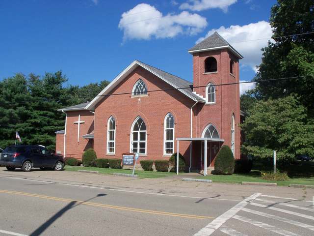
Photo: Roseohioresident, Wikimedia Commons, CC BY-SA 4.0 · Wikimedia Commons
Local history sources: en.wikipedia.org · en.wikipedia.org · commons.wikimedia.org · archive.org
Water
Mostly private wells The water here
- Coshocton99% of residentsSand & gravel aquifer near Walhonding River/Mill Creek valley (wells)
- Bomac Mobile Home Park1% of residentsGroundwater wells (2 wells)
Hospitals, fire stations and more
Inside Franklin Township, Coshocton County's boundary: 1 fire or EMS station, 1 high-hazard dam, 1 Superfund site, 4 Toxics Release Inventory facilities and 5 spill cases. Press a pin or a name for its whole record and its source.
Fire and EMS stations (1)
-
Franklin Conesville Virginia Volunteer Fire DepartmentConesville
- Address
- 15810 Township Road 483C, Conesville, OH 43811
- Coordinates
- 40.18448, -81.89557
USGS National Map structures (source) ↗ Street map and directions ↗
Source: USGS National Map structures (most Ohio records last updated 2019 to 2022), checked against the Columbus and Cleveland station lists. The department that answers a call is set by jurisdiction and mutual aid, not by distance.
High-hazard dams (1)
-
Wills Creek DamWills Creek · condition: not available
- Hazard class
- High: a failure would probably cost a life
- Condition
- Not Available
- River or stream
- Wills Creek
- Purpose
- Flood Risk Reduction;Fish and Wildlife Pond;Recreation
- Type
- Earth
- Height
- 87 ft
- Storage
- 196,000 acre-feet
- Completed
- 1936
- Owner type
- Federal
- County
- Coshocton County
- Nearest town (NID)
- Wills Creek
- Last inspection
- 06/10/2021
- Emergency action plan
- Yes
- NID ID
- OH00002
National Inventory of Dams record ↗ National Inventory of Dams (source) ↗ Street map and directions ↗
Source: U.S. Army Corps of Engineers National Inventory of Dams, August 2026. "High hazard" rates what a failure would cost downstream, not how likely one is; the condition is the state's assessment.
Superfund sites (1)
-
Coshocton LandfillSuperfund program · Franklin Township
- Address
- 19233 Ohio State Route 83, Franklin Township, OH 43812
- County
- Coshocton County
- Status
- Deleted from the National Priorities List (cleanup done)
- EPA program ID
- OHD980509830
- EPA registry ID
- 110071101949
EPA facility record ↗ EPA Facility Registry Service (source) ↗ Street map and directions ↗
Source: EPA Facility Registry Service, Superfund (SEMS) and National Priorities List sites. Many program sites were assessed and needed no cleanup.
Facilities reporting toxic releases (4)
-
American Electric Power Conesville PlantToxics Release Inventory · Conesville
- Address
- 47201 County Road 273, Conesville, OH 43811
- County
- Coshocton County
- Status
- Reports to the Toxics Release Inventory (open)
- EPA program ID
- 43811MRCNL47201
- EPA registry ID
- 110000605417
EPA facility record ↗ EPA Facility Registry Service (source) ↗ Street map and directions ↗
-
Cleveland-Cliffs Steel CorporationToxics Release Inventory · Coshocton
- Address
- 17400 State Route 16, Coshocton, OH 43812
- County
- Coshocton County
- Status
- Reports to the Toxics Release Inventory (open)
- EPA program ID
- 43812CSHCTSTATE
- EPA registry ID
- 110000384673
EPA facility record ↗ EPA Facility Registry Service (source) ↗ Street map and directions ↗
-
Ershigs Conesville Stack LinerToxics Release Inventory · Conesville
- Address
- 47201 County Rd 273, Conesville, OH 43811
- County
- Coshocton County
- Status
- Reports to the Toxics Release Inventory (closed)
- EPA program ID
- 43811RSHGS4721C
- EPA registry ID
- 110039019745
EPA facility record ↗ EPA Facility Registry Service (source) ↗ Street map and directions ↗
-
Three Rivers Energy, LlcToxics Release Inventory · Coshocton
- Address
- 18137 County Road 271, Coshocton, OH 43812
- County
- Coshocton County
- Status
- Reports to the Toxics Release Inventory (active)
- EPA program ID
- 4381WTHRRV18137
- EPA registry ID
- 110032825361
EPA facility record ↗ EPA Facility Registry Service (source) ↗ Street map and directions ↗
Source: EPA Facility Registry Service, Toxics Release Inventory reporters. Reporting a release is required of large users of listed chemicals; it is not by itself a violation.
Spills reported since 2021 (5)
-
Oil Petroleum Not Otherwise Specified (Nos)2025-08-18 · Franklin Twp
- Reported
- 2025-08-18
- What spilled
- Oil Petroleum Not Otherwise Specified (Nos)
- Where
- Franklin Twp, Coshocton County
- Ohio EPA district office
- SEDO
- Ohio EPA case number
- 2508EPA0001399
Ohio EPA spill reports (source) ↗ Street map and directions ↗
-
Fuel Diesel / Diesel Fuel (Vehicle On Or Off Road)2025-03-06 · Franklin Twp
- Reported
- 2025-03-06
- What spilled
- Fuel Diesel / Diesel Fuel (Vehicle On Or Off Road)
- Largest amount reported
- 72 gallons
- Where
- Franklin Twp, Coshocton County
- Ohio EPA district office
- SEDO
- Ohio EPA case number
- 2503EPA0000306
Ohio EPA spill reports (source) ↗ Street map and directions ↗
-
Oil Transformer Non Pcb2024-07-03 · Franklin Twp
- Reported
- 2024-07-03
- What spilled
- Oil Transformer Non Pcb
- Largest amount reported
- 100 gallons
- Where
- Franklin Twp, Coshocton County
- Ohio EPA district office
- SEDO
- Ohio EPA case number
- 2407EPA0001120
Ohio EPA spill reports (source) ↗ Street map and directions ↗
-
Sheen Rainbow / Hydrocarbon Reached water2022-09-03 · Franklin Twp
- Reported
- 2022-09-03
- What spilled
- Sheen Rainbow / Hydrocarbon
- Reached a waterway
- 99 - Unnamed
- Where
- Franklin Twp, Coshocton County
- Ohio EPA district office
- SEDO
- Ohio EPA case number
- 2209EPA0001354
Ohio EPA spill reports (source) ↗ Street map and directions ↗
-
Hydrofluoric Acid (Hf)2022-03-07 · Franklin Twp
- Reported
- 2022-03-07
- What spilled
- Hydrofluoric Acid (Hf)
- Where
- Franklin Twp, Coshocton County
- Ohio EPA district office
- SEDO
- Ohio EPA case number
- 2203EPA0000290
Ohio EPA spill reports (source) ↗ Street map and directions ↗
Source: Ohio EPA emergency response spill reports, 2021 to September 2026, one point per case where Ohio EPA placed it. A report is what the caller or responder recorded; amounts are often blank or estimated.
Its ZIP codes
Each ZIP code that touches Franklin Township, Coshocton County, with the share of its residents who live here and the same headline figures as the ZIP page.
| ZIP | Share | Water | Radon | Home value | Schools | Flood |
|---|---|---|---|---|---|---|
| 43811 Conesville | 17% | Mostly private wells | 6.6 pCi/L average radon | Median year built 1954 | River View Local · 3 stars overall | 1.6% of residents in the 1% floodplain |
| 43812 Coshocton | 4% | Wells in a buried sand-and-gravel valley aquifer just off State Route 83 N, near where Mill Creek meets the Walhonding River north of downtown Coshocton | 9.4 pCi/L average radon | Median year built 1950 | Coshocton City · 3.5 stars overall | 4.3% of residents in the 1% floodplain |
Local government
Who holds office in Franklin Township, Coshocton County, how its elections and ballot issues came out, and the state auditor's record.
Money issues on the ballot since 2019: 2 of 2 passed.
Ballot issues
| Date | Issue | For | Against | Result |
|---|---|---|---|---|
| 2019-11-05 | Issue 3: Franklin Township Fire (levy type not on the results report) | 299 | 128 | Passed (70.02% for) |
| 2019-11-05 | Issue 4: Franklin Township Garbage (levy type not on the results report) | 268 | 148 | Passed (64.42% for) |
Elections for office
| Date | Office | Candidates and votes |
|---|---|---|
| 2019-11-05 | Township Trustee | Larry G. Boal 160, 38.1%; Greg Cox Jr. 133, 31.67%; Ed Elliott 127, 30.24% |
| 2019-11-05 | Township Fiscal Officer | Heather Cox 175, 42.89%; Cindy McVey 233, 57.11% |
Winners in bold. Results from the county board of elections' official canvass unless marked.
The county
Coshocton County: 8 ZIP codes, 25 cities, villages and townships, 33,626 people.
Nearby places
Quick answers
What county is Franklin Township, Ohio in?
Franklin Township, Coshocton County is a township in Coshocton County, Ohio, with 837 residents.
When was Franklin Township, Ohio founded?
Franklin Township, Coshocton County was settled 1801 (Major William Robinson and Michael Miller); incorporated September 6, 1814. Founders on record: Coshocton County commissioners Mordecai Chalfant and James Meskimen, erected off the south end of Tuscarawas Township. Source
How did Franklin Township, Ohio get its name?
No township-specific naming account was found; Franklin is a common township name in Ohio (twenty-one townships statewide carry it), generally honoring Benjamin Franklin, but no source, including the 1881 county history, ties Coshocton County's choice to a specific local reason or founder. Source
What ZIP code is Franklin Township, Ohio?
Franklin Township, Coshocton County is served by ZIP codes 43811 and 43812; 43811 holds the largest share of its residents.
Where does Franklin Township, Ohio get its water?
The main water source for Franklin Township, Coshocton County (Coshocton): Mostly private wells.
Cite this page
Cite this page as:
Cracked Buckeye, "Franklin Township, Coshocton County", https://crackedbuckeye.com/place/franklin-township-coshocton-county/, built 2026-10-31, accessed [date].
How to cite · Report a correction · Built 2026-10-31
