Local events in Conesville
Nothing is posted for Conesville itself yet; here is what is on within 10 miles. All local events in Conesville
Know a calendar we should watch? Send the link
Checked October 20; the events page is refreshed daily.
Lakes near Conesville
The history under the water: the valley before, the dam, the stories. All Ohio lakes
Videos about Conesville
Short videos we made from the old maps and records. All videos
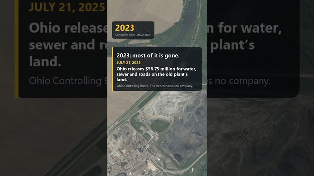
How Conesville began
Conesville sits on the Muskingum River in western Franklin Township. A settlement here was first attempted before 1840 by a man named Delaney, who planned a town called Delaneysville that never incorporated; the place instead took shape and its lasting name from Beebe Stewart Cone, who with three partners built a large distillery on the river's west bank in 1847. For over sixty years, from 1957 until 2020, the village's economy and identity were dominated by the coal-fired Conesville Power Plant just outside town; the plant was demolished in 2021 and its population, 328 at the 2020 census, has been declining for decades.
Platted 1847, by Beebe Stewart Cone and three partners.
Where the name comes from
Most likely named for Beebe Stewart Cone, who in 1847 built a distillery here with three other men; an earlier, failed attempt to found a town on the same ground before 1840, by a man named Delaney, would have been called Delaneysville.
Before the town
No Native village or site at Conesville itself is recorded in the sources checked. The 1881 county history reports that about 1835, when the road between the Robinson and Miller sections was cut east of the Muskingum in Franklin Township, a mound about twenty-five feet across and five feet high lay in the road and was leveled; it held the remains of five or six skeletons laid out like the spokes of a circle with the heads at the center, and a small mound still stood west of the river. These are township notes, not placed at the village. The village lies on the Muskingum a few miles below the forks at Coshocton, the historic Lenape (Delaware) center of the region.
Timeline
- — Before this year, a man named Delaney buys land on the site intending to found a town called Delaneysville; it never incorporates.
- — Beebe Stewart Cone and three partners build a large distillery on the west side of the Muskingum River, with worker housing and small businesses growing up nearby.
- — The distillery burns; Cone leaves for Iowa. James Beebe rebuilds it, but the rebuilt distillery also later burns down.
- — The Bethel Methodist Episcopal church west of the Muskingum is organized at the Conesville schoolhouse by the ministers of the Dresden and Roscoe circuits.
- — The 1881 county history calls Conesville 'merely a railroad station, with a country store attached'; the sixteen or eighteen houses and the cooper shop that had grown up around Cone's distillery have all been removed.
- — David Davis, a former miner, buys out his partners and builds the Davis coal mine near Conesville, selling to the Pennsylvania Lines.
- — G. W. Cassingham opens a mine on the McCleary and Vance land in Franklin Township, shipping over the Wheeling and Lake Erie to Canton and Cleveland.
- — The Oden Valley Coal Company opens mines northwest of Conesville, connecting with the Panhandle railroad over part of the Davis track.
- — Where David Davis began mining there were not more than three houses; Conesville is now a village of about four hundred whose wage-earners are mine workers.
- — The census counts 466 residents, the highest figure on record.
- — The Conesville Power Plant begins operations just east of the village.
- — The Conesville Power Plant ceases generation in April.
- — Conesville has 328 residents.
- — The former power plant is demolished.
Stories
A distillery, two fires, and a name
Before 1840 a man named Delaney tried to found a town on the west bank of the Muskingum here and meant to call it Delaneysville, but the plan never took hold as an incorporated place. It was Beebe Stewart Cone who actually built something lasting: in 1847 he and three partners put up a sizable distillery, and workers' houses and a handful of small businesses grew up around it. The distillery burned in 1857, and Cone left for Iowa. James Beebe rebuilt it, but that building burned too, a few years later, ending the village's distilling era for good -- though Cone's name stayed on the map.
Sixty-three years under the power plant's shadow
The Conesville Power Plant, a coal-fired station with a nameplate capacity of over 2,000 megawatts, started generating in 1957 just outside the village and became the backbone of Conesville's economy for more than six decades. When American Electric Power shut the plant down in April 2020 and it was torn down the following year, Conesville, Franklin Township, and the River View Local Schools all lost a major share of their tax base, forcing staff cuts and a reconfiguration of the school district -- a story repeated in coal communities across the country as plants like it closed.
From three houses to four hundred
When David Davis, who had worked as a miner with a pick, bought out his partners in 1885 and opened a mine of his own near Conesville, he told his wife that the hills were full of coal and that some day he would own them. By 1909 the hamlet around his workings, which had held not more than three houses, had become a village of about four hundred, nearly all mine workers. The Davis mine sold to the Pennsylvania Lines; the Oden Valley company opened mines to the northwest in 1894 and used part of the Davis track to reach the Panhandle railroad; the Arnold and Burt companies opened mines along the Wheeling and Lake Erie to the southeast, later owned by the Barnes Coal Company. A large sum was paid out monthly in wages. The earlier Conesville, the distillery village of the 1850s, had vanished by 1881, so the mining town was in effect a second founding.
Photographs
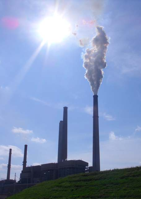
Photo: Ibagli, public domain · Wikimedia Commons
Local history sources: en.wikipedia.org · en.wikipedia.org · en.wikipedia.org · commons.wikimedia.org · archive.org · archive.org
Water
No water-system data is linked to Conesville's ZIP codes yet.
Its ZIP codes
Each ZIP code that touches Conesville, with the share of its residents who live here and the same headline figures as the ZIP page.
| ZIP | Share | Water | Radon | Home value | Schools | Flood |
|---|---|---|---|---|---|---|
| 43811 Conesville | 43% | Mostly private wells | 6.6 pCi/L average radon | Median year built 1954 | River View Local · 3 stars overall | 1.6% of residents in the 1% floodplain |
Local government
Who holds office in Conesville, how its elections and ballot issues came out, and the state auditor's record.
Elections for office
| Date | Office | Candidates and votes |
|---|---|---|
| 2019-11-05 | Member of Council | Annette M. Kimberley 65, 46.76%; Jennifer McFarland 74, 53.24% |
| 2019-11-05 | Mayor | Marge Donley 78, 100.0% |
| 2019-11-05 | Clerk | Cory Humphreys 81, 100.0% |
Winners in bold. Results from the county board of elections' official canvass unless marked.
Auditor of State record
- No fiscal caution, watch or emergency on the Auditor of State's lists.
- Basic Audit, 2023 to 2024, released 2025-05-08
The county
Coshocton County: 8 ZIP codes, 25 cities, villages and townships, 33,626 people.
Nearby places
Rain and snow
How much has actually fallen on Conesville, day by day, from 1887 to now. Daily totals, not averages.
- rain, last 30 days
- 1.16 in
- 2026-09-30 to 2026-10-29
- rain so far in 2026
- 44.5 in
- 7.8 in above normal for the date
- snow so far in 2026
- 23.1 in
- a normal year brings 23.1 in
- a normal year
- 43.1 in
- average of 30 years, 1991-2020
| Month | Rain (in) | Snow (in) | Days counted |
|---|---|---|---|
| October 2026 | 1.16 | — | 29 |
| September 2026 | 5.53 | — | 30 |
| August 2026 | 9.50 | — | 31 |
| July 2026 | 4.12 | — | 31 |
| June 2026 | 4.11 | — | 30 |
| May 2026 | 6.67 | — | 31 |
| April 2026 | 3.30 | — | 30 |
| March 2026 | 6.64 | 2.5 | 31 |
| February 2026 | 1.53 | 3.2 | 28 |
| January 2026 | 1.98 | 17.4 | 31 |
| December 2025 | 2.72 | 11.2 | 31 |
| November 2025 | 2.38 | 0.2 | 30 |
| Wettest year | 2004 — 57.7 in |
|---|---|
| Driest year | 1930 — 23.6 in |
| Snowiest year | 1910 — 59.1 in |
| Wettest day on record | 7 August 1935 — 6.58 in |
| Heaviest snowfall in a day | 20 April 1901 — 13.26 in |
| Deepest snow on the ground | 15 January 1968 — 20.67 in |
Estimated, not measured. No rain gauge has ever stood inside Conesville, so every figure here is worked out from the gauges around it - the nearest ones weighted most. Treat them as close estimates rather than readings.
49,711 days of records, 1887-08-01 to 2026-10-29. Source: NOAA NCEI GHCN-Daily, 3,240 gauges in and around Ohio. A day is "gauged" when a gauge standing inside the boundary reported it, and the value is the mean of those gauges. Otherwise it is interpolated by inverse distance from every gauge reporting within 50 miles. Nothing is carried forward, back-filled or smoothed. Against NOAA nClimDiv county monthly precipitation over 136,848 complete county-months (checked 2026-10-31): correlation 0.9515, median absolute difference 0.217 in a month. Built 2026-10-31 from the Cracked Buckeye precipitation archive. Snow is the softer number — snowfall is measured by hand with a ruler, no agency publishes a gridded county snowfall series, and blowing snow defeats every observer.
Environmental permits and filings
What Ohio EPA has on file for Conesville: permits, inspections, violations, cleanups and the state loans behind sewer and water work. Every line links to the agency's own document.
- facilities and sites on file
- 2
- those placed on the map inside Conesville
| Program | Facilities and sites |
|---|---|
| Public drinking water | 2 |
| Date | Facility or site | What |
|---|---|---|
| CONESVILLE UNITED METHODIST CHURCH PWS | Public drinking water violation resolved | |
| CONESVILLE UNITED METHODIST CHURCH PWS | Public drinking water inspection | |
| CONESVILLE UNITED METHODIST CHURCH PWS | Public drinking water notice of violation | |
| CONESVILLE UNITED METHODIST CHURCH PWS | Public drinking water violation resolved | |
| CONESVILLE UNITED METHODIST CHURCH PWS | Public drinking water report | |
| CONESVILLE UNITED METHODIST CHURCH PWS | Public drinking water inspection | |
| CONESVILLE ELEMENTARY SCHOOL PWS | Public drinking water inspection | |
| CONESVILLE ELEMENTARY SCHOOL PWS | Public drinking water inspection | |
| CONESVILLE ELEMENTARY SCHOOL PWS | Public drinking water violation resolved | |
| CONESVILLE ELEMENTARY SCHOOL PWS | Public drinking water notice of violation | |
| CONESVILLE ELEMENTARY SCHOOL PWS | Public drinking water plan | |
| CONESVILLE ELEMENTARY SCHOOL PWS | Public drinking water compliance letter | |
| CONESVILLE ELEMENTARY SCHOOL PWS | Public drinking water inspection | |
| CONESVILLE ELEMENTARY SCHOOL | Public drinking water monitoring results | |
| CONESVILLE UNITED METHODIST CHURCH PWS | Public drinking water inspection | |
| CONESVILLE ELEMENTARY SCHOOL | Public drinking water inspection | |
| CONESVILLE ELEMENTARY SCHOOL | Public drinking water compliance letter | |
| CONESVILLE ELEMENTARY SCHOOL | Public drinking water inspection | |
| CONESVILLE ELEMENTARY SCHOOL | Public drinking water inspection | |
| CONESVILLE ELEMENTARY SCHOOL | Public drinking water report | |
| CONESVILLE ELEMENTARY SCHOOL | Public drinking water plan | |
| CONESVILLE ELEMENTARY SCHOOL | Public drinking water report |
Source: Ohio EPA eDocument portal (edocpub.epa.ohio.gov), indexed 2026-10-14. Facilities are placed on the map from Ohio EPA's own map layers, EPA's Facility Registry, coordinates written in the filings, or a geocoded street address. A permit filed under a private person's name (most are household septic systems) is counted but never named, placed or linked; licenses for individual workers and open-burning notices are left out entirely.
Quick answers
What county is Conesville, Ohio in?
Conesville is a village in Coshocton County, Ohio, with 328 residents.
When was Conesville, Ohio founded?
Conesville was laid out 1847. Founders on record: Beebe Stewart Cone and three partners. Source
How did Conesville, Ohio get its name?
Most likely named for Beebe Stewart Cone, who in 1847 built a distillery here with three other men; an earlier, failed attempt to found a town on the same ground before 1840, by a man named Delaney, would have been called Delaneysville. Source
What ZIP code is Conesville, Ohio?
Most of Conesville is in ZIP code 43811.
Where does Conesville, Ohio get its water?
The main water source for Conesville: Mostly private wells.
Cite this page
Cite this page as:
Cracked Buckeye, "Conesville, Coshocton County", https://crackedbuckeye.com/place/conesville/, built 2026-10-31, accessed [date].
How to cite · Report a correction · Built 2026-10-31
