Local events in Clark Township, Coshocton County
Nothing is posted for Clark Township itself yet; here is what is on within 10 miles. All local events in Clark Township, Coshocton County
Know a calendar we should watch? Send the link
Checked October 20; the events page is refreshed daily.
Deep dives about Clark Township, Coshocton County
Long reads built from maps, newspapers and public records. All deep dives
How Clark Township, Coshocton County began
Clark Township, in the northern part of Coshocton County on the Holmes County line, was part of Mechanic Township until it was organized in 1829 at the house of Peter Buckmaster and named for Samuel Clark, a county commissioner. Settlement began about 1815 along the Killbuck and Doughty's Fork; Eli Fox's mills at what became Helmick (1820) and William Craig's cabin at Bloomfield (1819) anchored the township, which has never had an incorporated village. Its population grew from 246 in 1830 to 1,012 in 1880. Blissfield, on the railroad, was laid out in 1890 and gives the township its ZIP code. The Helmick Covered Bridge was added to the National Register in 1975, and the township had 670 residents in 2020.
Settled c.1815-1818, incorporated 1829 (township organized), by Isaac Hoagland, probably the first permanent settler; the Craig family at Bloomfield; Eli Fox at Helmick.
Where the name comes from
Named for Samuel Clark, a county commissioner, 'among the earliest and most highly esteemed citizens of the Killbuck valley,' a resident of neighboring Bethlehem Township.
Before the town
The 1881 county history says no Indian village is known to have stood in Clark Township, but that hunting parties often camped on the Killbuck and on Doughty's Fork. A three-sided hut of split logs, with the open fourth side closed at night by a log fire to keep off animals, stood in a bend on the north side of the Killbuck in the northeast quarter of section 17. The township's streams carry Native names: the Killbuck is said to keep the name of a famous Indian chief, and Doughty's Fork that of a brave called Captain Doughty, who was also known to settlers on Will's Creek and in Virginia Township. A man the settlers called Tom Lyon camped on the Killbuck with other Native men until about 1825, when he left to go west; the settlers reported that he boasted of having taken ninety-nine scalps. The source does not name the nation of any of these people. The wider county context is Lenape (Delaware) and Wyandot.
- Split-log Indian hunting camp on the Killbuck (camp) — Bend on the north side of the Killbuck, northeast quarter of section 17, Clark Township, before about 1825, as remembered in 1881 (archive.org)
Timeline
- — President John Adams grants the township's northeast quarter, 4,000 acres, to Jonathan Burrell of New York; Burrell sells it in 1807 to Philip Itskin of Baltimore, who sells it in parcels.
- — Silas Bent Jr. surveys the southern half of the township as congress land; the western military section is surveyed into forty 100-acre lots by William Cutbush in 1808.
- — Settlement begins about this year; Isaac Hoagland, who came to Coshocton in 1800 with Charles Williams and lived in the first house built there, is probably the first permanent settler, on the southwest quarter of section 16.
- — William Craig builds a cabin where Bloomfield later grows up; his father John Craig, who settled on the first military section in 1818, serves as justice of the peace for Mechanic Township from 1819 to 1822.
- — Eli Fox, a ship-carpenter and miller from Zanesville, builds a sawmill and then a grist-mill about a quarter mile above Helmick; his family follows in 1821, and the mill burns in 1829.
- — Tom Lyon, a Native man who had long camped on the Killbuck, leaves the area for the west.
- — Clark Township is organized as a civil township of Coshocton County, named for county commissioner Samuel Clark.
- — At the first election, held at the house of Peter Buckmaster, only fifteen or twenty votes are cast; Benjamin Patterson is chosen clerk and William Craig justice of the peace.
- — The township's population is 246.
- — The Clark Township Regular Baptist Church is organized by T. G. Jones and E. Otis with eleven members; the Clark Presbyterian Church follows on March 22, 1834, with twelve members, and builds its first church in 1837 for about $200.
- — The township's population is 833, after 703 in 1840.
- — A cheese factory is started at Bloomfield by George Craig, William Renfrew, Solomon Snyder and Robert Graham.
- — The Bloomfield Methodist Episcopal Church, built in the summer of 1871 for about $2,500, is dedicated.
- — The township's population is 1,012 (867 in 1870); Bloomfield, on the Holmes County line, has 28 dwellings, two or three stores, two steam sawmills and three blacksmith shops, and its post office is still called Clark's.
- — Blissfield is laid out when the railroad is extended to that point; its post office, opened in 1889, runs until 2002.
- — Helmick Covered Bridge, within the township, is added to the National Register of Historic Places (reference 75001348, June 18).
- — The census counts 670 people in Clark Township.
Stories
Eli Fox's mills and the Helmick post office
Eli Fox was a Connecticut-born ship-carpenter who had learned milling at Zanesville and had won the contract for the first bridge over the Scioto at Chillicothe before he went looking for a quieter place to build a mill. In 1820 he came to Clark Township with three helpers, among them the blacksmith Piatt Williamson, and raised a sawmill and a grist-mill about a quarter mile above the spot now called Helmick; he moved his family out from Zanesville the next year. The mill burned in 1829, and Fox rebuilt both mills a little farther downstream at Helmick, where Benjamin Beck ran them in 1881. The community's post office was named for William Helmick of Tuscarawas County, who then represented the district in Congress and got the office for it, and Absalom Petit was its first postmaster. The 1881 historian remarked that the mill, post office and store did a much larger business than their appearance would suggest.
A bear in the hollow oak
Deer, bears and wolves were plentiful when the first settlers reached Clark Township, and the 1881 county history preserves the story of Bill and Tom McNeal, sons of the Irish settler Archibald McNeal, who tracked a bear to a tall hollow oak stub. Bill climbed a hickory beside it, crossed over to sit astride the stub, and fired his musket down into the hollow while Tom waited below with the other gun. The shot hit, but only angered the bear, which came up the tree after him; Bill barely had time to drop the gun and swing himself away onto a hickory branch. The bear came down and ran, and Tom wounded it as it fled. The two followed it for about a mile and found it behind a log, packing its wounds with hair, and this time both fired together and killed it.
Photographs
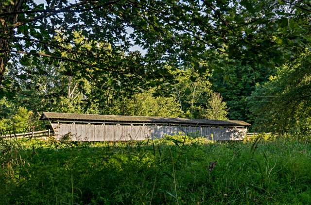
Photo: Mikeatnip, Wiki Loves Monuments 2016, CC BY-SA 4.0 · Wikimedia Commons
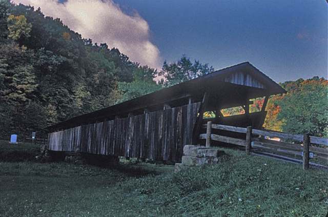
Photo: Jerrye and Roy Klotz, MD, CC BY-SA 4.0 · Wikimedia Commons
Local history sources: en.wikipedia.org · en.wikipedia.org · commons.wikimedia.org · commons.wikimedia.org · archive.org · en.wikipedia.org · en.wikipedia.org
Historic places
1 place in Clark Township, Coshocton County on the National Register of Historic Places. Press a pin or a name for its whole record.
-
Helmick Covered BridgeStructure · Blissfield · listed 1975
- Address
- E of Blissfield on Twnshp. Rd. 25
- Where
- Blissfield, Coshocton County · ZIP 43812
- What it is
- Structure
- Listed on the National Register
- 1975
- NRIS reference number
- 75001348
- Coordinates
- 40.39312, -81.94270
National Register file (NPS) ↗ Search Wikipedia ↗ Street map and directions ↗ On the Cracked Buckeye map
Source: National Park Service, National Register of Historic Places point file. The listing year is shown where NPS's certification date agrees with the listing's reference number. Listing recognizes significance; it does not restrict a private owner.
Water
Mostly private wells The water here
- Coshocton72% of residentsSand & gravel aquifer near Walhonding River/Mill Creek valley (wells)
- Killbuck Village15% of residentsGroundwater wells (2 wells)
- Warsaw13% of residentsGroundwater wells (2 wells)
- Bomac Mobile Home Park1% of residentsGroundwater wells (2 wells)
Hospitals, fire stations and more
Inside Clark Township, Coshocton County's boundary: 1 poor-rated bridge and 1 shale or injection well. Press a pin or a name for its whole record and its source.
Bridges rated poor (1)
-
Township Road 25 over Killbuck CreekPoor · built 1863
- Condition
- Poor: a deck, superstructure, substructure or culvert rated 4 or below on the 0 to 9 scale
- What it is
- Bridge
- Built
- 1863
- Length
- 52 ft
- Owner
- County
- Vehicles a day
- 564
- Coordinates
- 40.39303, -81.94287
National Bridge Inventory (source) ↗ Street map and directions ↗
Source: FHWA National Bridge Inventory 2025. "Poor" means one major part rated 4 or below on the 0 to 9 scale; it calls for repair, not closing, unless the state posts or closes the bridge.
Shale and injection wells (1)
-
E. M. Waters {Erp#7} 6 InjectionInjection well (Class II)
- What it is
- Injection well (Class II)
- Operator
- A Miller Oil Company
- County
- Coshocton County
- API well number
- 34031216650000
- Coordinates
- 40.39592, -81.97245
ODNR oil and gas wells (source) ↗ Street map and directions ↗
Source: ODNR Division of Oil and Gas Resources well inventory (September 2026): drilled Utica, Marcellus and horizontal wells and Class II injection wells not plugged. Older vertical wells are on the full map.
Its ZIP codes
Each ZIP code that touches Clark Township, Coshocton County, with the share of its residents who live here and the same headline figures as the ZIP page.
| ZIP | Share | Water | Radon | Home value | Schools | Flood |
|---|---|---|---|---|---|---|
| 43805 Clark Township and Blissfield | 100% | Mostly private wells | Too few radon tests | Median year built 1900 | River View Local · 3 stars overall | 14% of residents in the 1% floodplain |
| 43844 Jefferson Township and Warsaw | 6% | Mostly private wells | 16.6 pCi/L average radon | Median year built 1979 | River View Local · 3 stars overall | 6.7% of residents in the 1% floodplain |
| 44637 Killbuck Township and Killbuck | 4% | Mostly private wells | 17.9 pCi/L average radon | Median year built 1974 | West Holmes Local · 3.5 stars overall | 15% of residents in the 1% floodplain |
| 43812 Coshocton | 1% | Wells in a buried sand-and-gravel valley aquifer just off State Route 83 N, near where Mill Creek meets the Walhonding River north of downtown Coshocton | 9.4 pCi/L average radon | Median year built 1950 | Coshocton City · 3.5 stars overall | 4.3% of residents in the 1% floodplain |
Local government
Who holds office in Clark Township, Coshocton County, how its elections and ballot issues came out, and the state auditor's record.
Elections for office
| Date | Office | Candidates and votes |
|---|---|---|
| 2019-11-05 | Township Trustee | Benny Patterson 79, 100.0% |
| 2019-11-05 | Township Fiscal Officer | Kevin E. Lowe 92, 100.0% |
Winners in bold. Results from the county board of elections' official canvass unless marked.
The county
Coshocton County: 8 ZIP codes, 25 cities, villages and townships, 33,626 people.
Nearby places
Quick answers
What county is Clark Township, Ohio in?
Clark Township, Coshocton County is a township in Coshocton County, Ohio, with 670 residents.
When was Clark Township, Ohio founded?
Clark Township, Coshocton County was settled c.1815-1818; incorporated 1829 (township organized). Founders on record: Isaac Hoagland, probably the first permanent settler; the Craig family at Bloomfield; Eli Fox at Helmick. Source
How did Clark Township, Ohio get its name?
Named for Samuel Clark, a county commissioner, 'among the earliest and most highly esteemed citizens of the Killbuck valley,' a resident of neighboring Bethlehem Township. Source
What ZIP code is Clark Township, Ohio?
Clark Township, Coshocton County is served by ZIP codes 43805, 43844 and 44637; 43805 holds the largest share of its residents.
Where does Clark Township, Ohio get its water?
The main water source for Clark Township, Coshocton County (Coshocton): Mostly private wells.
Cite this page
Cite this page as:
Cracked Buckeye, "Clark Township, Coshocton County", https://crackedbuckeye.com/place/clark-township-coshocton-county/, built 2026-10-31, accessed [date].
How to cite · Report a correction · Built 2026-10-31
