Local events in Chester Township, Clinton County
Nothing is posted for Chester Township itself yet; here is what is on within 20 miles. All local events in Chester Township, Clinton County
Know a calendar we should watch? Send the link
Checked October 20; the events page is refreshed daily.
Lakes near Chester Township, Clinton County
The history under the water: the valley before, the dam, the stories. All Ohio lakes
Videos about Chester Township, Clinton County
Short videos we made from the old maps and records. All videos
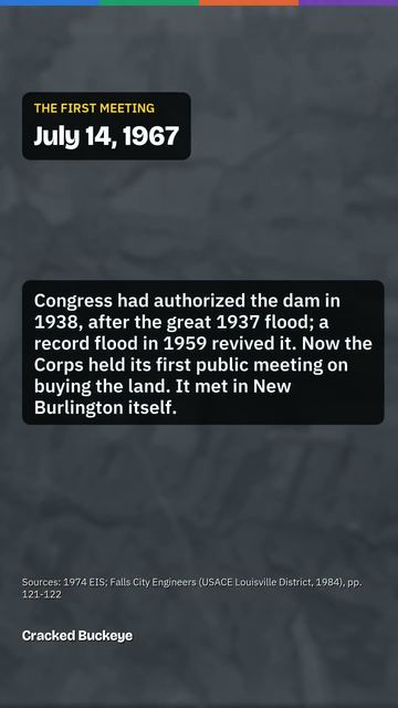
How Chester Township, Clinton County began
Chester Township occupies the northwest corner of Clinton County, Ohio, one of thirteen townships formed after the county's organization in 1810. It is rural and thinly populated (2,027 residents at the 2020 census across 31.9 square miles), with no incorporated village of its own. Its best-known place, New Burlington, was founded in 1833 by settlers from Burlington, North Carolina and survived as a farm town and Underground Railroad station until the U.S. Army Corps of Engineers flooded it in the 1970s to build Caesar Creek Lake, a story told in John Baskin's 1976 book. The township's other notable historic property, the Underwood Farms Rural Historic District along State Route 73 and Brimstone Road, preserves a cluster of nineteenth-century farms and Jonahs Run Baptist Church. Four National Register buildings sometimes associated with the area in shared-ZIP data actually stand across the county line in Warren County and are excluded here.
Incorporated 1810 (as one of Clinton County's original townships, following the county's organization Feb. 19, 1810, effective March 1, 1810).
Where the name comes from
No source we found states why Chester Township was named 'Chester.' Ohio has five townships of that name statewide, a common pattern for townships named after Chester, Pennsylvania or Chester, England by early settlers, but no Clinton County-specific naming record was found.
Before the town
No site-specific Native American history for Chester Township itself was found in the sources consulted (Wikipedia, Ohio History Central's county overview, and the 1880s Duy/Harlan county history). Clinton County was carved from parts of Highland and Warren counties in 1810, both of which lay within the area ceded by the Wyandot, Shawnee, Lenape (Delaware), Ottawa, Miami, and other nations at the 1795 Treaty of Greenville. The Greenville Treaty line itself, however, ran well north of Clinton County: from Fort Recovery east-southeast to near Fort Loramie (Shelby County) and on toward Fort Laurens, and did not pass through Chester Township or Clinton County's borders based on the route described in the Treaty of Greenville article. That places all of Chester Township inside the 1795 cession, not on the boundary line. No mounds, villages, trails, or documented encounters specific to Chester Township turned up.
Timeline
- — Clinton County is organized from parts of Highland and Warren counties, and Chester Township is established as one of its original townships.
- — New Burlington is founded within Chester Township by settlers who named it for Burlington, North Carolina, their former home.
- — A post office opens at New Burlington.
- — Congress authorizes the Caesar Creek Lake flood-control project under the Flood Control Act of 1938, decades before it would reach New Burlington.
- — The New Burlington post office closes as the U.S. Army Corps of Engineers begins acquiring the village for the Caesar Creek Lake reservoir project.
- — The Caesar Creek dam is constructed; New Burlington, in Chester Township, is submerged and its residents relocated.
- — The Underwood Farms Rural Historic District, in the vicinity of State Route 73 and Brimstone Road in Chester Township, is listed on the National Register of Historic Places (reference #05001519).
Stories
The drowning of New Burlington
New Burlington was platted in 1833 by families who had come north from Burlington, North Carolina, and it grew into a modest farm town in the northwest corner of Chester Township, with a post office from 1837. In the years before the Civil War the village is remembered as a stop on the Underground Railroad, part of the network of safe houses that moved people escaping slavery north through Ohio. The town survived more than a century as an ordinary rural crossroads. Then, under a flood-control project authorized by Congress in 1938 and finally built in the 1970s, the U.S. Army Corps of Engineers dammed Caesar Creek and began buying out New Burlington's homes, farms, and church grounds. The post office closed in 1971; by 1978 the dam was complete and the village site lay under the new Caesar Creek Lake. Writer John Baskin spent two years interviewing the town's last residents before the water rose, publishing their voices in the 1976 book 'New Burlington: The Life and Death of an American Village,' now considered a classic account of a rural Ohio community's end. Lawrence E. Mitchner is remembered as the last resident to leave. The New Burlington Cemetery survives above the waterline, one of the few physical traces of the village left in Chester Township.
Photographs
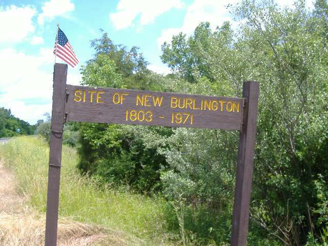
Photo: Aesopposea, via Wikimedia Commons, CC BY-SA 3.0 · Wikimedia Commons
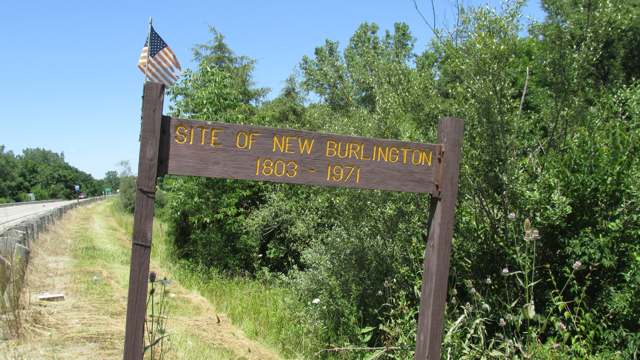
Photo: Aesopposea, via Wikimedia Commons, CC BY-SA 3.0 · Wikimedia Commons
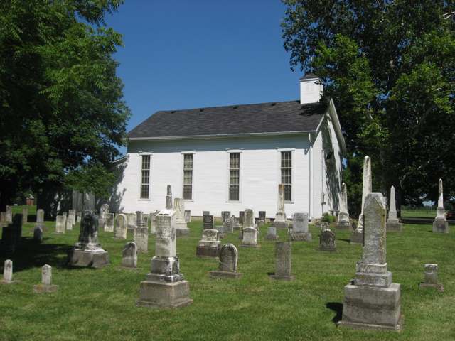
Photo: Nyttend, via Wikimedia Commons, public domain · Wikimedia Commons
Local history sources: en.wikipedia.org · en.wikipedia.org · en.wikipedia.org · en.wikipedia.org · en.wikipedia.org · en.wikipedia.org · en.wikipedia.org · en.wikipedia.org · en.wikipedia.org · archive.org · remarkableohio.org · commons.wikimedia.org · commons.wikimedia.org · commons.wikimedia.org
Water
Caesar Creek Lake (about 14 miles northwest of Wilmington) is a source, treated at a surface-water lime-softening plant. Two reservoirs near Burtonville, about 3 miles south of Wilmington, are kept as an alternative source and can be filled from Cowan Creek OR Caesar Creek Lake; often used when Caesar Creek Lake water is poor quality. There is also an auxiliary connection to Western Water Company for outlying customers during main-break repairs. The water here
- Wilmington City76% of residentsCaesar Creek Lake (with Burtonville reservoirs/Cowan Creek as backup)
- Western Water Company24% of residentsLittle Miami River valley wells (51%) plus Cincinnati Ohio River water (49%)
Hospitals, fire stations and more
Inside Chester Township, Clinton County's boundary: 2 fire and EMS stations and 5 spill cases. Press a pin or a name for its whole record and its source.
Fire and EMS stations (2)
-
Chester Township New Burlington Fire and Rescue Station 1Wilmington
- Address
- 51 Mound Road, Wilmington, OH 45177
- Coordinates
- 39.55532, -83.96463
USGS National Map structures (source) ↗ Street map and directions ↗
-
Chester Township New Burlington Fire and Rescue Station 2Wilmington
- Address
- 5606 State Highway 380, Wilmington, OH 45177
- Coordinates
- 39.51043, -83.94185
USGS National Map structures (source) ↗ Street map and directions ↗
Source: USGS National Map structures (most Ohio records last updated 2019 to 2022), checked against the Columbus and Cleveland station lists. The department that answers a call is set by jurisdiction and mutual aid, not by distance.
Spills reported since 2021 (5)
-
Fuel Diesel / Diesel Fuel (Vehicle On Or Off Road)2025-06-26 · Chester Twp
- Reported
- 2025-06-26
- What spilled
- Fuel Diesel / Diesel Fuel (Vehicle On Or Off Road)
- Largest amount reported
- 300 gallons
- Where
- Chester Twp, Clinton County
- Ohio EPA district office
- SWDO
- Ohio EPA case number
- 2506EPA0001062
Ohio EPA spill reports (source) ↗ Street map and directions ↗
-
Fuel Diesel / Diesel Fuel (Vehicle On Or Off Road) Reached water2023-07-28 · Chester Twp
- Reported
- 2023-07-28
- What spilled
- Fuel Diesel / Diesel Fuel (Vehicle On Or Off Road)
- Largest amount reported
- 150 gallons
- Reached a waterway
- 14 - Dutch Creek
- Where
- Chester Twp, Clinton County
- Ohio EPA district office
- SWDO
- Ohio EPA case number
- 2307EPA0001287
Ohio EPA spill reports (source) ↗ Street map and directions ↗
-
Fuel Diesel / Diesel Fuel (Vehicle On Or Off Road)2021-08-08 · Chester Twp
- Reported
- 2021-08-08
- What spilled
- Fuel Diesel / Diesel Fuel (Vehicle On Or Off Road)
- Largest amount reported
- 40 gallons
- Where
- Chester Twp, Clinton County
- Ohio EPA district office
- SWDO
- Ohio EPA case number
- 2108EPA0001206
Ohio EPA spill reports (source) ↗ Street map and directions ↗
-
Fuel Diesel / Diesel Fuel (Vehicle On Or Off Road)2021-06-09 · Chester Twp
- Reported
- 2021-06-09
- What spilled
- Fuel Diesel / Diesel Fuel (Vehicle On Or Off Road)
- Largest amount reported
- 90 gallons
- Where
- Chester Twp, Clinton County
- Ohio EPA district office
- SWDO
- Ohio EPA case number
- 2106EPA0000820
Ohio EPA spill reports (source) ↗ Street map and directions ↗
-
Fuel Diesel / Diesel Fuel (Vehicle On Or Off Road)2026-07-06 · Chester Twp
- Reported
- 2026-07-06
- What spilled
- Fuel Diesel / Diesel Fuel (Vehicle On Or Off Road)
- Where
- Chester Twp, Clinton County
- Ohio EPA district office
- SWDO
- Ohio EPA case number
- 2607EPA0001224
Ohio EPA spill reports (source) ↗ Street map and directions ↗
Source: Ohio EPA emergency response spill reports, 2021 to September 2026, one point per case where Ohio EPA placed it. A report is what the caller or responder recorded; amounts are often blank or estimated.
Its ZIP codes
Each ZIP code that touches Chester Township, Clinton County, with the share of its residents who live here and the same headline figures as the ZIP page.
Local government
Who holds office in Chester Township, Clinton County, how its elections and ballot issues came out, and the state auditor's record.
Elections for office
| Date | Office | Candidates and votes |
|---|---|---|
| 2021-11-02 | Trustee | Jeremy Kirby 349, 50.8%; Russell D. Rich 338, 49.2% |
Winners in bold. Results from the county board of elections' official canvass unless marked.
Auditor of State record
- No fiscal caution, watch or emergency on the Auditor of State's lists.
- Financial Audit, 2023 to 2024, released 2026-01-06
The county
Clinton County: 9 ZIP codes, 21 cities, villages and townships, 47,594 people.
Nearby places
Quick answers
What county is Chester Township, Ohio in?
Chester Township, Clinton County is a township in Clinton County, Ohio, with 2,027 residents.
When was Chester Township, Ohio founded?
Chester Township, Clinton County was incorporated 1810 (as one of Clinton County's original townships, following the county's organization Feb. 19, 1810, effective March 1, 1810). Source
What ZIP code is Chester Township, Ohio?
Most of Chester Township, Clinton County is in ZIP code 45177.
Where does Chester Township, Ohio get its water?
The main water source for Chester Township, Clinton County (Wilmington City): Caesar Creek Lake (about 14 miles northwest of Wilmington) is a source, treated at a surface-water lime-softening plant. Two reservoirs near Burtonville, about 3 miles south of Wilmington, are kept as an alternative source and can be filled from Cowan Creek OR Caesar Creek Lake; often used when Caesar Creek Lake water is poor quality. There is also an auxiliary connection to Western Water Company for outlying customers during main-break repairs.
Cite this page
Cite this page as:
Cracked Buckeye, "Chester Township, Clinton County", https://crackedbuckeye.com/place/chester-township-clinton-county/, built 2026-10-31, accessed [date].
How to cite · Report a correction · Built 2026-10-31
