Local events in Vernon Township, Clinton County
Nothing is posted for Vernon Township itself yet; here is what is on within 10 miles. All local events in Vernon Township, Clinton County
Know a calendar we should watch? Send the link
Checked October 20; the events page is refreshed daily.
Lakes near Vernon Township, Clinton County
The history under the water: the valley before, the dam, the stories. All Ohio lakes
How Vernon Township, Clinton County began
Vernon Township is a rural township in western Clinton County, Ohio, organized in 1810 and lying entirely within the Virginia Military District, the unsurveyed tract set aside to satisfy Revolutionary War land bounties. Its only village, Clarksville, was laid out in 1816 and named for Sarah Clark Hadley, wife of an early settler; the hamlet of Pansy grew up south of Clarksville around a Methodist Episcopal congregation. Early landholders such as John McGregor, who bought 200 acres in Murray's Survey No. 1032 in 1803 and settled on it about 1808-09, represent the township's first wave of Virginia Military District patentees. Cowan Lake State Park lies partly within the township. As of the 2020 census the township held 2,951 residents across 28 square miles, most now served by a rural water district rather than a village system.
Settled by 1803-09 (John McGregor's purchase and settlement in Murray's Survey No. 1032), platted 1816 (Clarksville laid out), incorporated 1810 (township organized), by early Virginia Military District patentees, including John McGregor.
Where the name comes from
The township's own namesake is not stated in the sources reviewed, but its village, Clarksville, was named for Sarah Clark Hadley, the wife of an early settler, when the village was laid out in 1816.
Before the town
Apart from the Cowan Creek Circular Enclosure described below, no site-specific Native American history for Vernon Township turned up in the sources reviewed: the township's Wikipedia article and the 1882 Clinton County history excerpt available do not name a village, trail, or burial site within the township's bounds. What is documented is context: the entire township lies in the Virginia Military District, the tract Virginia reserved after ceding its other Northwest Territory claims, which was settled beginning in the 1790s-1800s once the region was opened following the Treaty of Greenville (1795); that treaty's line ran north and west of this part of Clinton County, placing the township within the area ceded by the Wyandot, Shawnee, Lenape (Delaware), Miami, Ottawa, and other signatory nations. The Cowan Creek Circular Enclosure, an earthwork attributed to the prehistoric mound-building tradition, sits on a peninsula in Cowan Lake southwest of Wilmington, and the National Register list places it in Vernon Township; the sources locate it outside Vernon Township.
Nations recorded here: Shawnee, Wyandot, Lenape (Delaware), Miami (Myaamia).
Timeline
- — The Treaty of Greenville cedes the land south and east of its boundary line, including the future Clinton County, to the United States.
- — John McGregor purchases 200 acres in Murray's Survey No. 1032 in Vernon Township, part of the Virginia Military District.
- — McGregor settles on his Vernon Township land, among the township's earliest documented resident landholders.
- — Vernon Township is organized as a civil township of Clinton County.
- — Clarksville is laid out in western Vernon Township and named for Sarah Clark Hadley.
- — Pansy Methodist Episcopal Church is built south of Clarksville on the road that became State Route 730.
- — A Romanesque Revival school building is added beside Pansy Methodist Church.
- — Pansy Methodist Church and School Historic District is listed on the National Register of Historic Places.
- — Clarksville's population is recorded at 389.
- — Vernon Township's population is recorded at 2,951 in the census.
Stories
A country church that never got plumbing
South of Clarksville on the road to Pansy, the Methodist Episcopal congregation built a brick Gothic Revival church in 1885, its three arched windows a side and a slate roof over stone foundations. Fifteen years later the congregation added a Romanesque Revival schoolhouse next door, brick to match, its own slate roof and stone footing. Both buildings still stand essentially as built: no central heating was ever installed, no plumbing was ever run in, and the interiors keep their original open floor plans. The National Register listed the pair in 1973 as a rare surviving example of a nineteenth-century country church and its school, the kind of small rural institution that once anchored dozens of Clinton County crossroads and now survives in only a handful.
Land bought before it was settled
Vernon Township's earliest documented landholding shows the pattern common across the Virginia Military District: paper title arrived years before anyone lived on the ground. John McGregor purchased 200 acres in Murray's Survey No. 1032 in 1803, while the district was still being carved out of unnumbered, irregularly shaped Revolutionary War bounty land, and did not actually settle the tract until 1808 or 1809. That five-to-six-year gap between purchase and residence was typical of the district's Virginia and Kentucky speculators and veterans, many of whom bought land sight unseen from land offices before moving their families out to clear it.
Photographs
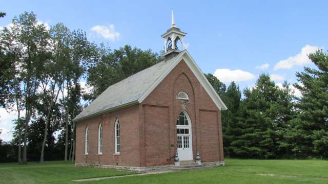
Photo: Aesopposea, Wikimedia Commons, CC BY-SA 3.0 · Wikimedia Commons
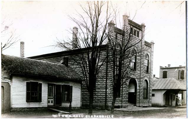
Photo: Columbus Metropolitan Library, via DPLA / Ohio Digital Network, public domain · Wikimedia Commons
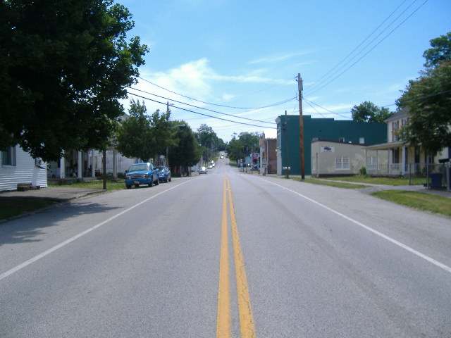
Photo: Aesopposea, Wikimedia Commons (own work), CC BY-SA 3.0 · Wikimedia Commons
Local history sources: en.wikipedia.org · en.wikipedia.org · en.wikipedia.org · en.wikipedia.org · kids.kiddle.co · archive.org · archive.org · commons.wikimedia.org · commons.wikimedia.org · commons.wikimedia.org · commons.wikimedia.org · commons.wikimedia.org · en.wikipedia.org · en.wikipedia.org · en.wikipedia.org
Historic places
2 places in Vernon Township, Clinton County on the National Register of Historic Places. Press a pin or a name for its whole record.
-
Cowan Creek Circular EnclosureSite · Wilmington · listed 1974
- Address
- SW of Wilmington
- Where
- Wilmington, Clinton County · ZIP 45177
- What it is
- Site
- Listed on the National Register
- 1974
- NRIS reference number
- 74001422
- Coordinates
- 39.39007, -83.91016
National Register file (NPS) ↗ Search Wikipedia ↗ Street map and directions ↗ On the Cracked Buckeye map
-
Pansy Methodist Church and School Historic DistrictHistoric district · Clarksville · listed 1973
- Address
- S of Clarksville on OH 730
- Where
- Clarksville, Clinton County · ZIP 45107
- What it is
- Historic district
- Listed on the National Register
- 1973
- NRIS reference number
- 73001398
- Coordinates
- 39.34884, -83.94464
National Register file (NPS) ↗ Search Wikipedia ↗ Street map and directions ↗ On the Cracked Buckeye map
Source: National Park Service, National Register of Historic Places point file. The listing year is shown where NPS's certification date agrees with the listing's reference number. Listing recognizes significance; it does not restrict a private owner.
Water
Ohio River intake at the plant's riverfront on Kellogg Ave in the California neighborhood, east Cincinnati The water here
- Western Water Company67% of residentsLittle Miami River valley wells (51%) plus Cincinnati Ohio River water (49%)
- Blanchester Village14% of residentsWhitacre Run, Stonelick Creek & West Fork East Fork Little Miami River reservoirs
- Clarksville Village11% of residentsOhio River (Miller Plant, ~88%) plus Great Miami Buried Valley Aquifer wells (~12%)
- Wilmington City8% of residentsCaesar Creek Lake (with Burtonville reservoirs/Cowan Creek as backup)
Hospitals, fire stations and more
Inside Vernon Township, Clinton County's boundary: 1 high-hazard dam, 1 Toxics Release Inventory facility, 3 spill cases and 1 mound or earthwork. Press a pin or a name for its whole record and its source.
High-hazard dams (1)
-
Cowan Lake Dam PoorCowan Creek · condition: poor
- Hazard class
- High: a failure would probably cost a life
- Condition
- Poor (assessed 03/07/2025)
- River or stream
- Cowan Creek
- Purpose
- Recreation
- Type
- Earth
- Height
- 63 ft
- Storage
- 24,974 acre-feet
- Completed
- 1947
- Owner type
- State
- County
- Clinton County
- Nearest town (NID)
- Clarksville
- Last inspection
- 06/11/2024
- Emergency action plan
- Yes
- NID ID
- OH00500
National Inventory of Dams record ↗ National Inventory of Dams (source) ↗ Street map and directions ↗
Source: U.S. Army Corps of Engineers National Inventory of Dams, August 2026. "High hazard" rates what a failure would cost downstream, not how likely one is; the condition is the state's assessment.
Facilities reporting toxic releases (1)
-
Valley Steel Products CoToxics Release Inventory · Clarksville
- Address
- Springhill Rd, Clarksville, OH 45113
- County
- Clinton County
- Status
- Reports to the Toxics Release Inventory (active)
- EPA program ID
- 45113VLLYSSPRIN
- EPA registry ID
- 110007713037
EPA facility record ↗ EPA Facility Registry Service (source) ↗ Street map and directions ↗
Source: EPA Facility Registry Service, Toxics Release Inventory reporters. Reporting a release is required of large users of listed chemicals; it is not by itself a violation.
Spills reported since 2021 (3)
-
Fuel Diesel / Diesel Fuel (Vehicle On Or Off Road)2025-09-22 · Vernon Twp
- Reported
- 2025-09-22
- What spilled
- Fuel Diesel / Diesel Fuel (Vehicle On Or Off Road)
- Where
- Vernon Twp, Clinton County
- Ohio EPA district office
- SWDO
- Ohio EPA case number
- 2509EPA0001581
Ohio EPA spill reports (source) ↗ Street map and directions ↗
-
Manure Nos (Not Specified) Reached water2023-08-01 · Vernon Twp
- Reported
- 2023-08-01
- What spilled
- Manure Nos (Not Specified)
- Reached a waterway
- 14 - East Fork Todd Fork
- Where
- Vernon Twp, Clinton County
- Ohio EPA district office
- SWDO
- Ohio EPA case number
- 2308EPA0001316
Ohio EPA spill reports (source) ↗ Street map and directions ↗
-
Sheen Rainbow / Hydrocarbon Reached water2022-05-26 · Vernon Twp
- Reported
- 2022-05-26
- What spilled
- Sheen Rainbow / Hydrocarbon
- Reached a waterway
- 99 - Unnamed
- Where
- Vernon Twp, Clinton County
- Ohio EPA district office
- SWDO
- Ohio EPA case number
- 2205EPA0000775
Ohio EPA spill reports (source) ↗ Street map and directions ↗
Source: Ohio EPA emergency response spill reports, 2021 to September 2026, one point per case where Ohio EPA placed it. A report is what the caller or responder recorded; amounts are often blank or estimated.
Mounds and earthworks (1)
-
Cowan Creek Circular EnclosureEarthwork · Adena culture (mound builder era; associated Cowan Creek Mound dated to c. AD 500)
- What it is
- Earthwork
- Age
- Adena culture (mound builder era; associated Cowan Creek Mound dated to c. AD 500)
- Where
- Southwest of Wilmington, Clinton County, now within Cowan Lake State Park, about 1 mile south of State Route 730
- County
- Clinton County
- Named in the history of
- Wilmington (city), Washington Township, Clinton County, Clinton County
- Map point
- from the site's Wikipedia article
Wikipedia article (point and source) ↗ Street map and directions ↗
Many mounds stand on private land; visit only those open to the public.
Source: the History records' native sites, each placed by its own Wikipedia article; sites no article places are named on the History card but not pinned.
Its ZIP codes
Each ZIP code that touches Vernon Township, Clinton County, with the share of its residents who live here and the same headline figures as the ZIP page.
Local government
How its elections and ballot issues came out and the state auditor's record.
Money issues on the ballot since 2025: 1 of 1 passed.
Ballot issues
| Date | Issue | For | Against | Result |
|---|---|---|---|---|
| 2025-05-06 | Issue: Vernon Twp Cemetery Levy (Renewal - 0.5 mill/5 yrs) (0.5 mills, renewal) | 358 | 243 | Passed (59.57% for) |
Elections for office
| Date | Office | Candidates and votes |
|---|---|---|
| 2021-11-02 | Trustee | Pete Myers 329, 52.56%; Daniel Speelman 297, 47.44% |
Winners in bold. Results from the county board of elections' official canvass unless marked. The county's results on file run through 2026-05-05; later elections are not loaded yet.
Auditor of State record
- No fiscal caution, watch or emergency on the Auditor of State's lists.
- Agreed Upon Procedures, 2023 to 2024, released 2025-07-29
On the November 3, 2026 ballot
Statewide question: State Issue 3: Voter ID
Local questions for Vernon Township, Clinton County, Clinton County and its school district:
- Clinton County: Miscellaneous, for Gas aggregation.
- Clinton County: Renews a 0.5-mill property tax levy to maintain & operate health department of Clinton County for 5 years, beginning in 2027.
- Clinton County: Renews a 2.35-mill property tax levy for the provide & maintain senior citizens services or facilities of Clinton County for 5 years, beginning in 2027.
Races, candidates and every question for an address: your ballot. County offices and judges are on your county board's sample ballot.
The county
Clinton County: 9 ZIP codes, 21 cities, villages and townships with pages here, 42,301 people (Census Bureau estimate, July 2025).
Nearby places
Quick answers
What county is Vernon Township, Ohio in?
Vernon Township, Clinton County is a township in Clinton County, Ohio, with 2,493 residents.
When was Vernon Township, Ohio founded?
Vernon Township, Clinton County was settled by 1803-09 (John McGregor's purchase and settlement in Murray's Survey No. 1032); laid out 1816 (Clarksville laid out); incorporated 1810 (township organized). Founders on record: early Virginia Military District patentees, including John McGregor. Source
How did Vernon Township, Ohio get its name?
The township's own namesake is not stated in the sources reviewed, but its village, Clarksville, was named for Sarah Clark Hadley, the wife of an early settler, when the village was laid out in 1816. Source
What ZIP code is Vernon Township, Ohio?
Vernon Township, Clinton County is served by ZIP codes 45113 and 45107; 45113 holds the largest share of its residents.
Where does Vernon Township, Ohio get its water?
The main water source for Vernon Township, Clinton County (Western Water Company): Ohio River intake at the plant's riverfront on Kellogg Ave in the California neighborhood, east Cincinnati.
Cite this page
Cite this page as:
Cracked Buckeye, "Vernon Township, Clinton County", https://crackedbuckeye.com/place/vernon-township-clinton-county/, built 2026-11-02, accessed [date].
How to cite · Report a correction · Built 2026-11-02