Local events in Adams Township, Clinton County
Nothing is posted for Adams Township itself yet; here is what is on within 20 miles. All local events in Adams Township, Clinton County
Know a calendar we should watch? Send the link
Checked October 20; the events page is refreshed daily.
How Adams Township, Clinton County began
Adams Township, in the western part of Clinton County, was organized by the county commissioners in 1849 out of pieces of Chester, Vernon and Union townships and named for President John Quincy Adams. It never grew an incorporated town of its own; the unincorporated crossroads of Ogden and Sligo, and the Eli Harvey House north of Clarksville, are its best-documented landmarks. Early settlement reached the township by 1812-1815, with families arriving from Virginia's Todd's Fork country, and today most residents draw water from Wilmington's municipal system or, since 1976, the rural Western Water Company cooperative.
Settled 1804 (Samuel Lee, first resident, near Springfield Meeting-House), incorporated 1849, by Clinton County Commissioners, from parts of Chester, Vernon and Union townships.
Where the name comes from
Named for President John Quincy Adams, one of ten Adams Townships in Ohio.
Before the town
The Hillside Haven Mound, an archaeological site at 1786 State Route 380 in Adams Township, was listed on the National Register of Historic Places on November 21, 1978. No Native village, trail or treaty line specific to Adams Township was found, but the 1881 county history records several local traces. Indian Branch, about half a mile east of Ogden, is said to have been named because a tribe made its home on its banks at times, probably during hunting trips, and cleared a patch of rich bottom land; settlers could still see the stumps cut with hatchets. The same history lists one of Clinton County's three prehistoric inclosures near Springfield Meeting-House, partly on David Curl's land: about an acre, surrounded by a ditch and an outer circular wall, with the meeting-house sheds and graveyard inside. Nearby on Curl's land is a mound about seventy-five feet across and eight feet high that its excavators called sacrificial: under the surface lay earth thrown over hot embers, then an altar of burnt clay baked to coarse glass, with decomposed human bones and a copper awl. A long mound near Sligo is the only non-circular mound the author knew in the county. The township lies in the Virginia Military District, opened to survey after the 1795 Treaty of Greenville.
Nations recorded here: Shawnee, Miami.
- Springfield Meeting-House inclosure and altar mound (earthwork) — near Springfield Meeting-House, partly on David Curl's land, Adams Township, prehistoric, undated; the 'sacrificial mound' reading is the 1881 author's interpretation (archive.org)
- Long mound near Sligo (mound) — near Sligo, Adams Township, prehistoric, undated (archive.org)
- Indian Branch encampment (camp) — about half a mile east of Ogden, Adams Township, before settlement, per the 1881 account (archive.org)
Timeline
- — Gen. William Lytle of Cincinnati is deeded 700 acres off Dudley's Survey No. 2,789 on Todd's Fork in payment for locating the 2,660-acre tract; Lytle's Creek is named for him.
- — Mordecai Mendenhall builds a grist mill on Todd's Fork, probably the first on that stream; it passes through Wright, Fallis, Hadley and others until it is taken down about 1867.
- — Eli Harvey and John Hadley build Hadley's Mill on Todd's Fork below Springfield Meeting-House; the first schoolhouse in the township is built the same year on Isaac Harvey's land.
- — Thomas Kersey settled on Todd's Fork adjoining his brother-in-law John Carter, among the area's early settlers.
- — Caleb Harvey builds a carding and fulling mill on Little Creek that is so busy it sometimes runs at night.
- — William Osborn came from Virginia, lived a year on the Samuel Harvey place on Lytle's Creek, then bought and settled 100 acres in the extreme southeastern part of the township.
- — John Holladay builds a saw mill on Lytle's Creek near the site of Ogden, adding a grist mill three years later.
- — Viewers report a road from Centre Meeting-House down Todd's Fork past Fallis's Mill; a second road from Shields's Mill on Cowan's Creek to Fallis's Mill follows in October.
- — A state road from Columbus to Cincinnati is surveyed; a commission in 1823 chooses a better route through Wilmington, Clarksville and the mouth of Todd's Fork, mainly along the divide between Todd's Fork and Lytle's Creek.
- — A frame schoolhouse with clay-chinked walls and slab benches is built on the Holaday (later Quinby) farm; the Friends of Springfield Monthly Meeting build their first schoolhouse in 1835.
- — The Goshen, Columbus & Wilmington turnpike is chartered in 1835 and built through the township mainly in 1839-40; a toll-gate house goes up at Sligo in 1840.
- — John Kimbrough opens a smithy at Sligo in 1839 and buys lots in 1841; the town is said to take its name from the Sligo Mills brand of iron used at the shop, itself named for Sligo in Ireland.
- — A post office is established at Sligo with George Slack as postmaster; it moves to Ogden on September 8, 1865.
- — Clinton County Commissioners organized Adams Township from parts of Chester, Vernon and Union townships, naming it for John Quincy Adams.
- — The first township election is held at John H. Moore's shop in Sligo, with Jeremiah Kimbrough, David Jenks and Peter Osborn chosen trustees and Jonathan D. Hadley clerk; Hiram Maden's survey gives the township 22 1/4 square miles.
- — Ogden, first called Linden, becomes a passenger and freight station on the Marietta & Cincinnati Railroad after neighbors raise $700; the name is changed because of confusion with Lyndon station.
- — Asa Green and John B. Carter lay out lots at Ogden; a store opens in 1864 under Quinby & Huffman and Ogden becomes the township's post office in 1865.
- — The 1881 county history cites three prehistoric inclosures in Clinton County, one at Springfield Meeting-House in Adams Township, and counts a long mound near Sligo as the only non-circular mound in the county.
- — Wilmington, just east of the township, built its first municipal water system after a mixed 1899 vote and a successful 1901 vote; township residents near the city line have drawn on it since.
- — Western Water Company was founded as a non-profit, customer-owned rural water system serving parts of Brown, Clermont, Clinton and Warren counties, working with USDA financing from its beginning.
Stories
The Harvey house that outlasted its neighbors
North of Clarksville on the Lebanon Road stands the Eli Harvey House, a brick farmhouse old enough and intact enough to have been added to the National Register of Historic Places in 1978. It is one of the very few individually landmarked buildings anywhere in Adams Township, which — unlike Wilmington or Blanchester nearby — never incorporated a village of its own; its history is the history of scattered farms rather than a downtown. The house's survival into the Register is really a record of a township that stayed agricultural and low-density long enough for its older buildings to remain standing rather than be replaced.
Sligo and the iron brand
Sligo was a crossroads on the Lebanon road before it was a town, and the 1881 county historian says it took its name from the brand on the iron used at the local smithy, which was made at the Sligo Mills in Pittsburgh, probably named for the town in northern Ireland. John Swindler was its first blacksmith and John Kimbrough kept the log shop from 1839, building a brick one in 1841; John Shields built the first toll-gate house on the new pike in 1840, and George Slack became first postmaster in 1844. The citizens of Sligo, which straddled the line between Chester and Vernon townships, petitioned in March 1849 for a township of their own with Sligo as its voting place, were told the survey enclosed too little land, and tried again; the township was established on May 1 and voted at John H. Moore's shop on May 12. When the railroad came in 1855 the new station at Ogden drew business away, and in 1865 the post office moved there to save the cost of carrying the mail between the two.
The altar mound at Springfield Meeting-House
Dr. B. Welch of Wilmington and J. M. Richardson began about 1867 to excavate the prehistoric works of Clinton County systematically, and their collection soon held more finely finished slate relics than the Smithsonian's, by the county history's account. One of the mounds they opened stood on David Curl's land near Springfield Meeting-House, beside an inclosure of about an acre surrounded by a ditch and wall that enclosed the Quaker meeting-house sheds and graveyard. About seventy-five feet across at the base and eight feet high, its height much reduced by plowing, it had a surface like the surrounding soil, then earth thrown over embers, then an altar of burnt clay slightly depressed in the center, fired so hot that wood and sand had fused to coarse glass. They found badly decomposed human bones and a copper awl, and other copper tools close by. The nineteenth-century investigators called it a sacrificial mound; the source offers no date or culture.
Photographs
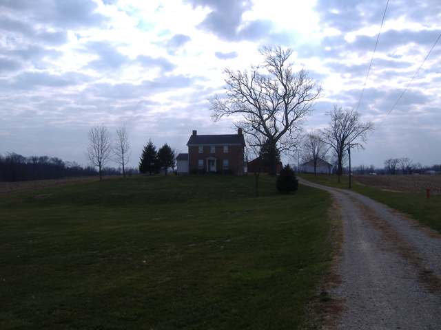
Photo: Aesopposea, CC BY-SA 3.0 · Wikimedia Commons
Local history sources: en.wikipedia.org · genealogytrails.com · archive.org · en.wikipedia.org · en.wikipedia.org · en.wikipedia.org · web.archive.org
Historic places
1 place in Adams Township, Clinton County on the National Register of Historic Places. Press a pin or a name for its whole record.
-
Harvey, Eli, HouseBuilding · Clarksville · listed 1978
- Address
- 1133 Lebanon Rd.
- Where
- Clarksville, Clinton County · ZIP 45113
- What it is
- Building
- Listed on the National Register
- 1978
- NRIS reference number
- 78002024
- Coordinates
- 39.44348, -83.96025
National Register file (NPS) ↗ Search Wikipedia ↗ Street map and directions ↗ On the Cracked Buckeye map
Source: National Park Service, National Register of Historic Places point file. The listing year is shown where NPS's certification date agrees with the listing's reference number. Listing recognizes significance; it does not restrict a private owner.
Water
Ohio River intake at the plant's riverfront on Kellogg Ave in the California neighborhood, east Cincinnati The water here
- Wilmington City54% of residentsCaesar Creek Lake (with Burtonville reservoirs/Cowan Creek as backup)
- Western Water Company41% of residentsLittle Miami River valley wells (51%) plus Cincinnati Ohio River water (49%)
- Clarksville Village5% of residentsOhio River (Miller Plant, ~88%) plus Great Miami Buried Valley Aquifer wells (~12%)
Hospitals, fire stations and more
Inside Adams Township, Clinton County's boundary: 3 public schools, 1 library and 5 spill cases. Press a pin or a name for its whole record and its source.
Public schools (3)
-
Clinton-Massie Elementary School5 of 5 stars · Clarksville
- Address
- 2380 Lebanon Rd, Clarksville, OH 45113
- School district
- Clinton-Massie Local School District
- Kind (NCES)
- Regular School
- Students, 2023-24
- 827
- Teachers (full-time equivalent)
- 41
- Report card, 2025-26
- 5 of 5 stars
- Performance index
- 86.6%
- Ohio building IRN
- 088963
- NCES school ID
- 390463904225
NCES school record ↗ Ohio School Report Card ↗ Street map and directions ↗
-
Clinton-Massie High School4.5 of 5 stars · Clarksville
- Address
- 2556 Lebanon Rd, Clarksville, OH 45113
- School district
- Clinton-Massie Local School District
- Kind (NCES)
- Regular School
- Students, 2023-24
- 461
- Teachers (full-time equivalent)
- 26
- Report card, 2025-26
- 4.5 of 5 stars
- Performance index
- 84.3%
- Four-year graduation rate
- 99.2%
- Ohio building IRN
- 006734
- NCES school ID
- 390463902540
NCES school record ↗ Ohio School Report Card ↗ Street map and directions ↗
-
Clinton-Massie Middle School3.5 of 5 stars · Clarksville
- Address
- 2556 Lebanon Rd, Clarksville, OH 45113
- School district
- Clinton-Massie Local School District
- Kind (NCES)
- Regular School
- Students, 2023-24
- 397
- Teachers (full-time equivalent)
- 22
- Report card, 2025-26
- 3.5 of 5 stars
- Performance index
- 80.5%
- Ohio building IRN
- 099853
- NCES school ID
- 390463904373
NCES school record ↗ Ohio School Report Card ↗ Street map and directions ↗
Source: NCES EDGE public school locations 2024-25 and Common Core of Data 2023-24 (type, students, teachers); Ohio School Report Cards 2025-26 (Department of Education and Workforce), matched by name within the district.
Public libraries (1)
-
Clinton Massie BranchBranch · Clarksville
- Address
- 2400 Lebanon Rd, Clarksville, OH 45113
- What it is
- Branch
- Library system
- Wilmington Public Library of Clinton County
- Open
- 2,358 hours a year, 52 weeks
- Building
- 3,980 sq ft
- System's visits, FY2024
- 110,864
- System's loans, FY2024
- 141,716
- People the system serves
- 28,434
- Phone
- (937) 289-1079
IMLS Public Libraries Survey (source) ↗ Street map and directions ↗
Source: IMLS Public Libraries Survey FY2024 (outlets and their systems). Any Ohio resident can get a free card at any Ohio public library.
Spills reported since 2021 (5)
-
Fuel Diesel / Diesel Fuel (Vehicle On Or Off Road)2025-05-22 · Adams Twp
- Reported
- 2025-05-22
- What spilled
- Fuel Diesel / Diesel Fuel (Vehicle On Or Off Road)
- Largest amount reported
- 100 gallons
- Where
- Adams Twp, Clinton County
- Ohio EPA district office
- SWDO
- Ohio EPA case number
- 2505EPA0000826
Ohio EPA spill reports (source) ↗ Street map and directions ↗
-
Fuel Diesel / Diesel Fuel (Vehicle On Or Off Road)2025-05-20 · Adams Twp
- Reported
- 2025-05-20
- What spilled
- Fuel Diesel / Diesel Fuel (Vehicle On Or Off Road)
- Largest amount reported
- 200 gallons
- Where
- Adams Twp, Clinton County
- Ohio EPA district office
- SWDO
- Ohio EPA case number
- 2505EPA0000803
Ohio EPA spill reports (source) ↗ Street map and directions ↗
-
Oil Hydraulic Fluid(S)2022-06-24 · Adams Twp
- Reported
- 2022-06-24
- What spilled
- Oil Hydraulic Fluid(S)
- Where
- Adams Twp, Clinton County
- Ohio EPA district office
- SWDO
- Ohio EPA case number
- 2206EPA0000961
Ohio EPA spill reports (source) ↗ Street map and directions ↗
-
Fuel Diesel / Diesel Fuel (Vehicle On Or Off Road)2021-11-01 · Adams Twp
- Reported
- 2021-11-01
- What spilled
- Fuel Diesel / Diesel Fuel (Vehicle On Or Off Road)
- Where
- Adams Twp, Clinton County
- Ohio EPA district office
- SWDO
- Ohio EPA case number
- 2111EPA0001690
Ohio EPA spill reports (source) ↗ Street map and directions ↗
-
Solid Waste Nos (Not Specified)2026-06-10 · Adams Twp
- Reported
- 2026-06-10
- What spilled
- Solid Waste Nos (Not Specified)
- Where
- Adams Twp, Clinton County
- Ohio EPA district office
- SWDO
- Ohio EPA case number
- 2606EPA0001031
Ohio EPA spill reports (source) ↗ Street map and directions ↗
Source: Ohio EPA emergency response spill reports, 2021 to September 2026, one point per case where Ohio EPA placed it. A report is what the caller or responder recorded; amounts are often blank or estimated.
Its ZIP codes
Each ZIP code that touches Adams Township, Clinton County, with the share of its residents who live here and the same headline figures as the ZIP page.
Local government
How its elections and ballot issues came out and the state auditor's record.
Elections for office
| Date | Office | Candidates and votes |
|---|---|---|
| 2021-11-02 | Trustee | Chris Collett 375, 51.3%; Tyler Webb 356, 48.7% |
Winners in bold. Results from the county board of elections' official canvass unless marked. The county's results on file run through 2026-05-05; later elections are not loaded yet.
Auditor of State record
- No fiscal caution, watch or emergency on the Auditor of State's lists.
- Agreed Upon Procedures, 2023 to 2024, released 2025-06-03
On the November 3, 2026 ballot
Statewide question: State Issue 3: Voter ID
Local questions for Adams Township, Clinton County, Clinton County and its school district:
- Clinton County: Miscellaneous, for Gas aggregation.
- Clinton County: Renews a 0.5-mill property tax levy to maintain & operate health department of Clinton County for 5 years, beginning in 2027.
- Clinton County: Renews a 2.35-mill property tax levy for the provide & maintain senior citizens services or facilities of Clinton County for 5 years, beginning in 2027.
Races, candidates and every question for an address: your ballot. County offices and judges are on your county board's sample ballot.
The county
Clinton County: 9 ZIP codes, 21 cities, villages and townships with pages here, 42,301 people (Census Bureau estimate, July 2025).
Nearby places
Quick answers
What county is Adams Township, Ohio in?
Adams Township, Clinton County is a township in Clinton County, Ohio, with 1,964 residents.
When was Adams Township, Ohio founded?
Adams Township, Clinton County was settled 1804 (Samuel Lee, first resident, near Springfield Meeting-House); incorporated 1849. Founders on record: Clinton County Commissioners, from parts of Chester, Vernon and Union townships. Source
How did Adams Township, Ohio get its name?
Named for President John Quincy Adams, one of ten Adams Townships in Ohio. Source
What ZIP code is Adams Township, Ohio?
Adams Township, Clinton County is served by ZIP codes 45113 and 45177; 45113 holds the largest share of its residents.
Where does Adams Township, Ohio get its water?
The main water source for Adams Township, Clinton County (Wilmington City): Ohio River intake at the plant's riverfront on Kellogg Ave in the California neighborhood, east Cincinnati.
Cite this page
Cite this page as:
Cracked Buckeye, "Adams Township, Clinton County", https://crackedbuckeye.com/place/adams-township-clinton-county/, built 2026-10-31, accessed [date].
How to cite · Report a correction · Built 2026-10-31