Local events in Cambridge
Nothing is posted for Cambridge itself yet; here is what is on within 10 miles. All local events in Cambridge
Know a calendar we should watch? Send the link
Checked October 20; the events page is refreshed daily.
Lakes near Cambridge
The history under the water: the valley before, the dam, the stories. All Ohio lakes
Notable people from Cambridge
Ohioans tied to this place, each with a sourced profile. All notable Ohioans

History from Cambridge
People and inventions tied to this place, each with its sources. All people · All inventions
How Cambridge began
Cambridge grew up around a ferry established in 1798 where Zane's Trace crossed Wills Creek; the town was platted in 1806 and became the seat of newly formed Guernsey County in 1810, named for settlers from the Isle of Guernsey who had arrived a few years earlier. The National Road reached Cambridge in 1828 and the first railroad in 1854, turning a stagecoach stop into a manufacturing and shipping center. In the late 1800s and early 1900s Cambridge became a nationally known glass town, home to the Cambridge Glass Company, Boyd Glass, and later Mosser Glass. The city's population peaked at 16,129 in 1930 and has declined since, standing near 10,000 today.
Settled 1798, platted 1806, by ferry at the Zane's Trace crossing of Wills Creek.
Where the name comes from
Historians have speculated Cambridge was named after either Cambridge, Maryland or Cambridge, Massachusetts; the county itself was named for the Isle of Guernsey in the English Channel, from which many early settlers emigrated.
Before the town
Guernsey County as a whole was used and inhabited by Delaware, Shawnee, Seneca and Mingo people into the early 1800s. In 1834, after most Ohio Native communities had already been forced west, a mixed band of Delaware, Shawnee, Wyandot and Seneca people numbering about 100 camped for more than ten days at 'Silver Cliff' near Cambridge, south of Gaston Avenue — one of the last recorded Native encampments in the county.
Nations recorded here: Lenape (Delaware), Shawnee, Mingo (Seneca-Cayuga), Wyandot.
- Silver Cliff encampment (camp) — south of Gaston Avenue, Cambridge, 1834 (ohiogenealogy.org)
Timeline
- — A ferry was established across Wills Creek where Zane's Trace crossed it, at the site that became Cambridge.
- — The first bridge authorized by the legislature of the Northwest Territory was built across Wills Creek at Cambridge.
- — Cambridge was formally platted.
- — Guernsey County was organized and Cambridge became the county seat after landowners donated land and buildings for the public offices.
- — The National Road reached Cambridge, improving its position on the route between Wheeling and Columbus.
- — The first railroad reached Cambridge, connecting it to Wheeling and Columbus and spurring real growth.
- — Cambridge's population peaked at 16,129 residents during the height of its glass and manufacturing era.
- — Cambridge experienced massive flooding in late June.
Stories
From ferry crossing to glass city
Cambridge began as nothing more than a place to cross Wills Creek: a ferry was running there by 1798 where Ebenezer Zane's new wilderness road met the water. For three decades the settlement stayed small, a stagecoach stop even after the National Road arrived in 1828. It was the railroad, reaching Cambridge in 1854 and later linking it directly to Wheeling and Columbus, that turned the town into a shipping point for the surrounding coal and clay country. By the late 1800s Cambridge had the rail access, natural gas, and skilled labor to support glassmaking, and the Cambridge Glass Company, founded in 1901, became one of the most celebrated American glass producers of the 20th century, known for its colored 'Cambridge glass' pressed and blown ware. Boyd Glass and later Mosser Glass continued the tradition after Cambridge Glass closed in 1958, and Cambridge is still marketed today as a center for glass collectors.
Photographs
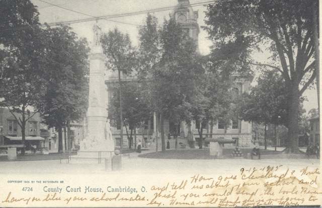
Photo: Miami University Libraries Digital Collections, via Wikimedia Commons, no known copyright restrictions · Wikimedia Commons
Local history sources: en.wikipedia.org · en.wikipedia.org · ohiogenealogy.org · en.wikipedia.org · commons.wikimedia.org
Historic places
7 places in Cambridge on the National Register of Historic Places. Press a pin or a name for its whole record.
-
Berwick HotelBuilding · Cambridge · listed 1983
- Address
- 600--615 Wheeling Ave.
- Where
- Cambridge, Guernsey County · ZIP 43725
- What it is
- Building
- Listed on the National Register
- 1983
- NRIS reference number
- 83001975
- Coordinates
- 40.02516, -81.59306
National Register file (NPS) ↗ Search Wikipedia ↗ Street map and directions ↗ On the Cracked Buckeye map
-
Broom BuildingBuilding · Cambridge · listed 1983
- Address
- 701 Wheeling Ave.
- Where
- Cambridge, Guernsey County · ZIP 43725
- What it is
- Building
- Listed on the National Register
- 1983
- NRIS reference number
- 83001976
- Coordinates
- 40.02499, -81.59166
National Register file (NPS) ↗ Search Wikipedia ↗ Street map and directions ↗ On the Cracked Buckeye map
-
McCracken-McFarland HouseBuilding · Cambridge · listed 1979
- Address
- 216 N. 8th St.
- Where
- Cambridge, Guernsey County · ZIP 43725
- What it is
- Building
- Listed on the National Register
- 1979
- NRIS reference number
- 79001848
- Coordinates
- 40.02680, -81.58980
National Register file (NPS) ↗ Search Wikipedia ↗ Street map and directions ↗ On the Cracked Buckeye map
-
McCracken-Scott HouseBuilding · Cambridge · listed 1978
- Address
- 819 Steubenville Ave.
- Where
- Cambridge, Guernsey County · ZIP 43725
- What it is
- Building
- Listed on the National Register
- 1978
- NRIS reference number
- 78002071
- Coordinates
- 40.02644, -81.58933
National Register file (NPS) ↗ Search Wikipedia ↗ Street map and directions ↗ On the Cracked Buckeye map
-
McCreary-Burnworth HouseBuilding · Cambridge · listed 1982
- Address
- 220 Highland Ave.
- Where
- Cambridge, Guernsey County · ZIP 43725
- What it is
- Building
- Listed on the National Register
- 1982
- NRIS reference number
- 82003574
- Coordinates
- 40.02630, -81.58112
National Register file (NPS) ↗ Search Wikipedia ↗ Street map and directions ↗ On the Cracked Buckeye map
-
Sarchet-Burgess HouseBuilding · Cambridge · listed 1987
- Address
- 145 W. Eighth St.
- Where
- Cambridge, Guernsey County · ZIP 43725
- What it is
- Building
- Listed on the National Register
- 1987
- NRIS reference number
- 87000808
- Coordinates
- 40.02598, -81.59038
National Register file (NPS) ↗ Search Wikipedia ↗ Street map and directions ↗ On the Cracked Buckeye map
-
Taylor, Colonel Joseph, HouseBuilding · Cambridge · listed 2008
- Address
- 633 Upland Rd.
- Where
- Cambridge, Guernsey County · ZIP 43725
- What it is
- Building
- Listed on the National Register
- 2008
- NRIS reference number
- 08000801
- Coordinates
- 40.03363, -81.59220
National Register file (NPS) ↗ Search Wikipedia ↗ Street map and directions ↗ On the Cracked Buckeye map
Source: National Park Service, National Register of Historic Places point file. The listing year is shown where NPS's certification date agrees with the listing's reference number. Listing recognizes significance; it does not restrict a private owner.
Water
Wills Creek, impounded in the Cambridge (Wills Creek) Reservoir northwest of the city, with a supplemental direct Wills Creek intake The water here
- Cambridge, City Of89% of residentsWills Creek via Cambridge Reservoir + Wills Creek direct intake
- Byesville4% of residentslocal wells (mine-pool/groundwater under influence of surface water)
- Western Guernsey Regional Water District4% of residentsWills Creek via Cambridge Reservoir + Wills Creek direct intake
- Guernsey Co. Water Dept.3% of residentsWills Creek via Cambridge Reservoir + Wills Creek direct intake
Hospitals, fire stations and more
Inside Cambridge's boundary: 1 hospital, 2 health centers, 1 dialysis center, 2 nursing homes, 1 fire or EMS station, 5 public schools, 1 private school, 1 library, 3 museums, 2 police stations, 5 public charging sites, 1 shale or injection well, 1 Superfund site, 8 Toxics Release Inventory facilities, 1 station or terminal and 11 spill cases. Press a pin or a name for its whole record and its source.
Hospitals (1)
-
Southeastern Oh Regional Med CtrGeneral hospital · Cambridge
- What it is
- General hospital
- Address
- 1341 Clark Street, Cambridge, OH 43725
- County
- Guernsey County
- Beds
- 195
- Helipad
- Yes
- Ownership
- Non-profit
- Medicare overall rating
- 4 of 5 stars
- Emergency department (Medicare)
- Yes
- Medicare reports it as
- Southeastern Ohio Regional Medical Center
- Phone
- (740) 439-8112
- Medicare ID
- 360203
Medicare Care Compare ↗ Where HIFLD got this record ↗ HIFLD hospitals (source) ↗ Street map and directions ↗
Source: HIFLD hospitals inventory via FEMA (closed hospitals it still lists left out, hospitals opened since added), with Medicare Care Compare ratings matched by name and address.
Community health centers (2)
-
Muskingum Valley Health Center - CambridgeHealth center · Cambridge
- Run by
- a federally qualified health center
- Setting
- Clinic
- City
- Cambridge
- Coordinates
- 40.03922, -81.57692
Find a Health Center (HRSA) ↗ HRSA data (source) ↗ Street map and directions ↗
-
Muskingum Valley Health Centers - Cambridge MATHealth center · Cambridge
- Run by
- a federally qualified health center
- Setting
- Clinic
- City
- Cambridge
- Coordinates
- 40.02826, -81.58297
Find a Health Center (HRSA) ↗ HRSA data (source) ↗ Street map and directions ↗
Source: HRSA health center service delivery sites, active, September 2026 (school-based sites left out). Health centers see patients whether or not they have insurance, with fees on a sliding scale.
Dialysis centers (1)
-
Kidney Care Of Centers Of CambridgeDialysis · Cambridge
- Address
- 6901 Glenn Highway Suite A, Cambridge, OH 43725
- Dialysis stations
- 13
- Medicare star rating
- 4 of 5 stars
- Services
- in-center hemodialysis, peritoneal dialysis, home hemodialysis training
- Ownership
- for profit
- Chain
- American Renal Associates
- Medicare certified since
- 2013-02-21
- Phone
- (740) 439-1431
- Medicare ID
- 362790
Medicare Care Compare ↗ CMS dialysis facility list (source) ↗ Street map and directions ↗
Source: CMS dialysis facility list, September 2026, geocoded with the Census Bureau batch geocoder (an address it could not place sits at its ZIP center).
Nursing homes (2)
-
Embassy of Cambridge2 of 5 stars · Cambridge
- Address
- 1471 Wills Creek Valley Drive, Cambridge, OH 43725
- Certified beds
- 95
- Residents on an average day
- 72
- Medicare overall rating
- 2 of 5 stars
- Health inspections
- 1 of 5 stars
- Staffing
- 1 of 5 stars
- Quality measures
- 5 of 5 stars
- Penalties since 2023
- 4 fines totalling $131,018 (latest 2024-10-24)
- Ownership
- For profit - Corporation
- Chain
- EMBASSY HEALTHCARE
- Takes
- Medicare and Medicaid
- Phone
- (740) 439-4437
- Medicare ID
- 365770
Medicare Care Compare ↗ CMS nursing home data (source) ↗ Street map and directions ↗
-
The Enclave at Cambridge1 of 5 stars · Cambridge
- Address
- 8420 Georgetown Road, Cambridge, OH 43725
- Certified beds
- 78
- Residents on an average day
- 43
- Medicare overall rating
- 1 of 5 stars
- Health inspections
- 1 of 5 stars
- Staffing
- 3 of 5 stars
- Quality measures
- 4 of 5 stars
- Penalties since 2023
- 2 fines totalling $194,587, 2 payment denials (latest 2024-01-31)
- Ownership
- For profit - Limited Liability company
- Takes
- Medicare and Medicaid
- Phone
- (740) 439-4401
- Medicare ID
- 366273
Medicare Care Compare ↗ CMS nursing home data (source) ↗ Street map and directions ↗
Source: CMS Care Compare nursing home provider and penalties files; Medicare star ratings run 1 to 5.
Fire and EMS stations (1)
-
Cambridge Fire DepartmentCambridge
- Address
- 902 Gaston Avenue, Cambridge, OH 43725
- Coordinates
- 40.02307, -81.58799
USGS National Map structures (source) ↗ Street map and directions ↗
Source: USGS National Map structures (most Ohio records last updated 2019 to 2022), checked against the Columbus and Cleveland station lists. The department that answers a call is set by jurisdiction and mutual aid, not by distance.
Public schools (5)
-
Cambridge City PreschoolCambridge
- Address
- 518 S 8th St, Cambridge, OH 43725
- Kind (NCES)
- Regular School
- Students, 2023-24
- 77
- NCES school ID
- 390436906003
-
Cambridge High School3 of 5 stars · Cambridge
- Address
- 1401 Deerpath Dr, Cambridge, OH 43725
- School district
- Cambridge City School District
- Kind (NCES)
- Regular School
- Students, 2023-24
- 488
- Teachers (full-time equivalent)
- 34.79
- Report card, 2025-26
- 3 of 5 stars
- Performance index
- 64.3%
- Four-year graduation rate
- 96.6%
- Ohio building IRN
- 004622
- NCES school ID
- 390436900225
NCES school record ↗ Ohio School Report Card ↗ Street map and directions ↗
-
Cambridge Intermediate School2 of 5 stars · Cambridge
- Address
- 1451 Deerpath Dr, Cambridge, OH 43725
- School district
- Cambridge City School District
- Kind (NCES)
- Regular School
- Students, 2023-24
- 373
- Teachers (full-time equivalent)
- 23
- Report card, 2025-26
- 2 of 5 stars
- Performance index
- 65.6%
- Ohio building IRN
- 148817
- NCES school ID
- 390436904199
NCES school record ↗ Ohio School Report Card ↗ Street map and directions ↗
-
Cambridge Middle School3 of 5 stars · Cambridge
- Address
- 1400 Deerpath Dr, Cambridge, OH 43725
- School district
- Cambridge City School District
- Kind (NCES)
- Regular School
- Students, 2023-24
- 402
- Teachers (full-time equivalent)
- 30.13
- Report card, 2025-26
- 3 of 5 stars
- Performance index
- 60.4%
- Ohio building IRN
- 004614
- NCES school ID
- 390436900224
NCES school record ↗ Ohio School Report Card ↗ Street map and directions ↗
-
Cambridge Primary School1 of 5 stars · Cambridge
- Address
- 1115 Clairmont Ave, Cambridge, OH 43725
- School district
- Cambridge City School District
- Kind (NCES)
- Regular School
- Students, 2023-24
- 465
- Teachers (full-time equivalent)
- 29
- Report card, 2025-26
- 1 of 5 stars
- Ohio building IRN
- 148809
- NCES school ID
- 390436904198
NCES school record ↗ Ohio School Report Card ↗ Street map and directions ↗
Source: NCES EDGE public school locations 2024-25 and Common Core of Data 2023-24 (type, students, teachers); Ohio School Report Cards 2025-26 (Department of Education and Workforce), matched by name within the district.
Private schools (1)
-
St Benedict Elementary SchoolPrivate, Catholic · Cambridge
- Address
- 220 N 7Th St, Cambridge, OH 43725
- Kind
- Catholic
- Students, 2023-24
- 61
- Teachers (full-time equivalent)
- 7.9
- Students per teacher
- 7.72152
- Phone
- (740) 432-6751
- NCES private school ID
- 01060513
Source: NCES Private School Survey 2023-24.
Public libraries (1)
-
Guernsey County District Public LibraryCentral library · Cambridge
- Address
- 800 Steubenville Ave., Cambridge, OH 43725
- What it is
- Central library
- Library system
- Guernsey County District Public Library
- Open
- 2,418 hours a year, 52 weeks
- Building
- 22,722 sq ft
- System's visits, FY2024
- 84,864
- System's loans, FY2024
- 251,086
- People the system serves
- 38,438
- Phone
- (740) 432-5946
IMLS Public Libraries Survey (source) ↗ Street map and directions ↗
Source: IMLS Public Libraries Survey FY2024 (outlets and their systems). Any Ohio resident can get a free card at any Ohio public library.
Museums, historical societies, gardens and zoos (3)
-
Guernsey County Historical SocietyHistorical society · Cambridge
- What it is
- Historical society
- City
- Cambridge
- Coordinates
- 40.02681, -81.58980
Search Wikipedia ↗ IMLS Museum Data Files (source) ↗ Street map and directions ↗
The museum list is IMLS's 2018 file; a museum may have closed or moved since.
-
National Museum Of Cambridge GlassMuseum · Cambridge
- What it is
- Museum
- City
- Cambridge
- Coordinates
- 40.02397, -81.58837
Search Wikipedia ↗ IMLS Museum Data Files (source) ↗ Street map and directions ↗
The museum list is IMLS's 2018 file; a museum may have closed or moved since.
-
Old Cambridge Conservation AssociationHistorical society · Cambridge
- What it is
- Historical society
- City
- Cambridge
- Coordinates
- 40.02730, -81.58833
Search Wikipedia ↗ IMLS Museum Data Files (source) ↗ Street map and directions ↗
The museum list is IMLS's 2018 file; a museum may have closed or moved since.
Source: IMLS Museum Data Files, 2018.
Police stations (2)
-
Cambridge Police DepartmentCambridge
- Address
- 601 Southgate Parkway, Cambridge, OH 43725
- Coordinates
- 40.01865, -81.58539
USGS National Map structures (source) ↗ Street map and directions ↗
-
Guernsey County Sheriff's OfficeCambridge
- Address
- 601 Southgate Parkway, Cambridge, OH 43725
- Coordinates
- 40.01857, -81.58527
USGS National Map structures (source) ↗ Street map and directions ↗
Source: USGS National Map structures, police stations, corrected and completed by hand (September 2026). The department that answers a call is set by jurisdiction, not by distance.
Public EV charging (5)
-
Cambridge, OH Rechargery Relay - Southgate Rd DC fast8 DC fast · Cambridge
- Address
- 61600 Southgate Rd, Cambridge, OH 43725
- Ports
- 8 DC fast
- Plugs
- CCS, Tesla (NACS)
- Network
- IONNA
- Hours
- 24 hours daily
- Phone
- 833-466-2474
Station Locator (NREL) ↗ Alternative Fuels Data Center (source) ↗ Street map and directions ↗
-
GEORGETOWNVINE GEORGETOWN 012 Level 2 · Cambridge
- Address
- 62920 Georgetown Rd, Cambridge, OH 43725
- Ports
- 2 Level 2
- Plugs
- J1772
- Network
- ChargePoint Network
- Hours
- 24 hours daily
- Phone
- 888-758-4389
Station Locator (NREL) ↗ Alternative Fuels Data Center (source) ↗ Street map and directions ↗
-
Guernsey County Community Development Corp1 Level 2 · Cambridge
- Address
- 905 Wheeling Ave, Cambridge, OH 43725
- Ports
- 1 Level 2
- Plugs
- J1772
- Network
- Non-Networked
- Hours
- 24 hours daily
- Phone
- 740-439-0020
Station Locator (NREL) ↗ Alternative Fuels Data Center (source) ↗ Street map and directions ↗
-
Sheetz - Tesla Supercharger DC fast8 DC fast · Cambridge
- Address
- 2101 Southgate Parkway, Cambridge, OH 43725
- Ports
- 8 DC fast
- Plugs
- Tesla (NACS)
- Network
- Tesla
- Hours
- 24 hours daily. Please check Tesla's online station map to see if an adapter is required at this location.
- Phone
- 877-798-3752
Station Locator (NREL) ↗ Alternative Fuels Data Center (source) ↗ Street map and directions ↗
-
Walmart 3262 (Cambridge, OH) DC fast4 DC fast · Cambridge
- Address
- 61205 Southgate Rd, Cambridge, OH 43725
- Ports
- 4 DC fast
- Plugs
- CCS, CHAdeMO
- Network
- Electrify America
- Hours
- 24 hours daily
- Phone
- 833-632-2778
Station Locator (NREL) ↗ Alternative Fuels Data Center (source) ↗ Street map and directions ↗
Source: NREL Alternative Fuels Data Center station list (May 2026), public and open stations, the posts at one address counted as one site.
Shale and injection wells (1)
-
Sos D-2 (Swiw #14) 2 InjectionInjection well (Class II)
- What it is
- Injection well (Class II)
- Operator
- Silcor Oilfield Services Inc
- County
- Guernsey County
- API well number
- 34059243320000
- Coordinates
- 39.99386, -81.57836
ODNR oil and gas wells (source) ↗ Street map and directions ↗
Source: ODNR Division of Oil and Gas Resources well inventory (September 2026): drilled Utica, Marcellus and horizontal wells and Class II injection wells not plugged. Older vertical wells are on the full map.
Superfund sites (1)
-
Lh IncorporationSuperfund program · Cambridge
- Address
- 1502 Beckett Avenue, Cambridge, OH 43725
- County
- Guernsey County
- Status
- Superfund program site, not on the National Priorities List
- EPA program ID
- OHD980586671
- EPA registry ID
- 110009304733
EPA facility record ↗ EPA Facility Registry Service (source) ↗ Street map and directions ↗
Source: EPA Facility Registry Service, Superfund (SEMS) and National Priorities List sites. Many program sites were assessed and needed no cleanup.
Facilities reporting toxic releases (8)
-
Ametek March ElectricToxics Release Inventory · Cambridge
- Address
- 725 Water St., Cambridge, OH 43725
- County
- Guernsey County
- Status
- Reports to the Toxics Release Inventory (active)
- EPA program ID
- 43725MTKMR725WA
- EPA registry ID
- 110002109931
EPA facility record ↗ EPA Facility Registry Service (source) ↗ Street map and directions ↗
-
Bluescope Coated Products, Llc (0630010006)Toxics Release Inventory · Cambridge
- Address
- 530 North Second Street, Cambridge, OH 43725
- County
- Guernsey County
- Status
- Reports to the Toxics Release Inventory (open)
- EPA program ID
- 43725GSMTH530NO
- EPA registry ID
- 110000384548
EPA facility record ↗ EPA Facility Registry Service (source) ↗ Street map and directions ↗
-
Colgate-Palmolive CoToxics Release Inventory · Cambridge
- Address
- 8800 Guernsey Indl. Blvd., Cambridge, OH 43725
- County
- Guernsey County
- Status
- Reports to the Toxics Release Inventory (active)
- EPA program ID
- 43725CLGTP8800G
- EPA registry ID
- 110000384539
EPA facility record ↗ EPA Facility Registry Service (source) ↗ Street map and directions ↗
-
Optiblend Industries-CambridgeToxics Release Inventory · Cambridge
- Address
- 6820 Manila Rd., Cambridge, OH 43725
- County
- Guernsey County
- Status
- Reports to the Toxics Release Inventory (active)
- EPA program ID
- 4372WPTBLN682MA
- EPA registry ID
- 110067082882
EPA facility record ↗ EPA Facility Registry Service (source) ↗ Street map and directions ↗
-
Quanex Ig SystemsToxics Release Inventory · Cambridge
- Address
- 800 Cochran Ave, Cambridge, OH 43725
- County
- Guernsey County
- Status
- Reports to the Toxics Release Inventory (active)
- EPA program ID
- 43725NCRCR800CO
- EPA registry ID
- 110070543873
EPA facility record ↗ EPA Facility Registry Service (source) ↗ Street map and directions ↗
-
Quanex Ig Systems Inc Dba Quanex Custom MixingToxics Release Inventory · Cambridge
- Address
- 804 Byesville Rd, Cambridge, OH 43725
- County
- Guernsey County
- Status
- Reports to the Toxics Release Inventory (active)
- EPA program ID
- 43725LMCST804BY
- EPA registry ID
- 110006234208
EPA facility record ↗ EPA Facility Registry Service (source) ↗ Street map and directions ↗
-
Randall Textron IncToxics Release Inventory · Cambridge
- Address
- 224 N 3Rd St, Cambridge, OH 43725
- County
- Guernsey County
- Status
- Reports to the Toxics Release Inventory (closed)
- EPA program ID
- 43725RNDLL224N3
- EPA registry ID
- 110004622187
EPA facility record ↗ EPA Facility Registry Service (source) ↗ Street map and directions ↗
-
Tw Metals Co IncToxics Release Inventory · Cambridge
- Address
- 2105 Larrick Rd., Cambridge, OH 43725
- County
- Guernsey County
- Status
- Reports to the Toxics Release Inventory (active)
- EPA program ID
- 43725TWMTL2105L
- EPA registry ID
- 110000384557
EPA facility record ↗ EPA Facility Registry Service (source) ↗ Street map and directions ↗
Source: EPA Facility Registry Service, Toxics Release Inventory reporters. Reporting a release is required of large users of listed chemicals; it is not by itself a violation.
Stations and terminals (1)
-
SheetzIntercity bus stop · Greyhound Lines
- What it is
- Intercity bus stop
- Operator
- Greyhound Lines
- City
- Cambridge
- Coordinates
- 40.00699, -81.57682
BTS Intermodal Passenger Connectivity Database (source) ↗ Street map and directions ↗
Source: BTS Intermodal Passenger Connectivity Database and National Transit Map (2025). Bus stops are counted on the card and drawn on the full map.
Spills reported since 2021 (11)
-
Sewage Human Reached water2025-10-10 · Cambridge
- Reported
- 2025-10-10
- What spilled
- Sewage Human
- Reached a waterway
- 30 - Wills Creek
- Where
- Cambridge, Guernsey County
- Ohio EPA district office
- SEDO
- Ohio EPA case number
- 2510EPA0001676
Ohio EPA spill reports (source) ↗ Street map and directions ↗
-
Nitric Acid (Hno3)2025-08-13 · Cambridge
- Reported
- 2025-08-13
- What spilled
- Nitric Acid (Hno3)
- Where
- Cambridge, Guernsey County
- Ohio EPA district office
- SEDO
- Ohio EPA case number
- 2508EPA0001358
Ohio EPA spill reports (source) ↗ Street map and directions ↗
-
Mercury / Quicksilver (Hg)2025-05-13 · Cambridge
- Reported
- 2025-05-13
- What spilled
- Mercury / Quicksilver (Hg)
- Where
- Cambridge, Guernsey County
- Ohio EPA district office
- SEDO
- Ohio EPA case number
- 2505EPA0000756
Ohio EPA spill reports (source) ↗ Street map and directions ↗
-
Oil Transformer Non Pcb2025-03-16 · Cambridge
- Reported
- 2025-03-16
- What spilled
- Oil Transformer Non Pcb
- Largest amount reported
- 41 gallons
- Where
- Cambridge, Guernsey County
- Ohio EPA district office
- SEDO
- Ohio EPA case number
- 2503EPA0000373
Ohio EPA spill reports (source) ↗ Street map and directions ↗
-
Material Unknown2023-10-08 · Cambridge
- Reported
- 2023-10-08
- What spilled
- Material Unknown
- Where
- Cambridge, Guernsey County
- Ohio EPA district office
- SEDO
- Ohio EPA case number
- 2310EPA0001735
Ohio EPA spill reports (source) ↗ Street map and directions ↗
-
Sheen Rainbow / Hydrocarbon Reached water2023-09-29 · Cambridge
- Reported
- 2023-09-29
- What spilled
- Sheen Rainbow / Hydrocarbon
- Reached a waterway
- 30 - Wills Creek
- Where
- Cambridge, Guernsey County
- Ohio EPA district office
- SEDO
- Ohio EPA case number
- 2309EPA0001696
Ohio EPA spill reports (source) ↗ Street map and directions ↗
-
Waste Water2022-10-01 · Cambridge
- Reported
- 2022-10-01
- What spilled
- Waste Water
- Where
- Cambridge, Guernsey County
- Ohio EPA district office
- SEDO
- Ohio EPA case number
- 2210EPA0001497
Ohio EPA spill reports (source) ↗ Street map and directions ↗
-
Brine Oil And Gas Related Reached water2021-06-25 · Cambridge
- Reported
- 2021-06-25
- What spilled
- Brine Oil And Gas Related
- Largest amount reported
- 175 gallons
- Reached a waterway
- 99 - Unnamed
- Where
- Cambridge, Guernsey County
- Ohio EPA district office
- SEDO
- Ohio EPA case number
- 2106EPA0000933
Ohio EPA spill reports (source) ↗ Street map and directions ↗
-
Fuel Diesel / Diesel Fuel (Vehicle On Or Off Road)2021-05-20 · Cambridge
- Reported
- 2021-05-20
- What spilled
- Fuel Diesel / Diesel Fuel (Vehicle On Or Off Road)
- Largest amount reported
- 60 gallons
- Where
- Cambridge, Guernsey County
- Ohio EPA district office
- SEDO
- Ohio EPA case number
- 2105EPA0000710
Ohio EPA spill reports (source) ↗ Street map and directions ↗
-
Methyl Alcohol / Methanol / Naphtha (Ch3Oh)2021-02-17 · Cambridge Twp
- Reported
- 2021-02-17
- What spilled
- Methyl Alcohol / Methanol / Naphtha (Ch3Oh)
- Where
- Cambridge Twp, Guernsey County
- Ohio EPA district office
- SEDO
- Ohio EPA case number
- 2102EPA0000212
Ohio EPA spill reports (source) ↗ Street map and directions ↗
-
Oil Vegetable / Bio2026-03-26 · Cambridge
- Reported
- 2026-03-26
- What spilled
- Oil Vegetable / Bio
- Where
- Cambridge, Guernsey County
- Ohio EPA district office
- SEDO
- Ohio EPA case number
- 2603EPA0000495
Ohio EPA spill reports (source) ↗ Street map and directions ↗
Source: Ohio EPA emergency response spill reports, 2021 to September 2026, one point per case where Ohio EPA placed it. A report is what the caller or responder recorded; amounts are often blank or estimated.
Its ZIP codes
Each ZIP code that touches Cambridge, with the share of its residents who live here and the same headline figures as the ZIP page.
| ZIP | Share | Water | Radon | Home value | Schools | Flood |
|---|---|---|---|---|---|---|
| 43725 Cambridge | 52% | Wills Creek, impounded in the Cambridge (Wills Creek) Reservoir northwest of the city, with a supplemental direct Wills Creek intake | 6.7 pCi/L average radon | Appraisal records without year built | Cambridge City · 2.5 stars overall | 7.1% of residents in the 1% floodplain |
Local government
Who holds office in Cambridge, how its elections and ballot issues came out, and the state auditor's record.
Money issues on the ballot since 2020: 5 of 5 passed.
Ballot issues
| Date | Issue | For | Against | Result |
|---|---|---|---|---|
| 2025-11-04 | Issue: Cambridge City Fire - Renewal | 479 | 199 | Passed (70.65% for) |
| 2023-11-07 | Issue: Cambridge City Fire 3.9 mills (3.9 mills) | 1,400 | 815 | Passed (63.21% for) |
| 2023-11-07 | Issue: Cambridge City Fire 3 mills (3.0 mills) | 1,432 | 783 | Passed (64.65% for) |
| 2023-05-02 | Issue: Cambridge City EMS - Additional 3.2 mills (3.2 mills) | 449 | 234 | Passed (65.74% for) |
| 2020-11-03 | Issue: Cambridge City Fire Levy | 2,565 | 1,138 | Passed (69.27% for), unofficial |
Elections for office
| Date | Office | Candidates and votes |
|---|---|---|
| 2025-11-04 | Treasurer | Michael A. Sikora (DEM) 514, 100.0% |
| 2025-11-04 | School Board Member | David Evancho 754, 33.62%; Heath Hayes 749, 33.39%; Dave Peoples 740, 32.99% |
| 2025-11-04 | President Of Council | Jeff A. Leonard (REP) 485, 100.0% |
| 2025-11-04 | Council Ward 4 | Mike Zaleski (REP) 148, 100.0% |
| 2025-11-04 | Council Ward 3 | John R. Wolverton (DEM) 170, 100.0% |
| 2025-11-04 | Council Ward 2 | Kim McMillen (DEM) 78, 100.0% |
| 2025-11-04 | Council Ward 1 | Steve Mourer (DEM) 115, 100.0% |
| 2025-11-04 | Council At Large | Tim Evancho (REP) 415, 32.78%; Ernest R. Gardner Jr. (REP) 394, 31.12%; Thomas J. Laughman II (DEM) 457, 36.1% |
| 2024-03-19 | C Central Comm Rep | Debrah Sue McKee 160, 100.0% |
| 2024-03-19 | B Central Comm Dem | Maxine B. Douglass 38, 100.0% |
| 2024-03-19 | A Central Comm Rep | Donald D. Brown 171, 100.0% |
| 2024-03-19 | A Central Comm Dem | Linda J. Gothard 30, 100.0% |
| 2023-11-07 | School Board Member | Sarah Flaten 713, 12.52%; Rachel Kanski 1,031, 18.11%; Ronald B. Miller 1,549, 27.21%; Steven A. Taylor 2,400, 42.16% |
| 2023-11-07 | President Of Council | William S. Cowgill (REP) 1,792, 100.0% |
| 2023-11-07 | Mayor | Tom Orr (REP) 1,910, 100.0% |
| 2023-11-07 | Director Of Law | William Ferguson (DEM) 1,645, 100.0% |
| 2023-11-07 | Council Ward 4 | Mike Zaleski (REP) 541, 100.0% |
| 2023-11-07 | Council Ward 3 | John R. Wolverton (DEM) 512, 100.0% |
| 2023-11-07 | Council Ward 2 | Kim McMillen (DEM) 241, 100.0% |
| 2023-11-07 | Council Ward 1 | Jeff A. Leonard (REP) 220, 45.45%; Steve Mourer (DEM) 264, 54.55% |
| 2023-11-07 | Council At Large | Tim Evancho (REP) 1,253, 36.23%; Donna Hill (REP) 946, 27.36%; Thomas J. Laughman II (DEM) 1,259, 36.41% |
| 2023-11-07 | Auditor | Conner Johnson (REP) 1,705, 100.0% |
| 2020-03-17 | C Central Committee Member (REP) | Debrah Sue McKee 135, 100.0% |
| 2020-03-17 | C Central Committee Member (DEM) | No Candidate Filed 0 |
| 2020-03-17 | B Central Committee Member (REP) | No Candidate Filed 0 |
Winners in bold. Results from the county board of elections' official canvass unless marked.
Auditor of State record
- No fiscal caution, watch or emergency on the Auditor of State's lists.
- Financial Health Indicators (the Auditor of State's 17 measures; critical / cautionary / positive): 2020 0 / 0 / 17; 2021 1 / 3 / 13; 2022 3 / 2 / 12; 2023 0 / 5 / 12; 2024 0 / 1 / 16; 2025 0 / 1 / 16.
- Financial Audit, 2025, released 2026-08-06
- Financial Audit, 2024, released 2025-10-07
- Financial Audit, 2023, released 2024-07-18
The county
Guernsey County: 14 ZIP codes, 32 cities, villages and townships, 39,085 people.
Nearby places
Rain and snow
How much has actually fallen on Cambridge, day by day, from 1887 to now. Daily totals, not averages.
- rain, last 30 days
- 1.73 in
- 2026-09-30 to 2026-10-29
- rain so far in 2026
- 47.0 in
- 11.8 in above normal for the date
- snow so far in 2026
- 17.9 in
- a normal year brings 17.9 in
- a normal year
- 41.3 in
- average of 30 years, 1991-2020
| Month | Rain (in) | Snow (in) | Days counted |
|---|---|---|---|
| October 2026 | 1.73 | — | 29 |
| September 2026 | 5.79 | — | 30 |
| August 2026 | 8.24 | — | 31 |
| July 2026 | 3.65 | — | 31 |
| June 2026 | 5.69 | — | 30 |
| May 2026 | 7.20 | — | 31 |
| April 2026 | 3.90 | — | 30 |
| March 2026 | 7.75 | 1.1 | 31 |
| February 2026 | 1.41 | 1.7 | 28 |
| January 2026 | 1.62 | 15.1 | 31 |
| December 2025 | 2.35 | 7.2 | 31 |
| November 2025 | 2.34 | 0.1 | 30 |
| Wettest year | 2004 — 61.5 in |
|---|---|
| Driest year | 1930 — 22.0 in |
| Snowiest year | 1910 — 50.7 in |
| Wettest day on record | 11 August 1980 — 5.45 in |
| Heaviest snowfall in a day | 9 November 1913 — 16.38 in |
| Deepest snow on the ground | 12 February 1925 — 24.84 in |
47% of these days are measurements from a gauge inside Cambridge; the rest are estimated from the nearest gauges around it.
49,674 days of records, 1887-08-01 to 2026-10-29. Source: NOAA NCEI GHCN-Daily, 3,240 gauges in and around Ohio. A day is "gauged" when a gauge standing inside the boundary reported it, and the value is the mean of those gauges. Otherwise it is interpolated by inverse distance from every gauge reporting within 50 miles. Nothing is carried forward, back-filled or smoothed. Against NOAA nClimDiv county monthly precipitation over 136,848 complete county-months (checked 2026-10-31): correlation 0.9515, median absolute difference 0.217 in a month. Built 2026-10-31 from the Cracked Buckeye precipitation archive. Snow is the softer number — snowfall is measured by hand with a ruler, no agency publishes a gridded county snowfall series, and blowing snow defeats every observer.
Environmental permits and filings
What Ohio EPA has on file for Cambridge: permits, inspections, violations, cleanups and the state loans behind sewer and water work. Every line links to the agency's own document.
- facilities and sites on file
- 96
- those placed on the map inside Cambridge
| Program | Facilities and sites |
|---|---|
| Hazardous waste | 35 |
| Air pollution | 22 |
| Wastewater and stormwater discharge | 10 |
| Sewer and water-line construction | 9 |
| Medical waste | 4 |
| Public drinking water | 3 |
| Contaminated-site cleanup | 2 |
| Source-water protection | 2 |
| State water loans | 2 |
| Wetland and stream fill | 2 |
| Brownfield | 1 |
| Composting | 1 |
| 3 smaller programs |
| Date | Facility or site | What |
|---|---|---|
| DETROIT DIESEL REMAN EAST | Underground injection wells inspection | |
| DETROIT DIESEL REMAN EAST | Underground injection wells monitoring results | |
| SNF OIL & GAS | Air pollution report | |
| DETROIT DIESEL REMAN EAST | Underground injection wells inspection | |
| DETROIT DIESEL REMAN EAST | Underground injection wells monitoring results | |
| CAMBRIDGE, CITY OF PWS | Public drinking water compliance letter | |
| ALPHA INDUSTRIAL WASTE SERVICES CORP | Hazardous waste inspection | |
| CAMBRIDGE WATER POLLUTION CONTROL CENTER | Sewer and water-line construction permit | |
| CAMBRIDGE WATER POLLUTION CONTROL CENTER | Sewer and water-line construction permit | |
| NCR CORPORATION | Hazardous waste notice of violation | |
| BLUESCOPE COATED PRODUCTS LLC | Hazardous waste inspection | |
| RHINO STORAGE-CAMBRIDGE | Wastewater and stormwater discharge permit | |
| NCR CORPORATION | Hazardous waste assessment | |
| ASPIRE ENERGY UTICA PROCESSING SITE | Air pollution report | |
| BLUE RACER MIDSTREAM LLC - PIG YOCKEY LAUNCHER | Air pollution report | |
| BLUE RACER MIDSTREAM LLC - PIG WARREN A RECEIVER | Air pollution report | |
| BLUE RACER MIDSTREAM LLC - PIG NBL-16 LAUNCHER | Air pollution report | |
| BLUE RACER MIDSTREAM LLC - PIG MCCLAIN LAUNCHER | Air pollution report | |
| GEORGETOWN WINERY PWS | Source-water protection report | |
| CAMBRIDGE CITY OF PWS | State water loans | |
| CAMBRIDGE, CITY OF PWS | Public drinking water report | |
| CAMBRIDGE WATER POLLUTION CONTROL CENTER | Sewer and water-line construction permit | |
| CAMBRIDGE, CITY OF PWS | Public drinking water notice of violation | |
| MOTRIM INC | Air pollution report | |
| OHIO BRIDGE CORP | Air pollution report |
Source: Ohio EPA eDocument portal (edocpub.epa.ohio.gov), indexed 2026-10-14. Facilities are placed on the map from Ohio EPA's own map layers, EPA's Facility Registry, coordinates written in the filings, or a geocoded street address. A permit filed under a private person's name (most are household septic systems) is counted but never named, placed or linked; licenses for individual workers and open-burning notices are left out entirely.
Quick answers
What county is Cambridge, Ohio in?
Cambridge is a city in Guernsey County, Ohio, with 10,127 residents.
When was Cambridge, Ohio founded?
Cambridge was settled 1798; laid out 1806. Founders on record: ferry at the Zane's Trace crossing of Wills Creek. Source
How did Cambridge, Ohio get its name?
Historians have speculated Cambridge was named after either Cambridge, Maryland or Cambridge, Massachusetts; the county itself was named for the Isle of Guernsey in the English Channel, from which many early settlers emigrated. Source
What ZIP code is Cambridge, Ohio?
Most of Cambridge is in ZIP code 43725.
Where does Cambridge, Ohio get its water?
The main water source for Cambridge (Cambridge, City Of): Wills Creek, impounded in the Cambridge (Wills Creek) Reservoir northwest of the city, with a supplemental direct Wills Creek intake.
Cite this page
Cite this page as:
Cracked Buckeye, "Cambridge, Guernsey County", https://crackedbuckeye.com/place/cambridge/, built 2026-10-31, accessed [date].
How to cite · Report a correction · Built 2026-10-31
