Local events in Anna
25 events in the next 90 days from 3 public calendars. All local events in Anna
Checked October 20; the events page is refreshed daily.
History from Anna
People and inventions tied to this place, each with its sources. All people · All inventions
How Anna began
Anna sits astride the boundary of Franklin and Turtle Creek townships in Shelby County. Early pioneers John W. Carey, Josiah Greene, and John Munch arrived from Dayton in 1833, but the village itself was not platted until 1868 (sources differ on the exact year), when it was surveyed by John and Fletcher Thirkield and renamed Anna from Carey's Station, for J. W. Carey's daughter according to the village website (Wikipedia says for Anna Thirkield); it incorporated in 1877. Anna is best known for sitting near the epicenter of the largest earthquake ever recorded in Ohio, a magnitude 5.4 shock on March 9, 1937, which left the town's school a total loss and damaged its churches and town hall; Wikipedia lists the nickname 'Earthquake Capital of Ohio' for the area.
Settled 1833 (John W. Carey, Josiah Greene, John Munch), platted 1858 (Carey's Station, by J. W. Carey); surveyed 1867 by John L. and Fletcher Thirkield (Wikipedia: platted 1868), incorporated June 26, 1877, by J. W. Carey; surveyed by John and Fletcher Thirkield.
Where the name comes from
Renamed from Carey's Station to Anna in the 1860s, in honor of J. W. Carey's daughter according to the village website; Wikipedia says the village was named for Anna Thirkield.
Before the town
No Native American village or site specific to present-day Anna is documented in the sources checked, though Wikipedia reports that, according to the Native Americans, Tecumseh tried to start his alliances at Anna, most Shawnee and Miami refused, and he supposedly put a curse on the land that it would be ever plagued with the trembling of the earth -- a story that is oral tradition rather than a documented historical event.
Nations recorded here: Shawnee.
Timeline
- — John W. Carey, Josiah Greene, and John Munch arrive from Dayton and settle in the area that becomes Anna.
- — J. W. Carey first lays out the village, which is known as Carey's Station on the railroad.
- — The first sawmill in Anna is built, starting a development boom in the 1860s that brings new houses, the Black Bull Inn and the Billing insurance agency, with grain and lumber the village's major industries.
- — John L. and Fletcher Thirkield survey the village in Section 28, Town 7 South, Range 6 East, and Carey's Station is renamed Anna in honor of Carey's daughter.
- — Anna is platted, according to Wikipedia, and named for Anna Thirkield.
- — Wikipedia counts at least 40 earthquakes in the Shelby County area since 1875.
- — Anna is incorporated by petition on June 26.
- — The census counts 266 residents, nearly doubling to 527 by 1890.
- — A weaker earthquake strikes the Anna area, a week before the main shock.
- — A magnitude 5.4 earthquake, the largest recorded in Ohio, strikes at Anna with damage at intensity VIII and is felt as far away as Chicago and Toronto; the Lutheran and Methodist churches are heavily damaged, the school is a total loss and has to be rebuilt, and the town hall's upper story is condemned.
- — The census counts 701 residents, up from 554 in 1950, and the village passes 1,000 by 1980 (1,038).
- — The census counts 1,567 residents, the village's peak; it falls to 1,470 by 2020.
Stories
The earthquake capital of Ohio
On March 9, 1937, a week after a weaker earthquake on March 2, the ground at Anna shook with a magnitude 5.4 earthquake, the largest recorded in Ohio. Damage reached intensity VIII on the Mercalli scale, and the shock was felt as far away as Chicago and Toronto. The Lutheran and Methodist churches were heavily damaged, and the Lutheran church later put metal braces in its attic to protect it from future earthquakes. The school became a total loss and had to be rebuilt, and the town hall was so badly damaged that its upper story was condemned and has not been used since. Wikipedia counts at least 40 earthquakes in the Shelby County area since 1875. Local lore, which Wikipedia attributes to the Native Americans, says Tecumseh tried to start his alliances at Anna, that most Shawnee and Miami refused, and that he put a curse on the land that it would be ever plagued with the trembling of the earth.
Carey's Station becomes Anna
Anna began with three men from Dayton in 1833, John W. Carey, Josiah Greene and John Munch. Carey bought some 1,000 acres west of the line of the present Baltimore and Ohio railroad, and in 1858 he first laid out a village beside the track, known as Carey's Station. The Thirkield surveyors, John L. and Fletcher, platted it formally in 1867, and the station took the name Anna in honor of Carey's daughter. The first sawmill went up in 1861, and grain and lumber became the major industries; the boom of the 1860s brought houses, the Black Bull Inn and an insurance agency. The village was incorporated by petition on June 26, 1877, and by 1880 it had 266 residents. Its present fame comes not from that history but from the ground below it: the largest earthquake in Ohio history, on March 9, 1937, which destroyed the school and cracked the town hall, was centered here.
Photographs
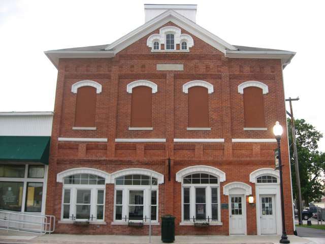
Photo: Nyttend, public domain · Wikimedia Commons
Local history sources: archive.org · villageofannaoh.com · en.wikipedia.org · en.wikipedia.org
Historic places
1 place in Anna on the National Register of Historic Places. Press a pin or a name for its whole record.
-
Anna Town HallBuilding · Anna · listed 1978
- Address
- Main St.
- Where
- Anna, Shelby County · ZIP 45302
- What it is
- Building
- Listed on the National Register
- 1978
- NRIS reference number
- 78002187
- Coordinates
- 40.39497, -84.17575
National Register file (NPS) ↗ Search Wikipedia ↗ Street map and directions ↗ On the Cracked Buckeye map
Source: National Park Service, National Register of Historic Places point file. The listing year is shown where NPS's certification date agrees with the listing's reference number. Listing recognizes significance; it does not restrict a private owner.
Water
Mostly private wells The water here
- Anna Village81% of residentsGroundwater wells (3 wells)
- Mccartyville Well Association16% of residentsGroundwater wells (2 wells)
- Kettlersville Well Association3% of residentsGroundwater wells (2 wells)
Hospitals, fire stations and more
Inside Anna's boundary: 1 fire or EMS station, 3 public schools, 1 library, 1 police station and 2 spill cases. Press a pin or a name for its whole record and its source.
Fire and EMS stations (1)
-
Anna Fire DepartmentAnna
- Address
- 515 South Pike Street, Anna, OH 45302
- Coordinates
- 40.38886, -84.17310
USGS National Map structures (source) ↗ Street map and directions ↗
Source: USGS National Map structures (most Ohio records last updated 2019 to 2022), checked against the Columbus and Cleveland station lists. The department that answers a call is set by jurisdiction and mutual aid, not by distance.
Public schools (3)
-
Anna Elementary School5 of 5 stars · Anna
- Address
- 607 N Pike St, Anna, OH 45302
- School district
- Anna Local School District
- Kind (NCES)
- Regular School
- Students, 2023-24
- 521
- Teachers (full-time equivalent)
- 30
- Report card, 2025-26
- 5 of 5 stars
- Performance index
- 95.1%
- Ohio building IRN
- 000745
- NCES school ID
- 391000403682
NCES school record ↗ Ohio School Report Card ↗ Street map and directions ↗
-
Anna High School5 of 5 stars · Anna
- Address
- 1 McRill Way, Anna, OH 45302
- School district
- Anna Local School District
- Kind (NCES)
- Regular School
- Students, 2023-24
- 301
- Teachers (full-time equivalent)
- 20.22
- Report card, 2025-26
- 5 of 5 stars
- Performance index
- 89.3%
- Four-year graduation rate
- 96.8%
- Ohio building IRN
- 000752
- NCES school ID
- 391000403683
NCES school record ↗ Ohio School Report Card ↗ Street map and directions ↗
-
Anna Middle School4 of 5 stars · Anna
- Address
- 1 McRill Way, Anna, OH 45302
- School district
- Anna Local School District
- Kind (NCES)
- Regular School
- Students, 2023-24
- 260
- Teachers (full-time equivalent)
- 11
- Report card, 2025-26
- 4 of 5 stars
- Performance index
- 89%
- Ohio building IRN
- 142331
- NCES school ID
- 391000404661
NCES school record ↗ Ohio School Report Card ↗ Street map and directions ↗
Source: NCES EDGE public school locations 2024-25 and Common Core of Data 2023-24 (type, students, teachers); Ohio School Report Cards 2025-26 (Department of Education and Workforce), matched by name within the district.
Public libraries (1)
-
Anna Community Branch LibraryBranch · Anna
- Address
- 304 N Second St, Anna, OH 45302
- What it is
- Branch
- Library system
- Shelby County Libraries - Amos Memorial
- Open
- 1,248 hours a year, 52 weeks
- Building
- 4,200 sq ft
- System's visits, FY2024
- 174,720
- System's loans, FY2024
- 201,964
- People the system serves
- 48,230
- Phone
- (937) 394-2761
IMLS Public Libraries Survey (source) ↗ Street map and directions ↗
Source: IMLS Public Libraries Survey FY2024 (outlets and their systems). Any Ohio resident can get a free card at any Ohio public library.
Police stations (1)
-
Anna Police DepartmentAnna
- Address
- 207 West Main Street, Anna, OH 45302
- Coordinates
- 40.39501, -84.17583
USGS National Map structures (source) ↗ Street map and directions ↗
Source: USGS National Map structures, police stations, corrected and completed by hand (September 2026). The department that answers a call is set by jurisdiction, not by distance.
Spills reported since 2021 (2)
-
Foam2026-08-19 · Anna
- Reported
- 2026-08-19
- What spilled
- Foam
- Where
- Anna, Shelby County
- Ohio EPA district office
- SWDO
- Ohio EPA case number
- 2608EPA0001545
Ohio EPA spill reports (source) ↗ Street map and directions ↗
-
Sheen Rainbow / Hydrocarbon2026-08-04 · Anna
- Reported
- 2026-08-04
- What spilled
- Sheen Rainbow / Hydrocarbon
- Where
- Anna, Shelby County
- Ohio EPA district office
- SWDO
- Ohio EPA case number
- 2608EPA0001419
Ohio EPA spill reports (source) ↗ Street map and directions ↗
Source: Ohio EPA emergency response spill reports, 2021 to September 2026, one point per case where Ohio EPA placed it. A report is what the caller or responder recorded; amounts are often blank or estimated.
Its ZIP codes
Each ZIP code that touches Anna, with the share of its residents who live here and the same headline figures as the ZIP page.
| ZIP | Share | Water | Radon | Home value | Schools | Flood |
|---|---|---|---|---|---|---|
| 45302 Anna | 33% | Mostly private wells | 4.6 pCi/L average radon | Median year built 1981 | Anna Local · 5 stars overall | 5.0% of residents in the 1% floodplain |
Local government
Who holds office in Anna, how its elections and ballot issues came out, and the state auditor's record.
Ballot issues
| Date | Issue | For | Against | Result |
|---|---|---|---|---|
| 2020-03-17 | Issue: Local Option - Anna Marathon (1) 17 Anna Village | 166 | 78 | Passed (68.03% for) |
| 2020-03-17 | Issue: Local Option - Anna Marathon (2) 17 Anna Village | 169 | 74 | Passed (69.55% for) |
Elections for office
| Date | Office | Candidates and votes |
|---|---|---|
| 2023-11-07 | Member of Council | Ken Aselage 382, 52.98%; Kristin Johnson 339, 47.02% |
| 2023-11-07 | Mayor | Cindy A. Naseman 475, 100.0% |
| 2019-11-05 | Member of Council (unofficial count) | Laura Lentz-Fogt 207, 100.0% |
| 2019-11-05 | Mayor (unofficial count) | Mark Pulfer 216, 100.0% |
Winners in bold. Results from the county board of elections' official canvass unless marked.
Auditor of State record
- No fiscal caution, watch or emergency on the Auditor of State's lists.
- Agreed Upon Procedures, 2023 to 2024, released 2025-10-09
The county
Shelby County: 11 ZIP codes, 21 cities, villages and townships, 45,735 people.
Nearby places
Rain and snow
How much has actually fallen on Anna, day by day, from 1893 to now. Daily totals, not averages.
- rain, last 30 days
- 1.00 in
- 2026-09-30 to 2026-10-29
- rain so far in 2026
- 42.8 in
- 7.6 in above normal for the date
- snow so far in 2026
- 18.8 in
- a normal year brings 19.6 in
- a normal year
- 41.5 in
- average of 30 years, 1991-2020
| Month | Rain (in) | Snow (in) | Days counted |
|---|---|---|---|
| October 2026 | 1.00 | — | 29 |
| September 2026 | 6.81 | — | 30 |
| August 2026 | 10.72 | — | 31 |
| July 2026 | 2.96 | — | 31 |
| June 2026 | 3.50 | — | 30 |
| May 2026 | 6.11 | — | 31 |
| April 2026 | 3.95 | — | 30 |
| March 2026 | 5.41 | 1.4 | 31 |
| February 2026 | 0.84 | 4.5 | 28 |
| January 2026 | 1.51 | 12.8 | 31 |
| December 2025 | 1.93 | 9.5 | 31 |
| November 2025 | 1.78 | 4.3 | 30 |
| Wettest year | 2011 — 58.6 in |
|---|---|
| Driest year | 1934 — 23.9 in |
| Snowiest year | 1910 — 53.4 in |
| Wettest day on record | 13 July 1992 — 3.98 in |
| Heaviest snowfall in a day | 26 November 1950 — 18.03 in |
| Deepest snow on the ground | 2 March 1912 — 37.99 in |
Estimated, not measured. No rain gauge has ever stood inside Anna, so every figure here is worked out from the gauges around it - the nearest ones weighted most. Treat them as close estimates rather than readings.
48,862 days of records, 1893-01-01 to 2026-10-29. Source: NOAA NCEI GHCN-Daily, 3,240 gauges in and around Ohio. A day is "gauged" when a gauge standing inside the boundary reported it, and the value is the mean of those gauges. Otherwise it is interpolated by inverse distance from every gauge reporting within 50 miles. Nothing is carried forward, back-filled or smoothed. Against NOAA nClimDiv county monthly precipitation over 136,848 complete county-months (checked 2026-10-31): correlation 0.9515, median absolute difference 0.217 in a month. Built 2026-10-31 from the Cracked Buckeye precipitation archive. Snow is the softer number — snowfall is measured by hand with a ruler, no agency publishes a gridded county snowfall series, and blowing snow defeats every observer.
Environmental permits and filings
What Ohio EPA has on file for Anna: permits, inspections, violations, cleanups and the state loans behind sewer and water work. Every line links to the agency's own document.
- facilities and sites on file
- 4
- those placed on the map inside Anna
| Program | Facilities and sites |
|---|---|
| Wastewater and stormwater discharge | 2 |
| Public drinking water | 1 |
| Sewer and water-line construction | 1 |
| Date | Facility or site | What |
|---|---|---|
| ANNA PWS | Public drinking water compliance letter | |
| ANNA PWS | Public drinking water notice of violation | |
| ANNA PWS | Public drinking water notice of violation | |
| ANNA PWS | Public drinking water report | |
| ANNA PWS | Public drinking water plan | |
| ANNA VILLAGE | Public drinking water notice of violation | |
| ANNA PWS | Public drinking water plan | |
| DEERBROOK SUBDIVISION | Sewer and water-line construction permit | |
| DEERBROOK SUBDIVISION | Sewer and water-line construction permit | |
| ANNA PWS | Public drinking water inspection | |
| ANNA PWS | Public drinking water notice of violation | |
| ANNA PWS | Public drinking water notice of violation | |
| ANNA PWS | Public drinking water plan | |
| DEERBROOK SUBDIVISION | Sewer and water-line construction permit | |
| ANNA PWS | Public drinking water compliance letter | |
| WELLS BROTHERS SITE | Wastewater and stormwater discharge violation resolved | |
| ANNA PWS | Public drinking water report | |
| WELLS BROTHERS SITE | Wastewater and stormwater discharge notice of violation | |
| ANNA INDUSTRIAL PARK | Wastewater and stormwater discharge permit | |
| ANNA PWS | Public drinking water compliance letter | |
| ANNA PWS | Public drinking water notice of violation | |
| WELLS BROTHERS SITE | Wastewater and stormwater discharge permit | |
| ANNA PWS | Public drinking water compliance letter | |
| ANNA PWS | Public drinking water report | |
| ANNA PWS | Public drinking water notice of violation |
Source: Ohio EPA eDocument portal (edocpub.epa.ohio.gov), indexed 2026-10-14. Facilities are placed on the map from Ohio EPA's own map layers, EPA's Facility Registry, coordinates written in the filings, or a geocoded street address. A permit filed under a private person's name (most are household septic systems) is counted but never named, placed or linked; licenses for individual workers and open-burning notices are left out entirely.
Quick answers
What county is Anna, Ohio in?
Anna is a village in Shelby County, Ohio, with 1,443 residents.
When was Anna, Ohio founded?
Anna was settled 1833 (John W. Carey, Josiah Greene, John Munch); laid out 1858 (Carey's Station, by J. W. Carey); surveyed 1867 by John L. and Fletcher Thirkield (Wikipedia: platted 1868); incorporated June 26, 1877. Founders on record: J. W. Carey; surveyed by John and Fletcher Thirkield. Source
How did Anna, Ohio get its name?
Renamed from Carey's Station to Anna in the 1860s, in honor of J. Source
What ZIP code is Anna, Ohio?
Most of Anna is in ZIP code 45302.
Where does Anna, Ohio get its water?
The main water source for Anna (Anna Village): Mostly private wells.
Cite this page
Cite this page as:
Cracked Buckeye, "Anna, Shelby County", https://crackedbuckeye.com/place/anna/, built 2026-10-31, accessed [date].
How to cite · Report a correction · Built 2026-10-31
