Local events in Clarksville
Nothing is posted for Clarksville itself yet; here is what is on within 10 miles. All local events in Clarksville
Know a calendar we should watch? Send the link
Checked October 20; the events page is refreshed daily.
Lakes near Clarksville
The history under the water: the valley before, the dam, the stories. All Ohio lakes
How Clarksville began
Clarksville was established in 1816 and took its name from Sarah Clark Hadley, wife of an early settler. The small village on Ohio State Route 350 in Clinton County grew slowly, peaking near 583 residents around 1960, and stood at 534 in the 2020 census. It draws water from Western Water Company, a rural non-profit system founded in 1976 that also serves parts of Brown, Clermont and Warren counties, and has been navigating a multi-year PFAS treatment upgrade funded by USDA Rural Development.
Platted 1816.
Where the name comes from
Named for Sarah Clark Hadley, wife of an early settler in the area.
Before the town
No site-specific Native American record was found for Clarksville village itself. It sits in southeastern Clinton County within the Virginia Military District, land ceded by the 1795 Treaty of Greenville and historically used by the Shawnee. Clinton County holds county-wide Adena, Hopewell and historic-nation evidence, but nothing tied to a named village, trail, mound or earthwork inside the village's own small footprint (0.49 square miles) was found.
Nations recorded here: Shawnee.
Timeline
- — Clarksville established, named for Sarah Clark Hadley.
- — Village population recorded at 389.
- — Village population peaked at about 583 before declining through the 1980s-90s and later stabilizing.
- — Western Water Company founded as a non-profit, customer-owned rural water system serving Brown, Clermont, Clinton and Warren counties, with USDA financing.
- — USDA Rural Development obligated a $7.5 million Water and Waste Disposal loan to expand Western Water's Morrow treatment plant for PFAS removal.
- — USDA and company officials celebrated the loan in Morrow; the treatment-plant expansion was scheduled to begin in 2025 and finish in 2026.
Stories
A sculptor's farmhouse just outside the village line
A mile or so north of Clarksville on the old Wilmington-Lebanon Pike stands the Eli Harvey House at 1133 Lebanon Road, an early-1800s farmhouse tied to one of southwestern Ohio's many original Quaker farms. Eli Harvey (1803-1872) came to the area as a child with his family from North Carolina around 1806-1807, married Sarah Fallis in 1824, bought part of his father's land, and built his household on the newly laid-out pike. The house was listed on the National Register of Historic Places on February 14, 1978, recognized for its ties to art, settlement, religion, and social history spanning 1825 to 1899. Though it carries Clarksville's ZIP code and is described locally as its own landmark, the house sits outside the village's platted limits, in the surrounding farmland rather than inside Clarksville itself.
Photographs
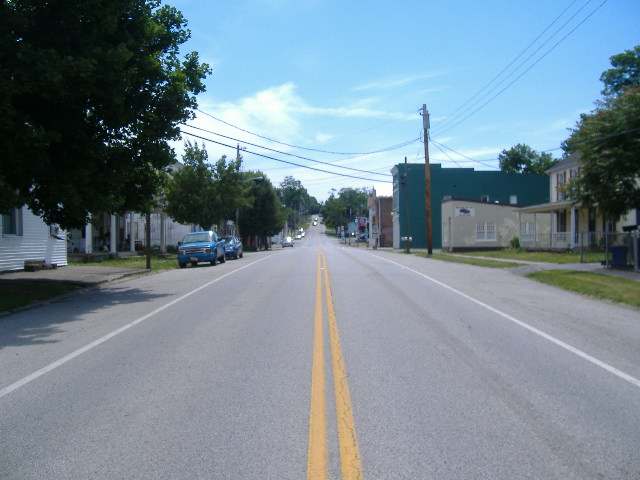
Photo: Aesopposea, CC BY-SA 3.0 · Wikimedia Commons
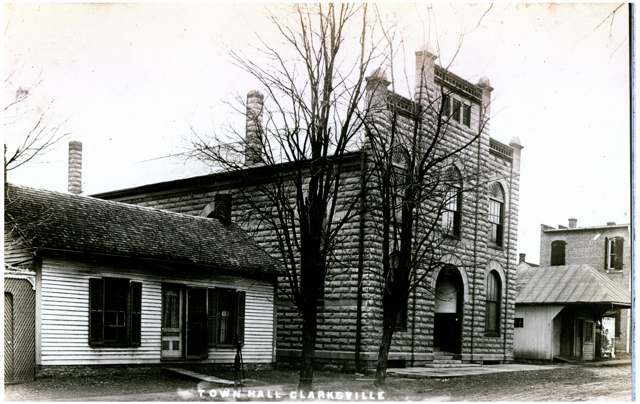
Photo: Digital Public Library of America / Wikimedia Commons, public domain · Wikimedia Commons
Local history sources: en.wikipedia.org · drive.quakerscenicbywayohio.org · npgallery.nps.gov · en.wikipedia.org · web.archive.org
Water
Ohio River intake at the plant's riverfront on Kellogg Ave in the California neighborhood, east Cincinnati The water here
- Western Water Company83% of residentsLittle Miami River valley wells (51%) plus Cincinnati Ohio River water (49%)
- Clarksville Village17% of residentsOhio River (Miller Plant, ~88%) plus Great Miami Buried Valley Aquifer wells (~12%)
Hospitals, fire stations and more
Inside Clarksville's boundary: 1 fire or EMS station. Press a pin or a name for its whole record and its source.
Fire and EMS stations (1)
-
Clinton - Warren Joint Fire and RescueClarksville
- Address
- 82 Spring Hill Road, Clarksville, OH 45113
- Coordinates
- 39.40393, -83.98671
USGS National Map structures (source) ↗ Street map and directions ↗
Source: USGS National Map structures (most Ohio records last updated 2019 to 2022), checked against the Columbus and Cleveland station lists. The department that answers a call is set by jurisdiction and mutual aid, not by distance.
Its ZIP codes
Each ZIP code that touches Clarksville, with the share of its residents who live here and the same headline figures as the ZIP page.
| ZIP | Share | Water | Radon | Home value | Schools | Flood |
|---|---|---|---|---|---|---|
| 45113 Vernon Township and Clarksville | 13% | Ohio River intake at the plant's riverfront on Kellogg Ave in the California neighborhood, east Cincinnati | 4.6 pCi/L average radon | Median year built 1990 | Clinton-Massie Local · 4.5 stars overall | 6.5% of residents in the 1% floodplain |
Local government
Who holds office in Clarksville, how its elections and ballot issues came out, and the state auditor's record.
Elections for office
| Date | Office | Candidates and votes |
|---|---|---|
| 2021-11-02 | Member of Council | Aaron Carter 29, 35.37%; Eric Rogers 27, 32.93%; William H. Pence 26, 31.71% |
Winners in bold. Results from the county board of elections' official canvass unless marked.
Auditor of State record
- Fiscal emergency: declared 2015-09-15, still in effect. source
The county
Clinton County: 9 ZIP codes, 21 cities, villages and townships, 47,594 people.
Nearby places
Rain and snow
How much has actually fallen on Clarksville, day by day, from 1893 to now. Daily totals, not averages.
- rain, last 30 days
- 0.79 in
- 2026-09-30 to 2026-10-29
- rain so far in 2026
- 45.6 in
- 7.5 in above normal for the date
- snow so far in 2026
- 18.4 in
- a normal year brings 23.1 in
- a normal year
- 44.9 in
- average of 30 years, 1991-2020
| Month | Rain (in) | Snow (in) | Days counted |
|---|---|---|---|
| October 2026 | 0.79 | — | 29 |
| September 2026 | 6.69 | — | 30 |
| August 2026 | 7.50 | — | 31 |
| July 2026 | 4.35 | — | 31 |
| June 2026 | 5.21 | — | 30 |
| May 2026 | 6.04 | — | 31 |
| April 2026 | 4.06 | — | 30 |
| March 2026 | 8.01 | 1.0 | 31 |
| February 2026 | 1.43 | 5.9 | 28 |
| January 2026 | 1.56 | 11.5 | 31 |
| December 2025 | 2.82 | 11.5 | 31 |
| November 2025 | 3.75 | 4.2 | 30 |
| Wettest year | 1929 — 60.7 in |
|---|---|
| Driest year | 1930 — 25.6 in |
| Snowiest year | 1951 — 50.0 in |
| Wettest day on record | 6 October 1910 — 5.69 in |
| Heaviest snowfall in a day | 26 November 1950 — 10.38 in |
| Deepest snow on the ground | 27 February 1905 — 23.79 in |
Estimated, not measured. No rain gauge has ever stood inside Clarksville, so every figure here is worked out from the gauges around it - the nearest ones weighted most. Treat them as close estimates rather than readings.
48,874 days of records, 1893-01-01 to 2026-10-29. Source: NOAA NCEI GHCN-Daily, 3,240 gauges in and around Ohio. A day is "gauged" when a gauge standing inside the boundary reported it, and the value is the mean of those gauges. Otherwise it is interpolated by inverse distance from every gauge reporting within 50 miles. Nothing is carried forward, back-filled or smoothed. Against NOAA nClimDiv county monthly precipitation over 136,848 complete county-months (checked 2026-10-31): correlation 0.9515, median absolute difference 0.217 in a month. Built 2026-10-31 from the Cracked Buckeye precipitation archive. Snow is the softer number — snowfall is measured by hand with a ruler, no agency publishes a gridded county snowfall series, and blowing snow defeats every observer.
Environmental permits and filings
What Ohio EPA has on file for Clarksville: permits, inspections, violations, cleanups and the state loans behind sewer and water work. Every line links to the agency's own document.
- facilities and sites on file
- 2
- those placed on the map inside Clarksville
| Program | Facilities and sites |
|---|---|
| Hazardous waste | 1 |
| Site assessment | 1 |
Source: Ohio EPA eDocument portal (edocpub.epa.ohio.gov), indexed 2026-10-14. Facilities are placed on the map from Ohio EPA's own map layers, EPA's Facility Registry, coordinates written in the filings, or a geocoded street address. A permit filed under a private person's name (most are household septic systems) is counted but never named, placed or linked; licenses for individual workers and open-burning notices are left out entirely.
Quick answers
What county is Clarksville, Ohio in?
Clarksville is a village in Clinton County, Ohio, with 534 residents.
When was Clarksville, Ohio founded?
Clarksville was laid out 1816. Source
How did Clarksville, Ohio get its name?
Named for Sarah Clark Hadley, wife of an early settler in the area. Source
What ZIP code is Clarksville, Ohio?
Most of Clarksville is in ZIP code 45113.
Where does Clarksville, Ohio get its water?
The main water source for Clarksville (Western Water Company): Ohio River intake at the plant's riverfront on Kellogg Ave in the California neighborhood, east Cincinnati.
Cite this page
Cite this page as:
Cracked Buckeye, "Clarksville, Clinton County", https://crackedbuckeye.com/place/clarksville/, built 2026-10-31, accessed [date].
How to cite · Report a correction · Built 2026-10-31
