Local events in Waterville
30 events in the next 90 days from 2 public calendars. All local events in Waterville
Checked October 20; the events page is refreshed daily.
How Waterville began
Waterville grew up on the west bank of the upper Maumee River at a spot traders and settlers called Pray's Falls, where French Canadian trader-turned-townsman John Pray built a black-walnut-beamed trading post and tavern in 1828 -- the building known today as the Columbian House -- two years before he formally platted the town in 1830. The site sat just downriver from Roche de Boeuf, a limestone outcrop in the Maumee that served Native leaders, including Little Turtle, Blue Jacket and Tarhe, as a council ground in the years before the 1794 Battle of Fallen Timbers, and that the 1908 Interurban Bridge later partly blasted away for a pier. Long a village, Waterville incorporated as a city in 2011, and its river-facing Third Street commercial district and the Columbian House both remain on the National Register of Historic Places.
Settled 1828, when John Pray built a trading post, tavern and hostel (later called the Columbian House) opposite Pray's Falls on the Maumee, platted 1830, by John Pray, on the west bank of the upper Maumee River, incorporated long a village; incorporated as a city in 2011, by John Pray.
Where the name comes from
A post office named Waterville had already opened in 1828, two years before John Pray's formal plat; the name reflects the town's position on the Maumee River at Pray's Falls, though no source consulted spells out who chose it or exactly why.
Before the town
Just north of Waterville, the limestone outcrop the French called Roche de Boeuf ('Rock of Beef,' for its buffalo-like profile) stood in the Maumee River as a council ground for Native leaders in the years before the Northwest Indian War; oral tradition names Little Turtle (Miami), Blue Jacket (Shawnee) and Tarhe (Wyandot) among those who met there to plan strategy against General Anthony Wayne's advancing army ahead of the August 1794 Battle of Fallen Timbers. Almost a third of the rock was later blasted away in 1908 to seat a pier of the Interurban Bridge, which still crosses the river at the spot and today carries the National Register listing. A few miles upriver, the Nawash-Kinjoano Reservation -- Odawa (Ottawa) villages on the Maumee's north bank named for the war chief Nawash, who had fought alongside Tecumseh in the War of 1812 -- ran from just west of Waterville east past Providence from 1807 until its 1831 dissolution, with a related Ottawa village, Tontongany, on the river's south side. The historical name 'Tondagamies Village,' which the federal place-name database (GNIS) records for this ZIP code, most plausibly reflects this same Tontongany/Nawash cluster of Ottawa river towns rather than a separate, unrelated place, though we do not treat that identification as certain.
Nations recorded here: Odawa (Ottawa), Miami, Shawnee, Wyandot.
- Roche de Boeuf (other) — in the Maumee River just north of Waterville, at the site of the 1908 Interurban Bridge, used as a council ground before 1794; partly destroyed 1908 (en.wikipedia.org)
- Nawash-Kinjoano Reservation (treaty) — Maumee River, north bank, from just west of Waterville east toward Providence, 1807 to 1831 (en.wikipedia.org)
Timeline
- — The Nawash-Kinjoano Reservation, Odawa villages on the Maumee's north bank near Waterville, is established and later dissolved by treaty.
- — Native leaders reportedly council at Roche de Boeuf, in the Maumee just north of the future Waterville, ahead of the Battle of Fallen Timbers.
- — John Pray builds a black-walnut-beamed trading post, tavern and hostel opposite Pray's Falls on the Maumee, the building later known as the Columbian House; a post office named Waterville opens the same year.
- — John Pray formally plats the town of Waterville on the Maumee's west bank.
- — Construction of the Interurban Bridge across the Maumee destroys nearly a third of the Roche de Boeuf outcrop to seat a bridge pier.
- — The National Park Service's Historic American Buildings Survey photographs and measures the Columbian House.
- — The Columbian House operates as a restaurant.
- — The Interurban Bridge is added to the National Register of Historic Places.
- — Waterville, long a village, incorporates as a city.
Stories
A rock that outlasted the councils held on it
Long before Waterville had a name, the limestone shelf French traders called Roche de Boeuf broke the surface of the Maumee River just north of the future town, prominent enough that Native leaders used it as a meeting ground in the last years before the United States pushed into the Ohio country in force. Local tradition holds that Little Turtle of the Miami, Blue Jacket of the Shawnee and Tarhe the Crane of the Wyandot were among the war leaders who gathered there to plan resistance to General Anthony Wayne's army ahead of the August 1794 Battle of Fallen Timbers, fought a few miles downriver. The rock survived the battle, the treaties, and more than a century of settlement, only to lose nearly a third of its mass in 1908, when builders of the Ohio Electric Railway's Interurban Bridge needed a pier foundation and found the outcrop convenient. The remaining rock and the century-old bridge above it are both still there, the bridge now valued as a historic structure in its own right even as its construction is what scarred the older landmark beneath it.
The trading post that became a restaurant and a landmark
In 1828, two years before he bothered to plat a town, John Pray put up a sturdy building of black walnut beams on the Maumee's west bank, opposite the rapids known as Pray's Falls, to serve as trading post, tavern and hostel for the traffic already moving along the river. Waterville grew up around it. Over the following century the same building -- eventually known as the Columbian House -- did service as a jail cell for prisoners in transit, a dressmaker's shop, and a doctor's office, expanding to three stories as its uses multiplied, before settling into a fifty-year run as a restaurant from 1943 to 1993. The National Park Service thought enough of the structure to send photographer Carl F. Waite to measure and photograph it for the Historic American Buildings Survey in April 1934, leaving a federal record of a building that had already, by then, outlived several of the purposes it was built for.
Photographs
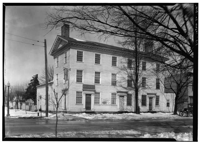
Photo: Carl F. Waite, National Park Service (Historic American Buildings Survey), public domain · Wikimedia Commons
Local history sources: en.wikipedia.org · en.wikipedia.org · en.wikipedia.org · commons.wikimedia.org
Historic places
7 places in Waterville on the National Register of Historic Places. Press a pin or a name for its whole record.
-
Columbian HouseBuilding · Waterville · listed 1969
- Address
- River and Farnsworth Rds.
- Where
- Waterville, Lucas County · ZIP 43566
- What it is
- Building
- Listed on the National Register
- 1969
- NRIS reference number
- 69000146
- Coordinates
- 41.49945, -83.71733
National Register file (NPS) ↗ Search Wikipedia ↗ Street map and directions ↗ On the Cracked Buckeye map
-
Gillett-Shoemaker-Welsh HouseBuilding · Waterville · listed 1975
- Address
- 133 N. 4th St.
- Where
- Waterville, Lucas County · ZIP 43566
- What it is
- Building
- Listed on the National Register
- 1975
- NRIS reference number
- 75001474
- Coordinates
- 41.50197, -83.72103
National Register file (NPS) ↗ Search Wikipedia ↗ Street map and directions ↗ On the Cracked Buckeye map
-
Haskins, Liberty Whitcomb, HouseBuilding · Waterville · listed 1975
- Address
- N of Waterville at 625 Canal Rd.
- Where
- Waterville, Lucas County · ZIP 43566
- What it is
- Building
- Listed on the National Register
- 1975
- NRIS reference number
- 75001475
- Coordinates
- 41.50940, -83.71942
National Register file (NPS) ↗ Search Wikipedia ↗ Street map and directions ↗ On the Cracked Buckeye map
-
Isham, John, HouseBuilding · Waterville · listed 1982
- Address
- 8460 S. River Rd.
- Where
- Waterville, Lucas County · ZIP 43566
- What it is
- Building
- Listed on the National Register
- 1982
- NRIS reference number
- 82005388
- Coordinates
- 41.48145, -83.75083
National Register file (NPS) ↗ Search Wikipedia ↗ Street map and directions ↗ On the Cracked Buckeye map
-
Morehouse-Downes HouseBuilding · Waterville · listed 1975
- Address
- 4 S. River Rd.
- Where
- Waterville, Lucas County · ZIP 43566
- What it is
- Building
- Listed on the National Register
- 1975
- NRIS reference number
- 75001476
- Coordinates
- 41.49899, -83.71755
National Register file (NPS) ↗ Search Wikipedia ↗ Street map and directions ↗ On the Cracked Buckeye map
-
Pray-Starkweather HouseBuilding · Waterville · listed 1975
- Address
- 144 N. River Rd.
- Where
- Waterville, Lucas County · ZIP 43566
- What it is
- Building
- Listed on the National Register
- 1975
- NRIS reference number
- 75001477
- Coordinates
- 41.50154, -83.71658
National Register file (NPS) ↗ Search Wikipedia ↗ Street map and directions ↗ On the Cracked Buckeye map
-
Waterville Commercial DistrictHistoric district · Waterville · listed 1976
- Address
- 3rd St.
- Where
- Waterville, Lucas County · ZIP 43566
- What it is
- Historic district
- Listed on the National Register
- 1976
- NRIS reference number
- 76001477
- Coordinates
- 41.49984, -83.71986
National Register file (NPS) ↗ Search Wikipedia ↗ Street map and directions ↗ On the Cracked Buckeye map
Source: National Park Service, National Register of Historic Places point file. The listing year is shown where NPS's certification date agrees with the listing's reference number. Listing recognizes significance; it does not restrict a private owner.
Water
Maumee River, pumped from a riverside intake on Ohio 65 into the 170-million-gallon Bowling Green Reservoir for storage before treatment The water here
- Waterville City88% of residentsMaumee River (via Bowling Green Reservoir)
- Toledo City Of12% of residentsLake Erie
Hospitals, fire stations and more
Inside Waterville's boundary: 2 nursing homes, 2 fire and EMS stations, 1 public school, 1 private school, 1 library, 2 museums, 2 police stations, 1 Superfund site, 1 Toxics Release Inventory facility and 3 spill cases. Press a pin or a name for its whole record and its source.
Nursing homes (2)
-
Astoria Place of Waterville Abuse citation2 of 5 stars · Waterville
- Address
- 555 Anthony Wayne Trail, Waterville, OH 43566
- Certified beds
- 90
- Residents on an average day
- 63
- Medicare overall rating
- 2 of 5 stars
- Health inspections
- 1 of 5 stars
- Staffing
- 1 of 5 stars
- Quality measures
- 5 of 5 stars
- Penalties since 2023
- 4 fines totalling $350,464, 1 payment denial (latest 2026-01-08)
- Abuse citation (CMS icon)
- Yes
- Ownership
- For profit - Corporation
- Chain
- CERTUS HEALTHCARE
- Takes
- Medicare and Medicaid
- Phone
- (419) 878-3901
- Medicare ID
- 365747
Medicare Care Compare ↗ CMS nursing home data (source) ↗ Street map and directions ↗
-
Ayden Healthcare of Waterville2 of 5 stars · Waterville
- Address
- 8885 Browning Drive, Waterville, OH 43566
- Certified beds
- 99
- Residents on an average day
- 75
- Medicare overall rating
- 2 of 5 stars
- Health inspections
- 1 of 5 stars
- Staffing
- 2 of 5 stars
- Quality measures
- 5 of 5 stars
- Penalties since 2023
- 1 fine totalling $75,286 (latest 2023-08-25)
- Ownership
- For profit - Limited Liability company
- Chain
- AYDEN HEALTHCARE
- Takes
- Medicare and Medicaid
- Phone
- (419) 878-8523
- Medicare ID
- 365617
Medicare Care Compare ↗ CMS nursing home data (source) ↗ Street map and directions ↗
Source: CMS Care Compare nursing home provider and penalties files; Medicare star ratings run 1 to 5.
Fire and EMS stations (2)
-
Waterville Fire DepartmentWaterville
- Address
- 751 Waterville Monclova Road, Waterville, OH 43566
- Coordinates
- 41.51271, -83.73741
USGS National Map structures (source) ↗ Street map and directions ↗
-
Waterville Fire DepartmentWaterville
- Address
- 808 Michigan Avenue, Waterville, OH 43566
- Coordinates
- 41.50093, -83.72602
USGS National Map structures (source) ↗ Street map and directions ↗
Source: USGS National Map structures (most Ohio records last updated 2019 to 2022), checked against the Columbus and Cleveland station lists. The department that answers a call is set by jurisdiction and mutual aid, not by distance.
Public schools (1)
-
Waterville Primary School5 of 5 stars · Waterville
- Address
- 457 Sycamore Ln, Waterville, OH 43566
- School district
- Anthony Wayne Local School District
- Kind (NCES)
- Regular School
- Students, 2023-24
- 490
- Teachers (full-time equivalent)
- 28
- Report card, 2025-26
- 5 of 5 stars
- Performance index
- 98%
- Ohio building IRN
- 039800
- NCES school ID
- 390482003147
NCES school record ↗ Ohio School Report Card ↗ Street map and directions ↗
Source: NCES EDGE public school locations 2024-25 and Common Core of Data 2023-24 (type, students, teachers); Ohio School Report Cards 2025-26 (Department of Education and Workforce), matched by name within the district.
Private schools (1)
-
Discovery CenterPrivate, religious, independent · Waterville
- Address
- 8011 Dutch Rd, Waterville, OH 43566
- Kind
- religious, independent
- Students, 2023-24
- 35
- Teachers (full-time equivalent)
- 2.1
- Students per teacher
- 16.6667
- Phone
- (419) 878-8689
- NCES private school ID
- A1502843
Source: NCES Private School Survey 2023-24.
Public libraries (1)
-
Waterville BranchBranch · Waterville
- Address
- 800 Michigan Avenue, Waterville, OH 43566
- What it is
- Branch
- Library system
- Toledo-Lucas County Public Library
- Open
- 3,276 hours a year, 52 weeks
- Building
- 11,618 sq ft
- System's visits, FY2024
- 2,028,520
- System's loans, FY2024
- 4,940,529
- People the system serves
- 428,505
- Phone
- (419) 878-3055
IMLS Public Libraries Survey (source) ↗ Street map and directions ↗
Source: IMLS Public Libraries Survey FY2024 (outlets and their systems). Any Ohio resident can get a free card at any Ohio public library.
Museums, historical societies, gardens and zoos (2)
-
Toledo Lake Erie & Western RailwayHistorical society · Waterville
- What it is
- Historical society
- City
- Waterville
- Coordinates
- 41.50343, -83.73519
Search Wikipedia ↗ IMLS Museum Data Files (source) ↗ Street map and directions ↗
The museum list is IMLS's 2018 file; a museum may have closed or moved since.
-
Waterville Historical SocietyHistorical society · Waterville
- What it is
- Historical society
- City
- Waterville
- Coordinates
- 41.50343, -83.73519
Search Wikipedia ↗ IMLS Museum Data Files (source) ↗ Street map and directions ↗
The museum list is IMLS's 2018 file; a museum may have closed or moved since.
Source: IMLS Museum Data Files, 2018.
Police stations (2)
-
Waterville Police DepartmentWaterville
- Address
- 25 North 2nd Street, Waterville, OH 43566
- Coordinates
- 41.49995, -83.71874
USGS National Map structures (source) ↗ Street map and directions ↗
-
Waterville Township Police DepartmentWaterville
- Address
- 8245 Farnsworth Road Suite C, Waterville, OH 43566
- Coordinates
- 41.49772, -83.73974
USGS National Map structures (source) ↗ Street map and directions ↗
Source: USGS National Map structures, police stations, corrected and completed by hand (September 2026). The department that answers a call is set by jurisdiction, not by distance.
Superfund sites (1)
-
Waterville MercurySuperfund program · Waterville
- Address
- N. Fifth Street, Waterville, OH 43566
- County
- Lucas County
- Status
- Superfund program site, not on the National Priorities List
- EPA program ID
- OHN000510432
- EPA registry ID
- 110040752487
EPA facility record ↗ EPA Facility Registry Service (source) ↗ Street map and directions ↗
Source: EPA Facility Registry Service, Superfund (SEMS) and National Priorities List sites. Many program sites were assessed and needed no cleanup.
Facilities reporting toxic releases (1)
-
Rimer Enterprises IncToxics Release Inventory · Waterville
- Address
- 916 Rimer Dr, Waterville, OH 43566
- County
- Lucas County
- Status
- Reports to the Toxics Release Inventory (active)
- EPA program ID
- 43566RMRNT916MA
- EPA registry ID
- 110000383889
EPA facility record ↗ EPA Facility Registry Service (source) ↗ Street map and directions ↗
Source: EPA Facility Registry Service, Toxics Release Inventory reporters. Reporting a release is required of large users of listed chemicals; it is not by itself a violation.
Spills reported since 2021 (3)
-
Fuel Gasoline ( 25% Ethanol Not E85)2022-07-13 · Waterville Twp
- Reported
- 2022-07-13
- What spilled
- Fuel Gasoline ( 25% Ethanol Not E85)
- Where
- Waterville Twp, Lucas County
- Ohio EPA district office
- NWDO
- Ohio EPA case number
- 2207EPA0001058
Ohio EPA spill reports (source) ↗ Street map and directions ↗
-
Fuel Diesel / Diesel Fuel (Vehicle On Or Off Road)2021-08-24 · Waterville
- Reported
- 2021-08-24
- What spilled
- Fuel Diesel / Diesel Fuel (Vehicle On Or Off Road)
- Largest amount reported
- 15 gallons
- Where
- Waterville, Lucas County
- Ohio EPA district office
- NWDO
- Ohio EPA case number
- 2108EPA0001327
Ohio EPA spill reports (source) ↗ Street map and directions ↗
-
Fuel Gasoline ( 25% Ethanol Not E85) Reached water2026-05-07 · Waterville
- Reported
- 2026-05-07
- What spilled
- Fuel Gasoline ( 25% Ethanol Not E85); Coolant; Oil Hydraulic Fluid(S)
- Largest amount reported
- 2 gallons
- Reached a waterway
- 99 - Unnamed
- Where
- Waterville, Lucas County
- Ohio EPA district office
- NWDO
- Ohio EPA case number
- 2605EPA0000768
Ohio EPA spill reports (source) ↗ Street map and directions ↗
Source: Ohio EPA emergency response spill reports, 2021 to September 2026, one point per case where Ohio EPA placed it. A report is what the caller or responder recorded; amounts are often blank or estimated.
Its ZIP codes
Each ZIP code that touches Waterville, with the share of its residents who live here and the same headline figures as the ZIP page.
| ZIP | Share | Water | Radon | Home value | Schools | Flood |
|---|---|---|---|---|---|---|
| 43566 Waterville | 72% | Maumee River, pumped from a riverside intake on Ohio 65 into the 170-million-gallon Bowling Green Reservoir for storage before treatment | 5.6 pCi/L average radon | Median year built 1982 | Anthony Wayne Local · 4.5 stars overall | 4.0% of residents in the 1% floodplain |
Local government
Who holds office in Waterville, how its elections and ballot issues came out, and the state auditor's record.
Auditor of State record
- No fiscal caution, watch or emergency on the Auditor of State's lists.
- Financial Health Indicators (the Auditor of State's 17 measures; critical / cautionary / positive): 2020 0 / 2 / 15; 2021 0 / 1 / 16; 2022 0 / 1 / 16; 2023 0 / 1 / 16; 2024 0 / 3 / 14; 2025 0 / 2 / 14.
- Financial Audit, 2024, released 2026-01-22
- Financial Audit, 2023, released 2024-12-26
The county
Lucas County: 26 ZIP codes, 20 cities, villages and townships, 427,372 people.
Nearby places
Rain and snow
How much has actually fallen on Waterville, day by day, from 1871 to now. Daily totals, not averages.
- rain, last 30 days
- 2.16 in
- 2026-09-29 to 2026-10-28
- rain so far in 2026
- 33.6 in
- 3.4 in above normal for the date
- snow so far in 2026
- 17.0 in
- a normal year brings 31.0 in
- a normal year
- 35.4 in
- average of 30 years, 1991-2020
| Month | Rain (in) | Snow (in) | Days counted |
|---|---|---|---|
| October 2026 | 2.16 | — | 28 |
| September 2026 | 2.90 | — | 30 |
| August 2026 | 4.88 | — | 31 |
| July 2026 | 3.81 | — | 31 |
| June 2026 | 4.20 | — | 30 |
| May 2026 | 2.37 | — | 31 |
| April 2026 | 6.81 | — | 30 |
| March 2026 | 4.53 | 0.0 | 31 |
| February 2026 | 0.69 | 2.7 | 28 |
| January 2026 | 1.22 | 14.2 | 31 |
| December 2025 | 1.64 | 6.9 | 31 |
| November 2025 | 1.79 | 5.0 | 30 |
| Wettest year | 1950 — 50.7 in |
|---|---|
| Driest year | 1963 — 21.3 in |
| Snowiest year | 2014 — 76.2 in |
| Wettest day on record | 4 September 1918 — 3.40 in |
| Heaviest snowfall in a day | 28 February 1900 — 13.88 in |
| Deepest snow on the ground | 6 February 1978 — 18.59 in |
Estimated, not measured. No rain gauge has ever stood inside Waterville, so every figure here is worked out from the gauges around it - the nearest ones weighted most. Treat them as close estimates rather than readings.
56,914 days of records, 1871-01-01 to 2026-10-28. Source: NOAA NCEI GHCN-Daily, 3,240 gauges in and around Ohio. A day is "gauged" when a gauge standing inside the boundary reported it, and the value is the mean of those gauges. Otherwise it is interpolated by inverse distance from every gauge reporting within 50 miles. Nothing is carried forward, back-filled or smoothed. Against NOAA nClimDiv county monthly precipitation over 136,848 complete county-months (checked 2026-10-31): correlation 0.9515, median absolute difference 0.217 in a month. Built 2026-10-31 from the Cracked Buckeye precipitation archive. Snow is the softer number — snowfall is measured by hand with a ruler, no agency publishes a gridded county snowfall series, and blowing snow defeats every observer.
Environmental permits and filings
What Ohio EPA has on file for Waterville: permits, inspections, violations, cleanups and the state loans behind sewer and water work. Every line links to the agency's own document.
- facilities and sites on file
- 23
- those placed on the map inside Waterville
| Program | Facilities and sites |
|---|---|
| Wastewater and stormwater discharge | 12 |
| Hazardous waste | 5 |
| Air pollution | 3 |
| Public drinking water | 1 |
| Sewer and water-line construction | 1 |
| State sewer loans | 1 |
| Date | Facility or site | What |
|---|---|---|
| WATERVILLE, CITY OF PWS | Public drinking water compliance letter | |
| FARNSWORTH VILLAGE AT WATERVILLE LANDING PLAT 7 | Wastewater and stormwater discharge inspection | |
| STONEFIELD VILLAGE AT WATERVILLE LANDINGS PLAT ONE | Wastewater and stormwater discharge inspection | |
| WATERVILLE, CITY OF PWS | Public drinking water warning letter | |
| WATERVILLE, CITY OF PWS | Public drinking water violation resolved | |
| WATERVILLE, CITY OF PWS | Public drinking water plan | |
| STONEFIELD VILLAGE AT WATERVILLE LANDINGS PLAT ONE | Sewer and water-line construction permit | |
| STONEFIELD VILLAGE AT WATERVILLE LANDINGS PLAT ONE | Sewer and water-line construction permit | |
| STONEFIELD VILLAGE AT WATERVILLE LANDINGS PLAT ONE | Wastewater and stormwater discharge permit | |
| WATERVILLE, CITY OF PWS | Public drinking water plan | |
| STONEFIELD VILLAGE AT WATERVILLE LANDINGS PLAT ONE | Sewer and water-line construction permit | |
| WATERVILLE, CITY OF PWS | Public drinking water notice of violation | |
| WATERVILLE, CITY OF PWS | Public drinking water notice of violation | |
| WATERVILLE, CITY OF PWS | Public drinking water plan | |
| WATERVILLE, CITY OF PWS | Public drinking water inspection | |
| WATERVILLE-MONCLOVA ROAD IMPROVEMENT | Wastewater and stormwater discharge permit | |
| WATERVILLE, CITY OF PWS | Public drinking water inspection | |
| WATERVILLE, CITY OF PWS | Public drinking water notice of violation | |
| MEIJER STORE #342 WWH | Wastewater and stormwater discharge permit | |
| MEIJER STORE #342 WWH | Wastewater and stormwater discharge permit | |
| WATERVILLE, CITY OF PWS | Public drinking water monitoring results | |
| WATERVILLE, CITY OF PWS | Public drinking water notice of violation | |
| MEIJER STORE #342 WWH | Wastewater and stormwater discharge permit | |
| WATERVILLE, CITY OF PWS | Public drinking water inspection | |
| WATERVILLE, CITY OF PWS | Public drinking water warning letter |
Source: Ohio EPA eDocument portal (edocpub.epa.ohio.gov), indexed 2026-10-14. Facilities are placed on the map from Ohio EPA's own map layers, EPA's Facility Registry, coordinates written in the filings, or a geocoded street address. A permit filed under a private person's name (most are household septic systems) is counted but never named, placed or linked; licenses for individual workers and open-burning notices are left out entirely.
Quick answers
What county is Waterville, Ohio in?
Waterville is a city in Lucas County, Ohio, with 6,003 residents.
When was Waterville, Ohio founded?
Waterville was settled 1828, when John Pray built a trading post, tavern and hostel (later called the Columbian House) opposite Pray's Falls on the Maumee; laid out 1830, by John Pray, on the west bank of the upper Maumee River; incorporated long a village; incorporated as a city in 2011. Founders on record: John Pray. Source
How did Waterville, Ohio get its name?
A post office named Waterville had already opened in 1828, two years before John Pray's formal plat; the name reflects the town's position on the Maumee River at Pray's Falls, though no source consulted spells out who chose it or exactly why. Source
What ZIP code is Waterville, Ohio?
Most of Waterville is in ZIP code 43566.
Where does Waterville, Ohio get its water?
The main water source for Waterville (Waterville City): Maumee River, pumped from a riverside intake on Ohio 65 into the 170-million-gallon Bowling Green Reservoir for storage before treatment.
Cite this page
Cite this page as:
Cracked Buckeye, "Waterville, Lucas County", https://crackedbuckeye.com/place/waterville/, built 2026-10-31, accessed [date].
How to cite · Report a correction · Built 2026-10-31
