Local events in Shelby
4 events in the next 90 days from 1 public calendar. All local events in Shelby
Checked October 20; the events page is refreshed daily.
How Shelby began
Shelby began as Gamble's Mill, a horse-powered log mill on the Black Fork where an Indian trail and the Mansfield road crossed; a post office of that name opened in 1828 and pioneers such as Stephen and Sarah Marvin had arrived in 1818. A Gamble (John by the 1880 county history, James by the city's history) laid out the town on June 26, 1834, and it was renamed Shelby about 1840 for Gov. Isaac Shelby of Kentucky. The Mansfield, Sandusky and Newark Railroad arrived in 1846 and meeting another line at Shelby Junction, reputedly the first railroad crossing west of the Alleghenies, it became a grain market and factory town. Incorporated as a village in 1853 and a city in 1921, Shelby had 9,282 residents in 2020, and the Marvin family's 1897 gift of a house on West Whitney Avenue grew into the Marvin Memorial Library.
Settled 1818, platted 1834, incorporated 1853 (village); 1921 (city), by John Gamble (1880 county history) or James Gamble (city history).
Where the name comes from
The 1880 county history, quoting S. S. Bloom, says the post office of 1828 was called Gamble's Mills and the name was changed to Shelby about 1840, in honor of Gov. Isaac Shelby of Kentucky, who had rendered valuable services in the Indian wars before white settlement; the name was suggested by Charles C. Post, then a resident of the village.
Before the town
The 1880 county history says an Indian trail branched from the main trunk trail near the northern line of Franklin Township, ran a little south of west through the site of Shelby, and went on to the Delaware (Lenape) town on the head-waters of the Sandusky River near Leesville; the trunk trail followed the Black Fork and was the great highway of the Indians between their villages on the Sandusky River and the Plains and Fort Pitt. The crossing of this trail and the Mansfield road probably influenced the site of Shelby. No village, mound or camp inside the Shelby townsite is recorded.
Nations recorded here: Lenape (Delaware), Wyandot.
- Branch Indian trail through the Shelby site to the Delaware town near Leesville (trail) — through the site of Shelby, from the Black Fork trunk trail west to the head-waters of the Sandusky River, before white settlement (archive.org)
Timeline
- — Stephen and Sarah Marvin, with Sarah's mother Deborah Moyer, arrive from Connecticut in April, among the area's early settlers alongside the Wilson and Whitney families and James Gamble, said to be a Revolutionary War veteran, though we could not confirm that.
- — John Gamble, from New York State, built the first mill in the township, a log mill run by horse power, on land bought from Eli Wilson; Gen. Wilson built the first sawmill on the Black Fork, and the place was long known as Gamble's Mill.
- — The first schoolhouse, a log cabin, was built, with Debby Moyer as teacher at nine shillings a week and board herself; it burned during the second term and was replaced by a second and third cabin before 1835.
- — A post office called Gamble's Mills was established with John Gamble as first postmaster; the name was changed to Shelby about 1840.
- — On June 26 the town of Shelby was laid out and named for Gen. Isaac Shelby; the city's history gives the platter as James Gamble, while the 1880 county history says John Gamble laid out the lots south of Main Street in June 1834, and Henry Whitney later added the part between Main and Mill streets.
- — John A. Duncan built a grist mill on the Black Fork at Shelby, water-powered at first and steam-powered later.
- — The first train reaches Shelby on the Sandusky, Mansfield and Newark Railroad (later the Ashland Railway); Shelby Junction becomes, by local tradition, the first railroad crossing west of the Allegheny Mountains.
- — Robert Mickey built the first warehouse at the new railroad in Shelby, which the Mansfield, Sandusky and Newark Railroad turned into a grain and produce market, and Henry Leyman built the next in 1847.
- — Shelby was incorporated as a village.
- — The Evangelical Lutheran Church was organized by Rev. A. R. Brown, and in 1867 it built its church for $6,000.
- — Dr. William Riley Bricker builds a Classical/Greek Revival house on West Whitney Avenue that will later become the Marvin Memorial Library.
- — Morse, Anderson and Company built the Junction Mill at the junction of the two railroads half a mile north of town, one of the largest in northern Ohio, with a capacity of more than 1,000 bushels of wheat a day.
- — The Buckeye Mutual Fire Insurance Company was organized in Shelby with S. S. Bloom as president and issued its first policy on January 17, 1874.
- — The census counted 1,871 residents.
- — The Marvin Memorial Library opens June 4 as a reading room for men and boys working in local factories, after Daniel Marvin buys the Bricker house on West Whitney Avenue for $6,500 and gives it to the city.
- — The census counted 4,685 residents, up from 1,977 in 1890.
- — Shelby became a city.
- — The Marvin Memorial Library building is listed on the National Register of Historic Places, on August 13.
- — The census counted 9,282 residents, down from a peak of 9,847 in 1970.
Stories
A reading room for factory men becomes a library
In 1897 Shelby's factories employed a growing number of men and boys with little to occupy their evenings, so a group organized a simple reading room to give them somewhere to go. Daniel Marvin, uncle of the room's first librarian Carrie Marvin, took an interest in the effort and bought the 1867 house of Dr. William Riley Bricker on West Whitney Avenue for $6,500, then gave the building to the city outright. What began as a one-room reading room grew into the Marvin Memorial Library, which still occupies the same Classical Revival house and was listed on the National Register of Historic Places in 1987.
Gamble's Mill
Long before there was a town, the crossing of two roads on the Black Fork was known as Gamble's Mill. John Gamble came from New York State, bought the land from Eli Wilson, who had entered it, and built a log grist mill run by horse power. There was no miller: farmers who brought their grain hitched their own horses or oxen to the sweep, ground the grist themselves and bolted it by hand. Dr. Bushnell of Mansfield said he was often called to the pioneers around the mill in their sicknesses long before any town was laid out. A post office named Gamble's Mills opened in 1828 with Gamble as postmaster, and in June 1834 Gamble laid out the lots south of Main Street, number one being where the Mickey Block later stood. The first building was Dr. Byers's hewed-log office on that lot, and John A. Duncan's tavern soon made the corner, which was known for miles as the Four Corners. About 1840 the name was changed to Shelby, after the Kentucky governor.
Photographs
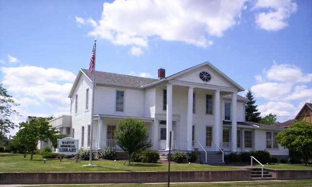
Photo: User:OHWiki, Public domain · Wikimedia Commons
Local history sources: shelbycity.oh.gov · marvinlibrary.org · en.wikipedia.org · richlandcountyhistory.com · archive.org · en.wikipedia.org
Historic places
2 places in Shelby on the National Register of Historic Places. Press a pin or a name for its whole record.
-
Marvin Memorial LibraryBuilding · Shelby · listed 1987
- Address
- 34 N. Gamble St.
- Where
- Shelby, Richland County · ZIP 44875
- What it is
- Building
- Listed on the National Register
- 1987
- NRIS reference number
- 86003493
- Coordinates
- 40.88313, -82.66202
National Register file (NPS) ↗ Search Wikipedia ↗ Street map and directions ↗ On the Cracked Buckeye map
-
Most Pure Heart Of Mary ChurchBuilding · Shelby · listed 1978
- Address
- West St. and Raymond Ave.
- Where
- Shelby, Richland County · ZIP 44875
- What it is
- Building
- Listed on the National Register
- 1978
- NRIS reference number
- 78002179
- Coordinates
- 40.88274, -82.66723
National Register file (NPS) ↗ Search Wikipedia ↗ Street map and directions ↗ On the Cracked Buckeye map
Source: National Park Service, National Register of Historic Places point file. The listing year is shown where NPS's certification date agrees with the listing's reference number. Listing recognizes significance; it does not restrict a private owner.
Water
City reservoirs (Nos. 2 & 3) fed by Black Fork Mohican River/Marsh Run The water here
- Shelby City100% of residentsCity reservoirs (Nos. 2 & 3) fed by Black Fork Mohican River/Marsh Run
Hospitals, fire stations and more
Inside Shelby's boundary: 1 hospital, 1 health center, 1 nursing home, 1 fire or EMS station, 1 college, 3 power plants, 2 high-hazard dams, 4 public schools, 1 private school, 1 poor-rated bridge, 1 library, 1 museum, 1 police station, 2 public charging sites, 2 Superfund sites, 7 Toxics Release Inventory facilities and 4 spill cases. Press a pin or a name for its whole record and its source.
Hospitals (1)
-
Medcentral Hlth Syst - Shelby HospGeneral hospital · Shelby
- What it is
- General hospital
- Address
- 199 West Main Street, Shelby, OH 44875
- County
- Richland County
- Beds
- 41
- Ownership
- Non-profit
- Medicare overall rating
- 4 of 5 stars
- Emergency department (Medicare)
- Yes
- Medicare reports it as
- Ohiohealth Shelby Hospital
- Phone
- (419) 342-5015
- Medicare ID
- 361324
Medicare Care Compare ↗ Where HIFLD got this record ↗ HIFLD hospitals (source) ↗ Street map and directions ↗
Source: HIFLD hospitals inventory via FEMA (closed hospitals it still lists left out, hospitals opened since added), with Medicare Care Compare ratings matched by name and address.
Community health centers (1)
-
Shelby Health & Wellness CenterHealth center · Shelby
- Run by
- a federally qualified health center
- Setting
- Clinic
- City
- Shelby
- Coordinates
- 40.88168, -82.65840
Find a Health Center (HRSA) ↗ HRSA data (source) ↗ Street map and directions ↗
Source: HRSA health center service delivery sites, active, September 2026 (school-based sites left out). Health centers see patients whether or not they have insurance, with fees on a sliding scale.
Nursing homes (1)
-
Crestwood Care Center2 of 5 stars · Shelby
- Address
- 225 W Main Street, Shelby, OH 44875
- Certified beds
- 130
- Residents on an average day
- 100
- Medicare overall rating
- 2 of 5 stars
- Health inspections
- 1 of 5 stars
- Staffing
- 3 of 5 stars
- Quality measures
- 5 of 5 stars
- Penalties since 2023
- 2 fines totalling $232,204, 1 payment denial (latest 2024-09-25)
- Ownership
- For profit - Corporation
- Chain
- COMMUNICARE HEALTH
- Takes
- Medicare and Medicaid
- Phone
- (419) 347-1266
- Medicare ID
- 365284
Medicare Care Compare ↗ CMS nursing home data (source) ↗ Street map and directions ↗
Source: CMS Care Compare nursing home provider and penalties files; Medicare star ratings run 1 to 5.
Fire and EMS stations (1)
-
Shelby Fire DepartmentShelby
- Address
- 40 High School Avenue, Shelby, OH 44875
- Coordinates
- 40.87931, -82.65775
USGS National Map structures (source) ↗ Street map and directions ↗
Source: USGS National Map structures (most Ohio records last updated 2019 to 2022), checked against the Columbus and Cleveland station lists. The department that answers a call is set by jurisdiction and mutual aid, not by distance.
Colleges (1)
-
Pioneer Career and Technology CenterPublic career school · Shelby
- What it is
- Public career school
- City
- Shelby
- Students, 2023-24 (12-month count)
- 118
- IPEDS unit ID
- 407522
College Navigator (NCES) ↗ IPEDS data (source) ↗ Street map and directions ↗
Source: NCES IPEDS 2024 directory, 2023-24 enrollment and tuition, graduation rates for the 2017 (four-year) and 2020 (two-year) entering classes.
Power plants (3)
-
Shelby NorthPetroleum · 2 MW
- Capacity
- 2 MW
- Main source
- Petroleum
- Technology
- Petroleum Liquids
- Operator
- American Mun Power-Ohio, Inc
- Sector
- Electric Utility
- Where
- Shelby, Richland County
- Generating units
- 1
- Built
- 2000
- EIA plant code
- 7827
EIA plant page ↗ EIA-860 (source) ↗ Street map and directions ↗
-
Shelby Solar ArraySolar · 2 MW
- Capacity
- 2 MW
- Main source
- Solar
- Technology
- Solar Photovoltaic
- Operator
- AEP Onsite Partners, LLC
- Sector
- IPP Non-CHP
- Where
- Shelby, Richland County
- Generating units
- 1
- Built
- 2019
- EIA plant code
- 63390
EIA plant page ↗ EIA-860 (source) ↗ Street map and directions ↗
-
Shelby SouthPetroleum · 2 MW
- Capacity
- 2 MW
- Main source
- Petroleum
- Technology
- Petroleum Liquids
- Operator
- City of Shelby - (OH)
- Sector
- Electric Utility
- Where
- Shelby, Richland County
- Generating units
- 1
- Built
- 2000
- EIA plant code
- 7828
EIA plant page ↗ EIA-860 (source) ↗ Street map and directions ↗
Source: EIA-860 power plant inventory via HIFLD (February 2025), with plant codes, units and years from EIA-860 2025.
High-hazard dams (2)
-
Shelby Upground Reservoir No. 2Black Fork Mohican River - Offstream · condition: fair
- Hazard class
- High: a failure would probably cost a life
- Condition
- Fair (assessed 03/18/2025)
- River or stream
- Black Fork Mohican River - Offstream
- Purpose
- Water Supply;Recreation
- Type
- Earth
- Height
- 48 ft
- Storage
- 789 acre-feet
- Completed
- 1955
- Owner type
- Local Government
- County
- Richland County
- Nearest town (NID)
- Shelby
- Last inspection
- 11/13/2024
- Emergency action plan
- Yes
- NID ID
- OH00455
National Inventory of Dams record ↗ National Inventory of Dams (source) ↗ Street map and directions ↗
-
Shelby Upground Reservoir No. 3Black Fork Mohican River - Offstream · condition: fair
- Hazard class
- High: a failure would probably cost a life
- Condition
- Fair (assessed 03/18/2025)
- River or stream
- Black Fork Mohican River - Offstream
- Purpose
- Water Supply
- Type
- Earth
- Height
- 28 ft
- Storage
- 1,320 acre-feet
- Completed
- 1993
- Owner type
- Local Government
- County
- Richland County
- Nearest town (NID)
- Shelby
- Last inspection
- 11/13/2024
- Emergency action plan
- Yes
- NID ID
- OH02853
National Inventory of Dams record ↗ National Inventory of Dams (source) ↗ Street map and directions ↗
Source: U.S. Army Corps of Engineers National Inventory of Dams, August 2026. "High hazard" rates what a failure would cost downstream, not how likely one is; the condition is the state's assessment.
Public schools (4)
-
Pioneer Career & TechnologyShelby
- Address
- 27 Ryan Rd, Shelby, OH 44875
- Kind (NCES)
- Career and Technical School
- Students, 2023-24
- 1,115
- Teachers (full-time equivalent)
- 94.62
- NCES school ID
- 390514104084
-
Shelby Elementary School4 of 5 stars · Shelby
- Address
- 109 W Smiley Ave, Shelby, OH 44875
- School district
- Shelby City School District
- Kind (NCES)
- Regular School
- Students, 2023-24
- 916
- Teachers (full-time equivalent)
- 42
- Report card, 2025-26
- 4 of 5 stars
- Performance index
- 76.3%
- Ohio building IRN
- 008730
- NCES school ID
- 391000901627
NCES school record ↗ Ohio School Report Card ↗ Street map and directions ↗
-
Shelby High School4 of 5 stars · Shelby
- Address
- 1 Whippet Way, Shelby, OH 44875
- School district
- Shelby City School District
- Kind (NCES)
- Regular School
- Students, 2023-24
- 522
- Teachers (full-time equivalent)
- 27.42
- Report card, 2025-26
- 4 of 5 stars
- Performance index
- 82.6%
- Four-year graduation rate
- 95.5%
- Ohio building IRN
- 034306
- NCES school ID
- 391000901629
NCES school record ↗ Ohio School Report Card ↗ Street map and directions ↗
-
Shelby Middle School4.5 of 5 stars · Shelby
- Address
- 109 W Smiley Ave, Shelby, OH 44875
- School district
- Shelby City School District
- Kind (NCES)
- Regular School
- Students, 2023-24
- 431
- Teachers (full-time equivalent)
- 24.83
- Report card, 2025-26
- 4.5 of 5 stars
- Performance index
- 81.2%
- Ohio building IRN
- 034298
- NCES school ID
- 391000901628
NCES school record ↗ Ohio School Report Card ↗ Street map and directions ↗
Source: NCES EDGE public school locations 2024-25 and Common Core of Data 2023-24 (type, students, teachers); Ohio School Report Cards 2025-26 (Department of Education and Workforce), matched by name within the district.
Private schools (1)
-
St Mary SchoolPrivate, Catholic · Shelby
- Address
- 26 W St, Shelby, OH 44875
- Kind
- Catholic
- Students, 2023-24
- 52
- Teachers (full-time equivalent)
- 7.3
- Students per teacher
- 7.12329
- Phone
- (419) 342-2626
- NCES private school ID
- 01061277
Source: NCES Private School Survey 2023-24.
Bridges rated poor (1)
-
State St. over Black Fork RiverPoor · built 1955
- Condition
- Poor: a deck, superstructure, substructure or culvert rated 4 or below on the 0 to 9 scale
- What it is
- Bridge
- Built
- 1955
- Length
- 40 ft
- Owner
- County
- Vehicles a day
- 1,889
- Coordinates
- 40.89658, -82.65776
National Bridge Inventory (source) ↗ Street map and directions ↗
Source: FHWA National Bridge Inventory 2025. "Poor" means one major part rated 4 or below on the 0 to 9 scale; it calls for repair, not closing, unless the state posts or closes the bridge.
Public libraries (1)
-
Marvin Memorial LibraryCentral library · Shelby
- Address
- 29 W. Whitney, Shelby, OH 44875
- What it is
- Central library
- Library system
- Marvin Memorial Library
- Open
- 2,964 hours a year, 51 weeks
- Building
- 13,000 sq ft
- System's visits, FY2024
- 33,904
- System's loans, FY2024
- 85,431
- People the system serves
- 13,114
- Phone
- (419) 347-5576
IMLS Public Libraries Survey (source) ↗ Street map and directions ↗
Source: IMLS Public Libraries Survey FY2024 (outlets and their systems). Any Ohio resident can get a free card at any Ohio public library.
Museums, historical societies, gardens and zoos (1)
-
Morton One Room School Historical SocietyHistorical society · Shelby
- What it is
- Historical society
- City
- Shelby
- Coordinates
- 40.88128, -82.65776
Search Wikipedia ↗ IMLS Museum Data Files (source) ↗ Street map and directions ↗
The museum list is IMLS's 2018 file; a museum may have closed or moved since.
Source: IMLS Museum Data Files, 2018.
Police stations (1)
-
Shelby Police DepartmentShelby
- Address
- 31 Mack Avenue, Shelby, OH 44875
- Coordinates
- 40.87677, -82.65737
USGS National Map structures (source) ↗ Street map and directions ↗
Source: USGS National Map structures, police stations, corrected and completed by hand (September 2026). The department that answers a call is set by jurisdiction, not by distance.
Public EV charging (2)
-
SHELBY SHELBY EV2 Level 2 · Shelby
- Address
- 10 Water St, Shelby, OH 44875
- Ports
- 2 Level 2
- Plugs
- J1772
- Network
- ChargePoint Network
- Hours
- 24 hours daily
- Phone
- 888-758-4389
Station Locator (NREL) ↗ Alternative Fuels Data Center (source) ↗ Street map and directions ↗
-
Valero1 Level 2 · Shelby
- Address
- 172 N Gamble St, Shelby, OH 44875
- Ports
- 1 Level 2
- Plugs
- J1772
- Network
- Non-Networked
- Hours
- 24 hours daily
- Phone
- 567-292-9449
Station Locator (NREL) ↗ Alternative Fuels Data Center (source) ↗ Street map and directions ↗
Source: NREL Alternative Fuels Data Center station list (May 2026), public and open stations, the posts at one address counted as one site.
Superfund sites (2)
-
Shelby StandardSuperfund program · Shelby
- Address
- 116 N Broadway St, Shelby, OH 44875
- County
- Richland County
- Status
- Superfund program site, not on the National Priorities List
- EPA program ID
- OH0000114140
- EPA registry ID
- 110004731229
EPA facility record ↗ EPA Facility Registry Service (source) ↗ Street map and directions ↗
-
Syn Lube Prodicts and ServicesSuperfund program · Shelby
- Address
- 110 Broadway St., Shelby, OH 44875
- County
- Richland County
- Status
- Superfund program site, not on the National Priorities List
- EPA program ID
- OHN000510320
- EPA registry ID
- 110067349836
EPA facility record ↗ EPA Facility Registry Service (source) ↗ Street map and directions ↗
Source: EPA Facility Registry Service, Superfund (SEMS) and National Priorities List sites. Many program sites were assessed and needed no cleanup.
Facilities reporting toxic releases (7)
-
Arcelormittal Tubular Products Shelby Llc.Toxics Release Inventory · Shelby
- Address
- 21 Allison Dr, Shelby, OH 44875
- County
- Richland County
- Status
- Reports to the Toxics Release Inventory (active)
- EPA program ID
- 44875LTVCP21ALL
- EPA registry ID
- 110012705698
EPA facility record ↗ EPA Facility Registry Service (source) ↗ Street map and directions ↗
-
Arcelormittal Tubular Products Usa Llc (0370020133)Toxics Release Inventory · Shelby
- Address
- 132 W. Main Street, Shelby, OH 44875
- County
- Richland County
- Status
- Reports to the Toxics Release Inventory (open)
- EPA program ID
- 44875HSTLT140WE
- EPA registry ID
- 110041568568
EPA facility record ↗ EPA Facility Registry Service (source) ↗ Street map and directions ↗
-
Miami Systems Corp Shelby Business Forms DivToxics Release Inventory · Shelby
- Address
- 40 High School Ave., Shelby, OH 44875
- County
- Richland County
- Status
- Reports to the Toxics Release Inventory (active)
- EPA program ID
- 44875FRMSH40HIG
- EPA registry ID
- 110002112516
EPA facility record ↗ EPA Facility Registry Service (source) ↗ Street map and directions ↗
-
Mtd Consumer Group Inc - Shelby FacilityToxics Release Inventory · Shelby
- Address
- 305 Mansfield Ave, Shelby, OH 44875
- County
- Richland County County
- Status
- Reports to the Toxics Release Inventory (active)
- EPA program ID
- 4487WMTDCN35MAN
- EPA registry ID
- 110064365413
EPA facility record ↗ EPA Facility Registry Service (source) ↗ Street map and directions ↗
-
Mtd ShelbyToxics Release Inventory · Shelby
- Address
- 18 Allison Dr (Coip Bldg. 12), Shelby, OH 44875
- County
- Richland County
- Status
- Reports to the Toxics Release Inventory (active)
- EPA program ID
- 44875MTDSHCOIPB
- EPA registry ID
- 110015782312
EPA facility record ↗ EPA Facility Registry Service (source) ↗ Street map and directions ↗
-
Shelby Municipal Light Plant (0370020002)Toxics Release Inventory · Shelby
- Address
- 34 Mansfield Ave., Shelby, OH 44875
- County
- Richland County
- Status
- Reports to the Toxics Release Inventory (active)
- EPA program ID
- 44875SHLBY34MAN
- EPA registry ID
- 110000391816
EPA facility record ↗ EPA Facility Registry Service (source) ↗ Street map and directions ↗
-
Tech Form IndustriesToxics Release Inventory · Shelby
- Address
- 15 East Smiley Avenue, Shelby, OH 44875
- County
- Richland County
- Status
- Reports to the Toxics Release Inventory (active)
- EPA program ID
- 44875TCHFR15ESM
- EPA registry ID
- 110002112525
EPA facility record ↗ EPA Facility Registry Service (source) ↗ Street map and directions ↗
Source: EPA Facility Registry Service, Toxics Release Inventory reporters. Reporting a release is required of large users of listed chemicals; it is not by itself a violation.
Spills reported since 2021 (4)
-
Fuel Diesel / Diesel Fuel (Vehicle On Or Off Road) Reached water2025-08-21 · Shelby
- Reported
- 2025-08-21
- What spilled
- Fuel Diesel / Diesel Fuel (Vehicle On Or Off Road)
- Reached a waterway
- 99 - Unnamed
- Where
- Shelby, Richland County
- Ohio EPA district office
- NWDO
- Ohio EPA case number
- 2508EPA0001428
Ohio EPA spill reports (source) ↗ Street map and directions ↗
-
Fuel Diesel / Diesel Fuel (Vehicle On Or Off Road)2025-03-16 · Shelby
- Reported
- 2025-03-16
- What spilled
- Fuel Diesel / Diesel Fuel (Vehicle On Or Off Road)
- Largest amount reported
- 50 gallons
- Where
- Shelby, Richland County
- Ohio EPA district office
- NWDO
- Ohio EPA case number
- 2503EPA0000370
Ohio EPA spill reports (source) ↗ Street map and directions ↗
-
Material Undetermined / Other2024-01-24 · Shelby
- Reported
- 2024-01-24
- What spilled
- Material Undetermined / Other
- Where
- Shelby, Richland County
- Ohio EPA district office
- NWDO
- Ohio EPA case number
- 2401EPA0000117
Ohio EPA spill reports (source) ↗ Street map and directions ↗
-
Oil Hydraulic Fluid(S) Reached water2026-07-10 · Shelby
- Reported
- 2026-07-10
- What spilled
- Oil Hydraulic Fluid(S)
- Reached a waterway
- 99 - Unnamed
- Where
- Shelby, Richland County
- Ohio EPA district office
- NWDO
- Ohio EPA case number
- 2607EPA0001253
Ohio EPA spill reports (source) ↗ Street map and directions ↗
Source: Ohio EPA emergency response spill reports, 2021 to September 2026, one point per case where Ohio EPA placed it. A report is what the caller or responder recorded; amounts are often blank or estimated.
Its ZIP codes
Each ZIP code that touches Shelby, with the share of its residents who live here and the same headline figures as the ZIP page.
| ZIP | Share | Water | Radon | Home value | Schools | Flood |
|---|---|---|---|---|---|---|
| 44875 Shelby | 67% | City reservoirs (Nos. 2 & 3) fed by Black Fork Mohican River/Marsh Run | 6.2 pCi/L average radon | Median year built 1951 | Shelby City · 4 stars overall | 4.6% of residents in the 1% floodplain |
Local government
Who holds office in Shelby, how its elections and ballot issues came out, and the state auditor's record.
Ballot issues
| Date | Issue | For | Against | Result |
|---|---|---|---|---|
| 2015-11-03 | Issue: City of Shelby - Gas Aggregation | 1,411 | 950 | Passed (59.76% for) |
Elections for office
| Date | Office | Candidates and votes |
|---|---|---|
| 2015-11-03 | Mayor | Steven L. Schag 2,107, 100.0% |
| 2015-11-03 | Director of Law | Gordon Eyster 1,937, 100.0% |
| 2015-11-03 | Dir of Finance Public Record | Steve Lifer 1,361, 58.24%; Cohen Lewis 976, 41.76% |
| 2015-11-03 | Council at Large | Steve McLaughlin 2,011, 100.0% |
| 2015-11-03 | Council Member, 4th Ward | Nathan Martin 595, 80.62%; Christopher P Colyer 143, 19.38% |
| 2015-11-03 | Council Member, 3rd Ward | Garland John Gates 337, 100.0% |
| 2015-11-03 | Council Member, 2nd Ward | Derrin Roberts 327, 58.6%; Keith B. Evans 231, 41.4% |
| 2015-11-03 | Council Member, 1st Ward | Charles Roub 354, 56.19%; Patricia Carlisle 276, 43.81% |
Winners in bold. Results from the county board of elections' official canvass unless marked.
Auditor of State record
- No fiscal caution, watch or emergency on the Auditor of State's lists.
- Financial Health Indicators (the Auditor of State's 17 measures; critical / cautionary / positive): 2020 0 / 2 / 15; 2021 1 / 1 / 15; 2022 1 / 3 / 13; 2023 0 / 4 / 13; 2024 1 / 3 / 13; 2025 0 / 3 / 13.
- Financial Audit, 2024, released 2026-01-22
- OP&F Examination, 2023, released 2025-05-08
- Financial Audit, 2023, released 2024-12-24
The county
Richland County: 12 ZIP codes, 27 cities, villages and townships, 124,341 people.
Nearby places
Rain and snow
How much has actually fallen on Shelby, day by day, from 1892 to now. Daily totals, not averages.
- rain, last 30 days
- 1.67 in
- 2026-09-30 to 2026-10-29
- rain so far in 2026
- 37.7 in
- 1.9 in above normal for the date
- snow so far in 2026
- 19.8 in
- a normal year brings 35.2 in
- a normal year
- 42.5 in
- average of 30 years, 1991-2020
| Month | Rain (in) | Snow (in) | Days counted |
|---|---|---|---|
| October 2026 | 1.67 | — | 29 |
| September 2026 | 4.22 | — | 30 |
| August 2026 | 3.89 | — | 31 |
| July 2026 | 2.91 | — | 31 |
| June 2026 | 3.45 | — | 30 |
| May 2026 | 6.54 | — | 31 |
| April 2026 | 8.37 | — | 30 |
| March 2026 | 4.69 | — | 31 |
| February 2026 | 0.99 | 3.8 | 28 |
| January 2026 | 1.00 | 16.0 | 31 |
| December 2025 | 3.45 | 10.6 | 31 |
| November 2025 | 1.86 | 0.3 | 30 |
| Wettest year | 2025 — 59.3 in |
|---|---|
| Driest year | 1963 — 23.7 in |
| Snowiest year | 1893 — 108.2 in |
| Wettest day on record | 21 August 2007 — 5.34 in |
| Heaviest snowfall in a day | 25 January 2026 — 11.61 in |
| Deepest snow on the ground | 9 January 1905 — 22.65 in |
Mostly estimated. Only 7% of these days come from a gauge standing inside Shelby - the rest are worked out from the nearest gauges around it, so read them as close estimates rather than readings.
48,771 days of records, 1892-12-01 to 2026-10-29. Source: NOAA NCEI GHCN-Daily, 3,240 gauges in and around Ohio. A day is "gauged" when a gauge standing inside the boundary reported it, and the value is the mean of those gauges. Otherwise it is interpolated by inverse distance from every gauge reporting within 50 miles. Nothing is carried forward, back-filled or smoothed. Against NOAA nClimDiv county monthly precipitation over 136,848 complete county-months (checked 2026-10-31): correlation 0.9515, median absolute difference 0.217 in a month. Built 2026-10-31 from the Cracked Buckeye precipitation archive. Snow is the softer number — snowfall is measured by hand with a ruler, no agency publishes a gridded county snowfall series, and blowing snow defeats every observer.
Environmental permits and filings
What Ohio EPA has on file for Shelby: permits, inspections, violations, cleanups and the state loans behind sewer and water work. Every line links to the agency's own document.
- facilities and sites on file
- 42
- those placed on the map inside Shelby
| Program | Facilities and sites |
|---|---|
| Hazardous waste | 15 |
| Air pollution | 8 |
| Wastewater and stormwater discharge | 8 |
| State sewer loans | 6 |
| Sewer and water-line construction | 2 |
| Contaminated-site cleanup | 1 |
| Public drinking water | 1 |
| State water loans | 1 |
| Date | Facility or site | What |
|---|---|---|
| SHELBY CITY PWS | Public drinking water notice of violation | |
| CENTRAL OHIO INDUSTRIAL PARK | Wastewater and stormwater discharge permit | |
| SHELBY CITY PWS | Public drinking water inspection | |
| PENWELL EVENT CENTER | Wastewater and stormwater discharge permit | |
| DIVERSIFIED ASSEMBLIES INC | Air pollution report | |
| SHELBY CITY PWS | Public drinking water report | |
| SHELBY WWTP | Sewer and water-line construction permit | |
| SHELBY WWTP | Sewer and water-line construction permit | |
| ARCELOR MITTAL TUBULAR PRODUCTS USA LLC | Air pollution inspection | |
| SHELBY CITY PWS | Public drinking water plan | |
| SHELBY CITY PWS | Public drinking water inspection | |
| SHELBY CITY PWS | Public drinking water monitoring results | |
| SHELBY CITY PWS | Public drinking water compliance letter | |
| SHELBY CITY PWS | Public drinking water monitoring results | |
| SHELBY CITY PWS | Public drinking water inspection | |
| SHELBY MOBILE HOME PARK REDEVELOPMENT | Wastewater and stormwater discharge permit | |
| SHELBY CITY PWS | Public drinking water compliance letter | |
| SHELBY CITY PWS | Public drinking water report | |
| SHELBY MOBILE HOME PARK REDEVELOPMENT | Wastewater and stormwater discharge permit | |
| SHELBY CITY PWS | Public drinking water plan | |
| PROGRESS DRIVE GENERATION STATION | Air pollution inspection | |
| SHELBY CITY PWS | Public drinking water inspection | |
| ARCELORMITTAL TUBULAR PRODUCTS USA LLC | Air pollution permit | |
| SHELBY CITY PWS | Public drinking water inspection | |
| BUCKEYE SUPERSTORE - NEW DEALERSHIP | Wastewater and stormwater discharge permit |
Source: Ohio EPA eDocument portal (edocpub.epa.ohio.gov), indexed 2026-10-14. Facilities are placed on the map from Ohio EPA's own map layers, EPA's Facility Registry, coordinates written in the filings, or a geocoded street address. A permit filed under a private person's name (most are household septic systems) is counted but never named, placed or linked; licenses for individual workers and open-burning notices are left out entirely.
Quick answers
What county is Shelby, Ohio in?
Shelby is a city in Richland County, Ohio, with 9,284 residents.
When was Shelby, Ohio founded?
Shelby was settled 1818; laid out 1834; incorporated 1853 (village); 1921 (city). Founders on record: John Gamble (1880 county history) or James Gamble (city history). Source
How did Shelby, Ohio get its name?
The 1880 county history, quoting S. Source
What ZIP code is Shelby, Ohio?
Most of Shelby is in ZIP code 44875.
Where does Shelby, Ohio get its water?
The main water source for Shelby (Shelby City): City reservoirs (Nos. 2 & 3) fed by Black Fork Mohican River/Marsh Run.
Cite this page
Cite this page as:
Cracked Buckeye, "Shelby, Richland County", https://crackedbuckeye.com/place/shelby/, built 2026-10-31, accessed [date].
How to cite · Report a correction · Built 2026-10-31
