Water system
Shelby City
EPA ID OH7004511 · Richland County · 9,453 people served · owned by a local government
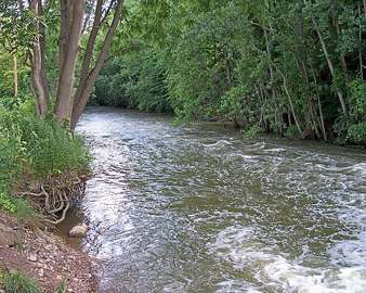
Shelby City treats its own water from City reservoirs (Nos. 2 & 3) fed by Black Fork Mohican River/Marsh Run.
The system's record
- Water bodies
- Reservoir 2, Reservoir 3, Black Fork Mohican River, Marsh Run
- Raw intakes
- Reservoir
Black Fork Creek
Marsh Run - Serves
- 9,453 people · Richland County
- EPA ID
- OH7004511
Water diverted from Black Fork Mohican River and Marsh Run creek into two/three on-site storage reservoirs (588 million gal combined capacity) before treatment; no groundwater used.
About this area's water
Water quality & impurities
EPA compliance record
Lead at the tap: 90th-percentile result 0 ppb in 2025 (action level 15 ppb).
EPA record: no health-based violations since 2015.
Sourcesverified
Compiled from the utility's own reports and public records, then independently re-checked against primary sources.
Main supplier in 1 ZIP code
Serves
Main water supplier in 1 ZIP code
- 44875 · Shelby68% of residents
Population-weighted resident shares; a ZIP code can have more than one system on record. Recomputed from each ZIP's own system list, not from the map's cached footprint.
Buys from · Sells to
Shelby City does not buy water from another system on record; it treats its own source water.
No other system is on record buying water from Shelby City.
Photograph
On the map
Show this system's territory on the map — 1 ZIP code in all.
Sources
U.S. EPA SDWIS and Community Water System Service Area Boundaries (v3, 2026), Ohio EPA primacy data, 2020 census blocks: the system serving most residents, traced through purchases to the treating utility; Ohio EPA 2023 Sewer and Water Rate Survey (Ohio State, May 2025) for household bills; Ohio EPA DEFA loan awards since 2016 for the loans paragraph · EPA SDWIS · EPA service area boundaries · Ohio EPA drinking water · Ohio EPA rate survey
Shelby City's own pages: shelbycity.oh.gov, shelbycity.oh.gov
Notable facts: shelbycity.oh.gov, shelbycity.oh.gov, shelbycity.oh.gov
History: shelbycity.oh.gov, shelbycity.oh.gov, shelbycity.oh.gov, shelbycity.oh.gov
Water quality: shelbycity.oh.gov
Planned work: shelbycity.oh.gov, shelbycity.oh.gov
Water pressure: shelbycity.oh.gov, shelbycity.oh.gov
Capital projects: shelbycity.oh.gov, shelbycity.oh.gov, shelbycity.oh.gov, richlandsource.com
Rates: richlandsource.com, richlandsource.com, codelibrary.amlegal.com, shelbycity.oh.gov
Sewers: shelbycity.oh.gov, shelbycity.oh.gov, shelbycity.oh.gov
Treatment: shelbycity.oh.gov, shelbycity.oh.gov
Supply stress: shelbycity.oh.gov, shelbycity.oh.gov