Local events in Ripley
Ripley itself has 1 event posted in the next 90 days; the others here are within 20 miles. All local events in Ripley
Checked October 20; the events page is refreshed daily.
Deep dives about Ripley
Long reads built from maps, newspapers and public records. All deep dives
Notable people from Ripley
Ohioans tied to this place, each with a sourced profile. All notable Ohioans
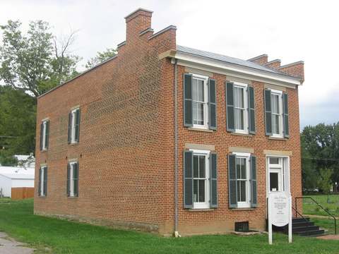
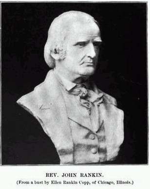
History from Ripley
People and inventions tied to this place, each with its sources. All people · All inventions
How Ripley began
Ripley began in 1812 as Staunton, laid out on the Ohio River by Revolutionary War veteran Colonel James Poage, and was renamed in 1816 for War of 1812 general Eleazar Wheelock Ripley. Its riverfront location, directly across from Kentucky, made it one of Ohio's busiest Underground Railroad crossings from the 1820s through the Civil War, led by the Presbyterian minister John Rankin and the formerly enslaved iron manufacturer John P. Parker. The village peaked at 2,715 residents in 1860 and today markets itself as 'Freedom's Landing.'
Settled 1804, platted 1812, incorporated 1816, by Colonel James Poage.
Where the name comes from
Laid out in 1812 as Staunton, the town was renamed Ripley in 1816 to honor General Eleazar Wheelock Ripley, an American officer of the War of 1812.
Before the town
No Native American village or mound specific to Ripley is recorded in the sources checked, but the Ohio River crossing at Ripley, where the river narrows, was a favored crossing point for Shawnee and Miami travelers moving between Kentucky hunting grounds and the Ohio country before American settlement; Brown County tradition holds the young Tecumseh visited the area.
Nations recorded here: Shawnee, Miami.
Timeline
- — Colonel James Poage, a Revolutionary War veteran, arrives to claim 1,000 acres granted to him in the Virginia Military District along the Ohio River.
- — Poage and his family lay out the town of Staunton on the site.
- — The town is renamed Ripley, for General Eleazar Wheelock Ripley.
- — The Ripley Presbyterian church is organized in the spring by the Presbytery of Chillicothe; James Poage donates a lot, and a 45-by-45-foot brick church is built in 1817 and used until 1854.
- — The county seat is located at Ripley in the latter part of the year, according to the 1883 history; the next year a different site on Straight Creek is bought and the town of Bridgewater laid out. The same year a Masonic lodge of dispensation is granted at the village.
- — Presbyterian minister John Rankin moves to Ripley and begins sheltering freedom seekers; he builds his hilltop house, Liberty Hill, in 1825 and signals escapes with a lantern visible across the river.
- — The printing press brought into the county, first used for the Benefactor at Levanna in 1820, is moved to Ripley by James Finley; John and James Carnahan buy it in 1823 and publish until 1824.
- — Nathaniel Collins is the first mayor of Ripley on the 1883 history's list of mayors, which runs from 1826 to 1882.
- — Rev. John Rankin establishes a female seminary in Ripley with Miss Riley as first assistant; a college is founded in 1840 with Rankin as president, and the school continues until 1849 under Rev. Jonathan Taylor.
- — The Grand Lodge of Ohio charters Union Lodge No. 71, F. & A. M., at Ripley.
- — The Christian Church, begun as a society in 1842 and 170 members strong by 1845, builds a church at a cost of $7,000, with Elder Matthew Gardner assisting at the dedication.
- — Fire destroys D. H. Murphy's brick building at Front and Main, with the Masonic hall on its third story and much of his store stock; the lodge meets in Thompson Hall and builds a new hall, finished in 1855.
- — John P. Parker, a formerly enslaved ironworker who had purchased his own freedom in 1845, settles in Ripley, opens an iron foundry (later the Phoenix Foundry), and becomes an Underground Railroad conductor, crossing the Ohio River at night into Kentucky to guide escaping slaves; he is later credited with helping some 400 people to freedom and patents inventions including a tobacco press and soil pulverizer.
- — The Black Baptist church is founded; until this year the town's few Black churchgoers had attended the Presbyterian church.
- — Ripley's population peaks at 2,715 before the Civil War, its busiest era as a river town.
- — C. W. and S. G. Boyd rebuild the town's sawmill and add a planing mill, raising their business from $10,000 to $200,000 a year; by July 1882 they have virtually monopolized the county's lumber trade.
- — The Methodist congregation completes a new church on Second street at a cost of $35,000 including furnishings; the Disciples buy the old Second Presbyterian church on Third street for $4,000 the same year.
- — The census counts 1,750 people in Ripley, 1,591 in 2020.
Stories
An ironmaster's nighttime crossings
John P. Parker was born in 1827 in Norfolk, Virginia, the son of an enslaved mother and a white father, and was sold at auction to an Alabama doctor by age eight. Apprenticed at an iron foundry, he taught himself the trade and in 1845, at eighteen, bought his own freedom for eighteen hundred dollars. By 1853 he had settled in Ripley, where he ran an iron foundry by day, invented a tobacco press and a soil pulverizer, and became one of the few African Americans to hold a United States patent before 1900. By night he rowed across the Ohio River into Kentucky, often alone and armed, to guide enslaved people north; he is credited with helping roughly four hundred people escape over the years, routinely delivering them to fellow conductor John Rankin's house on the bluff above town. His riverside home and foundry site in Ripley are preserved today as the John P. Parker House, a National Register landmark and small museum.
Photographs
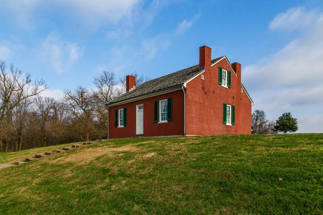
Photo: Christopher L. Riley, CC BY-SA 4.0 · Wikimedia Commons
Local history sources: en.wikipedia.org · en.wikipedia.org · en.wikipedia.org · en.wikipedia.org · commons.wikimedia.org · touringohio.com · en.wikipedia.org · archive.org
Historic places
3 places in Ripley on the National Register of Historic Places, 1 of them National Historic Landmark. Press a pin or a name for its whole record.
-
Parker, John P., House LandmarkBuilding · Ripley · listed 1997
- Address
- 300 Front St.
- Where
- Ripley, Brown County · ZIP 45167
- What it is
- Building
- Listed on the National Register
- 1997
- National Historic Landmark
- Yes
- NRIS reference number
- 97000340
- Coordinates
- 38.75023, -83.84900
National Register file (NPS) ↗ Search Wikipedia ↗ Street map and directions ↗ On the Cracked Buckeye map
-
Farmers Branch, State Bank of OhioBuilding · Ripley · listed 1983
- Address
- 14 Front St.
- Where
- Ripley, Brown County · ZIP 45167
- What it is
- Building
- Listed on the National Register
- 1983
- NRIS reference number
- 83001946
- Coordinates
- 38.74570, -83.84663
National Register file (NPS) ↗ Search Wikipedia ↗ Street map and directions ↗ On the Cracked Buckeye map
-
Parker, John P., HouseBuilding · Ripley · listed 1980
- Address
- 300 Front St.
- Where
- Ripley, Brown County · ZIP 45167
- What it is
- Building
- Listed on the National Register
- 1980
- NRIS reference number
- 80002944
- Coordinates
- 38.75014, -83.84922
National Register file (NPS) ↗ Search Wikipedia ↗ Street map and directions ↗ On the Cracked Buckeye map
Source: National Park Service, National Register of Historic Places point file. The listing year is shown where NPS's certification date agrees with the listing's reference number. Listing recognizes significance; it does not restrict a private owner.
Water
Mostly private wells The water here
- Brown County Rural Water99% of residentsOhio River Valley Aquifer (wells)
- Adams County Regional Wd1% of residentsOhio River Valley Aquifer (wells near Manchester)
Hospitals, fire stations and more
Inside Ripley's boundary: 1 fire or EMS station, 3 public schools, 1 private school, 1 poor-rated bridge, 1 library, 3 museums, 1 Superfund site, 2 Toxics Release Inventory facilities and 2 spill cases. Press a pin or a name for its whole record and its source.
Fire and EMS stations (1)
-
Ripley Fire DepartmentRipley
- Address
- 119 Waterworks Road, Ripley, OH 45167
- Coordinates
- 38.73088, -83.83908
USGS National Map structures (source) ↗ Street map and directions ↗
Source: USGS National Map structures (most Ohio records last updated 2019 to 2022), checked against the Columbus and Cleveland station lists. The department that answers a call is set by jurisdiction and mutual aid, not by distance.
Public schools (3)
-
Ripley Union Lewis Huntington Elementary School3.5 of 5 stars · Ripley
- Address
- 502 S 2nd St, Ripley, OH 45167
- School district
- Ripley-Union-Lewis-Huntington Local School District
- Kind (NCES)
- Regular School
- Students, 2023-24
- 378
- Teachers (full-time equivalent)
- 23
- Report card, 2025-26
- 3.5 of 5 stars
- Performance index
- 76.6%
- Ohio building IRN
- 121434
- NCES school ID
- 390460700516
NCES school record ↗ Ohio School Report Card ↗ Street map and directions ↗
-
Ripley Union Lewis Huntington Junior High SchoolRipley
- Address
- 1317 S 2nd St, Ripley, OH 45167
- Kind (NCES)
- Regular School
- Students, 2023-24
- 109
- NCES school ID
- 390460705295
-
Ripley-Union-Lewis-Huntington Senior High SchoolRipley
- Address
- 1317 S 2nd St, Ripley, OH 45167
- Kind (NCES)
- Regular School
- Students, 2023-24
- 235
- Teachers (full-time equivalent)
- 23
- NCES school ID
- 390460702421
Source: NCES EDGE public school locations 2024-25 and Common Core of Data 2023-24 (type, students, teachers); Ohio School Report Cards 2025-26 (Department of Education and Workforce), matched by name within the district.
Private schools (1)
-
St Michael SchoolPrivate, Catholic · Ripley
- Address
- 300 Market St, Ripley, OH 45167
- Kind
- Catholic
- Students, 2023-24
- 128
- Teachers (full-time equivalent)
- 11.4
- Students per teacher
- 11.2281
- Phone
- (937) 515-3944
- NCES private school ID
- 01056234
Source: NCES Private School Survey 2023-24.
Bridges rated poor (1)
-
Stephenson Road over StreamPoor · built 1930
- Condition
- Poor: a deck, superstructure, substructure or culvert rated 4 or below on the 0 to 9 scale
- What it is
- Bridge
- Built
- 1930
- Length
- 6 ft
- Owner
- County
- Vehicles a day
- 951
- Coordinates
- 38.72714, -83.83002
National Bridge Inventory (source) ↗ Street map and directions ↗
Source: FHWA National Bridge Inventory 2025. "Poor" means one major part rated 4 or below on the 0 to 9 scale; it calls for repair, not closing, unless the state posts or closes the bridge.
Public libraries (1)
-
Union Township Public LibraryCentral library · Ripley
- Address
- 27 Main, Ripley, OH 45167
- What it is
- Central library
- Library system
- Union Township Public Library
- Open
- 2,808 hours a year, 52 weeks
- Building
- 6,425 sq ft
- System's visits, FY2024
- 25,584
- People the system serves
- 13,774
- Phone
- (937) 392-4871
IMLS Public Libraries Survey (source) ↗ Street map and directions ↗
Source: IMLS Public Libraries Survey FY2024 (outlets and their systems). Any Ohio resident can get a free card at any Ohio public library.
Museums, historical societies, gardens and zoos (3)
-
John P Parker Historical SocietyHistorical society · Ripley
- What it is
- Historical society
- City
- Ripley
- Coordinates
- 38.74956, -83.84923
Search Wikipedia ↗ IMLS Museum Data Files (source) ↗ Street map and directions ↗
The museum list is IMLS's 2018 file; a museum may have closed or moved since.
-
Ohio Tobacco MuseumHistory museum · Ripley
- What it is
- History museum
- City
- Ripley
- Coordinates
- 38.73697, -83.84018
Search Wikipedia ↗ IMLS Museum Data Files (source) ↗ Street map and directions ↗
The museum list is IMLS's 2018 file; a museum may have closed or moved since.
-
Ripley MuseumHistory museum · Ripley
- What it is
- History museum
- City
- Ripley
- Coordinates
- 38.74847, -83.84711
Search Wikipedia ↗ IMLS Museum Data Files (source) ↗ Street map and directions ↗
The museum list is IMLS's 2018 file; a museum may have closed or moved since.
Source: IMLS Museum Data Files, 2018.
Superfund sites (1)
-
Us Shoe Site Aka Former Us Shoe FacilitySuperfund program · Ripley
- Address
- 1009 South Second Street, Ripley, OH 45167
- County
- Brown County
- Status
- Superfund program site, not on the National Priorities List
- EPA program ID
- OHN000508150
- EPA registry ID
- 110002112918
EPA facility record ↗ EPA Facility Registry Service (source) ↗ Street map and directions ↗
Source: EPA Facility Registry Service, Superfund (SEMS) and National Priorities List sites. Many program sites were assessed and needed no cleanup.
Facilities reporting toxic releases (2)
-
Pepsi-Cola Bottling CoToxics Release Inventory · Ripley
- Address
- 1111 2Nd St, Ripley, OH 45167
- County
- Brown County
- Status
- Reports to the Toxics Release Inventory (active)
- EPA program ID
- 45167PPSCL11112
- EPA registry ID
- 110002112927
EPA facility record ↗ EPA Facility Registry Service (source) ↗ Street map and directions ↗
-
Us Shoe Site Aka Former Us Shoe FacilityToxics Release Inventory · Ripley
- Address
- 1009 South Second Street, Ripley, OH 45167
- County
- Brown County
- Status
- Reports to the Toxics Release Inventory (active)
- EPA program ID
- 45167NTDST1009S
- EPA registry ID
- 110002112918
EPA facility record ↗ EPA Facility Registry Service (source) ↗ Street map and directions ↗
Source: EPA Facility Registry Service, Toxics Release Inventory reporters. Reporting a release is required of large users of listed chemicals; it is not by itself a violation.
Spills reported since 2021 (2)
-
Bentonite / Drilling Mud Reached water2025-02-04 · Ripley
- Reported
- 2025-02-04
- What spilled
- Bentonite / Drilling Mud
- Largest amount reported
- 200 gallons
- Reached a waterway
- 08 - Redoak Creek
- Where
- Ripley, Brown County
- Ohio EPA district office
- SWDO
- Ohio EPA case number
- 2502EPA0000148
Ohio EPA spill reports (source) ↗ Street map and directions ↗
-
Sewage Human Reached water2021-09-09 · Ripley
- Reported
- 2021-09-09
- What spilled
- Sewage Human
- Reached a waterway
- 08 - Ohio River
- Where
- Ripley, Brown County
- Ohio EPA district office
- SWDO
- Ohio EPA case number
- 2109EPA0001425
Ohio EPA spill reports (source) ↗ Street map and directions ↗
Source: Ohio EPA emergency response spill reports, 2021 to September 2026, one point per case where Ohio EPA placed it. A report is what the caller or responder recorded; amounts are often blank or estimated.
Its ZIP codes
Each ZIP code that touches Ripley, with the share of its residents who live here and the same headline figures as the ZIP page.
| ZIP | Share | Water | Radon | Home value | Schools | Flood |
|---|---|---|---|---|---|---|
| 45167 Ripley | 46% | Mostly private wells | 2.4 pCi/L average radon | Appraisal records without year built | Ripley-Union-Lewis-Huntington Local · 3.5 stars overall | 15% of residents in the 1% floodplain |
Local government
Who holds office in Ripley, how its elections and ballot issues came out, and the state auditor's record.
Ballot issues
| Date | Issue | For | Against | Result |
|---|---|---|---|---|
| 2021-11-02 | Issue: Village of Ripley Purchase Contract (Water) | 317 | 79 | Passed (80.05% for) |
Elections for office
| Date | Office | Candidates and votes |
|---|---|---|
| 2021-11-02 | Member of Council | Scotty L. Eagan 269, 39.44%; Charles D. Poole 240, 35.19%; Alvin Wallace 173, 25.37% |
| 2021-11-02 | Mayor | Nowana Faith Bingaman 258, 66.49%; Tom Leonard 130, 33.51% |
Winners in bold. Results from the county board of elections' official canvass unless marked.
Auditor of State record
- No fiscal caution, watch or emergency on the Auditor of State's lists.
- Financial Audit, 2019 to 2020, released 2025-03-04
The county
Brown County: 11 ZIP codes, 25 cities, villages and townships, 39,201 people.
Nearby places
Rain and snow
How much has actually fallen on Ripley, day by day, from 1887 to now. Daily totals, not averages.
- rain, last 30 days
- 1.88 in
- 2026-09-30 to 2026-10-29
- rain so far in 2026
- 35.7 in
- 4.9 in below normal for the date
- snow so far in 2026
- 11.2 in
- a normal year brings 14.4 in
- a normal year
- 47.9 in
- average of 30 years, 1991-2020
| Month | Rain (in) | Snow (in) | Days counted |
|---|---|---|---|
| October 2026 | 1.88 | — | 29 |
| September 2026 | 3.68 | — | 30 |
| August 2026 | 3.92 | — | 31 |
| July 2026 | 3.89 | — | 31 |
| June 2026 | 4.42 | — | 30 |
| May 2026 | 7.01 | — | 31 |
| April 2026 | 2.83 | — | 30 |
| March 2026 | 5.00 | 0.1 | 31 |
| February 2026 | 0.98 | 3.9 | 28 |
| January 2026 | 2.12 | 7.1 | 31 |
| December 2025 | 2.65 | 6.1 | 31 |
| November 2025 | 3.19 | 0.6 | 30 |
| Wettest year | 2011 — 64.4 in |
|---|---|
| Driest year | 1930 — 21.5 in |
| Snowiest year | 1917 — 54.0 in |
| Wettest day on record | 14 July 1938 — 5.73 in |
| Heaviest snowfall in a day | 17 January 1994 — 16.75 in |
| Deepest snow on the ground | 21 January 1994 — 21.43 in |
Mostly estimated. Only 1% of these days come from a gauge standing inside Ripley - the rest are worked out from the nearest gauges around it, so read them as close estimates rather than readings.
50,409 days of records, 1887-09-01 to 2026-10-29. Source: NOAA NCEI GHCN-Daily, 3,240 gauges in and around Ohio. A day is "gauged" when a gauge standing inside the boundary reported it, and the value is the mean of those gauges. Otherwise it is interpolated by inverse distance from every gauge reporting within 50 miles. Nothing is carried forward, back-filled or smoothed. Against NOAA nClimDiv county monthly precipitation over 136,848 complete county-months (checked 2026-10-31): correlation 0.9515, median absolute difference 0.217 in a month. Built 2026-10-31 from the Cracked Buckeye precipitation archive. Snow is the softer number — snowfall is measured by hand with a ruler, no agency publishes a gridded county snowfall series, and blowing snow defeats every observer.
Environmental permits and filings
What Ohio EPA has on file for Ripley: permits, inspections, violations, cleanups and the state loans behind sewer and water work. Every line links to the agency's own document.
- facilities and sites on file
- 19
- those placed on the map inside Ripley
| Program | Facilities and sites |
|---|---|
| Contaminated-site cleanup | 6 |
| Site assessment | 3 |
| Brownfield | 2 |
| Hazardous waste | 2 |
| Underground injection wells | 2 |
| Public drinking water | 1 |
| State sewer loans | 1 |
| State water loans | 1 |
| Voluntary cleanup | 1 |
| Date | Facility or site | What |
|---|---|---|
| US SHOE SITE AKA FORMER US SHOE FACILITY | Underground injection wells inspection | |
| RIPLEY WWTP | State sewer loans | |
| US SHOE SITE AKA FORMER US SHOE FACILITY | Underground injection wells monitoring results | |
| US SHOE CORP, RIPLEY | Contaminated-site cleanup cleanup response | |
| RIPLEY WWTP | State sewer loans | |
| RIPLEY WWTP | State sewer loans | |
| RIPLEY WWTP | State sewer loans | |
| US SHOE SITE AKA FORMER US SHOE FACILITY | Underground injection wells inspection | |
| US SHOE CORP, RIPLEY | Contaminated-site cleanup cleanup response | |
| US SHOE SITE AKA FORMER US SHOE FACILITY | Underground injection wells inspection | |
| US SHOE SITE AKA FORMER US SHOE FACILITY | Underground injection wells monitoring results | |
| US SHOE CORP, RIPLEY | Contaminated-site cleanup cleanup response | |
| US SHOE CORP, RIPLEY | Contaminated-site cleanup cleanup response | |
| US SHOE SITE AKA FORMER US SHOE FACILITY | Underground injection wells inspection | |
| US SHOE CORP, RIPLEY | Contaminated-site cleanup cleanup response | |
| US SHOE SITE AKA FORMER US SHOE FACILITY | Underground injection wells monitoring results | |
| RIPLEY VILLAGE PWS | Public drinking water notice of violation | |
| US SHOE CORP, RIPLEY | Contaminated-site cleanup cleanup response | |
| US SHOE SITE AKA FORMER US SHOE FACILITY | Underground injection wells inspection | |
| US SHOE SITE AKA FORMER US SHOE FACILITY | Underground injection wells monitoring results | |
| US SHOE CORP, RIPLEY | Contaminated-site cleanup cleanup response | |
| US SHOE CORP, RIPLEY | Contaminated-site cleanup cleanup response | |
| RIPLEY VILLAGE PWS | Public drinking water report | |
| US SHOE SITE AKA FORMER US SHOE FACILITY | Underground injection wells inspection | |
| US SHOE SITE AKA FORMER US SHOE FACILITY | Underground injection wells monitoring results |
Source: Ohio EPA eDocument portal (edocpub.epa.ohio.gov), indexed 2026-10-14. Facilities are placed on the map from Ohio EPA's own map layers, EPA's Facility Registry, coordinates written in the filings, or a geocoded street address. A permit filed under a private person's name (most are household septic systems) is counted but never named, placed or linked; licenses for individual workers and open-burning notices are left out entirely.
Quick answers
What county is Ripley, Ohio in?
Ripley is a village in Brown County, Ohio, with 1,591 residents.
When was Ripley, Ohio founded?
Ripley was settled 1804; laid out 1812; incorporated 1816. Founders on record: Colonel James Poage. Source
How did Ripley, Ohio get its name?
Laid out in 1812 as Staunton, the town was renamed Ripley in 1816 to honor General Eleazar Wheelock Ripley, an American officer of the War of 1812. Source
What ZIP code is Ripley, Ohio?
Most of Ripley is in ZIP code 45167.
Where does Ripley, Ohio get its water?
The main water source for Ripley (Brown County Rural Water): Mostly private wells.
Cite this page
Cite this page as:
Cracked Buckeye, "Ripley, Brown County", https://crackedbuckeye.com/place/ripley/, built 2026-10-31, accessed [date].
How to cite · Report a correction · Built 2026-10-31
