How Porter Township, Delaware County began
Porter Township, the last township organized within Delaware County's present limits, was named for Robert Porter, a Philadelphia lawyer and judge who patented 4,000 acres here from President John Adams in 1800 without ever settling on the land himself. Squatters known locally as "Taways" occupied the Porter section by about 1807, living by hunting and fishing until a colony of educated Rhode Island families arrived in 1817, among them the Lindenbergers and Festus Sprague, who founded Olive Green in 1835. A second village, East Liberty, followed in 1840, and both briefly hoped to become railroad towns before the Springfield, Mount Vernon & Pittsburgh line collapsed unfinished in the 1850s, leaving both places smaller than planned. Today the township is still crossed by Big Walnut Creek and remains rural, its best-known landmark the 1874 Chambers Road Covered Bridge near Olive Green.
Settled 1807, incorporated 1826.
Where the name comes from
The township was named for the Hon. Robert Porter of Philadelphia, a lawyer and, for many years, a Circuit Judge in Pennsylvania, who received a patent for 4,000 acres here (Section 3, Township 5, Range 16 of the United States Military District) from President John Adams on March 21, 1800 - reportedly the first patent issued for land in the township. Porter came from a prominent Pennsylvania family: his brother James M. Porter served as Secretary of War under President Tyler, and another brother, David R. Porter, was Governor of Pennsylvania (1839-1845). Judge Porter visited his land occasionally but never lived there; his son Robert W. Porter lived in the township briefly around 1840.
Before the town
No source consulted names a specific Native village, camp, mound, or trail within Porter Township's own boundaries. The 1880 county history's Porter Township chapter, written by Hon. J. R. Hubbell, describes the land only as it was found by white squatters around 1807 and says nothing of prior Native occupation beyond identifying the township as part of the United States Military District, land set aside by Congress in 1796 to satisfy Revolutionary War service warrants - land the federal government held only because the Treaty of Greenville (1795) had ceded it by the Wyandot, Shawnee, Lenape (Delaware), Miami, Ottawa and other nations. The township's principal stream, Big Walnut Creek, rises in a former beaver marsh in Morrow County that early settlers called "Big Belly Swamp," but no source ties a specific Native settlement to this stretch of the creek within Porter Township. For county-level Native history - the Delaware and Mingo villages near the city of Delaware, the Adena-period mound opened in neighboring Brown Township, and the historic nations who hunted the Scioto and Olentangy valleys - see the Delaware County file.
Timeline
- — The Treaty of Greenville cedes most of what becomes Ohio, including the future Porter Township, to the United States.
- — President John Adams patents 4,000 acres (Section 3, Township 5, Range 16) to Robert Porter of Philadelphia, reportedly the first patent issued for land in the township.
- — The first white occupants, squatter families nicknamed "Taways" who lived by hunting, fishing and trapping, settle on the Porter section without owning the land.
- — President James Monroe patents Section 4, the "Irish Section," to the heirs at law of Hugh Holmes and Robert Rainey, then living in Ireland.
- — Rhode Island families - Ebenezer and Christopher Lindenberger, Festus Sprague and Edmund Mason - settle where Olive Green now stands, followed the same year by Samuel Page in the township's western part.
- — Porter Township is organized by the County Commissioners, the last of Delaware County's townships to be formed; the exact date is lost because the commissioners' record book for 1821-1831 was mislaid.
- — Olive Green is laid out in eight squares by Christopher Lindenberger and Festus Sprague, surveyed by Joel Z. Mendenhall, on the Mount Vernon-Columbus road.
- — East Liberty is laid out in four squares by William Page Jr. on his farm along Big Walnut Creek, about half a mile east of Olive Green.
- — The Springfield, Mount Vernon & Pittsburgh Railroad is chartered to run through Olive Green; grading is nearly finished before the company runs out of money and abandons the line, stunting both Olive Green and East Liberty.
- — The Chambers Road Covered Bridge, a rare Childs truss span, is built near Olive Green by Everett S. Sherman.
- — Del-Co Water Company is founded by Ralph Scott, Timothy McNamara and Gerald Solt, financed through the USDA Farmers Home Administration, eventually serving rural Porter Township.
Stories
The Taways of the Porter Section
Long before Porter Township had a proprietor's name attached to it, families squatted on Robert Porter's unclaimed military land, as early as 1807, living by hunting, fishing and trapping and raising little grain. The 1880 county history calls them "Taways," a nickname with no connection to any actual Indian tribe of that name, and describes them as a "rude people, much given to frolic," who took no interest in schools or churches. It was long supposed that the neighboring "Irish Section" (Section 4) took its name from Irish squatters, but the true reason was almost bureaucratic: the section's legal heirs, Hugh Holmes and Robert Rainey, were residents of Ireland when President Monroe patented the land to them in 1817. The squatters themselves had no more connection to Ireland than to the Ottawa or Miami nations whose names dot so many other corners of Ohio.
A Colony from Rhode Island, and a Turn to Utah
In 1817 two Lindenberger brothers, Ebenezer and Christopher, arrived from Rhode Island with their brothers-in-law Festus Sprague and Edmund Mason, all married to Lindenberger sisters, and settled on adjoining farms where Olive Green would later rise. They were unusually well educated for the Delaware County frontier - Ebenezer was a college graduate, and Mason had clerked for a wealthy Rhode Island slave-trader turned U.S. Senator before coming west. Sprague, a self-taught lawyer and Justice of the Peace related to Rhode Island's Governor Sprague, laid out Olive Green in 1835 with Christopher Lindenberger. Yet the story ends strangely: around 1857 Sprague sold his property and moved his family to Utah, having become a convert to the Latter-day Saints, and Christopher Lindenberger and part of his family followed him into the same faith. The 1880 county historian, plainly puzzled, wrote that Sprague's conversion was "the more mysterious" because he had reached old age without ever being "libidinous or given to licentious indulgences."
Two Villages the Railroad Left Behind
Olive Green and East Liberty were both platted with real ambition - Olive Green in eight regular squares in 1835, East Liberty in four squares on William Page's farm in 1840 - and both grew for a time into small business centers with stores, a hotel, blacksmith shops and churches. Their hopes rode on the Springfield, Mount Vernon & Pittsburgh Railroad, chartered in 1851 to run directly through both villages; the company purchased its right of way and finished nearly the entire roadbed before running out of money, abandoning the project once the western section reached only as far as Delaware. East Liberty, which had briefly held nearly a hundred residents, was down to thirty or forty by 1880. Quoting the skeptic Volney on the ruins of Palmyra, the county historian doubted any traveler would ever weep over the ruins of East Liberty - though he allowed that its schoolhouse, sawmill and Presbyterian church still stood.
Photographs
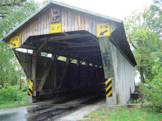
Photo: Chefpyromaniac, via Wikimedia Commons, CC BY-SA 3.0 · Wikimedia Commons
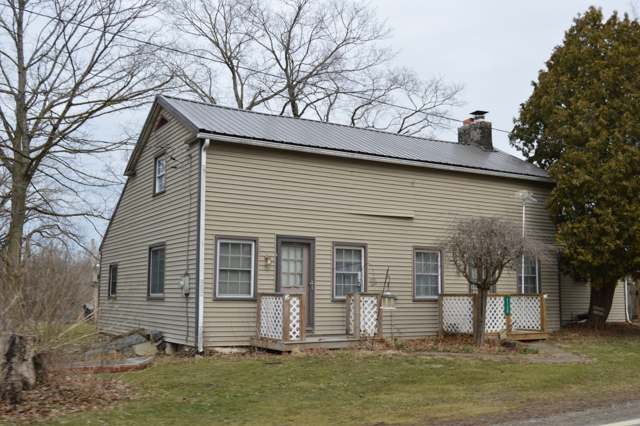
Photo: Nyttend, public domain · Wikimedia Commons
Local history sources: dn710906.ca.archive.org · en.wikipedia.org · en.wikipedia.org · en.wikipedia.org · delcowater.org · commons.wikimedia.org · commons.wikimedia.org · en.wikipedia.org
Water
Del-Co's East Knox wellfield at Bryant and Lucerne Rds, Wayne Twp, about 5 miles WSW of Fredericktown The water here
- Del-co Water Company, Inc.100% of residentsOlentangy River, O'Shaughnessy and Alum Creek reservoirs, plus Knox County wells
Its ZIP codes
Each ZIP code that touches Porter Township, Delaware County, with the share of its residents who live here and the same headline figures as the ZIP page.
| ZIP | Share | Water | Radon | Home value | Schools | Flood |
|---|---|---|---|---|---|---|
| 43011 Hilliar Township and Centerburg | 9% | Del-Co's East Knox wellfield at Bryant and Lucerne Rds, Wayne Twp, about 5 miles WSW of Fredericktown | 8.2 pCi/L average radon | Median year built 1988 | Centerburg Local · 3.5 stars overall | 0.9% of residents in the 1% floodplain |
| 43074 Sunbury | 9% | Alum Creek Reservoir intake at the Scott plant, Lewis Center Rd at Africa, Orange Township | 5.3 pCi/L average radon | Parcel list only | Big Walnut Local · 4 stars overall | 2.9% of residents in the 1% floodplain |
| 43334 Bennington Township and Marengo | 3% | Del-Co's East Knox wellfield at Bryant and Lucerne Rds, Wayne Twp, about 5 miles WSW of Fredericktown | 6.4 pCi/L average radon | Median year built 1993 | Highland Local · 3.5 stars overall | 1.3% of residents in the 1% floodplain |
The county
Delaware County: 11 ZIP codes, 26 cities, villages and townships, 214,126 people.
Nearby places
Cite this page
Cite this page as:
Cracked Buckeye (Open Shower Co), "Porter Township, Delaware County", https://crackedbuckeye.com/place/porter-township-delaware-county/, built 2026-09-16, accessed [date].
Machine-readable: /api/place/porter-township-delaware-county.json (open JSON, CC BY 4.0 for the compilation; the underlying records keep their own terms) · How to cite · Report a correction · Built 2026-09-16