Local events in Perry Township, Muskingum County
Nothing is posted for Perry Township itself yet; here is what is on within 10 miles. All local events in Perry Township, Muskingum County
Know a calendar we should watch? Send the link
Checked October 20; the events page is refreshed daily.
How Perry Township, Muskingum County began
Perry Township, in the east-central part of Muskingum County, was established in 1812 and named for naval officer Oliver Hazard Perry (1785-1819), whose 1813 victory at the Battle of Lake Erie made him a national hero. By the 1830s the township supported three churches, four flouring mills and five sawmills, a typical mix for an early Ohio farm township along its streams. It has no incorporated municipality; its best-known landmark is the Salt Creek Covered Bridge, a Warren-truss span built in 1876 northwest of Norwich.
Settled 1802 (James Brown Sr., who built a cabin and tavern where Zane's Trace crossed Big Salt Creek), incorporated 1812, by organized in 1812 and named for Commodore Oliver H. Perry, according to Everhart's 1882 county history.
Where the name comes from
The 1882 county history says Perry Township was organized in 1812 and named in honor of Commodore Oliver H. Perry. Perry's victory on Lake Erie came in September 1813, a year after the date the history gives for the township's organization, so either the date or the reason for the name is uncertain; the record does not settle it.
Before the town
No Native American sites or named villages specific to Perry Township is recorded. The township lies within the area opened to settlement by the 1795 Treaty of Greenville; Wyandot and Delaware (Lenape) people are documented living, hunting and traveling in the wider Zanesville area of Muskingum County in the same period through their friendships with early settler Jonathan Zane and his family. A county-level file, if written, should carry the fuller regional record; nothing site-specific has been verified for this township's own ground.
Timeline
- — James Brown Sr. (sometimes called Luke Brown), from Massachusetts, builds the township's first cabin and opens a tavern where the Zane Trace, or Old Wheeling Road, crosses Big Salt Creek; the road enters the township on section 20 and the first settlements are made along it.
- — David Comstock settles on the southeast quarter of section 18; Abraham Gabriel and his son Reuben follow in 1807, buying 500 acres of the Johnson four-thousand-acre purchase.
- — Christopher Shuck builds the township's first saw and grist mills for Jacob Livingood on Salt Creek just below the later National Pike crossing; John Warrenbee builds a small sawmill on Salt Creek in 1809 and a gristmill in 1812.
- — Abraham Gabriel dies, the first death in the township, and is buried on what became George Orr's place; a Methodist class meets at John Bowers's house from about 1808, the origin of Wesley Chapel.
- — Alexander Armstrong from Armagh, Ireland, settles on the Wheeling road, with Jacob Vanpelt, Simon Merwine, Philip Baker, Christopher Schuch and James Brown Jr. also arriving; Major James Brown keeps a second tavern on the road.
- — Simon Merrill teaches the first school, in a log cabin with a puncheon floor on the Comstock place, and Jacob Wisecarver is the first blacksmith, near the site of Sonora.
- — Perry Township is organized and named for naval officer Oliver Hazard Perry.
- — Eli Walls builds the first brick building in the township; Mr. Kaufman builds the next in 1820.
- — The National Pike, the only pike in the township, is completed through it from section 11 westward.
- — The township is recorded as having three churches, four flouring mills and five sawmills.
- — Andrew Hughes, who lived near the bridge on the National Road, is appointed first postmaster of the new Bridgeville post office, from which the hamlet of Bridgeville takes its start.
- — Isaac Stiers lays out Sonora on land of John Brown; its first house is Solomon Bowers's hotel, later Dunn's, and the post office opens in 1855 with Evan Crane as first postmaster.
- — The Salt Creek Covered Bridge, a Warren-truss span over Big Salt Creek northwest of Norwich, is built.
- — Sonora, a station and water tank on the Central Ohio Division of the Baltimore & Ohio Railroad, has twenty-one dwellings, about one hundred inhabitants, two stores, a hotel and a broom factory.
- — The Salt Creek Covered Bridge is listed on the National Register of Historic Places on September 10.
- — The census counts 2,728 people in the township.
Stories
A bridge that outlasted its mills
Where Perry Township's 1830s economy ran on four flour mills and five sawmills turning the power of local streams, almost none of that milling infrastructure survives today. What does survive is the Salt Creek Covered Bridge, a wooden Warren-truss span built in 1876 across Big Salt Creek about three miles northwest of Norwich, on what was then Arch Hill Road. The National Park Service's Historic American Engineering Record documented the bridge's stone abutments, its interior truss panels and the stenciled names of the local donors who helped pay for it — an ordinary rural bridge that became one of the township's few 19th-century structures to reach the National Register, listed in 1974.
Named for a hero, not a settler
Perry Township took its name in 1812 not from any local pioneer but from Commodore Oliver Hazard Perry, whose 1813 victory over the British fleet on Lake Erie made him one of the young republic's most celebrated figures. Ohio named dozens of townships, towns and a whole county after Perry in the years following the War of 1812; this Muskingum County township, laid out the same year the war began, was one of them, formalizing its own local government just as the conflict with Britain that would make Perry famous was getting underway.
A tavern on the Zane Trace
The first home in Perry Township was a log cabin that James Brown Sr., a man of means and unusual intelligence from Massachusetts, built in 1802 where the Zane Trace, also called the Old Wheeling Road, crossed Big Salt Creek. He opened a hotel there and, the county history says, offered no small opposition to Isaac Pryor, who kept a hotel farther west on the same highway. Along this road the first settlements were made: David Comstock in 1804, Abraham Gabriel and his son Reuben from Franklin County, Pennsylvania, in 1807, and Alexander Armstrong from Armagh, Ireland, in 1810, so that the old roadway served as the township's main street until the National Pike was finished in 1829. Brown's son, Major James Brown, kept another tavern on the road from 1810. Abraham Gabriel's death in 1808 was the first in the township, and the first school, taught by Simon Merrill in 1811, was a log cabin with a puncheon floor on the Comstock place.
Photographs
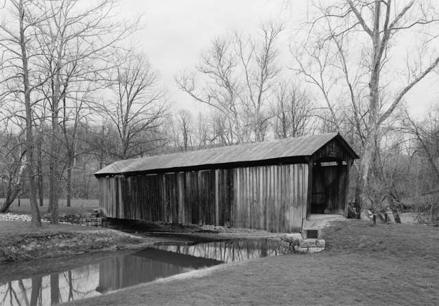
Photo: Jet Lowe, U.S. Department of the Interior, National Park Service, Historic American Engineering Record (HAER OH-127-3), public domain · Wikimedia Commons
Local history sources: en.wikipedia.org · commons.wikimedia.org · en.wikipedia.org · muskingumcountyhistory.org · archive.org
Historic places
1 place in Perry Township, Muskingum County on the National Register of Historic Places. Press a pin or a name for its whole record.
-
Salt Creek Covered BridgeStructure · Norwich · listed 1974
- Address
- 3 mi. NW of Norwich
- Where
- Norwich, Muskingum County · ZIP 43701
- What it is
- Structure
- Listed on the National Register
- 1974
- NRIS reference number
- 74001587
- Coordinates
- 39.99876, -81.83978
National Register file (NPS) ↗ Search Wikipedia ↗ Street map and directions ↗ On the Cracked Buckeye map
Source: National Park Service, National Register of Historic Places point file. The listing year is shown where NPS's certification date agrees with the listing's reference number. Listing recognizes significance; it does not restrict a private owner.
Water
Mostly private wells The water here
- Zanesville66% of residentsMuskingum River valley aquifer (wells)
- Muskingum County Water - Se22% of residentsMuskingum River buried valley aquifer (wells near Duncan Falls)
- South Zanesville6% of residentsGroundwater wells (2 wells)
- Maysville Regional Water5% of residentsMuskingum River buried valley aquifer (wells near Duncan Falls)
- Greenlawn Estates MHP1% of residentsMuskingum River buried valley aquifer (wells near Duncan Falls)
Hospitals, fire stations and more
Inside Perry Township, Muskingum County's boundary: 1 fire or EMS station, 1 public school, 1 poor-rated bridge, 1 public charging site, 2 shale and injection wells, 2 Toxics Release Inventory facilities and 14 spill cases. Press a pin or a name for its whole record and its source.
Fire and EMS stations (1)
-
Perry Township Fire DepartmentZanesville
- Address
- 4625 Boggs Road, Zanesville, OH 43701
- Coordinates
- 39.97077, -81.90464
USGS National Map structures (source) ↗ Street map and directions ↗
Source: USGS National Map structures (most Ohio records last updated 2019 to 2022), checked against the Columbus and Cleveland station lists. The department that answers a call is set by jurisdiction and mutual aid, not by distance.
Public schools (1)
-
Perry Elementary School2.5 of 5 stars · Zanesville
- Address
- 6975 East Pike, Zanesville, OH 43701
- School district
- East Muskingum Local School District
- Kind (NCES)
- Regular School
- Students, 2023-24
- 117
- Teachers (full-time equivalent)
- 6.75
- Report card, 2025-26
- 2.5 of 5 stars
- Ohio building IRN
- 029678
- NCES school ID
- 390488303418
NCES school record ↗ Ohio School Report Card ↗ Street map and directions ↗
Source: NCES EDGE public school locations 2024-25 and Common Core of Data 2023-24 (type, students, teachers); Ohio School Report Cards 2025-26 (Department of Education and Workforce), matched by name within the district.
Bridges rated poor (1)
-
Carr Road over Salt Creek TributaryPoor · built 1900
- Condition
- Poor: a deck, superstructure, substructure or culvert rated 4 or below on the 0 to 9 scale
- What it is
- Bridge
- Built
- 1900
- Length
- 8 ft
- Owner
- County
- Vehicles a day
- 209
- Coordinates
- 40.00123, -81.82558
National Bridge Inventory (source) ↗ Street map and directions ↗
Source: FHWA National Bridge Inventory 2025. "Poor" means one major part rated 4 or below on the 0 to 9 scale; it calls for repair, not closing, unless the state posts or closes the bridge.
Public EV charging (1)
-
Best Western - Zanesville DC fast4 DC fast · Zanesville
- Address
- 4929 E Pike, Zanesville, OH 43701
- Ports
- 4 DC fast
- Plugs
- CCS
- Network
- FCN
- Hours
- 24 hours daily
- Phone
- 800-489-1588
Station Locator (NREL) ↗ Alternative Fuels Data Center (source) ↗ Street map and directions ↗
Source: NREL Alternative Fuels Data Center station list (May 2026), public and open stations, the posts at one address counted as one site.
Shale and injection wells (2)
-
Pattison Trust (Swiw #30) 1-D InjectionInjection well (Class II)
- What it is
- Injection well (Class II)
- Operator
- Force Environmental Solutions Llc
- County
- Muskingum County
- API well number
- 34119288030000
- Coordinates
- 39.97371, -81.82558
ODNR oil and gas wells (source) ↗ Street map and directions ↗
-
Roland & Marilyn Kemble (Swiw #28) 1-D InjectionInjection well (Class II)
- What it is
- Injection well (Class II)
- Operator
- Spirit Services of Ohio Llc
- County
- Muskingum County
- API well number
- 34119287800000
- Coordinates
- 39.97503, -81.84524
ODNR oil and gas wells (source) ↗ Street map and directions ↗
Source: ODNR Division of Oil and Gas Resources well inventory (September 2026): drilled Utica, Marcellus and horizontal wells and Class II injection wells not plugged. Older vertical wells are on the full map.
Facilities reporting toxic releases (2)
-
All American Homes of Ohio L L CToxics Release Inventory · Zanesville
- Address
- 4005 All American Way, Zanesville, OH 43701
- County
- Muskingum County
- Status
- Reports to the Toxics Release Inventory (active)
- EPA program ID
- 43701LLMRC4005A
- EPA registry ID
- 110012251204
EPA facility record ↗ EPA Facility Registry Service (source) ↗ Street map and directions ↗
-
Plaskolite IncToxics Release Inventory · Zanesville
- Address
- 1175 5-B's Dr, Zanesville, OH 43701
- County
- Muskingum County
- Status
- Reports to the Toxics Release Inventory (active)
- EPA program ID
- 43701PLSKL11755
- EPA registry ID
- 110041374063
EPA facility record ↗ EPA Facility Registry Service (source) ↗ Street map and directions ↗
Source: EPA Facility Registry Service, Toxics Release Inventory reporters. Reporting a release is required of large users of listed chemicals; it is not by itself a violation.
Spills reported since 2021 (14)
-
Anhydrous Ammonia (Nh3)2025-06-27 · Perry Twp
- Reported
- 2025-06-27
- What spilled
- Anhydrous Ammonia (Nh3)
- Where
- Perry Twp, Muskingum County
- Ohio EPA district office
- SEDO
- Ohio EPA case number
- 2506EPA0001076
Ohio EPA spill reports (source) ↗ Street map and directions ↗
-
Pesticide(S) Nos (Not Specified)2025-05-12 · Highland Twp
- Reported
- 2025-05-12
- What spilled
- Pesticide(S) Nos (Not Specified)
- Largest amount reported
- 120 gallons
- Where
- Highland Twp, Muskingum County
- Ohio EPA district office
- SEDO
- Ohio EPA case number
- 2505EPA0000751
Ohio EPA spill reports (source) ↗ Street map and directions ↗
-
Fuel Diesel / Diesel Fuel (Vehicle On Or Off Road)2025-02-26 · Perry Twp
- Reported
- 2025-02-26
- What spilled
- Fuel Diesel / Diesel Fuel (Vehicle On Or Off Road)
- Largest amount reported
- 100 gallons
- Where
- Perry Twp, Muskingum County
- Ohio EPA district office
- SEDO
- Ohio EPA case number
- 2502EPA0000260
Ohio EPA spill reports (source) ↗ Street map and directions ↗
-
Other / All Other / Trade Name / Mixture / Solution Etc2024-09-18 · Perry Twp
- Reported
- 2024-09-18
- What spilled
- Other / All Other / Trade Name / Mixture / Solution Etc
- Where
- Perry Twp, Muskingum County
- Ohio EPA district office
- SEDO
- Ohio EPA case number
- 2409EPA0001598
Ohio EPA spill reports (source) ↗ Street map and directions ↗
-
Fuel Diesel / Diesel Fuel (Vehicle On Or Off Road)2024-04-15 · Perry Twp
- Reported
- 2024-04-15
- What spilled
- Fuel Diesel / Diesel Fuel (Vehicle On Or Off Road)
- Largest amount reported
- 100 gallons
- Where
- Perry Twp, Muskingum County
- Ohio EPA district office
- SEDO
- Ohio EPA case number
- 2404EPA0000625
Ohio EPA spill reports (source) ↗ Street map and directions ↗
-
Oil Crude2022-09-28 · Perry Twp
- Reported
- 2022-09-28
- What spilled
- Oil Crude
- Where
- Perry Twp, Muskingum County
- Ohio EPA district office
- SEDO
- Ohio EPA case number
- 2209EPA0001485
Ohio EPA spill reports (source) ↗ Street map and directions ↗
-
Orphan Drum(S)2022-09-27 · Perry Twp
- Reported
- 2022-09-27
- What spilled
- Orphan Drum(S)
- Largest amount reported
- 275 gallons
- Where
- Perry Twp, Muskingum County
- Ohio EPA district office
- SEDO
- Ohio EPA case number
- 2209EPA0001483
Ohio EPA spill reports (source) ↗ Street map and directions ↗
-
Sheen Rainbow / Hydrocarbon2022-04-14 · Perry Twp
- Reported
- 2022-04-14
- What spilled
- Sheen Rainbow / Hydrocarbon
- Where
- Perry Twp, Muskingum County
- Ohio EPA district office
- SEDO
- Ohio EPA case number
- 2204EPA0000510
Ohio EPA spill reports (source) ↗ Street map and directions ↗
-
Anhydrous Ammonia (Nh3)2022-03-20 · Perry Twp
- Reported
- 2022-03-20
- What spilled
- Anhydrous Ammonia (Nh3)
- Where
- Perry Twp, Muskingum County
- Ohio EPA district office
- SEDO
- Ohio EPA case number
- 2203EPA0000372
Ohio EPA spill reports (source) ↗ Street map and directions ↗
-
Oil Motor / Lube Oil / Vehicle2021-09-01 · Perry Twp
- Reported
- 2021-09-01
- What spilled
- Oil Motor / Lube Oil / Vehicle
- Where
- Perry Twp, Muskingum County
- Ohio EPA district office
- SEDO
- Ohio EPA case number
- 2109EPA0001387
Ohio EPA spill reports (source) ↗ Street map and directions ↗
-
Battery Acid (Dilute Sulfuric) Reached water2021-07-20 · Perry Twp
- Reported
- 2021-07-20
- What spilled
- Battery Acid (Dilute Sulfuric)
- Reached a waterway
- 99 - Unnamed
- Where
- Perry Twp, Muskingum County
- Ohio EPA district office
- SEDO
- Ohio EPA case number
- 2107EPA0001090
Ohio EPA spill reports (source) ↗ Street map and directions ↗
-
Fuel Diesel / Diesel Fuel (Vehicle On Or Off Road) Reached water2021-03-17 · Perry Twp
- Reported
- 2021-03-17
- What spilled
- Fuel Diesel / Diesel Fuel (Vehicle On Or Off Road)
- Reached a waterway
- 99 - Unnamed
- Where
- Perry Twp, Muskingum County
- Ohio EPA district office
- SEDO
- Ohio EPA case number
- 2103EPA0000351
Ohio EPA spill reports (source) ↗ Street map and directions ↗
-
Fuel Diesel / Diesel Fuel (Vehicle On Or Off Road)2021-01-30 · Perry Twp
- Reported
- 2021-01-30
- What spilled
- Fuel Diesel / Diesel Fuel (Vehicle On Or Off Road)
- Largest amount reported
- 100 gallons
- Where
- Perry Twp, Muskingum County
- Ohio EPA district office
- SEDO
- Ohio EPA case number
- 2101EPA0000133
Ohio EPA spill reports (source) ↗ Street map and directions ↗
-
Fuel Diesel / Diesel Fuel (Vehicle On Or Off Road)2026-01-23 · Perry Twp
- Reported
- 2026-01-23
- What spilled
- Fuel Diesel / Diesel Fuel (Vehicle On Or Off Road)
- Where
- Perry Twp, Muskingum County
- Ohio EPA district office
- SEDO
- Ohio EPA case number
- 2601EPA0000086
Ohio EPA spill reports (source) ↗ Street map and directions ↗
Source: Ohio EPA emergency response spill reports, 2021 to September 2026, one point per case where Ohio EPA placed it. A report is what the caller or responder recorded; amounts are often blank or estimated.
Its ZIP codes
Each ZIP code that touches Perry Township, Muskingum County, with the share of its residents who live here and the same headline figures as the ZIP page.
| ZIP | Share | Water | Radon | Home value | Schools | Flood |
|---|---|---|---|---|---|---|
| 43767 Union Township and Norwich | 7% | Mostly private wells | 10.0 pCi/L average radon | Appraisal records without year built | East Muskingum Local · 3.5 stars overall | 0.0% of residents in the 1% floodplain |
| 43701 Zanesville | 5% | Wells in the eastern floodplain of the Muskingum River along Lewis Drive/SR 666 (Riverside Park well field, reportedly in use since about 1917), adjacent to the treatment plant on Buckeye Drive | 6.5 pCi/L average radon | Appraisal records without year built | Zanesville City · 3 stars overall | 1.2% of residents in the 1% floodplain |
Local government
Who holds office in Perry Township, Muskingum County, how its elections and ballot issues came out, and the state auditor's record.
Money issues on the ballot since 2017: 1 of 3 passed.
Ballot issues
| Date | Issue | For | Against | Result |
|---|---|---|---|---|
| 2020-03-17 | Issue: Perry Fire renewal 3 mil 5 yrs (3.0 mills, renewal) | 0 | 0 | Failed |
| 2018-05-08 | Issue: Perry Fire 3.5 mill 5 yrs New (3.5 mills) | 397 | 261 | Passed (60.33% for) |
| 2017-11-07 | Issue: Perry Twp Fire, 3.5 mills 5 yrs New (3.5 mills) | 342 | 392 | Failed (46.59% for) |
Elections for office
| Date | Office | Candidates and votes |
|---|---|---|
| 2021-11-02 | Trustee | David Danison 274, 52.39%; Gary L. Hursey 249, 47.61% |
| 2019-11-05 | Trustee | Doug West 470, 100.0% |
| 2019-11-05 | Fiscal Officer | Rick B. Alexander 361, 100.0% |
Winners in bold. Results from the county board of elections' official canvass unless marked.
Auditor of State record
- No fiscal caution, watch or emergency on the Auditor of State's lists.
- Agreed Upon Procedures, 2022 to 2023, released 2025-03-18
The county
Muskingum County: 17 ZIP codes, 38 cities, villages and townships, 91,875 people.
Nearby places
Quick answers
What county is Perry Township, Ohio in?
Perry Township, Muskingum County is a township in Muskingum County, Ohio, with 2,714 residents.
When was Perry Township, Ohio founded?
Perry Township, Muskingum County was settled 1802 (James Brown Sr., who built a cabin and tavern where Zane's Trace crossed Big Salt Creek); incorporated 1812. Founders on record: organized in 1812 and named for Commodore Oliver H. Perry, according to Everhart's 1882 county history. Source
How did Perry Township, Ohio get its name?
The 1882 county history says Perry Township was organized in 1812 and named in honor of Commodore Oliver H. Source
What ZIP code is Perry Township, Ohio?
Perry Township, Muskingum County is served by ZIP codes 43767 and 43701; 43767 holds the largest share of its residents.
Where does Perry Township, Ohio get its water?
The main water source for Perry Township, Muskingum County (Zanesville): Mostly private wells.
Cite this page
Cite this page as:
Cracked Buckeye, "Perry Township, Muskingum County", https://crackedbuckeye.com/place/perry-township-muskingum-county/, built 2026-10-31, accessed [date].
How to cite · Report a correction · Built 2026-10-31
