Local events in Olive Township, Meigs County
Nothing is posted for Olive Township itself yet; here is what is on within 20 miles. All local events in Olive Township, Meigs County
Know a calendar we should watch? Send the link
Checked October 20; the events page is refreshed daily.
How Olive Township, Meigs County began
Olive Township occupies Meigs County's northeastern corner, the farthest upstream of the county's Ohio River townships, set off from Athens County territory in 1819 as Meigs County itself was created. It has no incorporated village of its own; instead it holds three unincorporated river and inland communities -- Long Bottom in the south, Reedsville on the shoreline, and Tuppers Plains in the northwest -- each with its own small pioneer-era founding story built on timber, milling and small trade rather than a courthouse or a railroad. Long Bottom's earliest settlers, the Rairdon and Colman families, arrived probably before 1800. Today the township is rural and thinly populated, 1,651 residents in the 2020 census, and its water history in recent years has been dominated by the Tuppers Plains-Chester Water District's fight against Ohio River flooding and PFAS ('forever chemical') contamination.
Settled probably before 1800 (Long Bottom, by the Rairdon and Colman families), incorporated 1819 (set off from Athens County as Meigs County is formed).
Where the name comes from
No known source we consulted explains why the township is named Olive. Statewide, the only other Olive Township in Ohio is in Noble County; no known document connects either township's name to a specific person or place.
Before the town
No source we consulted documents a specific Native American village, camp, trail or burial site within Olive Township. The township's stretch of the Ohio River, across from Wood County and Jackson County, West Virginia, lay within territory the United States treated as ceded by the Treaty of Fort McIntosh (1785) and Treaty of Fort Harmar (1789) -- agreements the Shawnee and Miami disputed -- confirmed to the Americans' satisfaction only by the Treaty of Greenville in 1795. Nothing site-specific to Olive Township is recorded here, and the gap should be read plainly rather than filled with a guess.
Nations recorded here: Shawnee, Wyandot, Mingo (Seneca-Cayuga).
Timeline
- — Thomas Rairdon and the Colman families become the earliest documented settlers at Long Bottom, in the southern part of what becomes Olive Township; the exact date is not known.
- — William Buffington purchases land at Long Bottom, followed soon after by the Whiteside and Collins families.
- — Thomas Rairdon builds Long Bottom's first grist mill; the same year, the settlement's first post office opens on the Warner farm with Robert Collins as postmaster.
- — Olive Township is set off from Athens County territory as Meigs County is formed.
- — John Roberts and William Hicks open Long Bottom's first store, near the mouth of Forked Run.
- — A Methodist Church is established at Long Bottom, followed by a Christian Church congregation in 1847.
- — The Tuppers Plains-Chester Water District is created December 31 as a nonprofit government entity under Ohio Revised Code Chapter 6119, formed to serve rural residents including those in Olive Township's Tuppers Plains community.
- — The Ohio River crests above 41 feet on April 5, putting part of the district's Long Bottom wellfield underwater; a raw, untreated sample taken the next day tests positive for E. coli, and customers are placed under a boil advisory.
- — Ohio EPA announces on April 7 that the Tuppers Plains-Chester Water District will receive $4 million from a $65 million DuPont PFAS settlement distribution to extend waterlines to homeowners with PFOA-contaminated private wells.
Stories
A mill, a post office, and casks by the riverful
Long Bottom's earliest years followed a pattern common to Ohio River bottomlands: settlers first, infrastructure later. The Rairdon and Colman families had put down roots probably before 1800, though the exact year was already lost to memory when the county's pioneer historians went looking for it decades later. William Buffington bought in around 1808, and by 1815 the little settlement had both a working grist mill, built by Thomas Rairdon himself, and its first post office, on the Warner farm with Robert Collins as postmaster. It took until 1839 for the place to get an actual store, when John Roberts and William Hicks opened one near where Forked Run empties into the Ohio. What really drove the local economy, though, was the forest itself: Long Bottom's leading business for much of its early history was turning its heavy timber into staves and casks, barrel-making for a river trade that needed containers by the thousand.
A wellfield underwater, twice over
The Tuppers Plains-Chester Water District, formed in 1966 to bring reliable water to the rural stretch of Meigs and Athens counties around Olive Township, draws from six wells, including a wellfield at Long Bottom -- low bottomland the Ohio River has flooded before. On April 5, 2024, the river crested above 41 feet and put part of that wellfield underwater; a raw sample pulled the next morning tested positive for E. coli, and the district had to warn its customers to boil their water. Two years later, in April 2026, the district's water made news for the opposite kind of contamination: Ohio EPA announced it would receive $4 million of a $65 million DuPont PFAS settlement to run new waterlines out to homeowners whose private wells carry PFOA, the 'forever chemical' that reached the region's groundwater from DuPont's Washington Works plant in Parkersburg, West Virginia.
Photographs
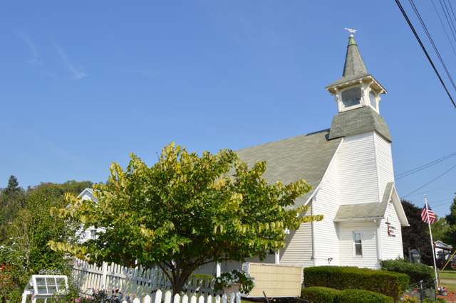
Photo: Nyttend, public domain · Wikimedia Commons
Local history sources: en.wikipedia.org · meigs.ohgenweb.org · en.wikipedia.org · tpcwd.org · athensmessenger.com · wsaz.com · commons.wikimedia.org
Water
Local groundwater wells in the Ohio River valley near Long Bottom The water here
- Tuppers Plains/chester Water District93% of residentsLocal groundwater wells near Long Bottom (Ohio River valley area)
- Little Hocking Water Association, Inc.4% of residentsOhio River Valley Aquifer (own wells, Porterfield wellfield)
- Coolville Village3% of residentsLocal groundwater wells near Long Bottom (Ohio River valley area)
Hospitals, fire stations and more
Inside Olive Township, Meigs County's boundary: 1 fire or EMS station, 1 high-hazard dam, 1 shale or injection well and 3 spill cases. Press a pin or a name for its whole record and its source.
Fire and EMS stations (1)
-
Olive Township Volunteer Fire Department and Emergency Medical ServicesReedsville
- Address
- 38677 Firehouse Drive, Reedsville, OH 45772
- Coordinates
- 39.11889, -81.74906
USGS National Map structures (source) ↗ Street map and directions ↗
Source: USGS National Map structures (most Ohio records last updated 2019 to 2022), checked against the Columbus and Cleveland station lists. The department that answers a call is set by jurisdiction and mutual aid, not by distance.
High-hazard dams (1)
-
Forked Run Lake Dam PoorForked Run · condition: poor
- Hazard class
- High: a failure would probably cost a life
- Condition
- Poor (assessed 06/16/2023)
- River or stream
- Forked Run
- Purpose
- Recreation
- Type
- Earth
- Height
- 56 ft
- Storage
- 2,785 acre-feet
- Completed
- 1952
- Owner type
- State
- County
- Meigs County
- Nearest town (NID)
- Long Bottom
- Last inspection
- 05/25/2022
- Emergency action plan
- Yes
- NID ID
- OH00440
National Inventory of Dams record ↗ National Inventory of Dams (source) ↗ Street map and directions ↗
Source: U.S. Army Corps of Engineers National Inventory of Dams, August 2026. "High hazard" rates what a failure would cost downstream, not how likely one is; the condition is the state's assessment.
Shale and injection wells (1)
-
C.L. & Robert Craft {Swiw#9} 249 InjectionInjection well (Class II)
- What it is
- Injection well (Class II)
- Operator
- Mountaineer State Operations Llc
- County
- Meigs County
- API well number
- 34105224610000
- Coordinates
- 39.16039, -81.84125
ODNR oil and gas wells (source) ↗ Street map and directions ↗
Source: ODNR Division of Oil and Gas Resources well inventory (September 2026): drilled Utica, Marcellus and horizontal wells and Class II injection wells not plugged. Older vertical wells are on the full map.
Spills reported since 2021 (3)
-
Oil Hydraulic Fluid(S)2025-02-24 · Olive Twp
- Reported
- 2025-02-24
- What spilled
- Oil Hydraulic Fluid(S); Fuel Diesel / Diesel Fuel (Vehicle On Or Off Road)
- Where
- Olive Twp, Meigs County
- Ohio EPA district office
- SEDO
- Ohio EPA case number
- 2502EPA0000248
Ohio EPA spill reports (source) ↗ Street map and directions ↗
-
Orphan Drum(S)2024-04-11 · Olive Twp
- Reported
- 2024-04-11
- What spilled
- Orphan Drum(S)
- Where
- Olive Twp, Meigs County
- Ohio EPA district office
- SEDO
- Ohio EPA case number
- 2404EPA0000594
Ohio EPA spill reports (source) ↗ Street map and directions ↗
-
Oil Motor / Lube Oil / Vehicle2021-03-05 · Olive Twp
- Reported
- 2021-03-05
- What spilled
- Oil Motor / Lube Oil / Vehicle
- Where
- Olive Twp, Meigs County
- Ohio EPA district office
- SEDO
- Ohio EPA case number
- 2103EPA0000290
Ohio EPA spill reports (source) ↗ Street map and directions ↗
Source: Ohio EPA emergency response spill reports, 2021 to September 2026, one point per case where Ohio EPA placed it. A report is what the caller or responder recorded; amounts are often blank or estimated.
Its ZIP codes
Each ZIP code that touches Olive Township, Meigs County, with the share of its residents who live here and the same headline figures as the ZIP page.
| ZIP | Share | Water | Radon | Home value | Schools | Flood |
|---|---|---|---|---|---|---|
| 45783 Olive Township and Tuppers Plains | 70% | Local groundwater wells in the Ohio River valley near Long Bottom | Too few radon tests | No homes in the parcel records | Eastern Local · 3 stars overall | 0.0% of residents in the 1% floodplain |
| 45772 Olive Township and Reedsville | 66% | Mostly private wells | Too few radon tests | No homes in the parcel records | Eastern Local · 3 stars overall | 2.6% of residents in the 1% floodplain |
| 45743 Chester Township and Long Bottom | 24% | Mostly private wells | Too few radon tests | No homes in the parcel records | Eastern Local · 3 stars overall | 9.8% of residents in the 1% floodplain |
| 45723 Troy Township and Coolville | 2% | Mostly private wells | 1.9 pCi/L average radon | Median year built 1973 | Federal Hocking Local · 3 stars overall | 3.5% of residents in the 1% floodplain |
Local government
Who holds office in Olive Township, Meigs County, how its elections and ballot issues came out, and the state auditor's record.
Money issues on the ballot since 2019: 2 of 3 passed; of those asking for new or higher taxes, 0 of 1.
Ballot issues
| Date | Issue | For | Against | Result |
|---|---|---|---|---|
| 2026-05-05 | Issue: Tax Levy - Additional - Olive Township - Cemeteries - 1.5 mills / 5 yrs (1.5 mills, additional) | 132 | 173 | Failed (43.28% for), unofficial |
| 2021-11-02 | Issue: Olive Twp. Cemetery Levy Renewal - 1mill/5yrs (1.0 mills, renewal) | 210 | 54 | Passed (79.55% for) |
| 2020-03-17 | Issue: Local Liquor By Petition Option Olive Township | 116 | 52 | Passed (69.05% for) |
| 2019-11-05 | Issue: Olive TWP 1.5 Mill Ren Fire Protection (1.5 mills) | 290 | 66 | Passed (81.46% for) |
Elections for office
| Date | Office | Candidates and votes |
|---|---|---|
| 2021-11-02 | Township Trustee | Larry E. Life 201, 51.94%; William R. Osborne 186, 48.06% |
| 2019-11-05 | Township Trustee | Randy Boston 306, 100.0% |
| 2019-11-05 | Township Fiscal Officer | Kelly A. Epling 183, 52.29%; Kaleen Hayman 167, 47.71% |
Winners in bold. Results from the county board of elections' official canvass unless marked.
Auditor of State record
- No fiscal caution, watch or emergency on the Auditor of State's lists.
- Financial Audit, 2022 to 2023, released 2024-08-27
The county
Meigs County: 12 ZIP codes, 16 cities, villages and townships, 20,189 people.
Nearby places
Quick answers
What county is Olive Township, Ohio in?
Olive Township, Meigs County is a township in Meigs County, Ohio, with 1,642 residents.
When was Olive Township, Ohio founded?
Olive Township, Meigs County was settled probably before 1800 (Long Bottom, by the Rairdon and Colman families); incorporated 1819 (set off from Athens County as Meigs County is formed). Source
How did Olive Township, Ohio get its name?
No known source we consulted explains why the township is named Olive. Source
What ZIP code is Olive Township, Ohio?
Olive Township, Meigs County is served by ZIP codes 45783, 45772 and 45743; 45783 holds the largest share of its residents.
Where does Olive Township, Ohio get its water?
The main water source for Olive Township, Meigs County (Tuppers Plains/chester Water District): Local groundwater wells in the Ohio River valley near Long Bottom.
Cite this page
Cite this page as:
Cracked Buckeye, "Olive Township, Meigs County", https://crackedbuckeye.com/place/olive-township-meigs-county/, built 2026-10-31, accessed [date].
How to cite · Report a correction · Built 2026-10-31
