Local events in Coolville
Nothing is posted for Coolville itself yet; here is what is on within 20 miles. All local events in Coolville
Know a calendar we should watch? Send the link
Checked October 20; the events page is refreshed daily.
How Coolville began
Coolville, in Troy Township in southeastern Athens County, began in 1814 when Simeon W. Cooley and his son Heman built a mill on the west bank of the Hockhocking, five miles above its mouth; Cooley laid out the town in 1818. The 1869 county history says it was incorporated in 1855 (Wikipedia says 1835) and had about 300 people, three churches, two district schools and a seminary. It grew as a farm-trade village rather than an industrial one; its population peaked at 672 in 1970 and was 454 in 2020. The PFOA contamination tied to DuPont's Washington Works belongs chiefly to Little Hocking, not to Coolville.
Settled 1814 (Simeon W. Cooley and son Heman, who built a mill), platted 1818, incorporated 1855 per the 1869 county history; 1835 per Wikipedia, by Simeon W. Cooley.
Where the name comes from
Coolville is named for Simeon W. Cooley, who began the settlement in 1814 with his son Heman and laid out the town in 1818; the spelling shifted from Cooleyville toward Coolville.
Before the town
No source specific to Coolville or the immediate river landing was found describing a named Native village, trail, or mound at this site. At the county level, Walker's 1869 History of Athens County records ancient mounds and an earthwork/fortification on 'the Plains' in Athens and Dover townships (skeletons, stone hatchets and weapons recovered), states that the Shawnee (Shawanese) held the Athens County region as part of the wider Scioto-Miami country, with Wyandot and Lenape (Delaware) parties frequently present on hunting and war expeditions, and describes a 1774 fortification, Fort Gower, built at the mouth of the Hocking River during Lord Dunmore's campaign, with army detachments traditionally said to have camped at Federal Creek and Sunday Creek elsewhere in the county. None of this is sited specifically at Coolville; treat it as county-wide context, not a claim about this river landing.
Nations recorded here: Shawnee, Wyandot, Lenape (Delaware).
- Fort Gower (camp) — mouth of the Hocking River, Troy Township, Athens County, 1774 (Lord Dunmore's War) (archive.org)
Timeline
- — Benajah Hoyt, probably the first white settler in Troy Township, comes from Nova Scotia to the mouth of the Hockhocking with his family.
- — A party of about forty from near Springfield, Massachusetts, who had reached Belpre in 1798, settles on the Hockhocking about seven miles from its mouth; Xerxes Paulk and Horace Parsons, Baptist preachers, are among them.
- — The first election for Troy Township officers is held at Ebenezer Buckingham's house; the township's population is 541 in 1820.
- — Simeon W. Cooley and his son Heman begin the settlement at the future Coolville by building a mill.
- — Simeon W. Cooley lays out the village that became Coolville, on the west bank of the Hockhocking River in southeastern Athens County.
- — John Frame settles at Coolville, and begins merchandising in wool, grain and produce in 1840; Dr. John Pratt, from Schuyler County, New York, settles there in 1835.
- — Coolville is formally incorporated as a village, per Wikipedia (the 1869 county history gives 1855).
- — The Roots General and Feed store was built; the building still stands, remodeled into a residence with a business front.
- — The county history describes Coolville as a pleasant village of about 300 on the west bank of the Hockhocking, with three churches, two district schools, a seminary, town hall and Masonic hall.
- — Coolville's population peaked at 672 residents.
- — Census recorded 454 residents, continuing a decline from the 1970 peak.
Stories
A town of hot and cold names
Coolville sits in a small pocket of southeastern Athens and northern Meigs counties where local place names seem to play off one another: Coolville itself, plus the unincorporated Athens County communities of Torch and Frost, and Snowville just over the line in Meigs County. None of the names are formally connected — Coolville comes from founder Simeon Cooley's surname, not the weather — but residents and local writers have long noted the coincidence as a piece of area trivia. It is one of the small oddities that distinguish an otherwise ordinary southeastern Ohio farm town.
A river town outgrown by its highway
Coolville grew up as a mill village and trade stop near what became U.S. Route 50, the road linking Athens to the Ohio River crossings toward Parkersburg, West Virginia. The village held two stores, a gristmill and a sawmill by the 1830s, a bank later in the century whose building is now the Village Hall, and the Roots General and Feed store built in 1846. When U.S. 50 was rerouted around the village in the late twentieth century, through-traffic and the trade it brought went with it, and Coolville's population fell from a 1970 peak of 672 to 454 by 2020 — a decline visible today in stretches where, as one Wikimedia Commons photograph caption puts it, 'US 50 used to run past this site.'
Dunmore's camp at the mouth of the Hockhocking
When the first Ohio Company settlers reached Troy Township in 1798 and 1799, the outline of Lord Dunmore's 1774 camping ground at the mouth of the Hockhocking was still visible: about twenty acres grown up in young saplings and underbrush, looking like an old clearing. For years afterwards settlers plowing their fields turned up hatchets, gun barrels and bullets from his army, and a rusty sword found near the roots of a fallen tree on the west side of the river ended up in the college museum at Athens. Kingman Dutton, who settled at the mouth in 1806, kept a number of canoes and pirogues to carry emigrants and their goods up the Hockhocking, since most newcomers to Athens County came down the Ohio and then ascended that river. Coolville, five miles up on the west bank, grew from a mill Simeon Cooley and his son built there in 1814.
Photographs
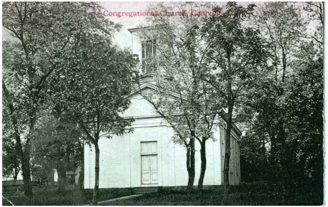
Photo: Columbus Metropolitan Library, via Digital Public Library of America / Wikimedia Commons, no known restrictions · Wikimedia Commons
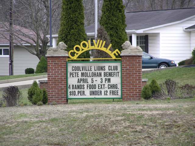
Photo: peggydavis66, via Flickr / Wikimedia Commons, CC BY-SA 2.0 · Wikimedia Commons
Local history sources: en.wikipedia.org · archive.org · en.wikipedia.org · littlehockingwater.org · littlehockingwater.org · littlehockingwater.org · commons.wikimedia.org · commons.wikimedia.org · commons.wikimedia.org · commons.wikimedia.org
Water
Mostly private wells The water here
- Little Hocking Water Association, Inc.46% of residentsOhio River Valley Aquifer (own wells, Porterfield wellfield)
- Coolville Village35% of residentsLocal groundwater wells near Long Bottom (Ohio River valley area)
- Tuppers Plains/chester Water District19% of residentsLocal groundwater wells near Long Bottom (Ohio River valley area)
Hospitals, fire stations and more
Inside Coolville's boundary: 1 health center, 1 fire or EMS station, 1 public school and 1 library. Press a pin or a name for its whole record and its source.
Community health centers (1)
-
Hopewell Health Centers - CoolvilleHealth center · Coolville
- Run by
- a federally qualified health center
- Setting
- Clinic
- City
- Coolville
- Coordinates
- 39.21738, -81.80732
Find a Health Center (HRSA) ↗ HRSA data (source) ↗ Street map and directions ↗
Source: HRSA health center service delivery sites, active, September 2026 (school-based sites left out). Health centers see patients whether or not they have insurance, with fees on a sliding scale.
Fire and EMS stations (1)
-
Coolville Fire DepartmentCoolville
- Address
- 2770 6th Street, Coolville, OH 45723
- Coordinates
- 39.22357, -81.79621
USGS National Map structures (source) ↗ Street map and directions ↗
Source: USGS National Map structures (most Ohio records last updated 2019 to 2022), checked against the Columbus and Cleveland station lists. The department that answers a call is set by jurisdiction and mutual aid, not by distance.
Public schools (1)
-
Coolville Elementary School3 of 5 stars · Coolville
- Address
- 26461 Main St, Coolville, OH 45723
- School district
- Federal Hocking Local School District
- Kind (NCES)
- Regular School
- Students, 2023-24
- 222
- Teachers (full-time equivalent)
- 18
- Report card, 2025-26
- 3 of 5 stars
- Performance index
- 79%
- Ohio building IRN
- 007302
- NCES school ID
- 390459102382
NCES school record ↗ Ohio School Report Card ↗ Street map and directions ↗
Source: NCES EDGE public school locations 2024-25 and Common Core of Data 2023-24 (type, students, teachers); Ohio School Report Cards 2025-26 (Department of Education and Workforce), matched by name within the district.
Public libraries (1)
-
Coolville BranchBranch · Coolville
- Address
- 26401 Main St, Coolville, OH 45723
- What it is
- Branch
- Library system
- Athens County Public Libraries
- Open
- 2,080 hours a year, 52 weeks
- Building
- 6,230 sq ft
- System's visits, FY2024
- 315,692
- System's loans, FY2024
- 559,090
- People the system serves
- 62,431
- Phone
- (740) 737-6036
IMLS Public Libraries Survey (source) ↗ Street map and directions ↗
Source: IMLS Public Libraries Survey FY2024 (outlets and their systems). Any Ohio resident can get a free card at any Ohio public library.
Its ZIP codes
Each ZIP code that touches Coolville, with the share of its residents who live here and the same headline figures as the ZIP page.
| ZIP | Share | Water | Radon | Home value | Schools | Flood |
|---|---|---|---|---|---|---|
| 45723 Troy Township and Coolville | 13% | Mostly private wells | 1.9 pCi/L average radon | Median year built 1973 | Federal Hocking Local · 3 stars overall | 3.5% of residents in the 1% floodplain |
Local government
Who holds office in Coolville, how its elections and ballot issues came out, and the state auditor's record.
Money issues on the ballot since 2021: 1 of 1 passed.
Ballot issues
| Date | Issue | For | Against | Result |
|---|---|---|---|---|
| 2022-11-08 | 7: #7 Coolville Village Surrender Corp Powers | 85 | 128 | Failed (39.91% for) |
| 2021-11-02 | 7: #7 Coolville Village Tax Levy Streets (levy type not on the results report) | 45 | 37 | Passed (54.88% for), unofficial |
Auditor of State record
- No fiscal caution, watch or emergency on the Auditor of State's lists.
- Financial Audit, 2022 to 2023, released 2024-09-24
The county
Athens County: 16 ZIP codes, 29 cities, villages and townships, 67,237 people.
Nearby places
Rain and snow
How much has actually fallen on Coolville, day by day, from 1893 to now. Daily totals, not averages.
- rain, last 30 days
- 2.01 in
- 2026-09-29 to 2026-10-28
- rain so far in 2026
- 48.1 in
- 10.6 in above normal for the date
- snow so far in 2026
- 17.0 in
- a normal year brings 16.7 in
- a normal year
- 44.3 in
- average of 30 years, 1991-2020
| Month | Rain (in) | Snow (in) | Days counted |
|---|---|---|---|
| October 2026 | 2.01 | — | 28 |
| September 2026 | 8.97 | — | 30 |
| August 2026 | 9.95 | — | 31 |
| July 2026 | 4.69 | — | 31 |
| June 2026 | 4.92 | — | 30 |
| May 2026 | 6.70 | — | 31 |
| April 2026 | 2.45 | — | 30 |
| March 2026 | 5.28 | 4.5 | 31 |
| February 2026 | 0.87 | 3.5 | 28 |
| January 2026 | 2.22 | 8.9 | 31 |
| December 2025 | 2.08 | 8.4 | 31 |
| November 2025 | 2.93 | 0.8 | 30 |
| Wettest year | 2018 — 62.1 in |
|---|---|
| Driest year | 1930 — 22.9 in |
| Snowiest year | 1914 — 47.1 in |
| Wettest day on record | 9 September 2004 — 4.04 in |
| Heaviest snowfall in a day | 14 March 1993 — 12.16 in |
| Deepest snow on the ground | 27 November 1950 — 20.43 in |
Estimated, not measured. No rain gauge has ever stood inside Coolville, so every figure here is worked out from the gauges around it - the nearest ones weighted most. Treat them as close estimates rather than readings.
48,775 days of records, 1893-03-01 to 2026-10-28. Source: NOAA NCEI GHCN-Daily, 3,240 gauges in and around Ohio. A day is "gauged" when a gauge standing inside the boundary reported it, and the value is the mean of those gauges. Otherwise it is interpolated by inverse distance from every gauge reporting within 50 miles. Nothing is carried forward, back-filled or smoothed. Against NOAA nClimDiv county monthly precipitation over 136,848 complete county-months (checked 2026-10-31): correlation 0.9515, median absolute difference 0.217 in a month. Built 2026-10-31 from the Cracked Buckeye precipitation archive. Snow is the softer number — snowfall is measured by hand with a ruler, no agency publishes a gridded county snowfall series, and blowing snow defeats every observer.
Environmental permits and filings
What Ohio EPA has on file for Coolville: permits, inspections, violations, cleanups and the state loans behind sewer and water work. Every line links to the agency's own document.
- facilities and sites on file
- 5
- those placed on the map inside Coolville
| Program | Facilities and sites |
|---|---|
| Landfills | 1 |
| Sewer and water-line construction | 1 |
| State sewer loans | 1 |
| State water loans | 1 |
| Wastewater and stormwater discharge | 1 |
| Date | Facility or site | What |
|---|---|---|
| ATH-50-3358 | Wastewater and stormwater discharge permit | |
| COZART LANDFILL | Landfills monitoring results | |
| COZART LANDFILL | Landfills inspection | |
| COZART LANDFILL | Landfills plan | |
| COZART LANDFILL | Landfills director's approval | |
| COZART LANDFILL | Landfills plan | |
| COZART LANDFILL | Landfills inspection | |
| ATH-50-3358 | Wastewater and stormwater discharge permit | |
| COZART LANDFILL | Landfills inspection | |
| ATH-50-3358 | Wastewater and stormwater discharge permit | |
| COOLVILLE VILLAGE PWS | State water loans | |
| COOLVILLE VILLAGE PWS | State water loans | |
| COZART LANDFILL | Landfills inspection | |
| COZART LANDFILL | Landfills inspection | |
| COZART LANDFILL | Landfills inspection | |
| COZART LANDFILL | Landfills inspection | |
| COZART LANDFILL | Landfills inspection | |
| COZART LANDFILL | Landfills monitoring results | |
| COZART LANDFILL | Landfills inspection | |
| COZART LANDFILL | Landfills inspection | |
| COZART LANDFILL | Landfills inspection | |
| COZART LANDFILL | Landfills inspection | |
| COZART LANDFILL | Landfills inspection | |
| COZART LANDFILL | Landfills inspection |
Source: Ohio EPA eDocument portal (edocpub.epa.ohio.gov), indexed 2026-10-14. Facilities are placed on the map from Ohio EPA's own map layers, EPA's Facility Registry, coordinates written in the filings, or a geocoded street address. A permit filed under a private person's name (most are household septic systems) is counted but never named, placed or linked; licenses for individual workers and open-burning notices are left out entirely.
Quick answers
What county is Coolville, Ohio in?
Coolville is a village in Athens County, Ohio, with 454 residents.
When was Coolville, Ohio founded?
Coolville was settled 1814 (Simeon W. Cooley and son Heman, who built a mill); laid out 1818; incorporated 1855 per the 1869 county history; 1835 per Wikipedia. Founders on record: Simeon W. Cooley. Source
How did Coolville, Ohio get its name?
Coolville is named for Simeon W. Source
What ZIP code is Coolville, Ohio?
Most of Coolville is in ZIP code 45723.
Where does Coolville, Ohio get its water?
The main water source for Coolville (Little Hocking Water Association, Inc.): Mostly private wells.
Cite this page
Cite this page as:
Cracked Buckeye, "Coolville, Athens County", https://crackedbuckeye.com/place/coolville/, built 2026-10-31, accessed [date].
How to cite · Report a correction · Built 2026-10-31
