Local events in Lebanon Township, Meigs County
Nothing is posted for Lebanon Township itself yet; here is what is on within 20 miles. All local events in Lebanon Township, Meigs County
Know a calendar we should watch? Send the link
Checked October 20; the events page is refreshed daily.
How Lebanon Township, Meigs County began
Lebanon Township occupies the eastern edge of Meigs County along the Ohio River, organized in 1813 as one of the townships that made up Meigs County when it was formed from Gallia and Athens counties in 1819. It is the only township named Lebanon in Ohio. It has no incorporated village of its own; its best-known place is the unincorporated river hamlet of Portland, on the eastern shoreline, where the largest Civil War battle fought in Ohio, the Battle of Buffington Island, was fought on July 19, 1863. The township remains rural and sparsely settled, with a 2020 population of 897.
Incorporated 1813 (township organized).
Where the name comes from
No source located explains why the township was named Lebanon (a common Ohio place name drawn from the biblical Mount Lebanon, used by many early townships settled by New England and mid-Atlantic migrants). Lebanon Township, Meigs County is confirmed as the only township of that name in Ohio, but no dedicated name-origin account for this specific township was found.
Before the town
The 1908 Pioneer History of Meigs County records mounds in Lebanon Township: one on the Bicknell farm in the Great Bend, surrounded by a well-defined horseshoe-shaped fortification at a regular distance from its base, which was never opened but was plowed over until much of its shape was leveled, and a larger mound on the James Hall farm that was opened and yielded human bones, copper trinkets, mica, stone arrows, pipes and stone axes. The author thought such conical mounds on hilltops served as watch towers and says settlers dug many of them down; he names no culture. A conical burial mound on Buffington Island is attributed by a scenic-byway page to the Adena culture. The township lay within the area the United States treated as ceded by the Treaties of Fort McIntosh (1785) and Fort Harmar (1789), confirmed at Greenville (1795).
Nations recorded here: Wyandot, Shawnee, Lenape (Delaware), Adena culture.
- Price Mound (Buffington Island) (mound) — Buffington Island, Ohio River, Lebanon Township, Adena culture (c. 800 BC - AD 100) (ohioriverscenicbyway.org)
- Bicknell farm mound with horseshoe enclosure (mound) — Bicknell farm, Great Bend of the Ohio, Lebanon Township, undated; described in 1908 (archive.org)
- Hall farm mound (mound) — James Hall farm, Lebanon Township, undated; opened by settlers (archive.org)
Timeline
- — Lebanon Township is organized, one of the twelve townships that made up Meigs County when the county was formed from Gallia and Athens counties in 1819.
- — Lebanon Township was formed out of Letart Township and had the longest river frontage of any township in the county; Dr. Philip Lauck and Rev. Ezra Grover came from eastern Virginia that year and bought a tract on the Ohio bottom, where Rev. Grover opened his door to preaching.
- — The township's heads of families, among them Price, Pickens, Lawrence, Flesher and Giles, were listed in the census; settlers cut cordwood for steamboats on the Ohio to pay for their farms.
- — A flood on the Ohio drove several Lebanon Township families from a two-story log house into flatboats at nightfall, to sleep in an open field in falling snow.
- — During the cholera epidemic a steamboat landed below Sandy and its crew buried a dead passenger beside the road after a householder refused a grave; the householder died of cholera the next summer, the only death from the disease ever known in the place.
- — A trapper named Allen, from Washington County, exterminated the gang of wolves with dens near the heads of Ground Hog and Oldtown creeks that had been killing sheep.
- — Confederate Brig. Gen. John Hunt Morgan's raiders, retreating from a 700-mile raid through Indiana and Ohio, reach the Ohio River at Buffington Island opposite Jackson County, West Virginia, but find the ford defended by local militia and delay their crossing overnight.
- — Union cavalry under Henry M. Judah and Edward Hobson, backed by the gunboats USS Moose and Allegheny Belle, attack Morgan's force on the floodplain north of Portland; about 750 of Morgan's roughly 1,930 troopers are captured in the largest Civil War battle fought in Ohio, while Morgan escapes with about 700 men (he is captured a week later near Salineville).
- — Portland had the Gale House hotel and the Portland Flouring Mill, and Langsville a roller mill, stores and a wagon maker.
- — The Buffington Island battlefield is listed on the National Register of Historic Places.
- — The census counted 897 residents.
Stories
The largest Civil War battle fought in Ohio
In the summer of 1863, Confederate Brig. Gen. John Hunt Morgan led about 2,460 cavalrymen on a raid meant to draw Union attention away from Tennessee, crossing the Ohio River into Indiana on July 8 and riding east across southern Ohio with Union forces in pursuit. By July 18 the exhausted column reached the river at Buffington Island, opposite Jackson County, West Virginia, hoping to cross back to friendly territory, but found the ford held by local Meigs County militia and chose to wait until morning rather than force a night crossing. That delay proved fatal: at dawn on July 19, 1863, Union cavalry under Generals Henry Judah and Edward Hobson converged on the raiders from two directions on the floodplain north of the river hamlet of Portland, while the gunboats USS Moose and Allegheny Belle shelled them from the water. The Confederate force broke apart; about 52 were killed, 100 wounded, and roughly 750 captured, while Union losses were comparatively light. Morgan himself escaped upriver with around 700 men, but was run down and forced to surrender a week later near Salineville in Columbiana County. It was the largest Civil War battle fought in Ohio (Morgan's surrender followed the fighting at Salineville), and the battlefield near Portland was listed on the National Register of Historic Places in 1970.
The horseshoe around the Bicknell mound
The Pioneer History of Meigs County says tumuli were seen in many places, always conical and usually on hilltops. In Lebanon Township the Bicknell farm mound in the Great Bend stood in a level field, with a well-defined horseshoe fortification surrounding it at a regular distance from the base. It was never opened, only plowed over until much of the hill shape was leveled. A larger mound on James Hall's farm was dug into and gave up human bones, copper trinkets, mica, curious stone arrows, pipes and stone axes. The author guessed such mounds served as watch towers, and complained that settlers' curiosity had despoiled many of them; of the culture that built them he says nothing. Not far away, on the Great Bend, a hollow sycamore on Bicknell's bottom land was another landmark noted by the same history.
Photographs
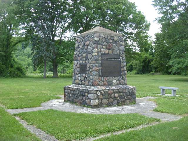
Photo: Doug Kerr, CC BY-SA 2.0 · Wikimedia Commons
Local history sources: en.wikipedia.org · archive.org · en.wikipedia.org · en.wikipedia.org · en.wikipedia.org · ohioriverscenicbyway.org · commons.wikimedia.org · archive.org · archive.org
Historic places
1 place in Lebanon Township, Meigs County on the National Register of Historic Places. Press a pin or a name for its whole record.
-
Buffington IslandSite · Pomeroy · listed 1970
- Address
- 20 mi. SE of Pomeroy on OH 124
- Where
- Pomeroy, Meigs County · ZIP 45770
- What it is
- Site
- Listed on the National Register
- 1970
- NRIS reference number
- 70000508
- Coordinates
- 39.00247, -81.77476
National Register file (NPS) ↗ Search Wikipedia ↗ Street map and directions ↗ On the Cracked Buckeye map
Source: National Park Service, National Register of Historic Places point file. The listing year is shown where NPS's certification date agrees with the listing's reference number. Listing recognizes significance; it does not restrict a private owner.
Water
Mostly private wells The water here
- Racine Village94% of residentsGroundwater wells (5 wells)
- Syracuse Village6% of residentsGroundwater wells (2 wells)
Hospitals, fire stations and more
Inside Lebanon Township, Meigs County's boundary: 2 poor-rated bridges, 2 shale and injection wells and 1 spill case. Press a pin or a name for its whole record and its source.
Bridges rated poor (2)
-
T135 Sellers Ridge over Groundhog CreekPoor · built 1950
- Condition
- Poor: a deck, superstructure, substructure or culvert rated 4 or below on the 0 to 9 scale
- What it is
- Bridge
- Built
- 1950
- Length
- 9 ft
- Owner
- County
- Vehicles a day
- 21
- Coordinates
- 38.98360, -81.80176
National Bridge Inventory (source) ↗ Street map and directions ↗
-
TR 29 Wells Run over Wells RunPoor · built 1935
- Condition
- Poor: a deck, superstructure, substructure or culvert rated 4 or below on the 0 to 9 scale
- What it is
- Bridge
- Built
- 1935
- Length
- 8 ft
- Owner
- County
- Vehicles a day
- 209
- Coordinates
- 39.03229, -81.79526
National Bridge Inventory (source) ↗ Street map and directions ↗
Source: FHWA National Bridge Inventory 2025. "Poor" means one major part rated 4 or below on the 0 to 9 scale; it calls for repair, not closing, unless the state posts or closes the bridge.
Shale and injection wells (2)
-
Harris C & W (Swiw #22) 1 InjectionInjection well (Class II)
- What it is
- Injection well (Class II)
- Operator
- Roscoe Mills Jr Trust
- County
- Meigs County
- API well number
- 34105236370000
- Coordinates
- 38.96982, -81.78598
ODNR oil and gas wells (source) ↗ Street map and directions ↗
-
Mckelvey (Swiw #23) 3 InjectionInjection well (Class II)
- What it is
- Injection well (Class II)
- Operator
- Deeprock Disposal Solutions Llc
- County
- Meigs County
- API well number
- 34105236510000
- Coordinates
- 38.96472, -81.78569
ODNR oil and gas wells (source) ↗ Street map and directions ↗
Source: ODNR Division of Oil and Gas Resources well inventory (September 2026): drilled Utica, Marcellus and horizontal wells and Class II injection wells not plugged. Older vertical wells are on the full map.
Spills reported since 2021 (1)
-
Fuel Diesel / Diesel Fuel (Vehicle On Or Off Road)2024-07-15 · Lebanon Twp
- Reported
- 2024-07-15
- What spilled
- Fuel Diesel / Diesel Fuel (Vehicle On Or Off Road)
- Largest amount reported
- 100 gallons
- Where
- Lebanon Twp, Meigs County
- Ohio EPA district office
- SEDO
- Ohio EPA case number
- 2407EPA0001195
Ohio EPA spill reports (source) ↗ Street map and directions ↗
Source: Ohio EPA emergency response spill reports, 2021 to September 2026, one point per case where Ohio EPA placed it. A report is what the caller or responder recorded; amounts are often blank or estimated.
Its ZIP codes
Each ZIP code that touches Lebanon Township, Meigs County, with the share of its residents who live here and the same headline figures as the ZIP page.
| ZIP | Share | Water | Radon | Home value | Schools | Flood |
|---|---|---|---|---|---|---|
| 45770 Lebanon Township and Portland | 100% | Mostly private wells | Too few radon tests | No homes in the parcel records | Southern Local · 3 stars overall | 9.0% of residents in the 1% floodplain |
| 45743 Chester Township and Long Bottom | 14% | Mostly private wells | Too few radon tests | No homes in the parcel records | Eastern Local · 3 stars overall | 9.8% of residents in the 1% floodplain |
| 45771 Sutton Township and Racine | 4% | Mostly private wells | Too few radon tests | Parcel list only | Southern Local · 3 stars overall | 11% of residents in the 1% floodplain |
Local government
Who holds office in Lebanon Township, Meigs County, how its elections and ballot issues came out, and the state auditor's record.
Money issues on the ballot since 2019: 3 of 3 passed; of those asking for new or higher taxes, 1 of 1.
Ballot issues
| Date | Issue | For | Against | Result |
|---|---|---|---|---|
| 2021-11-02 | Issue: Lebanon Twp. Roads Levy Renewal - 1.5mills/5yrs (1.5 mills, renewal) | 62 | 25 | Passed (71.26% for) |
| 2021-11-02 | Issue: Lebanon Twp. Cemetery Levy Replacement - 1mill/5yrs (1.0 mills, replacement) | 63 | 23 | Passed (73.26% for) |
| 2019-11-05 | Issue: Lebanon TWP Add 1 Mill Fire Protection (1.0 mills) | 88 | 75 | Passed (53.99% for) |
Elections for office
| Date | Office | Candidates and votes |
|---|---|---|
| 2021-11-02 | Township Trustee | Gary Cooper 67, 54.47%; Donald R. Dailey 56, 45.53% |
| 2019-11-05 | Township Trustee | Matthew S. Evans 64, 38.32%; Tyler J. Johnson 49, 29.34%; Dale C. Teaford, IV 54, 32.34% |
| 2019-11-05 | Township Fiscal Officer | Brenda S. Johnson 131, 100.0% |
Winners in bold. Results from the county board of elections' official canvass unless marked.
Auditor of State record
- No fiscal caution, watch or emergency on the Auditor of State's lists.
- Agreed Upon Procedures, 2022 to 2023, released 2024-08-27
The county
Meigs County: 12 ZIP codes, 16 cities, villages and townships, 20,189 people.
Nearby places
Quick answers
What county is Lebanon Township, Ohio in?
Lebanon Township, Meigs County is a township in Meigs County, Ohio, with 897 residents.
When was Lebanon Township, Ohio founded?
Lebanon Township, Meigs County was incorporated 1813 (township organized). Source
What ZIP code is Lebanon Township, Ohio?
Lebanon Township, Meigs County is served by ZIP codes 45770, 45743 and 45771; 45770 holds the largest share of its residents.
Where does Lebanon Township, Ohio get its water?
The main water source for Lebanon Township, Meigs County (Racine Village): Mostly private wells.
Cite this page
Cite this page as:
Cracked Buckeye, "Lebanon Township, Meigs County", https://crackedbuckeye.com/place/lebanon-township-meigs-county/, built 2026-10-31, accessed [date].
How to cite · Report a correction · Built 2026-10-31
