Mingo Junction
Village · Jefferson County · 3,146 residents · 2% municipal income tax
Local events in Mingo Junction
Mingo Junction itself has 2 events posted in the next 90 days; the others here are within 20 miles. All local events in Mingo Junction
Checked October 20; the events page is refreshed daily.
How Mingo Junction began
Mingo Junction takes its name from Mingo Town (also called Mingo Bottom), a documented 18th-century settlement of Seneca-Cayuga (Mingo) people on this stretch of the Ohio River, three miles below Steubenville, where George Washington camped overnight on October 22, 1770 and which was at times home to the Mingo leader Logan. Despite that long history as a landing, camp and Civil War staging ground, no village existed on the site until the fall of 1869, when an iron works was built there and gave the place its start as an industrial town; by 1900 the community's single dominant employer was a steel mill owned by Carnegie Steel Company. The village's population peaked at 5,030 in 1930 and had fallen to 3,347 by the 2020 census, a decline that has strained the customer base supporting its water system even as the mill site continues to anchor its economy and its municipal well field.
Settled documented occupied by 1770 (Mingo Town), platted fall 1869 (iron works and village), incorporated date not found in sources reviewed, by unnamed iron works investors, 1869.
Where the name comes from
Named for Mingo Town (Mingo Bottom), the Seneca-Cayuga (Mingo) settlement documented on this site through the 18th century; 'Junction' was added because the site became a railroad junction in 1853, well before the village itself existed.
Before the town
Mingo Town, also called Mingo Bottom, was a documented Seneca-Cayuga (Mingo) settlement on the Ohio River at the site of present Mingo Junction, occupied at least through the 1770s and into the early 1780s. George Washington camped there overnight on October 22, 1770 during his Ohio Valley expedition and recorded in his diary that the settlement then held about twenty cabins and seventy Haudenosaunee residents. The site was at times home to Logan (Tah-gah-jute), the Cayuga-born Mingo leader whose family was murdered at Yellow Creek in 1774, an event that triggered Lord Dunmore's War; Mingo Town later served, in 1782, as the staging and departure point for Colonel William Crawford's ill-fated expedition against Native towns on the Sandusky River, on which Crawford himself was captured and killed. The 1910 county history adds that 'the last recorded Indian fight' in this stretch of the county took place on the Adams farm about a mile west of Mingo, though it does not give a precise date. No village or industrial development occupied the site between these events and the 1869 founding of the iron works that became Mingo Junction -- a gap of roughly a century during which the place served only as a landing, a camp and, during the Civil War, a military staging ground.
Nations recorded here: Mingo (Seneca-Cayuga).
- Mingo Town (Mingo Bottom) (village) — Ohio River, site of present Mingo Junction, documented occupied 1770s, staging point through 1782 (en.wikipedia.org)
Timeline
- — George Washington camps overnight at Mingo Town on October 22 during his Ohio Valley expedition, recording about twenty cabins and seventy Haudenosaunee residents.
- — Mingo leader Logan, associated with Mingo Town, loses his family in the Yellow Creek killings upriver, an event that triggers Lord Dunmore's War.
- — Colonel William Crawford's expedition against Native towns on the Sandusky River departs from Mingo Town/Mingo Bottom; Crawford is captured and killed on the campaign.
- — The site becomes a railroad junction, giving rise to the later name Mingo Junction.
- — An iron works is built at the site in the fall, giving Mingo Junction its start as a village; before this there was, in the 1910 county history's words, 'not even the semblance of a village there.'
- — The village's only manufacturing plant is a steel mill owned by Carnegie Steel Company.
- — Central High School, a Tudor Revival building, is constructed; it and the adjacent Central Public School are later listed on the National Register of Historic Places on March 17, 1987.
- — Village population peaks at 5,030; it has fallen to 3,347 by the 2020 census.
Stories
A century of history before the town began
Mingo Junction is an unusual case in Jefferson County: the place had a long, well-documented history before it was ever a town. George Washington slept there in 1770 and wrote down what he saw -- about twenty cabins and seventy Haudenosaunee residents. The Mingo leader Logan, whose family's murder at Yellow Creek in 1774 helped trigger Lord Dunmore's War, was associated with the site. Colonel William Crawford's doomed 1782 expedition against the Sandusky towns launched from its riverbank, on a campaign that ended with Crawford's own capture and death. The site became a railroad junction in 1853 and served as a Civil War staging camp. And yet, as the 1910 county history puts it plainly, down to the autumn of 1869 there was 'not even the semblance of a village there' -- a hundred years of documented history on ground that stayed essentially unsettled until an iron works finally gave it a reason to become a town.
Photographs
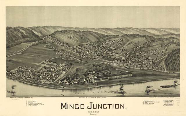
Photo: Library of Congress, Geography and Map Division, public domain · Wikimedia Commons
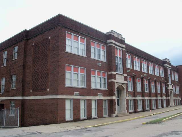
Photo: Roseohioresident, Wikimedia Commons, CC BY-SA 3.0 · Wikimedia Commons
Local history sources: en.wikipedia.org · ohiogenealogyexpress.com · ohiogenealogyexpress.com · ohiogenealogyexpress.com · commons.wikimedia.org · commons.wikimedia.org
Historic places
2 places in Mingo Junction on the National Register of Historic Places. Press a pin or a name for its whole record.
-
Central High SchoolBuilding · Mingo Junction · listed 1987
- Address
- 110 Steuben Ave.
- Where
- Mingo Junction, Jefferson County · ZIP 43938
- What it is
- Building
- Listed on the National Register
- 1987
- NRIS reference number
- 87000471
- Coordinates
- 40.31973, -80.60868
National Register file (NPS) ↗ Search Wikipedia ↗ Street map and directions ↗ On the Cracked Buckeye map
-
Central Public SchoolBuilding · Mingo Junction · listed 1987
- Address
- 109 Saint Clair Ave.
- Where
- Mingo Junction, Jefferson County · ZIP 43938
- What it is
- Building
- Listed on the National Register
- 1987
- NRIS reference number
- 87000472
- Coordinates
- 40.31973, -80.60809
National Register file (NPS) ↗ Search Wikipedia ↗ Street map and directions ↗ On the Cracked Buckeye map
Source: National Park Service, National Register of Historic Places point file. The listing year is shown where NPS's certification date agrees with the listing's reference number. Listing recognizes significance; it does not restrict a private owner.
Water
Groundwater wells (2 wells) The water here
- Mingo Junction86% of residentsGroundwater wells (2 wells)
- Steubenville, City Of10% of residentsOhio River
- Jefferson Co. W&s District- J3% of residentsGroundwater wells (2 wells)
- Brilliant Water and Sewer1% of residentsGroundwater wells (3 wells)
Hospitals, fire stations and more
Inside Mingo Junction's boundary: 1 fire or EMS station, 3 public schools, 1 poor-rated bridge, 1 police station, 3 Toxics Release Inventory facilities and 21 spill cases. Press a pin or a name for its whole record and its source.
Fire and EMS stations (1)
-
Mingo Junction Fire DepartmentMingo Junction
- Address
- 501 Commercial Street, Mingo Junction, OH 43938
- Coordinates
- 40.32196, -80.60617
USGS National Map structures (source) ↗ Street map and directions ↗
Source: USGS National Map structures (most Ohio records last updated 2019 to 2022), checked against the Columbus and Cleveland station lists. The department that answers a call is set by jurisdiction and mutual aid, not by distance.
Public schools (3)
-
Hills Elementary School4 of 5 stars · Mingo Junction
- Address
- 2281 Wilson Ave, Mingo Junction, OH 43938
- School district
- Indian Creek Local School District
- Kind (NCES)
- Regular School
- Students, 2023-24
- 371
- Teachers (full-time equivalent)
- 20.5
- Report card, 2025-26
- 4 of 5 stars
- Performance index
- 90.6%
- Ohio building IRN
- 016337
- NCES school ID
- 390478002999
NCES school record ↗ Ohio School Report Card ↗ Street map and directions ↗
-
Indian Creek Middle School Grades 5 & 62 of 5 stars · Mingo Junction
- Address
- 2379 Wilson Ave, Mingo Junction, OH 43938
- School district
- Indian Creek Local School District
- Kind (NCES)
- Regular School
- Students, 2023-24
- 258
- Teachers (full-time equivalent)
- 15.02
- Report card, 2025-26
- 2 of 5 stars
- Performance index
- 68.4%
- Ohio building IRN
- 014089
- NCES school ID
- 390478005768
NCES school record ↗ Ohio School Report Card ↗ Street map and directions ↗
-
Indian Creek Middle School Grades 7 & 82.5 of 5 stars · Mingo Junction
- Address
- 2379 Wilson Ave., Mingo Junction, OH 43938
- School district
- Indian Creek Local School District
- Kind (NCES)
- Regular School
- Students, 2023-24
- 259
- Teachers (full-time equivalent)
- 19.76
- Report card, 2025-26
- 2.5 of 5 stars
- Performance index
- 65.7%
- Ohio building IRN
- 025098
- NCES school ID
- 390478003000
NCES school record ↗ Ohio School Report Card ↗ Street map and directions ↗
Source: NCES EDGE public school locations 2024-25 and Common Core of Data 2023-24 (type, students, teachers); Ohio School Report Cards 2025-26 (Department of Education and Workforce), matched by name within the district.
Bridges rated poor (1)
-
SR 7 N.bound Only over Side Hill Structure Nb7Poor · built 1961
- Condition
- Poor: a deck, superstructure, substructure or culvert rated 4 or below on the 0 to 9 scale
- What it is
- Bridge
- Built
- 1961
- Length
- 72 ft
- Owner
- State
- Vehicles a day
- 9,392
- Coordinates
- 40.32729, -80.60558
National Bridge Inventory (source) ↗ Street map and directions ↗
Source: FHWA National Bridge Inventory 2025. "Poor" means one major part rated 4 or below on the 0 to 9 scale; it calls for repair, not closing, unless the state posts or closes the bridge.
Police stations (1)
-
Mingo Junction Police DepartmentMingo Junction
- Address
- 501 Commercial Street, Mingo Junction, OH 43938
- Coordinates
- 40.32208, -80.60619
USGS National Map structures (source) ↗ Street map and directions ↗
Source: USGS National Map structures, police stations, corrected and completed by hand (September 2026). The department that answers a call is set by jurisdiction, not by distance.
Facilities reporting toxic releases (3)
-
Jsw Steel Usa Ohio, Inc.Toxics Release Inventory · Mingo Junction
- Address
- 1500 Commercial Ave, Mingo Junction, OH 43938
- County
- Jefferson County County
- Status
- Reports to the Toxics Release Inventory (***unchanged***)
- EPA program ID
- 4393WJSWST15CMM
- EPA registry ID
- 110070209455
EPA facility record ↗ EPA Facility Registry Service (source) ↗ Street map and directions ↗
-
Tube City ImsToxics Release Inventory · Mingo Junction
- Address
- 200 Commercial St, Mingo Junction, OH 43938
- County
- Jefferson County
- Status
- Reports to the Toxics Release Inventory (active)
- EPA program ID
- 43938MSDVTCMMER
- EPA registry ID
- 110013855471
EPA facility record ↗ EPA Facility Registry Service (source) ↗ Street map and directions ↗
-
Wheeling Pittsburgh Steel Plant - Mingo Junction FacilityToxics Release Inventory · Mingo Junction
- Address
- 540 Commercial Street, Mingo Junction, OH 43938
- County
- Jefferson County
- Status
- Reports to the Toxics Release Inventory (open)
- EPA program ID
- 43952WHLNGMCLIS
- EPA registry ID
- 110000591592
EPA facility record ↗ EPA Facility Registry Service (source) ↗ Street map and directions ↗
Source: EPA Facility Registry Service, Toxics Release Inventory reporters. Reporting a release is required of large users of listed chemicals; it is not by itself a violation.
Spills reported since 2021 (21)
-
Fuel Diesel / Diesel Fuel (Vehicle On Or Off Road)2025-10-16 · Mingo Junction
- Reported
- 2025-10-16
- What spilled
- Fuel Diesel / Diesel Fuel (Vehicle On Or Off Road); Oil Hydraulic Fluid(S)
- Largest amount reported
- 58 gallons
- Where
- Mingo Junction, Jefferson County
- Ohio EPA district office
- SEDO
- Ohio EPA case number
- 2510EPA0001719
Ohio EPA spill reports (source) ↗ Street map and directions ↗
-
Oil Hydraulic Fluid(S)2025-05-09 · Mingo Junction
- Reported
- 2025-05-09
- What spilled
- Oil Hydraulic Fluid(S)
- Largest amount reported
- 100 gallons
- Where
- Mingo Junction, Jefferson County
- Ohio EPA district office
- SEDO
- Ohio EPA case number
- 2505EPA0000733
Ohio EPA spill reports (source) ↗ Street map and directions ↗
-
Paint Waste(S)2024-11-21 · Mingo Junction
- Reported
- 2024-11-21
- What spilled
- Paint Waste(S)
- Largest amount reported
- 150 gallons
- Where
- Mingo Junction, Jefferson County
- Ohio EPA district office
- SEDO
- Ohio EPA case number
- 2411EPA0001915
Ohio EPA spill reports (source) ↗ Street map and directions ↗
-
Sheen Rainbow / Hydrocarbon Reached water2024-08-02 · Mingo Junction
- Reported
- 2024-08-02
- What spilled
- Sheen Rainbow / Hydrocarbon
- Reached a waterway
- 41 - Ohio River
- Where
- Mingo Junction, Jefferson County
- Ohio EPA district office
- SEDO
- Ohio EPA case number
- 2408EPA0001326
Ohio EPA spill reports (source) ↗ Street map and directions ↗
-
Oil Hydraulic Fluid(S)2024-05-13 · Mingo Junction
- Reported
- 2024-05-13
- What spilled
- Oil Hydraulic Fluid(S)
- Largest amount reported
- 40 gallons
- Where
- Mingo Junction, Jefferson County
- Ohio EPA district office
- SEDO
- Ohio EPA case number
- 2405EPA0000792
Ohio EPA spill reports (source) ↗ Street map and directions ↗
-
Oil Motor / Lube Oil / Vehicle2024-04-18 · Mingo Junction
- Reported
- 2024-04-18
- What spilled
- Oil Motor / Lube Oil / Vehicle
- Largest amount reported
- 115 gallons
- Where
- Mingo Junction, Jefferson County
- Ohio EPA district office
- SEDO
- Ohio EPA case number
- 2404EPA0000651
Ohio EPA spill reports (source) ↗ Street map and directions ↗
-
Fuel Ethanol / E85 / Ethyl / Gasohol (Denatured)2024-02-26 · Mingo Junction
- Reported
- 2024-02-26
- What spilled
- Fuel Ethanol / E85 / Ethyl / Gasohol (Denatured)
- Largest amount reported
- 1 gallons
- Where
- Mingo Junction, Jefferson County
- Ohio EPA district office
- SEDO
- Ohio EPA case number
- 2402EPA0000297
Ohio EPA spill reports (source) ↗ Street map and directions ↗
-
Fuel Diesel / Diesel Fuel (Vehicle On Or Off Road)2024-01-19 · Mingo Junction
- Reported
- 2024-01-19
- What spilled
- Fuel Diesel / Diesel Fuel (Vehicle On Or Off Road)
- Largest amount reported
- 40 gallons
- Where
- Mingo Junction, Jefferson County
- Ohio EPA district office
- SEDO
- Ohio EPA case number
- 2401EPA0000097
Ohio EPA spill reports (source) ↗ Street map and directions ↗
-
Oil Hydraulic Fluid(S)2023-06-12 · Mingo Junction
- Reported
- 2023-06-12
- What spilled
- Oil Hydraulic Fluid(S)
- Largest amount reported
- 25 gallons
- Where
- Mingo Junction, Jefferson County
- Ohio EPA district office
- SEDO
- Ohio EPA case number
- 2306EPA0000972
Ohio EPA spill reports (source) ↗ Street map and directions ↗
-
Oil Transformer Non Pcb2023-05-16 · Mingo Junction
- Reported
- 2023-05-16
- What spilled
- Oil Transformer Non Pcb
- Largest amount reported
- 40 gallons
- Where
- Mingo Junction, Jefferson County
- Ohio EPA district office
- SEDO
- Ohio EPA case number
- 2305EPA0000795
Ohio EPA spill reports (source) ↗ Street map and directions ↗
-
Oil Hydraulic Fluid(S)2023-02-11 · Mingo Junction
- Reported
- 2023-02-11
- What spilled
- Oil Hydraulic Fluid(S)
- Largest amount reported
- 55 gallons
- Where
- Mingo Junction, Jefferson County
- Ohio EPA district office
- SEDO
- Ohio EPA case number
- 2302EPA0000214
Ohio EPA spill reports (source) ↗ Street map and directions ↗
-
Oil Hydraulic Fluid(S)2023-01-12 · Mingo Junction
- Reported
- 2023-01-12
- What spilled
- Oil Hydraulic Fluid(S)
- Largest amount reported
- 60 gallons
- Where
- Mingo Junction, Jefferson County
- Ohio EPA district office
- SEDO
- Ohio EPA case number
- 2301EPA0000060
Ohio EPA spill reports (source) ↗ Street map and directions ↗
-
Fuel Diesel / Diesel Fuel (Vehicle On Or Off Road)2022-12-21 · Mingo Junction
- Reported
- 2022-12-21
- What spilled
- Fuel Diesel / Diesel Fuel (Vehicle On Or Off Road)
- Largest amount reported
- 10 gallons
- Where
- Mingo Junction, Jefferson County
- Ohio EPA district office
- SEDO
- Ohio EPA case number
- 2212EPA0001891
Ohio EPA spill reports (source) ↗ Street map and directions ↗
-
Sewage Human2022-12-05 · Mingo Junction
- Reported
- 2022-12-05
- What spilled
- Sewage Human
- Where
- Mingo Junction, Jefferson County
- Ohio EPA district office
- SEDO
- Ohio EPA case number
- 2212EPA0001800
Ohio EPA spill reports (source) ↗ Street map and directions ↗
-
Oil Hydraulic Fluid(S)2022-10-20 · Mingo Junction
- Reported
- 2022-10-20
- What spilled
- Oil Hydraulic Fluid(S)
- Largest amount reported
- 50 gallons
- Where
- Mingo Junction, Jefferson County
- Ohio EPA district office
- SEDO
- Ohio EPA case number
- 2210EPA0001576
Ohio EPA spill reports (source) ↗ Street map and directions ↗
-
Fuel Diesel / Diesel Fuel (Vehicle On Or Off Road)2021-10-30 · Mingo Junction
- Reported
- 2021-10-30
- What spilled
- Fuel Diesel / Diesel Fuel (Vehicle On Or Off Road)
- Where
- Mingo Junction, Jefferson County
- Ohio EPA district office
- SEDO
- Ohio EPA case number
- 2110EPA0001685
Ohio EPA spill reports (source) ↗ Street map and directions ↗
-
Oil Hydraulic Fluid(S)2021-10-21 · Mingo Junction
- Reported
- 2021-10-21
- What spilled
- Oil Hydraulic Fluid(S)
- Largest amount reported
- 30 gallons
- Where
- Mingo Junction, Jefferson County
- Ohio EPA district office
- SEDO
- Ohio EPA case number
- 2110EPA0001645
Ohio EPA spill reports (source) ↗ Street map and directions ↗
-
Oil Hydraulic Fluid(S)2021-10-06 · Mingo Junction
- Reported
- 2021-10-06
- What spilled
- Oil Hydraulic Fluid(S)
- Largest amount reported
- 125 gallons
- Where
- Mingo Junction, Jefferson County
- Ohio EPA district office
- SEDO
- Ohio EPA case number
- 2110EPA0001581
Ohio EPA spill reports (source) ↗ Street map and directions ↗
-
Oil Hydraulic Fluid(S)2021-05-16 · Mingo Junction
- Reported
- 2021-05-16
- What spilled
- Oil Hydraulic Fluid(S)
- Largest amount reported
- 400 gallons
- Where
- Mingo Junction, Jefferson County
- Ohio EPA district office
- SEDO
- Ohio EPA case number
- 2105EPA0000685
Ohio EPA spill reports (source) ↗ Street map and directions ↗
-
Oil Motor / Lube Oil / Vehicle2021-02-26 · Mingo Junction
- Reported
- 2021-02-26
- What spilled
- Oil Motor / Lube Oil / Vehicle
- Largest amount reported
- 100 gallons
- Where
- Mingo Junction, Jefferson County
- Ohio EPA district office
- SEDO
- Ohio EPA case number
- 2102EPA0000249
Ohio EPA spill reports (source) ↗ Street map and directions ↗
-
Battery / Batteries Wet Cell2026-08-24 · Mingo Junction
- Reported
- 2026-08-24
- What spilled
- Battery / Batteries Wet Cell
- Largest amount reported
- 4 gallons
- Where
- Mingo Junction, Jefferson County
- Ohio EPA district office
- SEDO
- Ohio EPA case number
- 2608EPA0001589
Ohio EPA spill reports (source) ↗ Street map and directions ↗
Source: Ohio EPA emergency response spill reports, 2021 to September 2026, one point per case where Ohio EPA placed it. A report is what the caller or responder recorded; amounts are often blank or estimated.
Its ZIP codes
Each ZIP code that touches Mingo Junction, with the share of its residents who live here and the same headline figures as the ZIP page.
| ZIP | Share | Water | Radon | Home value | Schools | Flood |
|---|---|---|---|---|---|---|
| 43938 Mingo Junction | 61% | Groundwater wells (2 wells) | 3.6 pCi/L average radon | Median year built 1954 | Indian Creek Local · 3.5 stars overall | 1.8% of residents in the 1% floodplain |
The county
Jefferson County: 21 ZIP codes, 33 cities, villages and townships, 67,859 people.
Nearby places
Rain and snow
How much has actually fallen on Mingo Junction, day by day, from 1878 to now. Daily totals, not averages.
- rain, last 30 days
- 1.66 in
- 2026-09-30 to 2026-10-29
- rain so far in 2026
- 40.5 in
- 3.9 in above normal for the date
- snow so far in 2026
- 23.7 in
- a normal year brings 23.5 in
- a normal year
- 43.2 in
- average of 30 years, 1991-2020
| Month | Rain (in) | Snow (in) | Days counted |
|---|---|---|---|
| October 2026 | 1.66 | — | 29 |
| September 2026 | 4.43 | — | 30 |
| August 2026 | 8.85 | — | 31 |
| July 2026 | 3.75 | — | 31 |
| June 2026 | 3.62 | — | 30 |
| May 2026 | 5.44 | — | 31 |
| April 2026 | 4.12 | 0.0 | 30 |
| March 2026 | 5.55 | 2.9 | 31 |
| February 2026 | 0.73 | 2.7 | 28 |
| January 2026 | 2.38 | 18.1 | 31 |
| December 2025 | 1.80 | 13.1 | 31 |
| November 2025 | 2.00 | 0.0 | 30 |
| Wettest year | 2018 — 67.0 in |
|---|---|
| Driest year | 1930 — 25.5 in |
| Snowiest year | 1910 — 77.1 in |
| Wettest day on record | 30 September 1911 — 5.24 in |
| Heaviest snowfall in a day | 25 November 1950 — 18.23 in |
| Deepest snow on the ground | 18 February 2010 — 26.61 in |
Estimated, not measured. No rain gauge has ever stood inside Mingo Junction, so every figure here is worked out from the gauges around it - the nearest ones weighted most. Treat them as close estimates rather than readings.
51,214 days of records, 1878-02-01 to 2026-10-29. Source: NOAA NCEI GHCN-Daily, 3,240 gauges in and around Ohio. A day is "gauged" when a gauge standing inside the boundary reported it, and the value is the mean of those gauges. Otherwise it is interpolated by inverse distance from every gauge reporting within 50 miles. Nothing is carried forward, back-filled or smoothed. Against NOAA nClimDiv county monthly precipitation over 136,848 complete county-months (checked 2026-10-31): correlation 0.9515, median absolute difference 0.217 in a month. Built 2026-10-31 from the Cracked Buckeye precipitation archive. Snow is the softer number — snowfall is measured by hand with a ruler, no agency publishes a gridded county snowfall series, and blowing snow defeats every observer.
Environmental permits and filings
What Ohio EPA has on file for Mingo Junction: permits, inspections, violations, cleanups and the state loans behind sewer and water work. Every line links to the agency's own document.
- facilities and sites on file
- 26
- those placed on the map inside Mingo Junction
Data centers, power and big tech here. Ohio EPA files that name a data-center company, a power plant or substation, or a large technology firm:
- MINGO JUNCTION ENERGY CENTER LLC (air pollution, latest Dec 7, 2018)
| Program | Facilities and sites |
|---|---|
| Air pollution | 9 |
| State sewer loans | 6 |
| Hazardous waste | 3 |
| Wastewater and stormwater discharge | 3 |
| Voluntary cleanup | 2 |
| Air Nuisance | 1 |
| Public drinking water | 1 |
| Source-water protection | 1 |
| Date | Facility or site | What |
|---|---|---|
| MINGO JUNCTION PWS | Public drinking water compliance letter | |
| FE X PROCESSING LLC | Air pollution permit | |
| FE X PROCESSING LLC (PORTABLE 2) | Air pollution report | |
| FE X PROCESSING LLC | Air pollution report | |
| MINGO JUNCTION STP | State sewer loans | |
| MINGO JUNCTION PWS | Public drinking water compliance letter | |
| JSW STEEL USA OHIO INC | Wastewater and stormwater discharge report | |
| JSW STEEL USA OHIO INC | Wastewater and stormwater discharge report | |
| MINGO JUNCTION PWS | Public drinking water notice of violation | |
| MINGO JUNCTION PWS | Source-water protection report | |
| JSW STEEL USA OHIO INC | Wastewater and stormwater discharge report | |
| MINGO JUNCTION PWS | Public drinking water report | |
| MINGO JUNCTION STP | State sewer loans | |
| FE X PROCESSING LLC | Air pollution report | |
| FE X PROCESSING LLC (PORTABLE 2) | Air pollution report | |
| MINGO JUNCTION PWS | Public drinking water notice of violation | |
| MINGO JUNCTION PWS | Public drinking water plan | |
| MINGO JUNCTION PWS | Public drinking water inspection | |
| INDIAN CREEK COMMUNITY INNOVATION CENTER | Wastewater and stormwater discharge permit | |
| JSW STEEL USA OHIO INC | Air pollution director's orders | |
| JSW STEEL USA OHIO INC | Air Nuisance director's orders | |
| MINGO JUNCTION PWS | Public drinking water compliance letter | |
| JSW STEEL USA OHIO INC | Wastewater and stormwater discharge director's orders | |
| MINGO JUNCTION PWS | Public drinking water compliance letter | |
| JSW STEEL USA OHIO INC | Wastewater and stormwater discharge permit |
Source: Ohio EPA eDocument portal (edocpub.epa.ohio.gov), indexed 2026-10-14. Facilities are placed on the map from Ohio EPA's own map layers, EPA's Facility Registry, coordinates written in the filings, or a geocoded street address. A permit filed under a private person's name (most are household septic systems) is counted but never named, placed or linked; licenses for individual workers and open-burning notices are left out entirely.
Quick answers
What county is Mingo Junction, Ohio in?
Mingo Junction is a village in Jefferson County, Ohio, with 3,146 residents.
When was Mingo Junction, Ohio founded?
Mingo Junction was settled documented occupied by 1770 (Mingo Town); laid out fall 1869 (iron works and village); incorporated date not found in sources reviewed. Founders on record: unnamed iron works investors, 1869. Source
How did Mingo Junction, Ohio get its name?
Named for Mingo Town (Mingo Bottom), the Seneca-Cayuga (Mingo) settlement documented on this site through the 18th century; 'Junction' was added because the site became a railroad junction in 1853, well before the village itself existed. Source
What ZIP code is Mingo Junction, Ohio?
Most of Mingo Junction is in ZIP code 43938.
Where does Mingo Junction, Ohio get its water?
The main water source for Mingo Junction (Mingo Junction): Groundwater wells (2 wells).
Cite this page
Cite this page as:
Cracked Buckeye, "Mingo Junction, Jefferson County", https://crackedbuckeye.com/place/mingo-junction/, built 2026-10-31, accessed [date].
How to cite · Report a correction · Built 2026-10-31
