Water system
Mingo Junction
EPA ID OH4101612 · Jefferson County · 3,350 people served · owned by a local government
Mingo Junction treats its own water from Groundwater wells (2 wells).
The system's record
- Active wells
- 2
- Serves
- 3,350 people · Jefferson County
- EPA ID
- OH4101612
About this area's water
Did you know
- George Washington recorded visiting Mingo Town here in 1770, describing about 20 cabins and 70 inhabitants of the Iroquois Confederation; the same spot was the launch point for the ill-fated Crawford expedition in 1782.
- The village's North production well is drilled inside the JSW Steel mill complex, and the South well sits just west of the marina, so Mingo Junction's drinking water comes out of the ground under an active steel plant…
- Until 2003 the village drew on a Ranney collector well that Ohio EPA classified as a surface-water intake; it was deactivated on March 5, 2003, and the system has been all drilled wells since.
- Population has tracked a single mill: 371 in 1880, 5,030 at the 1930 peak, 3,347 in 2020.
- Mingo Junction keeps a decade of water quality reports, 2016 through 2025, in a public Google Drive folder linked off its water department page, which is more than many villages its size publish.
History6
- 1869Mingo Junction was founded when an iron works was started on the site of the old Mingo Town settlement on the Ohio River.
- 1900The village's only manufacturing plant was a steel mill owned by Carnegie Steel Company; the mill site is still where the village's North production well sits today.
- 1930Population peaked at 5,030 and has fallen since to 3,347 in the 2020 census, shrinking the customer base that pays for the water plant.
- 2003The village's Ranney collector well, which Ohio EPA classified as a surface-water intake, was deactivated on March 5, 2003, leaving the system on drilled wells only.
- 2016-2017Health-based MCL violations for total trihalomethanes in three consecutive quarterly compliance periods (Q4 2016, Q1 2017, Q2 2017), with running annual averages of 0.082, 0.082 and 0.081 mg/L…
- 2024In December 2024 the village failed to make its 2023 Consumer Confidence Report adequately available and the report was short on required data; the village says availability was corrected and…
Treatment & pressure
How it is treated
A conventional lime-softening surface-style plant run on well water. EPA's SDWIS treatment record for the Mingo Junction WTP lists coagulation, flocculation, rapid sand filtration, lime-soda ash softening, pH adjustment, a polyphosphate corrosion inhibitor, post gaseous chlorination and…
Source: data.epa.govdrive.google.comdata.epa.gov
Water pressure
Not published. No CCR, pressure-zone map or engineering report giving a service pressure or psi range was located; the CCRs do not discuss distribution pressure.
What it costs
Not published online. The village water department page gives payment methods, drop-box locations and a bill-pay portal (mingojct.ohiobillpay.com) but no rate schedule, and no…
Source: mingojct.us
Water quality & impurities10
| Contaminant | Level | Limit | Year |
|---|---|---|---|
| Total Trihalomethanes (TTHM) Range 27.3-57.1 ppb. No violation in 2024, but the system exceeded the 80 ppb MCL in 2016-2017, so this remains its… | 57.1 ppb | 80 | 2024 |
| Haloacetic Acids (HAA5) Range 4.4-5.4 ppb. | 5.4 ppb | 60 | 2024 |
| Total Chlorine Range 0.63-1.06 ppm. | 0.95 ppm | MRDL=4 | 2024 |
| Fluoride Range 0.94-1.05 ppm; water additive plus natural deposits. | 0.99 ppm | 4 | 2024 |
| Barium The CCR prints the level in ppb but the MCL as '2', which is the ppm figure; the federal MCL is 2 ppm, i.e. 2,000 ppb.… | 32.3 ppb | 2000 | 2024 |
| Chromium The CCR lists the typical source as discharge from steel and pulp mills, notable given the North well sits inside the… | 1.4 ppb | 100 | 2024 |
| Nitrate Single detection, well below the limit. | 0.36 ppm | 10 | 2024 |
| Dichloroethane A volatile organic detection at under 1 percent of the MCL; consistent with Ohio EPA's high-susceptibility rating for… | 0.06 ppb | 7 | 2024 |
| Lead (90th percentile) 0 of 20 samples exceeded the action level. | 0 ppb | AL=15 | 2024 |
| Copper (90th percentile) 0 of 20 samples exceeded the action level. | 0.021 ppm | AL=1.3 | 2024 |
Source: drive.google.comdata.epa.gov
EPA compliance record
Lead at the tap: 90th-percentile result 1.4 ppb in 2025 (action level 15 ppb).
EPA health-based violations since 2015:
- 2017Total trihalomethanes (TTHM) · exceeded a maximum contaminant level · measured 0.082 MG/L (limit 0.08 MG/L) · returned to compliance
- 2016Total trihalomethanes (TTHM) · exceeded a maximum contaminant level · measured 0.082 MG/L (limit 0.08 MG/L) · returned to compliance
EPA's count of 3 includes 1 repeat quarterly violation of the problems listed.
2 violations of any kind logged since 2020, 2 of them paperwork (monitoring, reporting, public notice or consumer report).
Supply stress
The 2025 CCR states that the Village of Mingo Junction is considered a 'high susceptibility PWS' and that, per an earlier Ohio EPA source-water study, the aquifer supplying the village has a high susceptibility to contamination. The two production wells are only about seventy feet deep in the Ohio River valley, and the North well is…
Source: drive.google.comdata.epa.gov
Sewers
Sanitary
Village-operated wastewater department at 501 Commercial Street, run under EPA permit #OPD00010*MD. The village has posted wet-weather sewage overflow warning signs at the Mingo Marina shelter house and on the Cross Creek bank near the old Mingo Stadium, and Ohio EPA-mandated signage at its biosolids farm site, which indicates both…
Storm
Not documented. The village publishes nothing on storm sewers or on whether the collection system is combined or separate.
Source: mingojct.us
Sourcesverified
Compiled from the utility's own reports and public records, then independently re-checked against primary sources.
Main supplier in 1 ZIP code
Serves
Main water supplier in 1 ZIP code
- 43938 · Mingo Junction63% of residents
Population-weighted resident shares; a ZIP code can have more than one system on record. Recomputed from each ZIP's own system list, not from the map's cached footprint.
Buys from · Sells to
Mingo Junction does not buy water from another system on record; it treats its own source water.
1 system on record buys water from Mingo Junction: Jefferson Co. W&s District- J.
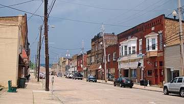
Photograph
On the map
Show this system's territory on the map — 1 ZIP code in all.
Sources
U.S. EPA SDWIS and Community Water System Service Area Boundaries (v3, 2026), Ohio EPA primacy data, 2020 census blocks: the system serving most residents, traced through purchases to the treating utility; Ohio EPA 2023 Sewer and Water Rate Survey (Ohio State, May 2025) for household bills; Ohio EPA DEFA loan awards since 2016 for the loans paragraph · EPA SDWIS · EPA service area boundaries · Ohio EPA drinking water · Ohio EPA rate survey
Notable facts: en.wikipedia.org, drive.google.com, data.epa.gov, mingojct.us
History: en.wikipedia.org, data.epa.gov, data.epa.gov, drive.google.com
Water quality: drive.google.com, data.epa.gov
Rates: mingojct.us
Sewers: mingojct.us
Treatment: data.epa.gov, drive.google.com, data.epa.gov
Supply stress: drive.google.com, data.epa.gov