Local events in Jackson Township, Allen County
Nothing is posted for Jackson Township itself yet; here is what is on within 10 miles. All local events in Jackson Township, Allen County
Know a calendar we should watch? Send the link
Checked October 20; the events page is refreshed daily.
How Jackson Township, Allen County began
Jackson Township, on the eastern line of Allen County, was set off when the county commissioners received a petition on June 6, 1831, and was finally organized as a congressional township in December 1834 after Auglaize, Perry and Bath townships claimed some of its sections. Jacob Hawk bought the first parcel of public land in 1827, and by about 1836 every section had an owner. The village of Lafayette (Section 28), on the Pennsylvania Railroad, is its market town, and water-lime quarries west of it supplied building stone. The township had 1,803 people in 1885 and 3,143 in 2020.
Settled 1827 (first land purchase, Jacob Hawk); active settlement from the early 1830s, incorporated petition June 6, 1831; organized December 1834, by William Watt, William Reese and Thomas Nash were the first trustees; John Jamieson first Justice of the Peace; Joseph Hall first clerk.
Where the name comes from
The 1885 county history does not say why the township is called Jackson, and Wikipedia notes only that it is one of thirty-seven Jackson Townships in Ohio.
Before the town
No Native American village, mound or trail specific to Jackson Township is recorded in the sources checked. The township's many small streams are tributaries of the Upper Ottawa River, called Hog Creek, whose lower course ran through the Shawnee Hog Creek Reservation in what is now Shawnee Township; the reservation was held from 1817 until the Shawnee ceded their Ohio lands at Wapakoneta in 1831, the year Jackson's petition was filed. The township lies in the northwestern Ohio land ceded in the 1817 Treaty of Fort Meigs.
Nations recorded here: Shawnee.
Timeline
- — Jacob Hawk buys the first parcel of public land in the township's survey township (Section 19).
- — Anthony Hall enters land in Section 17; entries multiply from 1832 (Joseph Marsh, John B. Walton, Jacob Puterbaugh, John Jameson).
- — A petition to establish Jackson Township is presented to the county commissioners, who set off its territory.
- — A schoolhouse is built on Section 24, with Thomas Hall as teacher (one account; another places the first school in 1838).
- — After Auglaize and Perry townships claimed their sections and Bath its eastern ones, Jackson is organized as a congressional township.
- — Six years after 1830, the 1885 history says, every section in the township has an occupying owner.
- — Methodist ministers begin to be appointed to the Lafayette society, which had met for years without organization; the first quarterly meeting follows in 1851.
- — The county commissioners authorize the incorporation of Lafayette village.
- — An Italianate brick farmhouse is built on what is now Napoleon Road, south of Lafayette.
- — The township has eleven school buildings, two built that year, and an enrollment of 444; stone quarries three miles west of Lafayette (Jacob Custer) and near the village (the Cloore quarries) produce water-lime rock.
- — Population is 1,803, including 333 at Lafayette, up about 200 in four years.
- — Census population is 3,143.
Stories
A township assembled from claims
Jackson Township did not simply appear on the map. On June 6, 1831, a petition set off all of Township 3 South, Range 8 East, the eastern half of Township 3 South, Range 7 East, and the northern tier of sections of Township 4 South, Range 8 East. Over the next three years neighboring jurisdictions took parts back: Auglaize and Perry townships claimed their sections in December 1833, and Bath its eastern sections a year later. Only in December 1834 was Jackson organized as a congressional township under its original name, with William Watt, William Reese and Thomas Nash as trustees, John Jamieson as justice and Joseph Hall as clerk. The 1885 county historian called the list of original land entries, running from Jacob Hawk's 1827 purchase to the 1840s, the basis of the township's history.
Stone from the Ottawa headwaters
Jackson Township is cut by many small streams, all tributaries of the Upper Ottawa or Hog Creek, and its soil runs from light sand and gravel to heavy clay. Under the farms lies a bed of water-lime limestone. In 1885 Jacob Custer worked quarries three miles west of Lafayette, taking a rock about eight inches thick from an excavation roughly twenty feet deep, and the Cloore quarries near the village produced an equally good but lighter stone. The township's farmers could ship by the Pennsylvania Railroad's main line through Lafayette, and it had grown by about 200 people in the four years to March 1885.
Photographs
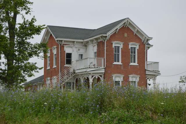
Photo: Nyttend, public domain · Wikimedia Commons
Local history sources: archive.org · en.wikipedia.org · en.wikipedia.org · commons.wikimedia.org
Water
Mostly private wells The water here
- Lima City79% of residentsAuglaize River and Ottawa River, stored in city upground reservoirs
- Ada Village11% of residentsGroundwater wells (3 wells)
- Sun Valley Family Campground8% of residentsGroundwater wells (2 wells)
- Bluffton Village2% of residentsBlanchard River (via intake reservoir)
- Hillcrest Estates Mobile Home Court0% of residentsGroundwater wells (1 wells)
- Green Meadow MHP-hancock Co0% of residentsGroundwater wells (1 wells)
Hospitals, fire stations and more
Inside Jackson Township, Allen County's boundary: 3 public schools, 2 poor-rated bridges, 1 Toxics Release Inventory facility and 4 spill cases. Press a pin or a name for its whole record and its source.
Public schools (3)
-
Allen East Elementary School2.5 of 5 stars · Harrod
- Address
- 9105 Harding Hwy, Harrod, OH 45850
- School district
- Allen East Local School District
- Kind (NCES)
- Regular School
- Students, 2023-24
- 467
- Teachers (full-time equivalent)
- 27
- Report card, 2025-26
- 2.5 of 5 stars
- Performance index
- 74%
- Ohio building IRN
- 000448
- NCES school ID
- 390457502332
NCES school record ↗ Ohio School Report Card ↗ Street map and directions ↗
-
Allen East High School4 of 5 stars · Harrod
- Address
- 9105 Harding Hwy, Harrod, OH 45850
- School district
- Allen East Local School District
- Kind (NCES)
- Regular School
- Students, 2023-24
- 258
- Teachers (full-time equivalent)
- 18
- Report card, 2025-26
- 4 of 5 stars
- Performance index
- 80.6%
- Four-year graduation rate
- 93.3%
- Ohio building IRN
- 000364
- NCES school ID
- 390457502331
NCES school record ↗ Ohio School Report Card ↗ Street map and directions ↗
-
Allen East Middle School3 of 5 stars · Harrod
- Address
- 9105 Harding Hwy, Harrod, OH 45850
- School district
- Allen East Local School District
- Kind (NCES)
- Regular School
- Students, 2023-24
- 333
- Teachers (full-time equivalent)
- 14
- Report card, 2025-26
- 3 of 5 stars
- Performance index
- 72.8%
- Ohio building IRN
- 015724
- NCES school ID
- 390457505882
NCES school record ↗ Ohio School Report Card ↗ Street map and directions ↗
Source: NCES EDGE public school locations 2024-25 and Common Core of Data 2023-24 (type, students, teachers); Ohio School Report Cards 2025-26 (Department of Education and Workforce), matched by name within the district.
Bridges rated poor (2)
-
Lafayette Rd. over Ltl Hog Cr Lafayette RdPoor · built 1978
- Condition
- Poor: a deck, superstructure, substructure or culvert rated 4 or below on the 0 to 9 scale
- What it is
- Culvert
- Built
- 1978
- Length
- 8 ft
- Owner
- County
- Vehicles a day
- 291
- Coordinates
- 40.76142, -83.89926
National Bridge Inventory (source) ↗ Street map and directions ↗
-
Phillips Rd. over Ottawa River Phillips RdPoor · built 1989
- Condition
- Poor: a deck, superstructure, substructure or culvert rated 4 or below on the 0 to 9 scale
- What it is
- Bridge
- Built
- 1989
- Length
- 46 ft
- Owner
- County
- Vehicles a day
- 716
- Coordinates
- 40.77560, -83.93729
National Bridge Inventory (source) ↗ Street map and directions ↗
Source: FHWA National Bridge Inventory 2025. "Poor" means one major part rated 4 or below on the 0 to 9 scale; it calls for repair, not closing, unless the state posts or closes the bridge.
Facilities reporting toxic releases (1)
-
Tanner Industries, Inc.Toxics Release Inventory · Lima
- Address
- 8070 Harding Highway, Lima, OH 45801
- County
- Allen County
- Status
- Reports to the Toxics Release Inventory (***unchanged***)
- EPA program ID
- 4580WTNNRN87HAR
- EPA registry ID
- 110064590982
EPA facility record ↗ EPA Facility Registry Service (source) ↗ Street map and directions ↗
Source: EPA Facility Registry Service, Toxics Release Inventory reporters. Reporting a release is required of large users of listed chemicals; it is not by itself a violation.
Spills reported since 2021 (4)
-
Oil Motor / Lube Oil / Vehicle2024-01-29 · Jackson Twp
- Reported
- 2024-01-29
- What spilled
- Oil Motor / Lube Oil / Vehicle
- Where
- Jackson Twp, Allen County
- Ohio EPA district office
- NWDO
- Ohio EPA case number
- 2401EPA0000151
Ohio EPA spill reports (source) ↗ Street map and directions ↗
-
Asphalt / Bitumen2023-09-09 · Jackson Twp
- Reported
- 2023-09-09
- What spilled
- Asphalt / Bitumen
- Where
- Jackson Twp, Allen County
- Ohio EPA district office
- NWDO
- Ohio EPA case number
- 2309EPA0001583
Ohio EPA spill reports (source) ↗ Street map and directions ↗
-
Orphan Drum(S) Reached water2026-07-20 · Jackson Twp
- Reported
- 2026-07-20
- What spilled
- Orphan Drum(S)
- Reached a waterway
- 99 - Unnamed
- Where
- Jackson Twp, Allen County
- Ohio EPA district office
- NWDO
- Ohio EPA case number
- 2607EPA0001319
Ohio EPA spill reports (source) ↗ Street map and directions ↗
-
Fuel Gasoline ( 25% Ethanol Not E85)2026-03-28 · Richland Twp
- Reported
- 2026-03-28
- What spilled
- Fuel Gasoline ( 25% Ethanol Not E85)
- Largest amount reported
- 50 gallons
- Where
- Richland Twp, Allen County
- Ohio EPA district office
- NWDO
- Ohio EPA case number
- 2603EPA0000509
Ohio EPA spill reports (source) ↗ Street map and directions ↗
Source: Ohio EPA emergency response spill reports, 2021 to September 2026, one point per case where Ohio EPA placed it. A report is what the caller or responder recorded; amounts are often blank or estimated.
Its ZIP codes
Each ZIP code that touches Jackson Township, Allen County, with the share of its residents who live here and the same headline figures as the ZIP page.
Local government
Who holds office in Jackson Township, Allen County, how its elections and ballot issues came out, and the state auditor's record.
Elections for office
| Date | Office | Candidates and votes |
|---|---|---|
| 2017-11-07 | Township Trustee | Randy Ackerman 506, 37.73%; James Shilling 383, 28.56%; Thad Russell Staley 452, 33.71% |
| 2015-11-03 | Township Trustee | Ted B. Smith 852, 100.0% |
Winners in bold. Results from the county board of elections' official canvass unless marked.
Auditor of State record
- No fiscal caution, watch or emergency on the Auditor of State's lists.
- Agreed Upon Procedures, 2024 to 2025, released 2026-09-15
- Agreed Upon Procedures, 2022 to 2023, released 2024-09-19
The county
Allen County: 13 ZIP codes, 26 cities, villages and townships, 110,066 people.
Nearby places
Quick answers
What county is Jackson Township, Ohio in?
Jackson Township, Allen County is a township in Allen County, Ohio, with 2,737 residents.
When was Jackson Township, Ohio founded?
Jackson Township, Allen County was settled 1827 (first land purchase, Jacob Hawk); active settlement from the early 1830s; incorporated petition June 6, 1831; organized December 1834. Founders on record: William Watt, William Reese and Thomas Nash were the first trustees; John Jamieson first Justice of the Peace; Joseph Hall first clerk. Source
How did Jackson Township, Ohio get its name?
The 1885 county history does not say why the township is called Jackson, and Wikipedia notes only that it is one of thirty-seven Jackson Townships in Ohio. Source
What ZIP code is Jackson Township, Ohio?
Jackson Township, Allen County is served by ZIP codes 45850, 45854, 45801 and 45810; 45850 holds the largest share of its residents.
Where does Jackson Township, Ohio get its water?
The main water source for Jackson Township, Allen County (Lima City): Mostly private wells.
Cite this page
Cite this page as:
Cracked Buckeye, "Jackson Township, Allen County", https://crackedbuckeye.com/place/jackson-township-allen-county/, built 2026-10-31, accessed [date].
How to cite · Report a correction · Built 2026-10-31
