Local events in Darby Township, Pickaway County
Nothing is posted for Darby Township itself yet; here is what is on within 20 miles. All local events in Darby Township, Pickaway County
Know a calendar we should watch? Send the link
Checked October 20; the events page is refreshed daily.
How Darby Township, Pickaway County began
Darby Township, in the northwest corner of Pickaway County, was first organized in 1803 as the second township of Franklin County -- one of the very first four townships laid out anywhere in that county -- and became part of Pickaway County when it was formed in 1810. Its earliest white settlers, the Poulson brothers from Virginia, arrived on Darby Creek about 1802, finding Wyandot hunters still camped nearby; the little hamlet of Palestine, laid out in 1829 on Deer Creek, was for decades the township's trading center before it faded. The township takes its name, and Darby Creek its own, from a Native chief remembered only as Darby. Today it is a rural township centered on the census-designated place of Derby, with the Franklin County line and Big Darby Creek, now a state and federally designated scenic river, forming much of its northern and eastern edge.
Settled c. 1800-1802 (the Poulson brothers -- Andrew, Cornelius, John, Elijah and William -- from Virginia), incorporated organized May 10, 1803, as the second township of Franklin County (boundaries then differed from today's); became a township of Pickaway County when the county was formed in 1810, by the Associate Judges of the Franklin County Court of Common Pleas.
Where the name comes from
Both the township and Darby Creek, which forms its eastern boundary, take their name from a Native chief remembered in the 1880 county history only as 'Darby.' That history's account of neighboring Muhlenberg Township, through which the same creek flows and where the village of Darbyville stands, describes the area as 'the home of the Shawnee Indians' and locates 'the camp and burial place of the band to which the chief, Darby, belonged' on the creek near Darbyville. No source consulted gives Darby's Shawnee name or explains how the English name 'Darby' came to be applied to him.
Before the town
The 1880 county history's own chapter on Darby Township records that 'Indians of the Wyandot tribe, from the region of Upper Sandusky, remained in the township for several years after the first white settlers came.' They kept a camp on Darby Creek, on ground later owned by David Davis and still known in 1880 as 'Indian thicket' for its thick black-haw cover; the Wyandot buried many of their dead there, and settlers later plowed up skeletons along with guns and other implements. Relations were friendly: three Wyandot men who stayed on after the others left, named Wysock, Canoe and Woyathe, brought in skins and meat to trade with settlers for shoes, stockings and clothing. The township's own name, and that of Darby Creek forming its border, come from a different account: the same county history's chapter on neighboring Muhlenberg Township describes the wider area as Shawnee country and names a chief called Darby whose band camped and buried its dead near the creek by Darbyville, a few miles downstream from Darby Township itself. The 1795 Treaty of Greenville, signed by the Wyandot, Shawnee, Lenape (Delaware), Miami, Ottawa and other nations, had ceded this land to the United States a few years before the first Poulson brothers arrived.
Nations recorded here: Wyandot, Shawnee.
- Indian thicket (camp) — on Darby Creek within Darby Township, on ground later owned by David Davis, occupied by Wyandot people into the years after the first white settlement, c. 1800s-1810s (archive.org)
Timeline
- — The Treaty of Greenville cedes most of what becomes Ohio, including the future Darby Township, to the United States.
- — On May 10, the Associate Judges of Franklin County organize the land between Darby Creek's forks and the Scioto River into the county's second township, naming it Darby township.
- — The Poulson brothers -- Andrew, Cornelius, John, Elijah and William -- travel from Virginia on pack-horses, settle briefly near Chillicothe, then move to Darby Creek and take up land within a short distance of each other.
- — Peter Long, from Rockingham County, Virginia, becomes one of the first settlers on Opossum Run.
- — Pickaway County is formed from parts of Ross, Fairfield and Franklin counties, and Darby Township becomes one of its original townships.
- — Joseph Dalby arrives with his wife and four children from Frederick County, Virginia, and settles in the township.
- — Josiah Rush and George Alkire lay out the hamlet of Palestine on Deer Creek, on the township's western border.
- — Joseph Chenoweth builds the Harrisburg mill, the first grist-mill on Darby Creek within the township.
- — The township's first church building, a log Free Will church open to any denomination, is erected by the Methodists.
- — The Renick church is built at a cost of about $2,300, named for Benjamin F. Renick, a resident since 1841 who was active in its construction.
- — Big Darby Creek is designated an Ohio State Scenic River; it is added to the National Wild and Scenic Rivers System in 1994.
Stories
Indian Thicket
Long after the first Poulson brothers had settled on Darby Creek, a band of Wyandot people from the Upper Sandusky region kept a camp nearby, on ground the 1880 county history says was later owned by David Davis. It was thickly grown with black-haw, and settlers came to call it simply 'Indian thicket.' The Wyandot buried their dead there, and years afterward farmers plowing the ground turned up skeletons along with guns and other implements the dead had been buried with. Most of the band eventually moved on, but three men stayed behind for some time: Wysock, Canoe, and Woyathe, who made their living the way many departing Native families did in those years, bringing in deer skins and wild meat to trade with their white neighbors for shoes, stockings, and clothing. The county history calls the relationship between the Wyandot and the settlers 'of a friendly nature' -- a rare specific, named account of coexistence in a township whose deeper native history is otherwise recorded only in general terms.
A Creek Named for an Indian Chief
Darby Township and Darby Creek both carry the name of a man the record barely describes: an old Indian chief called Darby, whose band the 1880 county history places a few miles downstream, camped and burying their dead near what became the village of Darbyville. No source gives his nation or his own name, explains why English-speaking settlers called him Darby, or says when he lived there, and the creek that bears his name today runs for miles through country -- including this township -- where no other trace of him or his people is recorded. It is a reminder of how much of the region's native history survives only as a name on a map, attached to a man about whom almost nothing else was written down.
Palestine, Once a Stirring Little Place
Josiah Rush and George Alkire laid out Palestine on Deer Creek in 1829, and for the rest of the century it was Darby Township's commercial heart: general stores changed hands from Rush and Alkire to John V. Davis to Samuel Diffenderfer to a long run under Joseph Tenney, who 'sold goods there many years and acquired a fortune' before retiring to New Hampshire. The hamlet had its own physicians -- Dr. Olds from about 1830, then a procession of others from Vermont, Columbus and Hocking County -- its own post office, and its own United Brethren church, organized in 1844 at the house of Nimrod Huffman. By 1880 the county historian was already writing about it in the past tense, calling it 'a place once a stirring little place,' its trade slowly drawn away as the township's farms consolidated and its roads changed. Little of that commercial life remains visible in Darby Township today.
Photographs
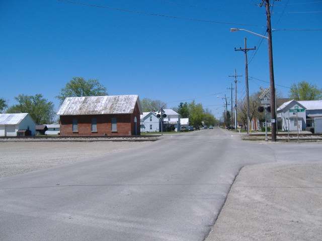
Photo: Aesopposea, via Wikimedia Commons, CC BY-SA 3.0 · Wikimedia Commons
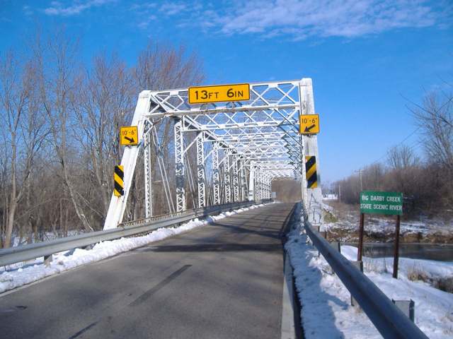
Photo: Aesopposea, via Wikimedia Commons, CC BY-SA 3.0 · Wikimedia Commons
Local history sources: archive.org · en.wikipedia.org · en.wikipedia.org · en.wikipedia.org · en.wikipedia.org · commons.wikimedia.org · commons.wikimedia.org
Water
Mostly private wells The water here
- Mount Sterling Village49% of residentsGroundwater wells (3 wells)
- Commercial Point Village18% of residentsGroundwater wells (6 wells)
- Village of Orient13% of residentsGroundwater wells (7 wells)
- Columbus Public Water System7% of residentsScioto River (Griggs & O'Shaughnessy), Hoover Reservoir on Big Walnut Ck, plus wells
- Darbyville Village5% of residentsGroundwater wells (3 wells)
- Johnson Mobile Home Park3% of residentsGroundwater wells (2 wells)
- Sunset Mobile Home Park2% of residentsGroundwater wells (1 wells)
- Timberlake Water System2% of residentsGroundwater wells (2 wells)
Hospitals, fire stations and more
Inside Darby Township, Pickaway County's boundary: 1 fire or EMS station, 1 power plant, 1 poor-rated bridge and 8 spill cases. Press a pin or a name for its whole record and its source.
Fire and EMS stations (1)
-
Tri - County Joint Fire District Station 492Orient
- Address
- 12200 Center Drive, Orient, OH 43146
- Coordinates
- 39.77377, -83.16772
USGS National Map structures (source) ↗ Street map and directions ↗
Source: USGS National Map structures (most Ohio records last updated 2019 to 2022), checked against the Columbus and Cleveland station lists. The department that answers a call is set by jurisdiction and mutual aid, not by distance.
Power plants (1)
-
Darby Power, LLC 100 MW or moreNatural gas · 480 MW
- Capacity
- 480 MW
- Main source
- Natural gas
- Technology
- Natural Gas Fired Combustion Turbine
- Operator
- Darby Power, LLC
- Sector
- IPP Non-CHP
- Where
- Mt Sterling, Pickaway County
- Generating units
- 6
- Built
- 2001 (first unit); newest unit 2002
- EIA plant code
- 55247
EIA plant page ↗ EIA-860 (source) ↗ Street map and directions ↗
Source: EIA-860 power plant inventory via HIFLD (February 2025), with plant codes, units and years from EIA-860 2025.
Bridges rated poor (1)
-
I-71 over Opossum RunPoor · built 1964
- Condition
- Poor: a deck, superstructure, substructure or culvert rated 4 or below on the 0 to 9 scale
- What it is
- Bridge
- Built
- 1964
- Length
- 36 ft
- Owner
- State
- Vehicles a day
- 20,873
- Coordinates
- 39.78939, -83.23817
National Bridge Inventory (source) ↗ Street map and directions ↗
Source: FHWA National Bridge Inventory 2025. "Poor" means one major part rated 4 or below on the 0 to 9 scale; it calls for repair, not closing, unless the state posts or closes the bridge.
Spills reported since 2021 (8)
-
Oil Hydraulic Fluid(S)2025-07-17 · Darby Twp
- Reported
- 2025-07-17
- What spilled
- Oil Hydraulic Fluid(S)
- Where
- Darby Twp, Pickaway County
- Ohio EPA district office
- CDO
- Ohio EPA case number
- 2507EPA0001187
Ohio EPA spill reports (source) ↗ Street map and directions ↗
-
Oil Motor / Lube Oil / Vehicle2025-01-30 · Darby Twp
- Reported
- 2025-01-30
- What spilled
- Oil Motor / Lube Oil / Vehicle
- Where
- Darby Twp, Pickaway County
- Ohio EPA district office
- CDO
- Ohio EPA case number
- 2501EPA0000122
Ohio EPA spill reports (source) ↗ Street map and directions ↗
-
Fuel Diesel / Diesel Fuel (Vehicle On Or Off Road)2025-01-09 · Darby Twp
- Reported
- 2025-01-09
- What spilled
- Fuel Diesel / Diesel Fuel (Vehicle On Or Off Road)
- Largest amount reported
- 100 gallons
- Where
- Darby Twp, Pickaway County
- Ohio EPA district office
- CDO
- Ohio EPA case number
- 2501EPA0000032
Ohio EPA spill reports (source) ↗ Street map and directions ↗
-
Fuel Diesel / Diesel Fuel (Vehicle On Or Off Road)2024-02-15 · Darby Twp
- Reported
- 2024-02-15
- What spilled
- Fuel Diesel / Diesel Fuel (Vehicle On Or Off Road)
- Where
- Darby Twp, Pickaway County
- Ohio EPA district office
- CDO
- Ohio EPA case number
- 2402EPA0000248
Ohio EPA spill reports (source) ↗ Street map and directions ↗
-
Oil Motor / Lube Oil / Vehicle2022-05-13 · Darby Twp
- Reported
- 2022-05-13
- What spilled
- Oil Motor / Lube Oil / Vehicle
- Where
- Darby Twp, Pickaway County
- Ohio EPA district office
- CDO
- Ohio EPA case number
- 2205EPA0000698
Ohio EPA spill reports (source) ↗ Street map and directions ↗
-
Oil Motor / Lube Oil / Vehicle2022-05-13 · Darby Twp
- Reported
- 2022-05-13
- What spilled
- Oil Motor / Lube Oil / Vehicle
- Where
- Darby Twp, Pickaway County
- Ohio EPA district office
- CDO
- Ohio EPA case number
- 2205EPA0000696
Ohio EPA spill reports (source) ↗ Street map and directions ↗
-
Oil Hydraulic Fluid(S)2022-01-14 · Darby Twp
- Reported
- 2022-01-14
- What spilled
- Oil Hydraulic Fluid(S)
- Largest amount reported
- 10 gallons
- Where
- Darby Twp, Pickaway County
- Ohio EPA district office
- CDO
- Ohio EPA case number
- 2201EPA0000044
Ohio EPA spill reports (source) ↗ Street map and directions ↗
-
Fuel Diesel / Diesel Fuel (Vehicle On Or Off Road)2021-12-08 · Darby Twp
- Reported
- 2021-12-08
- What spilled
- Fuel Diesel / Diesel Fuel (Vehicle On Or Off Road)
- Largest amount reported
- 75 gallons
- Where
- Darby Twp, Pickaway County
- Ohio EPA district office
- CDO
- Ohio EPA case number
- 2112EPA0001823
Ohio EPA spill reports (source) ↗ Street map and directions ↗
Source: Ohio EPA emergency response spill reports, 2021 to September 2026, one point per case where Ohio EPA placed it. A report is what the caller or responder recorded; amounts are often blank or estimated.
Its ZIP codes
Each ZIP code that touches Darby Township, Pickaway County, with the share of its residents who live here and the same headline figures as the ZIP page.
| ZIP | Share | Water | Radon | Home value | Schools | Flood |
|---|---|---|---|---|---|---|
| 43117 Darby Township and Derby | 100% | Mostly private wells | 10.7 pCi/L average radon | Median year built 1900 | Westfall Local · 3 stars overall | 0.0% of residents in the 1% floodplain |
| 43146 Scioto Township and Orient | 21% | Mostly private wells | 8.0 pCi/L average radon | Median year built 1988 | Teays Valley Local · 4 stars overall | 1.4% of residents in the 1% floodplain |
| 43143 Mount Sterling | 8% | Mostly private wells | 5.3 pCi/L average radon | Median year built 1968 | Madison-Plains Local · 4 stars overall | 3.4% of residents in the 1% floodplain |
Local government
Who holds office in Darby Township, Pickaway County, how its elections and ballot issues came out, and the state auditor's record.
Elections for office
| Date | Office | Candidates and votes |
|---|---|---|
| 2023-11-07 | Township Trustee | Thomas Doyle 379, 39.64%; Rob McNeal 577, 60.36% |
| 2017-11-07 | Township Trustee | James M Corder 436, 37.62%; Chris Creamer" 421, 36.32%; Richard Graham 302, 26.06% |
| 2015-11-03 | Township Trustee | Rick Graham 263, 29.45%; Ned A. Musselman 449, 50.28%; Clyde Ohnewehr 181, 20.27% |
Winners in bold. Results from the county board of elections' official canvass unless marked.
Auditor of State record
- No fiscal caution, watch or emergency on the Auditor of State's lists.
- Financial Audit, 2023 to 2024, released 2026-06-09
The county
Pickaway County: 8 ZIP codes, 22 cities, villages and townships, 56,176 people.
Nearby places
Quick answers
What county is Darby Township, Ohio in?
Darby Township, Pickaway County is a township in Pickaway County, Ohio, with 3,208 residents.
When was Darby Township, Ohio founded?
Darby Township, Pickaway County was settled c. 1800-1802 (the Poulson brothers -- Andrew, Cornelius, John, Elijah and William -- from Virginia); incorporated organized May 10, 1803, as the second township of Franklin County (boundaries then differed from today's); became a township of Pickaway County when the county was formed in 1810. Founders on record: the Associate Judges of the Franklin County Court of Common Pleas. Source
How did Darby Township, Ohio get its name?
Both the township and Darby Creek, which forms its eastern boundary, take their name from a Native chief remembered in the 1880 county history only as 'Darby.' That history's account of neighboring Muhlenberg Township, through which the same creek flows and where the village of Darbyville stands, describes the area as 'the home of the Shawnee Indians' and locates 'the camp and burial place of the band to which the chief, Darby, belonged' on the creek near Darbyville. Source
What ZIP code is Darby Township, Ohio?
Darby Township, Pickaway County is served by ZIP codes 43117, 43146 and 43143; 43117 holds the largest share of its residents.
Where does Darby Township, Ohio get its water?
The main water source for Darby Township, Pickaway County (Mount Sterling Village): Mostly private wells.
Cite this page
Cite this page as:
Cracked Buckeye, "Darby Township, Pickaway County", https://crackedbuckeye.com/place/darby-township-pickaway-county/, built 2026-10-31, accessed [date].
How to cite · Report a correction · Built 2026-10-31
