Local events in Mount Sterling
Mount Sterling itself has 1 event posted in the next 90 days; the others here are within 20 miles. All local events in Mount Sterling
Checked October 20; the events page is refreshed daily.
Lakes near Mount Sterling
The history under the water: the valley before, the dam, the stories. All Ohio lakes
History from Mount Sterling
People and inventions tied to this place, each with its sources. All people · All inventions
How Mount Sterling began
Mount Sterling grew up on a bluff over Deer Creek in southeastern Madison County, laid out in 1826 or 1828 by John J. Smith of Mount Sterling, Kentucky, who platted the town and named it for his hometown. A post office followed in 1830 and the village incorporated on March 12, 1845. It grew slowly through the nineteenth century, reaching a peak of prosperity between 1880 and 1900, helped by the Columbus and Midland Railway that reached it in 1884, and its downtown blocks are now protected as a National Register historic district. It remains a small agricultural trade town, home in 2020 to 1,945 people.
Settled 1797, platted 1826 or 1828, incorporated 1845-03-12, by John J. Smith, Esq., of Mount Sterling, Kentucky.
Where the name comes from
John J. Smith platted the village on a bluff above Deer Creek and named it after his own hometown of Mount Sterling, Kentucky. The plat was recorded at London on June 26, 1829.
Before the town
No village or camp specific to the Mount Sterling site is recorded in the sources checked. The county as a whole was Shawnee and Wyandot hunting ground before white settlement; Deer Creek, which runs past the village bluff, was known to Native people as prime deer-hunting country and is generally said to take its English name from that use. Jonathan Alder, taken captive by Shawnee raiders in Virginia in 1782 and raised by a Mingo family, hunted and lived across this part of central Ohio before settling permanently near Plain City after the 1795 Treaty of Greenville; his life is the best-documented Native-adjacent history for Madison County generally.
Nations recorded here: Shawnee, Wyandot, Mingo (Seneca-Cayuga).
Timeline
- — John J. Smith of Mount Sterling, Kentucky, platted the village on a bluff over Deer Creek; the plat was recorded at London on June 26, 1829.
- — A post office opened with Rowland Wilson as first postmaster; it closed in November 1831 and reopened April 6, 1832.
- — Mount Sterling incorporated as a village; its first municipal election was held August 15, 1845, electing Lewis Timmons mayor.
- — The Columbus and Midland Railway reached Mount Sterling, giving the farm town a rail link that spurred its late-nineteenth-century growth.
- — The Mount Sterling Historic District, covering blocks of N. London Street, was listed on the National Register of Historic Places.
- — Village administrator Joe Johnson was arrested for fraud and theft exceeding $1 million from village funds; he was later convicted and sentenced to more than ten years.
Stories
A Kentucky name for an Ohio bluff
In the 1820s John J. Smith bought a tract of land on the high ground overlooking Deer Creek in southeastern Madison County. Rather than invent a name, he reached back to his own hometown of Mount Sterling, Kentucky, and gave it to the new Ohio village he laid out on the bluff. The plat was formally recorded at the county seat in London on June 26, 1829. It was a common pattern on the Ohio frontier: settlers naming new towns for the places, often in Kentucky, Virginia, or Pennsylvania, that they had left behind.
Boom years and a modern reckoning
Mount Sterling's population climbed from just 118 people in 1850 to its historic peak between 1880 and 1900, helped along by the arrival of the Columbus and Midland Railway in 1884 and a downtown that by 1875 supported three churches, a bank, several stores, two blacksmith shops, and a carriage works; by 1915 it had electricity, municipal waterworks, grain elevators, and even an opera house. That long, orderly growth makes a sharp contrast with the village's twenty-first-century troubles: budget cuts stripped most of the paid police force in 2011, a 2012 Taser incident involving a nine-year-old drew national attention, and in 2016 the village's own administrator, Joe Johnson, was arrested and later convicted for stealing more than a million dollars from village accounts.
Photographs
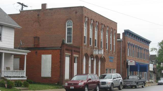
Photo: Nyttend, Wikimedia Commons, public domain · Wikimedia Commons
Local history sources: en.wikipedia.org · en.wikipedia.org · en.wikipedia.org · en.wikipedia.org · commons.wikimedia.org
Historic places
1 place in Mount Sterling on the National Register of Historic Places. Press a pin or a name for its whole record.
-
Mount Sterling Historic DistrictHistoric district · Mount Sterling · listed 1974
- Address
- Both sides of London St.
- Where
- Mount Sterling, Madison County · ZIP 43143
- What it is
- Historic district
- Listed on the National Register
- 1974
- NRIS reference number
- 74001559
- Coordinates
- 39.72020, -83.26490
National Register file (NPS) ↗ Search Wikipedia ↗ Street map and directions ↗ On the Cracked Buckeye map
Source: National Park Service, National Register of Historic Places point file. The listing year is shown where NPS's certification date agrees with the listing's reference number. Listing recognizes significance; it does not restrict a private owner.
Water
Mostly private wells The water here
- Mount Sterling Village96% of residentsGroundwater wells (3 wells)
- Sunset Mobile Home Park4% of residentsGroundwater wells (1 wells)
Hospitals, fire stations and more
Inside Mount Sterling's boundary: 1 fire or EMS station, 2 libraries, 3 Toxics Release Inventory facilities and 1 spill case. Press a pin or a name for its whole record and its source.
Fire and EMS stations (1)
-
Tri - County Joint Fire District Station 491Mount Sterling
- Address
- 7 West Columbus Street, Mount Sterling, OH 43143
- Coordinates
- 39.71883, -83.26524
USGS National Map structures (source) ↗ Street map and directions ↗
Source: USGS National Map structures (most Ohio records last updated 2019 to 2022), checked against the Columbus and Cleveland station lists. The department that answers a call is set by jurisdiction and mutual aid, not by distance.
Public libraries (2)
-
Mt Sterling Public LibraryCentral library · Mt. Sterling
- Address
- 60 W. Columbus St., Mt. Sterling, OH 43143
- What it is
- Central library
- Library system
- Mt Sterling Public Library
- Open
- 2,184 hours a year, 52 weeks
- Building
- 8,360 sq ft
- System's visits, FY2024
- 5,876
- System's loans, FY2024
- 23,703
- People the system serves
- 13,303
- Phone
- (740) 869-2430
IMLS Public Libraries Survey (source) ↗ Street map and directions ↗
-
Mt Sterling Public Library BsBookmobile stop · Mt Sterling
- Address
- 60 W Columbus St, Mt Sterling, OH 43143
- What it is
- Bookmobile stop
- Library system
- Mt Sterling Public Library
- System's visits, FY2024
- 5,876
- System's loans, FY2024
- 23,703
- People the system serves
- 13,303
- Phone
- (740) 869-2430
IMLS Public Libraries Survey (source) ↗ Street map and directions ↗
Source: IMLS Public Libraries Survey FY2024 (outlets and their systems). Any Ohio resident can get a free card at any Ohio public library.
Facilities reporting toxic releases (3)
-
Mahle Behr Mt Sterling IncToxics Release Inventory · Mount Sterling
- Address
- 10500 O'Day-Harrison Rd, Mount Sterling, OH 43143
- County
- Madison County
- Status
- Reports to the Toxics Release Inventory (active)
- EPA program ID
- 4314WKHNTH15DAY
- EPA registry ID
- 110046123823
EPA facility record ↗ EPA Facility Registry Service (source) ↗ Street map and directions ↗
-
Mahle Behr Mt. Sterling Inc.Toxics Release Inventory · Mount Sterling
- Address
- 10500 Oday Harrison Rd, Mount Sterling, OH 43143
- County
- Madison County County
- Status
- Reports to the Toxics Release Inventory (***unchanged***)
- EPA program ID
- 4314WMHLBH15DAY
- EPA registry ID
- 110071163504
EPA facility record ↗ EPA Facility Registry Service (source) ↗ Street map and directions ↗
-
Royster-Clark IncToxics Release Inventory · Mount Sterling
- Address
- 249 W. Chestnut St., Mount Sterling, OH 43143
- County
- Madison County
- Status
- Reports to the Toxics Release Inventory (active)
- EPA program ID
- 43143RYSTR249WC
- EPA registry ID
- 110042042571
EPA facility record ↗ EPA Facility Registry Service (source) ↗ Street map and directions ↗
Source: EPA Facility Registry Service, Toxics Release Inventory reporters. Reporting a release is required of large users of listed chemicals; it is not by itself a violation.
Spills reported since 2021 (1)
-
Oil Motor / Lube Oil / Vehicle2025-07-03 · Mt Sterling
- Reported
- 2025-07-03
- What spilled
- Oil Motor / Lube Oil / Vehicle
- Where
- Mt Sterling, Madison County
- Ohio EPA district office
- SWDO
- Ohio EPA case number
- 2507EPA0001108
Ohio EPA spill reports (source) ↗ Street map and directions ↗
Source: Ohio EPA emergency response spill reports, 2021 to September 2026, one point per case where Ohio EPA placed it. A report is what the caller or responder recorded; amounts are often blank or estimated.
Its ZIP codes
Each ZIP code that touches Mount Sterling, with the share of its residents who live here and the same headline figures as the ZIP page.
| ZIP | Share | Water | Radon | Home value | Schools | Flood |
|---|---|---|---|---|---|---|
| 43143 Mount Sterling | 33% | Mostly private wells | 5.3 pCi/L average radon | Median year built 1968 | Madison-Plains Local · 4 stars overall | 3.4% of residents in the 1% floodplain |
Local government
Who holds office in Mount Sterling, how its elections and ballot issues came out, and the state auditor's record.
Elections for office
| Date | Office | Candidates and votes |
|---|---|---|
| 2021-11-02 | Member of Council | Shawnee Corbin 150, 15.69%; Andrew Drake 179, 18.72%; Craig Hix 133, 13.91%; Robert Longcoy 164, 17.15%; Becky Martin 158, 16.53%; William D. Tilley 172, 17.99% |
| 2019-11-05 | Member of Council | Lowell G. Anderson 70, 13.75%; Andrew Drake 91, 17.88%; Jordan Pettey 200, 39.29%; David Timmons 148, 29.08% |
| 2019-11-05 | Mayor | Marci L. Darlington 177, 57.28%; Rebecca Lenn Martin 66, 21.36%; William Martin 66, 21.36% |
Winners in bold. Results from the county board of elections' official canvass unless marked.
Auditor of State record
- Fiscal emergency: declared 2017-06-22, released 2022-10-11. source
- Financial Audit, 2024 to 2025, released 2026-09-03
- Financial Audit, 2022 to 2023, released 2025-05-08
The county
Madison County: 6 ZIP codes, 19 cities, villages and townships, 38,669 people.
Nearby places
Rain and snow
How much has actually fallen on Mount Sterling, day by day, from 1893 to now. Daily totals, not averages.
- rain, last 30 days
- 0.82 in
- 2026-09-30 to 2026-10-29
- rain so far in 2026
- 44.3 in
- 8.5 in above normal for the date
- snow so far in 2026
- 18.8 in
- a normal year brings 18.5 in
- a normal year
- 42.0 in
- average of 30 years, 1991-2020
| Month | Rain (in) | Snow (in) | Days counted |
|---|---|---|---|
| October 2026 | 0.82 | — | 29 |
| September 2026 | 6.70 | — | 30 |
| August 2026 | 8.52 | — | 31 |
| July 2026 | 4.10 | — | 31 |
| June 2026 | 3.40 | — | 30 |
| May 2026 | 6.57 | — | 31 |
| April 2026 | 3.36 | — | 30 |
| March 2026 | 7.14 | 1.8 | 31 |
| February 2026 | 2.15 | 3.9 | 28 |
| January 2026 | 1.50 | 13.1 | 31 |
| December 2025 | 2.31 | 10.3 | 31 |
| November 2025 | 2.53 | 1.9 | 30 |
| Wettest year | 2018 — 57.1 in |
|---|---|
| Driest year | 1930 — 23.6 in |
| Snowiest year | 1910 — 46.8 in |
| Wettest day on record | 14 September 1979 — 4.46 in |
| Heaviest snowfall in a day | 26 November 1950 — 11.11 in |
| Deepest snow on the ground | 14 April 1916 — 30.00 in |
Estimated, not measured. No rain gauge has ever stood inside Mount Sterling, so every figure here is worked out from the gauges around it - the nearest ones weighted most. Treat them as close estimates rather than readings.
48,875 days of records, 1893-01-01 to 2026-10-29. Source: NOAA NCEI GHCN-Daily, 3,240 gauges in and around Ohio. A day is "gauged" when a gauge standing inside the boundary reported it, and the value is the mean of those gauges. Otherwise it is interpolated by inverse distance from every gauge reporting within 50 miles. Nothing is carried forward, back-filled or smoothed. Against NOAA nClimDiv county monthly precipitation over 136,848 complete county-months (checked 2026-10-31): correlation 0.9515, median absolute difference 0.217 in a month. Built 2026-10-31 from the Cracked Buckeye precipitation archive. Snow is the softer number — snowfall is measured by hand with a ruler, no agency publishes a gridded county snowfall series, and blowing snow defeats every observer.
Environmental permits and filings
What Ohio EPA has on file for Mount Sterling: permits, inspections, violations, cleanups and the state loans behind sewer and water work. Every line links to the agency's own document.
- facilities and sites on file
- 31
- those placed on the map inside Mount Sterling
| Program | Facilities and sites |
|---|---|
| Wastewater and stormwater discharge | 10 |
| Air pollution | 4 |
| Hazardous waste | 4 |
| State water loans | 3 |
| Site assessment | 2 |
| Chemical accident plans | 1 |
| Contaminated-site cleanup | 1 |
| Public drinking water | 1 |
| Sewer and water-line construction | 1 |
| Source-water protection | 1 |
| State sewer loans | 1 |
| Underground injection wells | 1 |
| 1 smaller programs |
| Date | Facility or site | What |
|---|---|---|
| MOUNT STERLING VILLAGE PWS | Public drinking water inspection | |
| MOUNT STERLING VILLAGE PWS | Public drinking water compliance letter | |
| MOUNT STERLING VILLAGE PWS | Public drinking water compliance letter | |
| MOUNT STERLING VILLAGE PWS | Public drinking water report | |
| CDBG SPRING STREET SANITARY SEWER | Sewer and water-line construction permit | |
| MOUNT STERLING VILLAGE PWS | Public drinking water plan | |
| MOUNT STERLING VILLAGE PWS | Public drinking water violation resolved | |
| MOUNT STERLING VILLAGE PWS | Public drinking water inspection | |
| MOUNT STERLING VILLAGE PWS | Public drinking water notice of violation | |
| CDBG SPRING STREET SANITARY SEWER | Sewer and water-line construction permit | |
| MOUNT STERLING VILLAGE PWS | Public drinking water inspection | |
| MOUNT STERLING VILLAGE PWS | Public drinking water notice of violation | |
| MOUNT STERLING VILLAGE PWS | Public drinking water notice of violation | |
| MOUNT STERLING VILLAGE PWS | Public drinking water inspection | |
| MAHLE BEHR MT STERLING INC | Wastewater and stormwater discharge report | |
| MAHLE BEHR MT STERLING INC | Wastewater and stormwater discharge report | |
| MOUNT STERLING VILLAGE PWS | Public drinking water warning letter | |
| MAHLE BEHR MT STERLING INC | Wastewater and stormwater discharge report | |
| MAHLE BEHR MT STERLING INC | Wastewater and stormwater discharge report | |
| PICWAY-MADISON LINE (STRS 1-108) REBUILD | Wastewater and stormwater discharge permit | |
| MAHLE BEHR MT STERLING INC | Wastewater and stormwater discharge report | |
| BASIL | Wastewater and stormwater discharge permit | |
| MAHLE BEHR MT STERLING INC | Wastewater and stormwater discharge report | |
| MOUNT STERLING VILLAGE PWS | Public drinking water report | |
| MAHLE BEHR MT STERLING INC | Wastewater and stormwater discharge inspection |
Source: Ohio EPA eDocument portal (edocpub.epa.ohio.gov), indexed 2026-10-14. Facilities are placed on the map from Ohio EPA's own map layers, EPA's Facility Registry, coordinates written in the filings, or a geocoded street address. A permit filed under a private person's name (most are household septic systems) is counted but never named, placed or linked; licenses for individual workers and open-burning notices are left out entirely.
Quick answers
What county is Mount Sterling, Ohio in?
Mount Sterling is a village in Madison County, Ohio, with 1,945 residents.
When was Mount Sterling, Ohio founded?
Mount Sterling was settled 1797; laid out 1826 or 1828; incorporated 1845-03-12. Founders on record: John J. Smith, Esq., of Mount Sterling, Kentucky. Source
How did Mount Sterling, Ohio get its name?
John J. Source
What ZIP code is Mount Sterling, Ohio?
Most of Mount Sterling is in ZIP code 43143.
Where does Mount Sterling, Ohio get its water?
The main water source for Mount Sterling (Mount Sterling Village): Mostly private wells.
Cite this page
Cite this page as:
Cracked Buckeye, "Mount Sterling, Madison County", https://crackedbuckeye.com/place/mount-sterling/, built 2026-10-31, accessed [date].
How to cite · Report a correction · Built 2026-10-31
