Local events in Jefferson Township, Coshocton County
Nothing is posted for Jefferson Township itself yet; here is what is on within 20 miles. All local events in Jefferson Township, Coshocton County
Know a calendar we should watch? Send the link
Checked October 20; the events page is refreshed daily.
How Jefferson Township, Coshocton County began
Jefferson Township straddles the Walhonding River in northwestern Coshocton County. Its hills hold ancient flint workings and a stone mound that the 1881 county history ascribed to a lost prehistoric people. Colonel William Simmons's military section and the Bell section were laid out in 1800, and the Darling, Elder and Butler families from Virginia settled the river bottoms from 1806. The township was organized in 1826. Warsaw was laid out in 1834 beside the Walhonding Canal, and Mohawk village (locally 'Jericho') was platted in 1859 at the height of a cannel-coal oil boom. The Mohawk Dam, a flood-control dam northwest of Nellie, was built here in 1935-37. The Warsaw Hotel was listed on the National Register in 1994, and the township had 1,461 residents in 2020.
Settled 1806, platted 1834 (Warsaw); 1859 (Mohawk village), incorporated 1826 (township organized), by Darling, Elder and Butler families (1806); Col. William Simmons (Simmons section, about 1819).
Where the name comes from
The township was named for Thomas Jefferson, one of twenty-four Ohio townships bearing his name; no source ties the choice to a specific local event. Warsaw, the township's larger village, was named after Warsaw, the capital of Poland.
Before the town
The 1881 county history opens its chapter on Jefferson Township with the traces of a 'primitive race.' On the farms of Col. Pren Metham, R. B. Whitaker and Mrs. Criss, in the south-central part of the township, seams of flint four to six feet wide had been mined from many hills; the work left ridges that some took for fortifications, cave-like openings with ashes and charcoal, and heaps of large scarred river boulders that the author supposed were hurled against flint heated by fire and then cracked by water. Piles of flint chips, finished and unfinished arrowheads and spear-heads lay near the workings, and the engineer Colonel Castell estimated that doing the work then, in 1881, would cost not less than $1,000,000. East of Metham's house a stone mound about 18 feet across and 5 feet high, built in layers of sandstone, was opened in 1855 by Rev. Boggs and Colonel Metham and held a stone-slab vault with part of a skeleton the diggers thought was over seven feet tall; across the river on Robert Darling's farm a semicircular stone wall about 30 feet across crowned a sandstone ridge. The 1881 author attributed all of this to a vanished race of Mound Builders and compared the teeth to those of an 'Aztec race,' which reflects 19th-century theories; no later study of these sites is cited in the sources reviewed, and no nation is named. For historic times the 1881 history says Abner Meredith, an early settler near Mohawk, was on friendly terms with the Native people and hunted with them up the Killbuck, and tells of an evening at which they sent to Coshocton for whisky and he slipped away. The Walhonding valley was Lenape (Delaware) territory into the 1780s.
- Prehistoric flint workings (other) — Hills on the Metham, Whitaker and Criss farms, south-central Jefferson Township, undated; attributed in 1881 to a prehistoric people (archive.org)
- Stone mound east of the Metham residence (mound) — Hilltop east of Col. Pren Metham's house, Jefferson Township, undated; explored 1855 (archive.org)
- Semicircular stone wall on a sandstone ridge (earthwork) — Robert Darling's farm, ridge above the Walhonding, Jefferson Township, undated (archive.org)
Timeline
- — Col. William Simmons locates the eastern military section, the 'Simmons section,' and the Bell section's patent is granted on April 2 to Cairnon Wedwell, who conveys it to John Duncan and then John Bell of Philadelphia.
- — Silas Bent Jr. surveys the northern half of the township as congress land.
- — Robert Darling, his wife and twelve children, John Elder and Joseph Butler arrive from Virginia; the Darlings settle in the bend of the river north of the Walhonding, and the eldest daughter, Mary, aged eighteen, drives a four-horse team over the mountains.
- — Isaac Butler drowns crossing the ford near his house, probably the first death in the township.
- — Oliver Remington of Rhode Island teaches what is probably the township's first school, in the former Butler cabin, in 1814 or 1815.
- — Pren Metham, agent for the Bell section's owner John Bell, moves to the township.
- — Jefferson Township is established as a civil township of Coshocton County.
- — Payne Clark, hunting a hearth-stone for his new cabin on the Simmons section, brings home a slab of cannel coal; a big fire on it makes the slab burn, and he has to find another hearth-stone; this is how the township's cannel-coal field is discovered.
- — The village of Warsaw is laid out within the township.
- — Jefferson Presbyterian Church is organized by Rev. Nathaniel Conklin, with 24 members; the same year a Scotch-Irish colony from Tyrone, Ireland, via Marshall County, Virginia, buys the remaining 2,200 acres of the Bell section.
- — Jefferson Regular Baptist Church is organized in May, and the Mohawk village church in the fall, the latter by Rev. Harvey D. Camp for the Irish families who settled the Mohawk valley.
- — German settlers in the northeast organize the Zion Evangelical Lutheran and Reformed church and build a log meeting-house with their own hands.
- — About this year, twenty-five years after Payne Clark's discovery, a cannel-coal oil boom begins; at least six companies set up retorts in the southern part of the township before the boom collapses a few years later.
- — William and James Thompson lay out Mohawk village, which the coal-oil excitement fills for about eighteen months; each original lot deed forbids the sale of liquor on pain of forfeiture, a clause the courts later uphold. Locally the village is called Jericho.
- — Construction of the Mohawk Dam begins in April; the dry dam, finished in September 1937 across the right-of-way of the Walhonding Canal, is one of 14 flood-control dams in the Muskingum watershed.
- — The Warsaw Hotel, in Warsaw village, is added to the National Register of Historic Places (March 17).
- — The census counts 1,461 people in Jefferson Township.
Stories
The coal-oil bubble and the village called Jericho
In 1832 Payne Clark, hunting a hearth-stone for his new cabin in the Simmons section, found a slab of black cannel coal, carried it home and built a fire on it; it burned, and Clark had to find another stone. Twenty-five years later fortunes were spent on the same coal. Around 1857 at least six companies, from New York, Pennsylvania, Newark and Dresden, as well as a Home Company of local men, set up retorts on the Lyman, Wood, Moore and Given farms to distil coal oil, and William and James Thompson laid out Mohawk village in 1859 to house the workers; each lot deed barred the sale of liquor on pain of forfeiture, a clause the courts upheld. About eighteen months later the bubble burst, and the village barely held its own, with about 75 people in 1881. Its everyday name, Jericho, is said to come from an Irishman who, after a quarrel with a Scottish school director, read a paper before the local literary society describing how, going down from Jerusalem to Jericho, he fell among thieves, and the audience was so pleased that the name stuck.
Mary Darling drives the wagon
When Robert Darling and his wife and twelve children left Virginia for the Walhonding valley in 1806, two of the sons, Jonathan and William, went ahead in the spring to raise a crop of corn. In the fall the rest of the family crossed the mountains, with Mary Darling, then eighteen, driving a four-horse team loaded with the family goods and her mother riding horseback with an infant in front and a small boy, Thomas, holding on behind. They settled in the bend north of the river on the Bell section, land that has stayed in the Darling name. Mary later married Nicholas Miller of Keene Township, and her brother Thomas served as county commissioner and raised blooded cattle; Jonathan and William served in the War of 1812, and their younger brother Abram once rode to their camp at Sandusky to bring them stockings. The Darlings' generosity to the German canal workers who settled the rough northern hills in the 1830s, who often asked for corn in midwinter and paid in labor, was long remembered at the polls.
Photographs
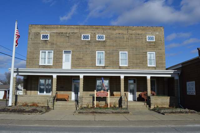
Photo: Nyttend, public domain · Wikimedia Commons
Local history sources: en.wikipedia.org · en.wikipedia.org · en.wikipedia.org · commons.wikimedia.org · archive.org · en.wikipedia.org · en.wikipedia.org
Water
Mostly private wells The water here
- Warsaw100% of residentsGroundwater wells (2 wells)
Hospitals, fire stations and more
Inside Jefferson Township, Coshocton County's boundary: 1 high-hazard dam and 1 museum. Press a pin or a name for its whole record and its source.
High-hazard dams (1)
-
Mohawk DamWalhonding River · condition: not available
- Hazard class
- High: a failure would probably cost a life
- Condition
- Not Available
- River or stream
- Walhonding River
- Purpose
- Flood Risk Reduction
- Type
- Rockfill
- Height
- 111 ft
- Storage
- 285,000 acre-feet
- Completed
- 1937
- Owner type
- Federal
- County
- Coshocton County
- Nearest town (NID)
- Warsaw
- Last inspection
- 11/20/2025
- Emergency action plan
- Yes
- NID ID
- OH00016
National Inventory of Dams record ↗ National Inventory of Dams (source) ↗ Street map and directions ↗
Source: U.S. Army Corps of Engineers National Inventory of Dams, August 2026. "High hazard" rates what a failure would cost downstream, not how likely one is; the condition is the state's assessment.
Museums, historical societies, gardens and zoos (1)
-
Walhonding Valley Historical SocietyHistorical society · Warsaw
- What it is
- Historical society
- City
- Warsaw
- Coordinates
- 40.32504, -82.03707
Search Wikipedia ↗ IMLS Museum Data Files (source) ↗ Street map and directions ↗
The museum list is IMLS's 2018 file; a museum may have closed or moved since.
Source: IMLS Museum Data Files, 2018.
Its ZIP codes
Each ZIP code that touches Jefferson Township, Coshocton County, with the share of its residents who live here and the same headline figures as the ZIP page.
| ZIP | Share | Water | Radon | Home value | Schools | Flood |
|---|---|---|---|---|---|---|
| 43844 Jefferson Township and Warsaw | 19% | Mostly private wells | 16.6 pCi/L average radon | Median year built 1979 | River View Local · 3 stars overall | 6.7% of residents in the 1% floodplain |
Local government
Who holds office in Jefferson Township, Coshocton County, how its elections and ballot issues came out, and the state auditor's record.
Money issues on the ballot since 2019: 1 of 1 passed.
Ballot issues
| Date | Issue | For | Against | Result |
|---|---|---|---|---|
| 2019-11-05 | Issue 5: Jefferson Township (levy type not on the results report) | 299 | 190 | Passed (61.15% for) |
Elections for office
| Date | Office | Candidates and votes |
|---|---|---|
| 2019-11-05 | Township Trustee | John Hartsock 422, 100.0% |
| 2019-11-05 | Township Fiscal Officer | Sandy Fitch 421, 100.0% |
Winners in bold. Results from the county board of elections' official canvass unless marked.
Auditor of State record
- No fiscal caution, watch or emergency on the Auditor of State's lists.
- Basic Audit, 2023 to 2024, released 2025-05-20
The county
Coshocton County: 8 ZIP codes, 25 cities, villages and townships, 33,626 people.
Nearby places
Quick answers
What county is Jefferson Township, Ohio in?
Jefferson Township, Coshocton County is a township in Coshocton County, Ohio, with 705 residents.
When was Jefferson Township, Ohio founded?
Jefferson Township, Coshocton County was settled 1806; laid out 1834 (Warsaw); 1859 (Mohawk village); incorporated 1826 (township organized). Founders on record: Darling, Elder and Butler families (1806); Col. William Simmons (Simmons section, about 1819). Source
How did Jefferson Township, Ohio get its name?
The township was named for Thomas Jefferson, one of twenty-four Ohio townships bearing his name; no source ties the choice to a specific local event. Source
What ZIP code is Jefferson Township, Ohio?
Most of Jefferson Township, Coshocton County is in ZIP code 43844.
Where does Jefferson Township, Ohio get its water?
The main water source for Jefferson Township, Coshocton County (Warsaw): Mostly private wells.
Cite this page
Cite this page as:
Cracked Buckeye, "Jefferson Township, Coshocton County", https://crackedbuckeye.com/place/jefferson-township-coshocton-county/, built 2026-10-31, accessed [date].
How to cite · Report a correction · Built 2026-10-31