Local events in Warsaw
Warsaw itself has 2 events posted in the next 90 days; the others here are within 20 miles. All local events in Warsaw
Checked October 20; the events page is refreshed daily.
How Warsaw began
Warsaw sits on the Walhonding River in western Coshocton County. William Carhart, a general of the Ohio militia in the War of 1812 and son-in-law of Revolutionary War colonel William Simmons, whose land grant covered the site, built the first house here several years before he laid out 32 lots on his own land on November 13, 1834 and named the village for the Polish capital, in sympathy with the failed 1830-31 uprising against Russian rule. The Walhonding Canal, dug past the village from 1836 to 1842, brought a second addition of lots, taverns and a five-story flour mill powered by canal water; by about 1881 Warsaw had 275 residents, a two-story school (1871), a Methodist church and a foundry. A railroad followed the canal route in the 1890s. The Warsaw Hotel, built in 1906 on East Main Street, was listed on the National Register in 1994, and the village had 634 residents in 2020.
Settled before 1834 (William Carhart's house, the first building), platted November 13, 1834, by William Carhart, son-in-law of Col. William Simmons.
Where the name comes from
Named for Warsaw, the capital of Poland, 'through sympathy with her earnest though ineffectual struggle for liberty,' in the words of the 1881 county history. Wikipedia ties the choice to the November 1830 uprising of Polish military cadets against Russian rule.
Before the town
No Native American site or event specific to the village of Warsaw is recorded in the sources checked. Warsaw sits on the Walhonding River, a corridor of Delaware (Lenape) and other Native travel and settlement in the 1700s. Coshocton County's wider record includes the Lenape capital Goschachgunk at the forks of the Muskingum, the Bouquet expedition of 1764 that met just below the forks, and White Woman's Town at the Killbuck-Walhonding junction. The 1881 county history describes ancient flint workings, a stone mound and a stone wall elsewhere in Jefferson Township, the township that holds Warsaw, and says Abner Meredith, an early settler near Mohawk, hunted with Native people up the Killbuck.
Nations recorded here: Lenape (Delaware).
Timeline
- — William Carhart plats 32 lots on his own homestead on the Walhonding River and founds Warsaw, naming it for the Polish capital.
- — William Carhart lays out Warsaw, 32 lots on both sides of Main Street, around his own house, which had been built several years earlier and is the first building on the site; John Collins keeps the first store and Major William Long soon opens a second.
- — Construction begins on the Walhonding Canal, which is finished in 1842 and runs from Roscoe past Warsaw to Cavallo as a feeder of the Ohio and Erie Canal.
- — During canal construction Rufus Eldredge adds 41 lots facing Church Street and opens a tavern; William Long begins the five-story canal-powered flour mill, finished after his death by Nichols and Porter Rector.
- — A large two-story frame schoolhouse with high-school, secondary and primary departments is built, replacing a one-room school.
- — The county history counts 275 residents, two physicians, several stores, a foundry and carriage shops, the Sherman House hotel and one church, the Methodist Episcopal.
- — The Pennsylvania Company organizes the Walhonding Valley Railroad to follow the canal route from Coshocton to Loudonville; it is finished four years later and its use of abandoned canal land leads to a legal dispute with the state.
- — The Warsaw Hotel is built at 102 East Main Street.
- — The Warsaw Hotel is listed on the National Register of Historic Places (March 17).
- — The census counts 634 people in Warsaw.
Stories
A treasury officer's land grant and a Polish uprising
The land Warsaw stands on traces to a 4,000-acre grant President John Adams made in 1800 to William Simmons, a Revolutionary War colonel who had been one of five men George Washington appointed to organize the first United States Treasury. Simmons's daughter Josephine married William Carhart, a general who helped organize the Ohio militia during the War of 1812. In November 1834 Carhart laid out 32 lots on his own land here. Half a world away that same era, young cadets at the Warsaw military academy had risen against Russian rule in November 1830; although that revolt was crushed and Polish independence was another 85 years off, Carhart named his new Walhonding River village Warsaw in its honor.
The Warsaw Hotel
Built in 1906-07 on East Main Street, the Warsaw Hotel served travelers and townspeople through the twentieth century and remains the village's most visible historic landmark. It was added to the National Register of Historic Places on March 17, 1994.
An open bar for the canal diggers
When the Walhonding Canal was being dug past Warsaw in the late 1830s, Rufus Eldredge opened a tavern in the little village, and on the first day, as was the custom, the bar was open and everyone was invited to drink free. The 1881 county history says most people in the neighborhood spent a lively day at it. The road up the Walhonding was thick with taverns then. Two miles west, Eckman's tavern served as the township's election house, and a teamster hauling wheat to Coshocton would stop there, then at Warsaw, then at Nathan Spencer's in Bethlehem Township, with the same round in reverse on the way home. The canal route ran straight through the site of Eckman's, so the building was torn down and the state paid its owner for his three acres. By 1881, the historian thought, it would be hard to find two gallons of whisky in the whole valley outside the few saloons.
Photographs
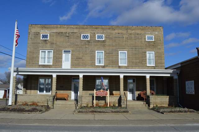
Photo: Nyttend, public domain · Wikimedia Commons
Local history sources: en.wikipedia.org · hmdb.org · hmdb.org · commons.wikimedia.org · commons.wikimedia.org · archive.org · en.wikipedia.org
Historic places
1 place in Warsaw on the National Register of Historic Places. Press a pin or a name for its whole record.
-
Warsaw HotelBuilding · Warsaw · listed 1994
- Address
- 102 E. Main St.
- Where
- Warsaw, Coshocton County · ZIP 43844
- What it is
- Building
- Listed on the National Register
- 1994
- NRIS reference number
- 94000244
- Coordinates
- 40.33539, -82.00571
National Register file (NPS) ↗ Search Wikipedia ↗ Street map and directions ↗ On the Cracked Buckeye map
Source: National Park Service, National Register of Historic Places point file. The listing year is shown where NPS's certification date agrees with the listing's reference number. Listing recognizes significance; it does not restrict a private owner.
Water
Mostly private wells The water here
- Warsaw100% of residentsGroundwater wells (2 wells)
Hospitals, fire stations and more
Inside Warsaw's boundary: 1 fire or EMS station and 1 public school. Press a pin or a name for its whole record and its source.
Fire and EMS stations (1)
-
Walhonding Valley Fire DepartmentWarsaw
- Address
- 100 South Bridge Street, Warsaw, OH 43844
- Coordinates
- 40.33458, -82.00653
USGS National Map structures (source) ↗ Street map and directions ↗
Source: USGS National Map structures (most Ohio records last updated 2019 to 2022), checked against the Columbus and Cleveland station lists. The department that answers a call is set by jurisdiction and mutual aid, not by distance.
Public schools (1)
-
River View Elementary School1 of 5 stars · Warsaw
- Address
- 501 Blissfield Road, Warsaw, OH 43844
- School district
- River View Local School District
- Kind (NCES)
- Regular School
- Students, 2023-24
- 411
- Teachers (full-time equivalent)
- 25
- Report card, 2025-26
- 1 of 5 stars
- Ohio building IRN
- 039289
- NCES school ID
- 390464802573
NCES school record ↗ Ohio School Report Card ↗ Street map and directions ↗
Source: NCES EDGE public school locations 2024-25 and Common Core of Data 2023-24 (type, students, teachers); Ohio School Report Cards 2025-26 (Department of Education and Workforce), matched by name within the district.
Its ZIP codes
Each ZIP code that touches Warsaw, with the share of its residents who live here and the same headline figures as the ZIP page.
| ZIP | Share | Water | Radon | Home value | Schools | Flood |
|---|---|---|---|---|---|---|
| 43844 Jefferson Township and Warsaw | 17% | Mostly private wells | 16.6 pCi/L average radon | Median year built 1979 | River View Local · 3 stars overall | 6.7% of residents in the 1% floodplain |
Local government
Who holds office in Warsaw, how its elections and ballot issues came out, and the state auditor's record.
Elections for office
| Date | Office | Candidates and votes |
|---|---|---|
| 2019-11-05 | Member of Council | Corey L. Fischer 167, 48.83%; Jesse M. Fischer 175, 51.17% |
Winners in bold. Results from the county board of elections' official canvass unless marked.
Auditor of State record
- No fiscal caution, watch or emergency on the Auditor of State's lists.
- Agreed Upon Procedures, 2023 to 2024, released 2025-12-23
The county
Coshocton County: 8 ZIP codes, 25 cities, villages and townships, 33,626 people.
Nearby places
Rain and snow
How much has actually fallen on Warsaw, day by day, from 1887 to now. Daily totals, not averages.
- rain, last 30 days
- 1.05 in
- 2026-09-30 to 2026-10-29
- rain so far in 2026
- 42.1 in
- 6.1 in above normal for the date
- snow so far in 2026
- 23.4 in
- a normal year brings 23.9 in
- a normal year
- 42.4 in
- average of 30 years, 1991-2020
| Month | Rain (in) | Snow (in) | Days counted |
|---|---|---|---|
| October 2026 | 1.05 | — | 29 |
| September 2026 | 5.72 | — | 30 |
| August 2026 | 8.93 | — | 31 |
| July 2026 | 3.56 | — | 31 |
| June 2026 | 3.36 | — | 30 |
| May 2026 | 6.21 | — | 31 |
| April 2026 | 3.50 | — | 30 |
| March 2026 | 5.79 | 1.9 | 31 |
| February 2026 | 1.69 | 3.3 | 28 |
| January 2026 | 2.29 | 18.3 | 31 |
| December 2025 | 2.98 | 12.2 | 31 |
| November 2025 | 2.53 | 0.1 | 30 |
| Wettest year | 2018 — 56.5 in |
|---|---|
| Driest year | 1930 — 22.1 in |
| Snowiest year | 1910 — 59.0 in |
| Wettest day on record | 7 August 1935 — 5.39 in |
| Heaviest snowfall in a day | 22 April 1901 — 16.54 in |
| Deepest snow on the ground | 10 November 1913 — 21.00 in |
Estimated, not measured. No rain gauge has ever stood inside Warsaw, so every figure here is worked out from the gauges around it - the nearest ones weighted most. Treat them as close estimates rather than readings.
49,712 days of records, 1887-08-01 to 2026-10-29. Source: NOAA NCEI GHCN-Daily, 3,240 gauges in and around Ohio. A day is "gauged" when a gauge standing inside the boundary reported it, and the value is the mean of those gauges. Otherwise it is interpolated by inverse distance from every gauge reporting within 50 miles. Nothing is carried forward, back-filled or smoothed. Against NOAA nClimDiv county monthly precipitation over 136,848 complete county-months (checked 2026-10-31): correlation 0.9515, median absolute difference 0.217 in a month. Built 2026-10-31 from the Cracked Buckeye precipitation archive. Snow is the softer number — snowfall is measured by hand with a ruler, no agency publishes a gridded county snowfall series, and blowing snow defeats every observer.
Environmental permits and filings
What Ohio EPA has on file for Warsaw: permits, inspections, violations, cleanups and the state loans behind sewer and water work. Every line links to the agency's own document.
- facilities and sites on file
- 3
- those placed on the map inside Warsaw
| Program | Facilities and sites |
|---|---|
| Hazardous waste | 1 |
| State water loans | 1 |
| Underground injection wells | 1 |
| Date | Facility or site | What |
|---|---|---|
| WARSAW PWS | State water loans | |
| WARSAW PWS | State water loans | |
| WARSAW PWS | State water loans | |
| WARSAW PWS | State water loans | |
| CHEVRON SITE #352877 | Underground injection wells inspection | |
| CHEVRON SITE #352877 | Underground injection wells monitoring results | |
| WARSAW PWS | State water loans |
Source: Ohio EPA eDocument portal (edocpub.epa.ohio.gov), indexed 2026-10-14. Facilities are placed on the map from Ohio EPA's own map layers, EPA's Facility Registry, coordinates written in the filings, or a geocoded street address. A permit filed under a private person's name (most are household septic systems) is counted but never named, placed or linked; licenses for individual workers and open-burning notices are left out entirely.
Quick answers
What county is Warsaw, Ohio in?
Warsaw is a village in Coshocton County, Ohio, with 634 residents.
When was Warsaw, Ohio founded?
Warsaw was settled before 1834 (William Carhart's house, the first building); laid out November 13, 1834. Founders on record: William Carhart, son-in-law of Col. William Simmons. Source
How did Warsaw, Ohio get its name?
Named for Warsaw, the capital of Poland, 'through sympathy with her earnest though ineffectual struggle for liberty,' in the words of the 1881 county history. Source
What ZIP code is Warsaw, Ohio?
Most of Warsaw is in ZIP code 43844.
Where does Warsaw, Ohio get its water?
The main water source for Warsaw (Warsaw): Mostly private wells.
Cite this page
Cite this page as:
Cracked Buckeye, "Warsaw, Coshocton County", https://crackedbuckeye.com/place/warsaw/, built 2026-10-31, accessed [date].
How to cite · Report a correction · Built 2026-10-31
