Local events in Ashtabula
32 events in the next 90 days from 4 public calendars. All local events in Ashtabula
Checked October 20; the events page is refreshed daily.
Lakes near Ashtabula
The history under the water: the valley before, the dam, the stories. All Ohio lakes
History from Ashtabula
People and inventions tied to this place, each with its sources. All people · All inventions
How Ashtabula began
Ashtabula grew up around its Lake Erie harbor, first surveyed as a Great Lakes port and settled from the 1800s by families tied to Connecticut Western Reserve land agent Nehemiah Hubbard. His descendant William Hubbard built a house near the harbor in the 1840s that became one of the region's best-documented Underground Railroad stations, sheltering dozens of freedom seekers before their crossing to Canada. By the late nineteenth century the harbor had grown into one of the world's largest iron-ore and coal ports, feeding Great Lakes steel mills and drawing Finnish, Swedish, and Italian immigrant communities to the Harbor district; the city incorporated in 1891. Ashtabula is also forever tied to the catastrophic collapse of a nearby railroad bridge in 1876, one of the deadliest disasters in American railroad history.
Settled 1803 (area settlement begins), incorporated 1891 (city), by Connecticut Western Reserve settlers; Hubbard family prominent among early landowners.
Where the name comes from
Ashtabula takes its name from the Ashtabula River, itself from a Lenape (Delaware) phrase reconstructed as *ashte-pihële*, "always enough (fish) to go around".
Before the town
No Native American village, trail, mound, or site specific to the city of Ashtabula itself is documented in the sources consulted; the county's Whittlesey-culture and Beaver Wars-era history is centered further west and east, at Conneaut.
Timeline
- — European American settlement of the area that becomes Ashtabula begins, following the Western Reserve's survey and the Treaty of Greenville's earlier clearing of Native title.
- — The Hubbard family, descendants of Western Reserve land agent Nehemiah Hubbard, establish a residence at the harbor that is later converted into the Ohio Exchange hotel as the port develops.
- — William Hubbard joins the Ashtabula County Anti-Slavery Society shortly after arriving, beginning decades of Underground Railroad work from the family home near the harbor.
- — The Ashtabula River railroad bridge collapses beneath the Pacific Express during a blizzard on December 29, killing roughly 92 people just outside the town.
- — Ashtabula incorporates as a city.
- — Sovinto Hall, a Finnish temperance and cultural hall described as the largest wooden structure in Ohio, is built in the Harbor district to serve the port's Finnish immigrant community; it stood until its demolition in 1961.
- — The first electrically welded steel-hulled ship in the world is built at Ashtabula Harbor.
- — The Ashtabula Harbor Commercial District is listed on the National Register of Historic Places.
- — The city's population peaks at about 24,300 before a long industrial decline; the 2020 census records 17,975 residents.
Stories
Mother Hubbard's Cupboard
William Hubbard, a descendant of the Connecticut land agent Nehemiah Hubbard, built a house near Ashtabula's harbor in the 1840s and joined the county's Anti-Slavery Society soon after settling there. The house became known among freedom seekers as "Mother Hubbard's Cupboard" or "The Great Emporium" -- a place that always seemed to have room for one more. Escaped slaves who had made their way north, often after crossing the Ohio River far to the south, would be sheltered in the house before walking a quarter mile to the Hubbard and Company warehouse on the Ashtabula River, where friendly boat captains waited to carry them across Lake Erie to Canada. At least one account records the house sheltering thirty-nine escaped people at a single time. William Hubbard also helped found the Ashtabula Sentinel, an abolitionist newspaper, giving the movement both a station and a voice in the same family. The house survived a scheduled demolition in 1979 through the efforts of a small preservation group that included Hubbard's own great-great-grandson, and today operates as the Hubbard House Underground Railroad Museum.
Photographs
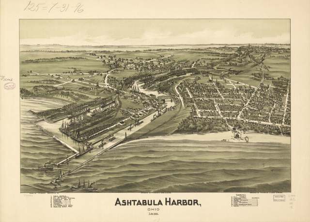
Photo: Library of Congress Geography and Map Division, via Wikimedia Commons, Public domain · Wikimedia Commons
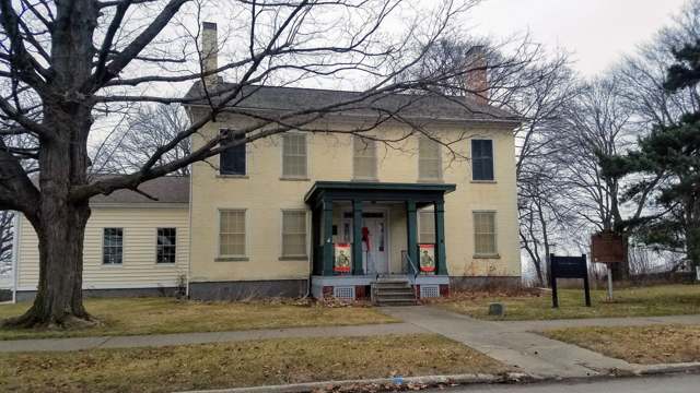
Photo: Upstateherd, via Wikimedia Commons, Wiki Loves Monuments 2021, CC BY-SA 4.0 · Wikimedia Commons
Local history sources: en.wikipedia.org · en.wikipedia.org · historicashtabulaharbor.org · en.wikipedia.org · commons.wikimedia.org · commons.wikimedia.org
Historic places
8 places in Ashtabula on the National Register of Historic Places. Press a pin or a name for its whole record.
-
Ashtabula Harbour Commercial DistrictHistoric district · Ashtabula · listed 1975
- Address
- Both sides of W. 5th St. from 1200 block to Ashtabula River
- Where
- Ashtabula, Ashtabula County · ZIP 44004
- What it is
- Historic district
- Listed on the National Register
- 1975
- NRIS reference number
- 75001311
- Coordinates
- 41.89961, -80.79945
National Register file (NPS) ↗ Search Wikipedia ↗ Street map and directions ↗ On the Cracked Buckeye map
-
Ashtabula Post Office and Federal BuildingBuilding · Ashtabula
- Address
- 4400 Main Ave.
- Where
- Ashtabula, Ashtabula County · ZIP 44004
- What it is
- Building
- Latest NPS certification action
- 2019
- NRIS reference number
- 100004053
- Coordinates
- 41.86514, -80.78137
National Register file (NPS) ↗ Search Wikipedia ↗ Street map and directions ↗ On the Cracked Buckeye map
-
Cahill, Michael, HouseBuilding · Ashtabula · listed 1988
- Address
- 1106 Walnut Blvd.
- Where
- Ashtabula, Ashtabula County · ZIP 44004
- What it is
- Building
- Listed on the National Register
- 1988
- NRIS reference number
- 88001711
- Coordinates
- 41.90098, -80.80051
National Register file (NPS) ↗ Search Wikipedia ↗ Street map and directions ↗ On the Cracked Buckeye map
-
Castle BlockBuilding · Ashtabula
- Address
- 323-355 Center St.
- Where
- Ashtabula, Ashtabula County · ZIP 44004
- What it is
- Building
- Latest NPS certification action
- 2020
- NRIS reference number
- 100005127
- Coordinates
- 41.86510, -80.78525
National Register file (NPS) ↗ Search Wikipedia ↗ Street map and directions ↗ On the Cracked Buckeye map
-
Hotel AshtabulaBuilding · Ashtabula · listed 1985
- Address
- 4726 Main Ave.
- Where
- Ashtabula, Ashtabula County · ZIP 44004
- What it is
- Building
- Listed on the National Register
- 1985
- NRIS reference number
- 85001342
- Coordinates
- 41.86400, -80.78245
National Register file (NPS) ↗ Search Wikipedia ↗ Street map and directions ↗ On the Cracked Buckeye map
-
Hubbard, Col. William, HouseBuilding · Ashtabula · listed 1973
- Address
- Corner of Lake Ave. and Walnut Blvd.
- Where
- Ashtabula, Ashtabula County · ZIP 44004
- What it is
- Building
- Listed on the National Register
- 1973
- NRIS reference number
- 73001385
- Coordinates
- 41.89971, -80.80463
National Register file (NPS) ↗ Search Wikipedia ↗ Street map and directions ↗ On the Cracked Buckeye map
-
Mother of Sorrows ChurchBuilding · Ashtabula · listed 1995
- Address
- 1500 W. 6th St.
- Where
- Ashtabula, Ashtabula County · ZIP 44004
- What it is
- Building
- Listed on the National Register
- 1995
- NRIS reference number
- 95000170
- Coordinates
- 41.89583, -80.80356
National Register file (NPS) ↗ Search Wikipedia ↗ Street map and directions ↗ On the Cracked Buckeye map
-
West Fifth Street BridgeStructure · Ashtabula · listed 1985
- Address
- SR 531 over Ashtabula River
- Where
- Ashtabula, Ashtabula County · ZIP 44004
- What it is
- Structure
- Listed on the National Register
- 1985
- NRIS reference number
- 85001801
- Coordinates
- 41.90042, -80.79776
National Register file (NPS) ↗ Search Wikipedia ↗ Street map and directions ↗ On the Cracked Buckeye map
Source: National Park Service, National Register of Historic Places point file. The listing year is shown where NPS's certification date agrees with the listing's reference number. Listing recognizes significance; it does not restrict a private owner.
Water
Lake Erie, drawn at a shoreline intake near Ashtabula Harbor into a plant that sits only about 4 feet above lake water elevation The water here
- Aqua Ohio - Ashtabula100% of residentsLake Erie
Hospitals, fire stations and more
Inside Ashtabula's boundary: 1 hospital, 3 health centers, 1 dialysis center, 2 nursing homes, 1 fire or EMS station, 1 college, 5 public schools, 2 libraries, 5 museums, 1 police station, 7 Superfund sites, 18 Toxics Release Inventory facilities and 18 spill cases. Press a pin or a name for its whole record and its source.
Hospitals (1)
-
Ashtabula Co. Medical CenterGeneral hospital · Ashtabula
- What it is
- General hospital
- Address
- 2420 Lake Avenue, Ashtabula, OH 44004
- County
- Ashtabula County
- Beds
- 234
- Helipad
- Yes
- Ownership
- Non-profit
- Medicare overall rating
- 3 of 5 stars
- Emergency department (Medicare)
- Yes
- Medicare reports it as
- Ashtabula County Medical Center
- Phone
- (440) 997-2262
- Medicare ID
- 360125
Medicare Care Compare ↗ Where HIFLD got this record ↗ HIFLD hospitals (source) ↗ Street map and directions ↗
Source: HIFLD hospitals inventory via FEMA (closed hospitals it still lists left out, hospitals opened since added), with Medicare Care Compare ratings matched by name and address.
Community health centers (3)
-
SHI Ashtabula Family Health CenterHealth center · Ashtabula
- Run by
- a federally qualified health center
- Setting
- Clinic
- City
- Ashtabula
- Coordinates
- 41.86724, -80.78624
Find a Health Center (HRSA) ↗ HRSA data (source) ↗ Street map and directions ↗
-
Signature Health Ashtabula Health CenterHealth center · Ashtabula
- Run by
- a federally qualified health center
- Setting
- Clinic
- City
- Ashtabula
- Coordinates
- 41.86403, -80.78236
Find a Health Center (HRSA) ↗ HRSA data (source) ↗ Street map and directions ↗
-
Signature Health Mobile ClinicHealth center · Ashtabula
- Run by
- a federally qualified health center
- Setting
- Clinic
- City
- Ashtabula
- Coordinates
- 41.86403, -80.78236
Find a Health Center (HRSA) ↗ HRSA data (source) ↗ Street map and directions ↗
Source: HRSA health center service delivery sites, active, September 2026 (school-based sites left out). Health centers see patients whether or not they have insurance, with fees on a sliding scale.
Dialysis centers (1)
-
Davita Ashtabula DialysisDialysis · Ashtabula
- Address
- 1614 West 19Th Street, Ashtabula, OH 44004
- Dialysis stations
- 17
- Medicare star rating
- 3 of 5 stars
- Services
- in-center hemodialysis, peritoneal dialysis
- Ownership
- for profit
- Chain
- DaVita
- Medicare certified since
- 1996-03-31
- Phone
- (440) 964-9777
- Medicare ID
- 362554
Medicare Care Compare ↗ CMS dialysis facility list (source) ↗ Street map and directions ↗
Source: CMS dialysis facility list, September 2026, geocoded with the Census Bureau batch geocoder (an address it could not place sits at its ZIP center).
Nursing homes (2)
-
Carington Park5 of 5 stars · Ashtabula
- Address
- 2217 West Ave, Ashtabula, OH 44004
- Certified beds
- 175
- Residents on an average day
- 152
- Medicare overall rating
- 5 of 5 stars
- Health inspections
- 5 of 5 stars
- Staffing
- 2 of 5 stars
- Penalties since 2023
- none
- Ownership
- For profit - Corporation
- Chain
- FOUNDATIONS HEALTH SOLUTIONS
- Takes
- Medicare and Medicaid
- Phone
- (440) 964-8446
- Medicare ID
- 365286
Medicare Care Compare ↗ CMS nursing home data (source) ↗ Street map and directions ↗
-
Country Club Ret Center I I I4 of 5 stars · Ashtabula
- Address
- 925 E 26Th St, Ashtabula, OH 44004
- Certified beds
- 73
- Residents on an average day
- 71
- Medicare overall rating
- 4 of 5 stars
- Health inspections
- 3 of 5 stars
- Staffing
- 2 of 5 stars
- Quality measures
- 5 of 5 stars
- Penalties since 2023
- none
- Ownership
- For profit - Corporation
- Chain
- COUNTRY CLUB REHABILITATION CAMPUS
- Continuing care retirement community
- Yes
- Takes
- Medicare and Medicaid
- Phone
- (440) 992-0022
- Medicare ID
- 365642
Medicare Care Compare ↗ CMS nursing home data (source) ↗ Street map and directions ↗
Source: CMS Care Compare nursing home provider and penalties files; Medicare star ratings run 1 to 5.
Fire and EMS stations (1)
-
Ashtabula Fire DepartmentAshtabula
- Address
- 4326 Main Avenue, Ashtabula, OH 44004
- Coordinates
- 41.86807, -80.78082
USGS National Map structures (source) ↗ Street map and directions ↗
Source: USGS National Map structures (most Ohio records last updated 2019 to 2022), checked against the Columbus and Cleveland station lists. The department that answers a call is set by jurisdiction and mutual aid, not by distance.
Colleges (1)
-
Kent State University at AshtabulaRegional campus of a public university · Ashtabula
- What it is
- Regional campus of a public university
- City
- Ashtabula
- Students, 2023-24 (12-month count)
- 2,840
- Tuition and fees, in state
- $7,272
- Tuition and fees, out of state
- $16,744
- Graduation rate
- 23% of bachelor's students, within six years (a class of 108)
- IPEDS unit ID
- 203447
College Navigator (NCES) ↗ IPEDS data (source) ↗ Street map and directions ↗
Source: NCES IPEDS 2024 directory, 2023-24 enrollment and tuition, graduation rates for the 2017 (four-year) and 2020 (two-year) entering classes.
Public schools (5)
-
Erie Intermediate School3 of 5 stars · Ashtabula
- Address
- 2306 Wade Ave, Ashtabula, OH 44004
- School district
- Ashtabula Area City School District
- Kind (NCES)
- Regular School
- Students, 2023-24
- 391
- Teachers (full-time equivalent)
- 17
- Report card, 2025-26
- 3 of 5 stars
- Performance index
- 54.3%
- Ohio building IRN
- 033670
- NCES school ID
- 390435100090
NCES school record ↗ Ohio School Report Card ↗ Street map and directions ↗
-
Huron Primary SchoolAshtabula
- Address
- 2300 Wade Ave, Ashtabula, OH 44004
- Kind (NCES)
- Regular School
- Students, 2023-24
- 127
- Teachers (full-time equivalent)
- 5
- NCES school ID
- 390435100093
-
Michigan Primary School1.5 of 5 stars · Ashtabula
- Address
- 2304 Wade Ave, Ashtabula, OH 44004
- School district
- Ashtabula Area City School District
- Kind (NCES)
- Regular School
- Students, 2023-24
- 393
- Teachers (full-time equivalent)
- 23
- Report card, 2025-26
- 1.5 of 5 stars
- Ohio building IRN
- 035873
- NCES school ID
- 390435100091
NCES school record ↗ Ohio School Report Card ↗ Street map and directions ↗
-
Ontario Primary School4 of 5 stars · Ashtabula
- Address
- 2302 Wade Ave, Ashtabula, OH 44004
- School district
- Ashtabula Area City School District
- Kind (NCES)
- Regular School
- Students, 2023-24
- 219
- Teachers (full-time equivalent)
- 13
- Report card, 2025-26
- 4 of 5 stars
- Ohio building IRN
- 004242
- NCES school ID
- 390435100088
NCES school record ↗ Ohio School Report Card ↗ Street map and directions ↗
-
Superior Intermediate School2.5 of 5 stars · Ashtabula
- Address
- 2308 Wade Ave, Ashtabula, OH 44004
- School district
- Ashtabula Area City School District
- Kind (NCES)
- Regular School
- Students, 2023-24
- 423
- Teachers (full-time equivalent)
- 21
- Report card, 2025-26
- 2.5 of 5 stars
- Performance index
- 55.4%
- Ohio building IRN
- 011518
- NCES school ID
- 390435105520
NCES school record ↗ Ohio School Report Card ↗ Street map and directions ↗
Source: NCES EDGE public school locations 2024-25 and Common Core of Data 2023-24 (type, students, teachers); Ohio School Report Cards 2025-26 (Department of Education and Workforce), matched by name within the district.
Public libraries (2)
-
Ashtabula County District LibraryCentral library · Ashtabula
- Address
- 4335 Park Ave, Ashtabula, OH 44004
- What it is
- Central library
- Library system
- Ashtabula County District Library
- Open
- 3,071 hours a year, 52 weeks
- Building
- 38,307 sq ft
- System's visits, FY2024
- 196,924
- System's loans, FY2024
- 251,619
- People the system serves
- 48,578
- Phone
- (440) 997-9341
IMLS Public Libraries Survey (source) ↗ Street map and directions ↗
-
Harbor-Topky Memorial LibraryCentral library · Ashtabula Harbor
- Address
- 1633 Walnut Blvd., Ashtabula Harbor, OH 44004
- What it is
- Central library
- Library system
- Harbor-Topky Memorial Library
- Open
- 2,288 hours a year, 52 weeks
- Building
- 10,000 sq ft
- System's visits, FY2024
- 29,848
- System's loans, FY2024
- 89,320
- People the system serves
- 1,744
- Phone
- (440) 964-9645
IMLS Public Libraries Survey (source) ↗ Street map and directions ↗
Source: IMLS Public Libraries Survey FY2024 (outlets and their systems). Any Ohio resident can get a free card at any Ohio public library.
Museums, historical societies, gardens and zoos (5)
-
Ashtabula Arts CenterArt museum · Ashtabula
- What it is
- Art museum
- City
- Ashtabula
- Coordinates
- 41.88767, -80.82348
Search Wikipedia ↗ IMLS Museum Data Files (source) ↗ Street map and directions ↗
The museum list is IMLS's 2018 file; a museum may have closed or moved since.
-
Ashtabula Marine MuseumMuseum · Ashtabula
- What it is
- Museum
- City
- Ashtabula
- Coordinates
- 41.90118, -80.80038
Search Wikipedia ↗ IMLS Museum Data Files (source) ↗ Street map and directions ↗
The museum list is IMLS's 2018 file; a museum may have closed or moved since.
-
Ashtabula Maritime & Surface Transportation MuseumScience or technology museum · Ashtabula
- What it is
- Science or technology museum
- City
- Ashtabula
- Coordinates
- 41.90118, -80.80038
Search Wikipedia ↗ IMLS Museum Data Files (source) ↗ Street map and directions ↗
The museum list is IMLS's 2018 file; a museum may have closed or moved since.
-
Finnish American Heritage AssociationHistory museum · Ashtabula
- What it is
- History museum
- City
- Ashtabula
- Coordinates
- 41.89768, -80.79851
Search Wikipedia ↗ IMLS Museum Data Files (source) ↗ Street map and directions ↗
The museum list is IMLS's 2018 file; a museum may have closed or moved since.
-
Hubbard House Underground Railroad MuseumMuseum · Ashtabula
- What it is
- Museum
- City
- Ashtabula
- Coordinates
- 41.87600, -80.80005
Search Wikipedia ↗ IMLS Museum Data Files (source) ↗ Street map and directions ↗
The museum list is IMLS's 2018 file; a museum may have closed or moved since.
Source: IMLS Museum Data Files, 2018.
Police stations (1)
-
Ashtabula Police DepartmentAshtabula
- Address
- 110 West 44th Street, Ashtabula, OH 44004
- Coordinates
- 41.86693, -80.78019
USGS National Map structures (source) ↗ Street map and directions ↗
Source: USGS National Map structures, police stations, corrected and completed by hand (September 2026). The department that answers a call is set by jurisdiction, not by distance.
Superfund sites (7)
-
Ashtabula Iron and MetalSuperfund program · Ashtabula
- Address
- 1015 West 30Th St, Ashtabula, OH 44004
- County
- Ashtabula County
- Status
- Superfund program site, not on the National Priorities List
- EPA program ID
- OHN000510892
- EPA registry ID
- 110004738197
EPA facility record ↗ EPA Facility Registry Service (source) ↗ Street map and directions ↗
-
Carlisle Building SiteSuperfund program · Ashtabula
- Address
- 4509 Main Ave, Ashtabula, OH 44004
- County
- Ashtabula County
- Status
- Superfund program site, not on the National Priorities List
- EPA program ID
- OHN000507834
- EPA registry ID
- 110070490852
EPA facility record ↗ EPA Facility Registry Service (source) ↗ Street map and directions ↗
-
Park Haven Meth SiteSuperfund program · Ashtabula
- Address
- 4533 Park Avenue, Ashtabula, OH 44004
- County
- Ashtabula County
- Status
- Superfund program site, not on the National Priorities List
- EPA program ID
- OHN000510734
- EPA registry ID
- 110045395844
EPA facility record ↗ EPA Facility Registry Service (source) ↗ Street map and directions ↗
-
Raser Tanning CompanySuperfund program · Ashtabula
- Address
- 757 Prospect Rd, Ashtabula, OH 44004
- County
- Ashtabula County
- Status
- Superfund program site, not on the National Priorities List
- EPA program ID
- OHD980684526
- EPA registry ID
- 110004638624
EPA facility record ↗ EPA Facility Registry Service (source) ↗ Street map and directions ↗
-
Services Chem of OhioSuperfund program · Ashtabula
- Address
- 3404 Ann Ave, Ashtabula, OH 44004
- County
- Ashtabula County
- Status
- Superfund program site, not on the National Priorities List
- EPA program ID
- OHD980700934
- EPA registry ID
- 110000617538
EPA facility record ↗ EPA Facility Registry Service (source) ↗ Street map and directions ↗
-
Strongsbrook Pcb Spill SiteSuperfund program · Ashtabula
- Address
- 1302 West 38Th St., Ashtabula, OH 44004
- County
- Ashtabula County
- Status
- Superfund program site, not on the National Priorities List
- EPA program ID
- OHN000510216
- EPA registry ID
- 110031234420
EPA facility record ↗ EPA Facility Registry Service (source) ↗ Street map and directions ↗
-
West SchoolSuperfund program · Ashtabula
- Address
- 4601-4603 West Avenue, Ashtabula, OH 44004
- County
- Ashtabula County
- Status
- Superfund program site, not on the National Priorities List
- EPA program ID
- OHN000504425
- EPA registry ID
- 110067036120
EPA facility record ↗ EPA Facility Registry Service (source) ↗ Street map and directions ↗
Source: EPA Facility Registry Service, Superfund (SEMS) and National Priorities List sites. Many program sites were assessed and needed no cleanup.
Facilities reporting toxic releases (18)
-
Ashland Chemical IncToxics Release Inventory · Ashtabula
- Address
- 4501 Benefit Ave., Ashtabula, OH 44004
- County
- Ashtabula County
- Status
- Reports to the Toxics Release Inventory (closed)
- EPA program ID
- 44004SHLND4501B
- EPA registry ID
- 110000385084
EPA facility record ↗ EPA Facility Registry Service (source) ↗ Street map and directions ↗
-
Ashtabula Rubber Co IncToxics Release Inventory · Ashtabula
- Address
- 2751 West Ave., Ashtabula, OH 44004
- County
- Ashtabula County
- Status
- Reports to the Toxics Release Inventory (open)
- EPA program ID
- 44004SHTBL2751W
- EPA registry ID
- 110000385093
EPA facility record ↗ EPA Facility Registry Service (source) ↗ Street map and directions ↗
-
Iten Industries Inc. (Plant 3) (0204010442)Toxics Release Inventory · Ashtabula
- Address
- 1303 West 38Th Street, Ashtabula, OH 44004
- County
- Ashtabula County
- Status
- Reports to the Toxics Release Inventory (active)
- EPA program ID
- 44004TNNDS1303W
- EPA registry ID
- 110004589473
EPA facility record ↗ EPA Facility Registry Service (source) ↗ Street map and directions ↗
-
Iten Industries, Inc. - Plant 1 (0204010112)Toxics Release Inventory · Ashtabula
- Address
- 4001 Benefit Ave., Ashtabula, OH 44005
- County
- Ashtabula County
- Status
- Reports to the Toxics Release Inventory (active)
- EPA program ID
- 44004TNNDS4001B
- EPA registry ID
- 110000385100
EPA facility record ↗ EPA Facility Registry Service (source) ↗ Street map and directions ↗
-
Koski Construction Co (0204010008)Toxics Release Inventory · Ashtabula
- Address
- E Fifth St, Ashtabula, OH 44004
- County
- Ashtabula County
- Status
- Reports to the Toxics Release Inventory
- EPA program ID
- 4400WKSKCNEFIFT
- EPA registry ID
- 110070628944
EPA facility record ↗ EPA Facility Registry Service (source) ↗ Street map and directions ↗
-
Lake City Plating Plant 1Toxics Release Inventory · Ashtabula
- Address
- 1701 Lake Avenue, Ashtabula, OH 44004
- County
- Ashtabula County
- Status
- Reports to the Toxics Release Inventory (active)
- EPA program ID
- 44004LKCTY1701L
- EPA registry ID
- 110002110046
EPA facility record ↗ EPA Facility Registry Service (source) ↗ Street map and directions ↗
-
Lake City Plating Plant 2Toxics Release Inventory · Ashtabula
- Address
- 1700 Lake Ave, Ashtabula, OH 44004
- County
- Ashtabula County
- Status
- Reports to the Toxics Release Inventory
- EPA program ID
- 4400WLKCTY17LAK
- EPA registry ID
- 110031397138
EPA facility record ↗ EPA Facility Registry Service (source) ↗ Street map and directions ↗
-
Meese Orbitron Dunne CoToxics Release Inventory · Ashtabula
- Address
- 4920 State Rd, Ashtabula, OH 44004
- County
- Ashtabula County
- Status
- Reports to the Toxics Release Inventory (active)
- EPA program ID
- 44004DNNPL4920S
- EPA registry ID
- 110009678367
EPA facility record ↗ EPA Facility Registry Service (source) ↗ Street map and directions ↗
-
Mfg Water Treatment Products Company Inc.Toxics Release Inventory · Ashtabula
- Address
- 4621 Benefit Avenue, Ashtabula, OH 44004
- County
- Ashtabula County
- Status
- Reports to the Toxics Release Inventory (active)
- EPA program ID
- 44004MFGWT4621B
- EPA registry ID
- 110000385048
EPA facility record ↗ EPA Facility Registry Service (source) ↗ Street map and directions ↗
-
Molded Fiber Glass Companies, Plant 1Toxics Release Inventory · Ashtabula
- Address
- 4401 Benefit Avenue, Ashtabula, OH 44004
- County
- Ashtabula County
- Status
- Reports to the Toxics Release Inventory (active)
- EPA program ID
- 44004MLDDF4401B
- EPA registry ID
- 110000741779
EPA facility record ↗ EPA Facility Registry Service (source) ↗ Street map and directions ↗
-
Molded Fiber Glass Composite Systems CompanyToxics Release Inventory · Ashtabula
- Address
- 2925 Mfg Place, Ashtabula, OH 44004
- County
- Ashtabula County
- Status
- Reports to the Toxics Release Inventory (active)
- EPA program ID
- 44004MLDDF1601W
- EPA registry ID
- 110000385057
EPA facility record ↗ EPA Facility Registry Service (source) ↗ Street map and directions ↗
-
Molded Fiber Glass Research Company *Toxics Release Inventory · Ashtabula
- Address
- 1315 W. 47Th St., Ashtabula, OH 44004
- County
- Ashtabula County
- Status
- Reports to the Toxics Release Inventory (active)
- EPA program ID
- 44004MLDDF1315W
- EPA registry ID
- 110008057271
EPA facility record ↗ EPA Facility Registry Service (source) ↗ Street map and directions ↗
-
Reliance Business ParkToxics Release Inventory · Ashtabula
- Address
- 4200 Benefit Avenue, Ashtabula, OH 44004
- County
- Ashtabula County
- Status
- Reports to the Toxics Release Inventory (active)
- EPA program ID
- 44004RLNCL4200B
- EPA registry ID
- 110001617901
EPA facility record ↗ EPA Facility Registry Service (source) ↗ Street map and directions ↗
-
Usalco/ Delta Chemical CorpToxics Release Inventory · Ashtabula
- Address
- 1741 West 47Th Street, Ashtabula, OH 44004
- County
- Ashtabula County
- Status
- Reports to the Toxics Release Inventory (open)
- EPA program ID
- 44004DLTCH1741W
- EPA registry ID
- 110008057262
EPA facility record ↗ EPA Facility Registry Service (source) ↗ Street map and directions ↗
-
Vibrantz Color Solutions Inc. (0204010285)Toxics Release Inventory · Ashtabula
- Address
- 2600 Michigan Ave, Ashtabula, OH 44004
- County
- Ashtabula County
- Status
- Reports to the Toxics Release Inventory (active)
- EPA program ID
- 44004PLSTC2600M
- EPA registry ID
- 110000591636
EPA facility record ↗ EPA Facility Registry Service (source) ↗ Street map and directions ↗
-
Zehrco Giancola Composites IncToxics Release Inventory · Ashtabula
- Address
- 5500 Washington Ave., Ashtabula, OH 44004
- County
- Ashtabula County
- Status
- Reports to the Toxics Release Inventory (active)
- EPA program ID
- 44004ZHRCP5500W
- EPA registry ID
- 110000385119
EPA facility record ↗ EPA Facility Registry Service (source) ↗ Street map and directions ↗
-
Zehrco Giancola Composites Inc Plant 4Toxics Release Inventory · Ashtabula
- Address
- 4212 Ann Ave., Ashtabula, OH 44004
- County
- Ashtabula County
- Status
- Reports to the Toxics Release Inventory (active)
- EPA program ID
- 44004PCKNS4212A
- EPA registry ID
- 110001135682
EPA facility record ↗ EPA Facility Registry Service (source) ↗ Street map and directions ↗
-
Zehrco-Giancola Composites IncToxics Release Inventory · Ashtabula
- Address
- 1501 West 47Th Street, Ashtabula, OH 44004
- County
- Ashtabula County
- Status
- Reports to the Toxics Release Inventory (active)
- EPA program ID
- 44004ZRHCP1501W
- EPA registry ID
- 110000385128
EPA facility record ↗ EPA Facility Registry Service (source) ↗ Street map and directions ↗
Source: EPA Facility Registry Service, Toxics Release Inventory reporters. Reporting a release is required of large users of listed chemicals; it is not by itself a violation.
Spills reported since 2021 (18)
-
Sewage Sludge / Biosolids Reached water2025-10-12 · Ashtabula
- Reported
- 2025-10-12
- What spilled
- Sewage Sludge / Biosolids
- Reached a waterway
- 04 - Lake Erie
- Where
- Ashtabula, Ashtabula County
- Ohio EPA district office
- NEDO
- Ohio EPA case number
- 2510EPA0001682
Ohio EPA spill reports (source) ↗ Street map and directions ↗
-
Sewage Human2025-10-05 · Ashtabula
- Reported
- 2025-10-05
- What spilled
- Sewage Human
- Where
- Ashtabula, Ashtabula County
- Ohio EPA district office
- NEDO
- Ohio EPA case number
- 2510EPA0001645
Ohio EPA spill reports (source) ↗ Street map and directions ↗
-
Material Unknown2025-04-08 · Ashtabula
- Reported
- 2025-04-08
- What spilled
- Material Unknown
- Where
- Ashtabula, Ashtabula County
- Ohio EPA district office
- NEDO
- Ohio EPA case number
- 2504EPA0000528
Ohio EPA spill reports (source) ↗ Street map and directions ↗
-
Oil Transformer Non Pcb2025-01-11 · Ashtabula
- Reported
- 2025-01-11
- What spilled
- Oil Transformer Non Pcb
- Largest amount reported
- 30 gallons
- Where
- Ashtabula, Ashtabula County
- Ohio EPA district office
- NEDO
- Ohio EPA case number
- 2501EPA0000040
Ohio EPA spill reports (source) ↗ Street map and directions ↗
-
Fuel Diesel / Diesel Fuel (Vehicle On Or Off Road)2024-08-01 · Ashtabula
- Reported
- 2024-08-01
- What spilled
- Fuel Diesel / Diesel Fuel (Vehicle On Or Off Road)
- Where
- Ashtabula, Ashtabula County
- Ohio EPA district office
- NEDO
- Ohio EPA case number
- 2408EPA0001320
Ohio EPA spill reports (source) ↗ Street map and directions ↗
-
Hydrochloric Acid / Muriatic Acid (Hcl)2024-06-26 · Ashtabula
- Reported
- 2024-06-26
- What spilled
- Hydrochloric Acid / Muriatic Acid (Hcl)
- Where
- Ashtabula, Ashtabula County
- Ohio EPA district office
- NEDO
- Ohio EPA case number
- 2406EPA0001071
Ohio EPA spill reports (source) ↗ Street map and directions ↗
-
Sheen Rainbow / Hydrocarbon2024-03-15 · Ashtabula
- Reported
- 2024-03-15
- What spilled
- Sheen Rainbow / Hydrocarbon
- Where
- Ashtabula, Ashtabula County
- Ohio EPA district office
- NEDO
- Ohio EPA case number
- 2403EPA0000418
Ohio EPA spill reports (source) ↗ Street map and directions ↗
-
Methyl Alcohol / Methanol / Naphtha (Ch3Oh)2023-05-26 · Ashtabula
- Reported
- 2023-05-26
- What spilled
- Methyl Alcohol / Methanol / Naphtha (Ch3Oh)
- Largest amount reported
- 5 gallons
- Where
- Ashtabula, Ashtabula County
- Ohio EPA district office
- NEDO
- Ohio EPA case number
- 2305EPA0000867
Ohio EPA spill reports (source) ↗ Street map and directions ↗
-
Oil Motor / Lube Oil / Vehicle2023-03-06 · Ashtabula
- Reported
- 2023-03-06
- What spilled
- Oil Motor / Lube Oil / Vehicle
- Largest amount reported
- 2 gallons
- Where
- Ashtabula, Ashtabula County
- Ohio EPA district office
- NEDO
- Ohio EPA case number
- 2303EPA0000350
Ohio EPA spill reports (source) ↗ Street map and directions ↗
-
Oil Motor / Lube Oil / Vehicle2022-03-10 · Ashtabula
- Reported
- 2022-03-10
- What spilled
- Oil Motor / Lube Oil / Vehicle
- Largest amount reported
- 2 gallons
- Where
- Ashtabula, Ashtabula County
- Ohio EPA district office
- NEDO
- Ohio EPA case number
- 2203EPA0000315
Ohio EPA spill reports (source) ↗ Street map and directions ↗
-
Fuel Gasoline ( 25% Ethanol Not E85) Reached water2021-10-07 · Ashtabula
- Reported
- 2021-10-07
- What spilled
- Fuel Gasoline ( 25% Ethanol Not E85); Oil Petroleum Not Otherwise Specified (Nos)
- Largest amount reported
- 2 gallons
- Reached a waterway
- 04 - Ashtabula River
- Where
- Ashtabula, Ashtabula County
- Ohio EPA district office
- NEDO
- Ohio EPA case number
- 2110EPA0001591
Ohio EPA spill reports (source) ↗ Street map and directions ↗
-
Oil Hydraulic Fluid(S)2021-07-29 · Ashtabula
- Reported
- 2021-07-29
- What spilled
- Oil Hydraulic Fluid(S)
- Where
- Ashtabula, Ashtabula County
- Ohio EPA district office
- NEDO
- Ohio EPA case number
- 2107EPA0001155
Ohio EPA spill reports (source) ↗ Street map and directions ↗
-
Oil Mineral / Baby Oil / White Oil / Liquid Paraffin2021-05-28 · Ashtabula
- Reported
- 2021-05-28
- What spilled
- Oil Mineral / Baby Oil / White Oil / Liquid Paraffin
- Largest amount reported
- 25 gallons
- Where
- Ashtabula, Ashtabula County
- Ohio EPA district office
- NEDO
- Ohio EPA case number
- 2105EPA0000760
Ohio EPA spill reports (source) ↗ Street map and directions ↗
-
Concrete2021-02-15 · Ashtabula
- Reported
- 2021-02-15
- What spilled
- Concrete
- Where
- Ashtabula, Ashtabula County
- Ohio EPA district office
- NEDO
- Ohio EPA case number
- 2102EPA0000205
Ohio EPA spill reports (source) ↗ Street map and directions ↗
-
Fuel Diesel / Diesel Fuel (Vehicle On Or Off Road) Reached water2021-01-26 · Ashtabula
- Reported
- 2021-01-26
- What spilled
- Fuel Diesel / Diesel Fuel (Vehicle On Or Off Road)
- Largest amount reported
- 5 gallons
- Reached a waterway
- 04 - Lake Erie
- Where
- Ashtabula, Ashtabula County
- Ohio EPA district office
- NEDO
- Ohio EPA case number
- 2101EPA0000112
Ohio EPA spill reports (source) ↗ Street map and directions ↗
-
Waste Water Reached water2021-01-20 · Ashtabula
- Reported
- 2021-01-20
- What spilled
- Waste Water
- Reached a waterway
- 04 - Lake Erie
- Where
- Ashtabula, Ashtabula County
- Ohio EPA district office
- NEDO
- Ohio EPA case number
- 2101EPA0000082
Ohio EPA spill reports (source) ↗ Street map and directions ↗
-
Sheen Rainbow / Hydrocarbon2026-08-10 · Ashtabula
- Reported
- 2026-08-10
- What spilled
- Sheen Rainbow / Hydrocarbon
- Where
- Ashtabula, Ashtabula County
- Ohio EPA district office
- NEDO
- Ohio EPA case number
- 2608EPA0001461
Ohio EPA spill reports (source) ↗ Street map and directions ↗
-
Sheen Rainbow / Hydrocarbon Reached water2026-08-07 · Ashtabula
- Reported
- 2026-08-07
- What spilled
- Sheen Rainbow / Hydrocarbon
- Reached a waterway
- 04 - Lake Erie
- Where
- Ashtabula, Ashtabula County
- Ohio EPA district office
- NEDO
- Ohio EPA case number
- 2608EPA0001437
Ohio EPA spill reports (source) ↗ Street map and directions ↗
Source: Ohio EPA emergency response spill reports, 2021 to September 2026, one point per case where Ohio EPA placed it. A report is what the caller or responder recorded; amounts are often blank or estimated.
Its ZIP codes
Each ZIP code that touches Ashtabula, with the share of its residents who live here and the same headline figures as the ZIP page.
| ZIP | Share | Water | Radon | Home value | Schools | Flood |
|---|---|---|---|---|---|---|
| 44004 Ashtabula | 57% | Lake Erie, drawn at a shoreline intake near Ashtabula Harbor into a plant that sits only about 4 feet above lake water elevation | 2.1 pCi/L average radon | Parcel list only | Ashtabula Area City · 2.5 stars overall | 0.8% of residents in the 1% floodplain |
Local government
Who holds office in Ashtabula, how its elections and ballot issues came out, and the state auditor's record.
Ballot issues
| Date | Issue | For | Against | Result |
|---|---|---|---|---|
| 2019-11-05 | 40: 40 Ash City Rds | 1,354 | 992 | Passed (57.72% for) |
Elections for office
| Date | Office | Candidates and votes |
|---|---|---|
| 2023-11-07 | Solicitor | Cecilia M. Cooper 2,923, 100.0% |
| 2023-11-07 | Member of Council, Ward 2 | Daryn Capitena 275, 31.32%; Terence Guerriero 603, 68.68% |
| 2023-11-07 | Member of Council, Ward 1 | Kym A. Foglio 1,034, 100.0% |
| 2023-11-07 | Member of Council at Large | John S. Roskovics 2,442, 61.78%; Russ Simeone 1,511, 38.22% |
| 2023-11-07 | City Manager | Kevin Grippi 1,657, 42.68%; James M. Timonere 2,225, 57.32% |
| 2023-05-02 | Solicitor (DEM primary) | Cecilia M. Cooper 409, 100.0% |
| 2023-05-02 | Member of Council, Ward 2 (DEM primary) | Terence Guerriero 101, 100.0% |
| 2023-05-02 | Member of Council, Ward 1 (DEM primary) | Kym A. Foglio 161, 100.0% |
| 2023-05-02 | Member of Council at Large (DEM primary) | John S. Roskovics 424, 100.0% |
| 2023-05-02 | City Manager (DEM primary) | James M. Timonere 317, 64.96%; Evangela Moore 171, 35.04% |
| 2019-11-05 | Solicitor | Michael Franklin 1,798, 100.0% |
| 2019-11-05 | Member of Council, Ward 2 | Calvin Crawford 374, 64.48%; Earl B. Tucker 206, 35.52% |
| 2019-11-05 | Member of Council, Ward 1 | Kym A. Foglio 671, 100.0% |
| 2019-11-05 | Member of Council at Large | John S. Roskovics 1,376, 38.49%; Michael Speelman 822, 22.99%; Edward Carrillo 777, 21.73%; Kenneth J. Vanyo 600, 16.78% |
| 2019-11-05 | City Manager | James M. Timonere 1,726, 76.41%; Darrell E. Hamilton Sr. 533, 23.59% |
Winners in bold. Results from the county board of elections' official canvass unless marked.
Auditor of State record
- Fiscal emergency: declared 1980-09-15, released 1985-03-28. source
- Financial Health Indicators (the Auditor of State's 17 measures; critical / cautionary / positive): 2020 0 / 2 / 15; 2021 0 / 2 / 15; 2022 0 / 2 / 15; 2023 0 / 1 / 16; 2024 0 / 1 / 16; 2025 0 / 1 / 15.
- Financial Audit, 2024, released 2026-06-16
- Financial Audit, 2023, released 2024-11-19
The county
Ashtabula County: 15 ZIP codes, 38 cities, villages and townships, 98,190 people.
Nearby places
Rain and snow
How much has actually fallen on Ashtabula, day by day, from 1893 to now. Daily totals, not averages.
- rain, last 30 days
- 0.80 in
- 2026-09-29 to 2026-10-28
- rain so far in 2026
- 28.0 in
- 7.6 in below normal for the date
- snow so far in 2026
- 58.4 in
- a normal year brings 78.2 in
- a normal year
- 42.6 in
- average of 30 years, 1991-2020
| Month | Rain (in) | Snow (in) | Days counted |
|---|---|---|---|
| October 2026 | 0.80 | — | 28 |
| September 2026 | 2.15 | — | 30 |
| August 2026 | 5.21 | — | 31 |
| July 2026 | 2.04 | — | 31 |
| June 2026 | 3.14 | — | 30 |
| May 2026 | 3.91 | 0.0 | 31 |
| April 2026 | 4.20 | 0.0 | 30 |
| March 2026 | 4.30 | 4.8 | 31 |
| February 2026 | 0.43 | 11.1 | 28 |
| January 2026 | 1.79 | 42.5 | 31 |
| December 2025 | 3.16 | 23.9 | 31 |
| November 2025 | 1.65 | 10.2 | 30 |
| Wettest year | 2011 — 66.9 in |
|---|---|
| Driest year | 1963 — 24.9 in |
| Snowiest year | 1916 — 136.0 in |
| Wettest day on record | 20 January 1990 — 6.00 in |
| Heaviest snowfall in a day | 17 January 2022 — 14.35 in |
| Deepest snow on the ground | 6 February 1977 — 35.00 in |
37% of these days are measurements from a gauge inside Ashtabula; the rest are estimated from the nearest gauges around it.
48,272 days of records, 1893-01-01 to 2026-10-28. Source: NOAA NCEI GHCN-Daily, 3,240 gauges in and around Ohio. A day is "gauged" when a gauge standing inside the boundary reported it, and the value is the mean of those gauges. Otherwise it is interpolated by inverse distance from every gauge reporting within 50 miles. Nothing is carried forward, back-filled or smoothed. Against NOAA nClimDiv county monthly precipitation over 136,848 complete county-months (checked 2026-10-31): correlation 0.9515, median absolute difference 0.217 in a month. Built 2026-10-31 from the Cracked Buckeye precipitation archive. Snow is the softer number — snowfall is measured by hand with a ruler, no agency publishes a gridded county snowfall series, and blowing snow defeats every observer.
Environmental permits and filings
What Ohio EPA has on file for Ashtabula: permits, inspections, violations, cleanups and the state loans behind sewer and water work. Every line links to the agency's own document.
- facilities and sites on file
- 89
- those placed on the map inside Ashtabula
| Program | Facilities and sites |
|---|---|
| Hazardous waste | 25 |
| Air pollution | 19 |
| Site assessment | 13 |
| Contaminated-site cleanup | 9 |
| Wastewater and stormwater discharge | 7 |
| Sewer and water-line construction | 6 |
| Voluntary cleanup | 4 |
| Wetland and stream fill | 3 |
| Landfills | 1 |
| Medical waste | 1 |
| Public drinking water | 1 |
| Date | Facility or site | What |
|---|---|---|
| MOLDED FIBER GLASS RESEARCH COMPANY | Wastewater and stormwater discharge permit | |
| ARU CAMPGROUND & MARINA | Sewer and water-line construction permit | |
| ASHTABULA COUNTY MEDICAL CENTER | Medical waste registration | |
| CYNTHIA NYE MARSH HARTSGROVE TWP PARK | Wastewater and stormwater discharge permit | |
| CYNTHIA NYE MARSH HARTSGROVE TWP PARK | Sewer and water-line construction permit | |
| AQUA OHIO - ASHTABULA PWS | Public drinking water inspection | |
| GIPSON BEARING & SUPPLY FORMER, ASHTABULA | Voluntary cleanup inspection | |
| MFG, COMPOSITE SYSTEMS | Air pollution compliance letter | |
| ZEHRCO PLASTICS INC. (PLANT 2) | Air pollution compliance letter | |
| ITEN INDUSTRIES, INC. - PLANT 1 | Air pollution compliance letter | |
| ITEN INDUSTRIES INC. (PLANT 3) | Air pollution compliance letter | |
| DETREX CHEMICAL IND INC, ASHTABULA | Contaminated-site cleanup inspection | |
| ASHTABULA C-4 SUBSURFACE INVESTIGATION PROJECT | Site assessment assessment | |
| ASHTABULA COUNTY MEDICAL CENTER | Hazardous waste compliance letter | |
| ASHTABULA IRON AND METAL COMPANY | Landfills notice of violation | |
| ALLPASS CORP | Wastewater and stormwater discharge report | |
| ITEN INDUSTRIES INC PLANT 1 | Air pollution inspection | |
| LAKE CITY PLATING LLC | Hazardous waste report | |
| LAKE CITY PLATING PLANT 1 | Hazardous waste report | |
| AQUA OHIO - ASHTABULA PWS | Public drinking water report | |
| ITEN INDUSTRIES INC PLANT 1 | Air pollution permit | |
| GIPSON BEARING & SUPPLY FORMER, ASHTABULA | Voluntary cleanup compliance letter | |
| KOSKI CONSTRUCTION CO - ASPHALT PLANT | Air pollution permit | |
| ITEN INDUSTRIES PLANT 3 | Air pollution permit | |
| GIPSON BEARING & SUPPLY FORMER, ASHTABULA | Voluntary cleanup inspection |
Source: Ohio EPA eDocument portal (edocpub.epa.ohio.gov), indexed 2026-10-14. Facilities are placed on the map from Ohio EPA's own map layers, EPA's Facility Registry, coordinates written in the filings, or a geocoded street address. A permit filed under a private person's name (most are household septic systems) is counted but never named, placed or linked; licenses for individual workers and open-burning notices are left out entirely.
Quick answers
What county is Ashtabula, Ohio in?
Ashtabula is a city in Ashtabula County, Ohio, with 17,995 residents.
When was Ashtabula, Ohio founded?
Ashtabula was settled 1803 (area settlement begins); incorporated 1891 (city). Founders on record: Connecticut Western Reserve settlers; Hubbard family prominent among early landowners. Source
How did Ashtabula, Ohio get its name?
Ashtabula takes its name from the Ashtabula River, itself from a Lenape (Delaware) phrase reconstructed as *ashte-pihële*, "always enough (fish) to go around". Source
What ZIP code is Ashtabula, Ohio?
Most of Ashtabula is in ZIP code 44004.
Where does Ashtabula, Ohio get its water?
The main water source for Ashtabula (Aqua Ohio - Ashtabula): Lake Erie, drawn at a shoreline intake near Ashtabula Harbor into a plant that sits only about 4 feet above lake water elevation.
Cite this page
Cite this page as:
Cracked Buckeye, "Ashtabula, Ashtabula County", https://crackedbuckeye.com/place/ashtabula/, built 2026-10-31, accessed [date].
How to cite · Report a correction · Built 2026-10-31
