Local events in Zanesfield
Nothing is posted for Zanesfield itself yet; here is what is on within 10 miles. All local events in Zanesfield
Know a calendar we should watch? Send the link
Checked October 20; the events page is refreshed daily.
How Zanesfield began
Zanesfield is the smallest incorporated village in Logan County, sitting in south-central Jefferson Township. It grew from Zane's Town, a settlement Isaac Zane and his Wyandot wife Myeerah built on ground her father Chief Tarhe had given them in the 1770s-80s, and it stands almost on top of Wapatomica, the town that served as the Shawnee Nation's political capital before it was burned in 1786. Ebenezer Zane and Alexander Long formally platted the village in 1819, renaming it for Isaac. Its population peaked at 328 in 1860 and stood at 194 at the 2020 census.
Settled c. 1776-1779 (Zane's Town), platted 1819, incorporated 1819, by Ebenezer Zane and Alexander Long.
Where the name comes from
The village is named for Isaac Zane (1753-1816), youngest brother of Ebenezer Zane the elder, founder of Zane's Trace and namesake of Zanesville. Isaac was captured by Wyandot warriors in 1762 at age nine, was adopted and raised among the Wyandot for seventeen years, and around 1777 married Myeerah ('White Crane'), daughter of principal chief Tarhe. Tarhe gave the couple his own village site on the Mad River, which became known as Zane's Town; when Ebenezer Zane and Alexander Long platted the site in 1819 they renamed it Zanesfield in his honor.
Before the town
Zanesfield sits on ground with two distinct layers of Native American history. First, it was Zane's Town, the Wyandot village that Chief Tarhe of the Porcupine clan gave to his son-in-law Isaac Zane, an adopted Wyandot captive, and Zane's wife Myeerah around 1776-1779; Tarhe himself later moved north to Solomon's Town near Huntsville. Second, and separately, Wapatomica stood just below present Zanesfield: it was the political capital of the Shawnee Nation in the 1770s and 1780s, the site of intertribal councils, and a British-allied war base during the Revolution with a fort erected there in 1782. Both Zane's Town and Wapatomica were destroyed in the same October 1786 campaign that burned Mackachack in neighboring Monroe Township: Benjamin Logan's Kentucky militia, in retaliation for Shawnee raids on Kentucky settlements, swept through the Upper Mad River towns and burned Wapatomica along with Mackachack and six other villages. Isaac Zane and Myeerah rebuilt at the same site afterward and lived there the rest of their lives, Isaac Zane continuing to act as a go-between for the Wyandot and the Americans. No mounds or earthworks specific to the village are recorded in the sources consulted.
Nations recorded here: Wyandot, Shawnee.
- Zane's Town (village) — site of present Zanesfield, Jefferson Township, c. 1776-1786, destroyed October 1786, rebuilt after (loganhistory.org)
- Wapatomica (village) — just below (south of) present Zanesfield, Jefferson Township, 1770s-1786, capital of the Shawnee Nation until destroyed October 1786 (loganhistory.org)
Timeline
- — Nine-year-old Isaac Zane was captured by Wyandot warriors in what is now West Virginia and adopted into the tribe, chiefly by Tarhe.
- — Isaac Zane married Myeerah, Chief Tarhe's daughter, in an alliance that was as much political as marital, tying the Wyandot to Zane's family.
- — A fort was erected at Wapatomica, just below present Zanesfield, as a British-allied Wyandot/Shawnee war base during the Revolutionary War.
- — General Benjamin Logan's Kentucky militia destroyed Wapatomica and Zane's Town along with Mackachack and six other Upper Mad River towns, in retaliation for Shawnee raids on Kentucky.
- — Isaac Zane purchased 1,800 acres around the future village site from the federal government.
- — Congress granted Zane three additional tracts totaling 1,920 acres in Champaign County in compensation for his service as a treaty guide.
- — Isaac Zane was elected one of the first trustees of Jefferson Township.
- — Martin Marmon, a Quaker from North Carolina by way of Kentucky, arrived with his brothers to settle Jefferson Township, the first white settlers there after Isaac Zane.
- — Isaac Zane built the first residence on the site of present-day Zanesfield.
- — Myeerah died in February; Isaac Zane died eight months later that year.
- — Ebenezer Zane and Alexander Long formally platted the village and renamed it Zanesfield.
- — Quaker settler Martin Marmon built the brick Quaker-plan house on County Road 153 near Zanesfield that still stands as the best-preserved Quaker house in the region.
- — Frontiersman Simon Kenton, who had survived captivity and gauntlet runs through this same country in 1778, bought land near Zanesfield and settled there.
- — Earl Sloan, later Zanesfield's most famous son, was born to Andrew and Susan Sloan; at 23 he took his father's horse-liniment formula west and built a marketing fortune, and Ohio's governor visited Zanesfield in 1913 to honor him.
- — Zanesfield's population peaked at 328 residents.
- — The Martin Marmon House, on County Road 153 in Jefferson Township near Zanesfield, was listed on the National Register of Historic Places.
- — Zanesfield marked its 200th anniversary as a platted village.
Stories
A Wyandot captive founds the smallest village in the county
Isaac Zane was nine years old when Wyandot warriors captured him near his family's home in what is now West Virginia in 1762. Rather than being ransomed quickly, he was adopted and grew up among the Wyandot for seventeen years, chiefly under the principal chief Tarhe, and by adulthood was serving the tribe as an interpreter in treaty negotiations. Around 1777 he married Tarhe's daughter Myeerah, known to settlers as White Crane; the marriage bound the Zane family to the Wyandot leadership as much as it bound two people to each other, and Tarhe gave the couple his own village site on the Mad River, called Zane's Town. Zane and Myeerah spent the following decades working both sides of the frontier before settling permanently on the site with a house built in 1811. In 1819, three years after both had died within eight months of each other, Ebenezer Zane and surveyor Alexander Long formally platted the settlement and named it Zanesfield in Isaac's honor. It remains, at 194 residents in the 2020 census, the smallest incorporated village in Logan County.
The capital that burned twice over
Just below the ground that became Zanesfield stood Wapatomica, the political capital of the Shawnee Nation through much of the 1770s and 1780s and a site of intertribal councils. During the Revolutionary War it doubled as a British-allied war base, with a fort raised there in 1782. In October 1786, General Benjamin Logan led roughly 800 Kentucky militiamen into Logan County in retaliation for Shawnee raids on Kentucky settlements, and in a single sweep burned Wapatomica along with Zane's Town, Mackachack (in what is now neighboring Monroe Township) and five other Upper Mad River towns. Isaac Zane and Myeerah's settlement was destroyed in the same campaign that destroyed the Shawnee capital beside it, yet the couple rebuilt on the same ground and lived out their lives there, a small illustration of how thoroughly intermarried and entangled the Wyandot, Shawnee and American worlds already were in this one valley by the 1780s.
A Quaker house built to last
Martin Marmon was a Quaker from North Carolina who, with his two brothers, moved his family north from Kentucky in 1805, arriving among the first white settlers in Jefferson Township after Isaac Zane himself. The move was typical of Southern Quakers of the period, who left the slaveholding South in numbers for free-soil Ohio. Marmon went on to serve as Jefferson Township treasurer for twenty-five years, Logan County treasurer for four, and county sheriff for five. Around 1820 he built a two-and-a-half-story brick house on what is now County Road 153, a short distance from Zanesfield, in the plain, functional Quaker-plan style with a stone foundation and a distinctive chimney arrangement; it is considered the best-preserved Quaker house of its kind in the region and was added to the National Register of Historic Places in 1986.
Photographs
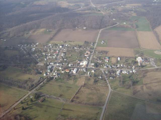
Photo: Nyttend, public domain · Wikimedia Commons
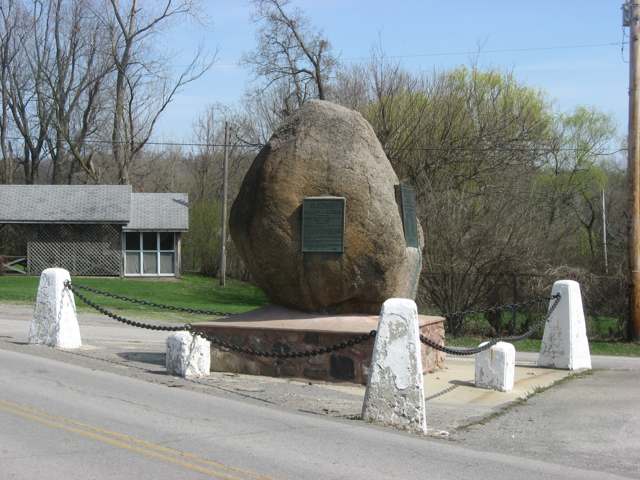
Photo: Nyttend, public domain · Wikimedia Commons
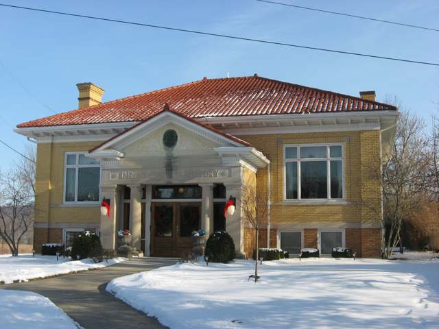
Photo: Nyttend, public domain · Wikimedia Commons
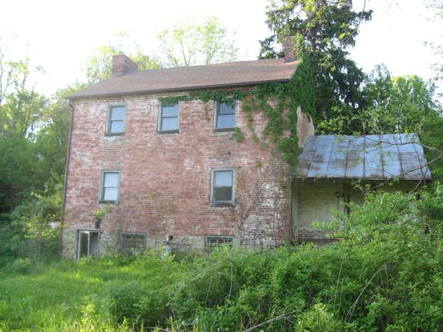
Photo: Nyttend, public domain · Wikimedia Commons
Local history sources: en.wikipedia.org · loganhistory.org · loganhistory.org · en.wikipedia.org · en.wikipedia.org · en.wikipedia.org · spectrumnews1.com · commons.wikimedia.org · commons.wikimedia.org · commons.wikimedia.org · commons.wikimedia.org · commons.wikimedia.org
Water
Mostly private wells The water here
- Mountainview Mobile Village100% of residentsGroundwater wells (2 wells)
Hospitals, fire stations and more
Inside Zanesfield's boundary: 1 fire or EMS station and 1 library. Press a pin or a name for its whole record and its source.
Fire and EMS stations (1)
-
Tri - Valley Fire District and Emergency Medical ServicesZanesfield
- Address
- 2568 Sandusky Street, Zanesfield, OH 43360
- Coordinates
- 40.34099, -83.67697
USGS National Map structures (source) ↗ Street map and directions ↗
Source: USGS National Map structures (most Ohio records last updated 2019 to 2022), checked against the Columbus and Cleveland station lists. The department that answers a call is set by jurisdiction and mutual aid, not by distance.
Public libraries (1)
-
Dr. Earl S. Sloan LibraryCentral library · Zanesfield
- Address
- 2817 Sandusky St., Zanesfield, OH 43360
- What it is
- Central library
- Library system
- Dr. Earl S. Sloan Library
- Open
- 1,380 hours a year, 46 weeks
- Building
- 3,984 sq ft
- System's visits, FY2024
- 2,756
- System's loans, FY2024
- 2,191
- People the system serves
- 194
- Phone
- (937) 210-5449
IMLS Public Libraries Survey (source) ↗ Street map and directions ↗
Source: IMLS Public Libraries Survey FY2024 (outlets and their systems). Any Ohio resident can get a free card at any Ohio public library.
Its ZIP codes
Each ZIP code that touches Zanesfield, with the share of its residents who live here and the same headline figures as the ZIP page.
| ZIP | Share | Water | Radon | Home value | Schools | Flood |
|---|---|---|---|---|---|---|
| 43360 Jefferson Township and Zanesfield | 12% | Mostly private wells | 13.2 pCi/L average radon | Median year built 1988 | Benjamin Logan Local · 4 stars overall | 3.1% of residents in the 1% floodplain |
Local government
Who holds office in Zanesfield, how its elections and ballot issues came out, and the state auditor's record.
Money issues on the ballot since 2020: 1 of 1 passed.
Ballot issues
| Date | Issue | For | Against | Result |
|---|---|---|---|---|
| 2022-11-08 | Issue: Village of Zanesfield Proposed Ordinance (Electric Aggregation) | 71 | 10 | Passed (87.65% for) |
| 2020-11-03 | Issue: Village of Zanesfield Current Expense Renewal Levy | 99 | 20 | Passed (83.19% for) |
Elections for office
| Date | Office | Candidates and votes |
|---|---|---|
| 2023-11-07 | Member of Council (unofficial count) | Mark R. Berkfield 55, 50.46%; Glenna M. Theis 54, 49.54% |
| 2021-11-02 | Member of Council | R. Wayne Downing 34, 51.52%; Jason Rose 32, 48.48% |
Winners in bold. Results from the county board of elections' official canvass unless marked.
Auditor of State record
- No fiscal caution, watch or emergency on the Auditor of State's lists.
- Basic Audit, 2024 to 2025, released 2026-04-14
- Basic Audit, 2022 to 2023, released 2024-09-10
The county
Logan County: 14 ZIP codes, 33 cities, villages and townships, 49,613 people.
Nearby places
Rain and snow
How much has actually fallen on Zanesfield, day by day, from 1893 to now. Daily totals, not averages.
- rain, last 30 days
- 1.14 in
- 2026-09-30 to 2026-10-29
- rain so far in 2026
- 48.3 in
- 12.3 in above normal for the date
- snow so far in 2026
- 18.9 in
- a normal year brings 19.4 in
- a normal year
- 42.3 in
- average of 30 years, 1991-2020
| Month | Rain (in) | Snow (in) | Days counted |
|---|---|---|---|
| October 2026 | 1.14 | — | 29 |
| September 2026 | 7.69 | — | 30 |
| August 2026 | 10.47 | — | 31 |
| July 2026 | 4.41 | — | 31 |
| June 2026 | 3.71 | — | 30 |
| May 2026 | 8.79 | — | 31 |
| April 2026 | 4.12 | — | 30 |
| March 2026 | 5.11 | 0.9 | 31 |
| February 2026 | 1.08 | 5.0 | 28 |
| January 2026 | 1.74 | 12.9 | 31 |
| December 2025 | 1.91 | 10.6 | 31 |
| November 2025 | 1.88 | 2.5 | 30 |
| Wettest year | 2011 — 61.1 in |
|---|---|
| Driest year | 1901 — 22.2 in |
| Snowiest year | 1914 — 66.3 in |
| Wettest day on record | 25 March 1913 — 5.31 in |
| Heaviest snowfall in a day | 23 December 2004 — 15.98 in |
| Deepest snow on the ground | 12 January 1996 — 18.24 in |
Estimated, not measured. No rain gauge has ever stood inside Zanesfield, so every figure here is worked out from the gauges around it - the nearest ones weighted most. Treat them as close estimates rather than readings.
48,745 days of records, 1893-01-01 to 2026-10-29. Source: NOAA NCEI GHCN-Daily, 3,240 gauges in and around Ohio. A day is "gauged" when a gauge standing inside the boundary reported it, and the value is the mean of those gauges. Otherwise it is interpolated by inverse distance from every gauge reporting within 50 miles. Nothing is carried forward, back-filled or smoothed. Against NOAA nClimDiv county monthly precipitation over 136,848 complete county-months (checked 2026-10-31): correlation 0.9515, median absolute difference 0.217 in a month. Built 2026-10-31 from the Cracked Buckeye precipitation archive. Snow is the softer number — snowfall is measured by hand with a ruler, no agency publishes a gridded county snowfall series, and blowing snow defeats every observer.
Environmental permits and filings
What Ohio EPA has on file for Zanesfield: permits, inspections, violations, cleanups and the state loans behind sewer and water work. Every line links to the agency's own document.
- facilities and sites on file
- 1
- those placed on the map inside Zanesfield
| Program | Facilities and sites |
|---|---|
| Public drinking water | 1 |
| Date | Facility or site | What |
|---|---|---|
| FIREHOUSE PIZZA PWS | Public drinking water compliance letter | |
| FIREHOUSE PIZZA PWS | Public drinking water compliance letter | |
| FIREHOUSE PIZZA PWS | Public drinking water permit | |
| FIREHOUSE PIZZA PWS | Public drinking water inspection | |
| FIREHOUSE PIZZA PWS | Public drinking water inspection | |
| FIREHOUSE PIZZA PWS | Public drinking water inspection | |
| FIREHOUSE PIZZA PWS | Public drinking water violation resolved | |
| FIREHOUSE PIZZA PWS | Public drinking water inspection | |
| FIREHOUSE PIZZA PWS | Public drinking water notice of violation | |
| FIREHOUSE PIZZA PWS | Public drinking water inspection | |
| FIREHOUSE PIZZA PWS | Public drinking water notice of violation | |
| FIREHOUSE PIZZA PWS | Public drinking water report |
Source: Ohio EPA eDocument portal (edocpub.epa.ohio.gov), indexed 2026-10-14. Facilities are placed on the map from Ohio EPA's own map layers, EPA's Facility Registry, coordinates written in the filings, or a geocoded street address. A permit filed under a private person's name (most are household septic systems) is counted but never named, placed or linked; licenses for individual workers and open-burning notices are left out entirely.
Quick answers
What county is Zanesfield, Ohio in?
Zanesfield is a village in Logan County, Ohio, with 194 residents.
When was Zanesfield, Ohio founded?
Zanesfield was settled c. 1776-1779 (Zane's Town); laid out 1819; incorporated 1819. Founders on record: Ebenezer Zane and Alexander Long. Source
How did Zanesfield, Ohio get its name?
The village is named for Isaac Zane (1753-1816), youngest brother of Ebenezer Zane the elder, founder of Zane's Trace and namesake of Zanesville. Source
What ZIP code is Zanesfield, Ohio?
Most of Zanesfield is in ZIP code 43360.
Where does Zanesfield, Ohio get its water?
The main water source for Zanesfield (Mountainview Mobile Village): Mostly private wells.
Cite this page
Cite this page as:
Cracked Buckeye, "Zanesfield, Logan County", https://crackedbuckeye.com/place/zanesfield/, built 2026-10-31, accessed [date].
How to cite · Report a correction · Built 2026-10-31
