Local events in Valley Hi
Nothing is posted for Valley Hi itself yet; here is what is on within 10 miles. All local events in Valley Hi
Know a calendar we should watch? Send the link
Checked October 20; the events page is refreshed daily.
How Valley Hi began
Valley Hi is a small village straddling Jefferson and Monroe townships, built on hillside terrain unusually steep for western Ohio, a few miles south of Zanesfield. It grew up around a ski resort: farmer-turned-developer John Shoots bought 307 acres of hillside in 1958, opened Valley High Ski Area in December 1962, and the surrounding settlement incorporated as its own village in 1968 with twenty-five residents. The resort, renamed Mad River Mountain in 1975 and now owned by Vail Resorts, has grown into the largest ski area in Ohio; the village itself grew alongside it, reaching 228 residents at the 2020 census.
Incorporated 1968, by residents of the settlement that had grown up around the Valley High ski resort.
Where the name comes from
The village takes its name from the Valley High ski resort around which it grew, itself named for its hillside, high-valley setting on steep terrain unusual for flat western Ohio; the resort operated as 'Valley High' from its 1962 opening until it was renamed Mad River Mountain in 1975.
Before the town
No source consulted names a Native American village, trail, mound or earthwork specifically within the land that became Valley Hi; the village did not exist as a settlement before the 20th century, and its ground was part of the open farmland and hills of Jefferson and Monroe townships. It lies a few miles from Zanesfield, itself built on the site of the Wyandot village Zane's Town and the Shawnee capital Wapatomica, and Valley Hi's southern edge reaches into Monroe Township, where the Shawnee town of Mackachack once stood. The steep, hilly terrain that made this spot suitable for a ski resort in the 20th century was the same terrain that shaped Wyandot and Shawnee travel and settlement patterns in the 1700s, favoring the flatter valley bottoms nearby over the ridge itself, though no source consulted states this directly for this specific tract.
Timeline
- — John Shoots purchased 307 acres of hillside farmland on County Road 5, south of Zanesfield, the tract that became the ski resort and later the village.
- — Skier Fred McPeck suggested to Shoots that the steep hillside be developed into a ski area.
- — Ohio Resorts, Inc., doing business as Valley High, was formally incorporated as a company.
- — Valley High Ski Area opened, with over 1,000 people attending a ribbon-cutting ceremony that included Governor James Rhodes and State Representative Roger Cloud.
- — The village of Valley Hi incorporated with twenty-five residents; its first official act as a village was to approve the sale of liquor within its boundaries.
- — John Shoots and fellow investors sold their stock in the resort to Charles P. Conrad, who renamed it Mad River Mountain.
- — The Martin Marmon House, a Quaker house built around 1820 a few miles away in Jefferson Township near Zanesfield, was listed on the National Register of Historic Places; it is the NRHP listing that shares Valley Hi's ZIP code but stands outside the village itself.
Stories
A ski hill built where western Ohio has almost no hills
Western Ohio is famously flat, which is what makes the terrain around Valley Hi unusual: a stretch of unusually steep, ridged ground a few miles south of Zanesfield. In 1958 John Shoots bought 307 acres of that hillside as farmland on County Road 5. The idea to turn it into a ski resort came from Fred McPeck, an avid skier, who talked Shoots into the venture in the spring of 1959. After incorporating as Ohio Resorts, Inc. in September 1961 and grading slopes over the following year, the resort opened as Valley High Ski Area on December 15, 1962, drawing more than a thousand people to its ribbon-cutting despite a snowstorm just days before; Governor James Rhodes himself took part in the ceremony. The settlement that grew up to serve the resort's staff and visitors became its own village in 1968, population twenty-five, whose very first act as an incorporated village was to legalize liquor sales within its borders. The resort changed hands and names in 1975, becoming Mad River Mountain, and has since grown under a series of owners — most recently Vail Resorts — into the largest ski area in Ohio, expanding from three original trails to sixteen.
Photographs
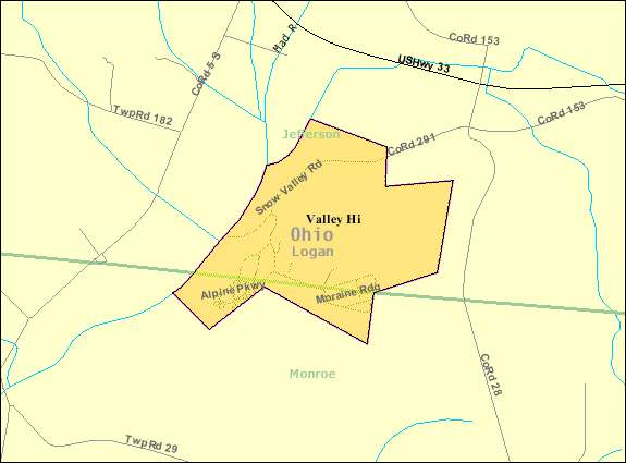
Photo: United States Census Bureau, public domain · Wikimedia Commons
Local history sources: peakofohio.com · en.wikipedia.org · en.wikipedia.org · en.wikipedia.org · en.wikipedia.org · commons.wikimedia.org
Water
Mostly private wells The water here
- Mountainview Mobile Village100% of residentsGroundwater wells (2 wells)
Its ZIP codes
Each ZIP code that touches Valley Hi, with the share of its residents who live here and the same headline figures as the ZIP page.
| ZIP | Share | Water | Radon | Home value | Schools | Flood |
|---|---|---|---|---|---|---|
| 43360 Jefferson Township and Zanesfield | 14% | Mostly private wells | 13.2 pCi/L average radon | Median year built 1988 | Benjamin Logan Local · 4 stars overall | 3.1% of residents in the 1% floodplain |
Local government
Who holds office in Valley Hi, how its elections and ballot issues came out, and the state auditor's record.
Auditor of State record
- No fiscal caution, watch or emergency on the Auditor of State's lists.
- Basic Audit, 2024 to 2025, released 2026-05-26
- Basic Audit, 2022 to 2023, released 2024-09-26
The county
Logan County: 14 ZIP codes, 33 cities, villages and townships, 49,613 people.
Nearby places
Rain and snow
How much has actually fallen on Valley Hi, day by day, from 1893 to now. Daily totals, not averages.
- rain, last 30 days
- 1.17 in
- 2026-09-30 to 2026-10-29
- rain so far in 2026
- 48.1 in
- 12.2 in above normal for the date
- snow so far in 2026
- 18.8 in
- a normal year brings 19.1 in
- a normal year
- 42.2 in
- average of 30 years, 1991-2020
| Month | Rain (in) | Snow (in) | Days counted |
|---|---|---|---|
| October 2026 | 1.17 | — | 29 |
| September 2026 | 7.74 | — | 30 |
| August 2026 | 10.14 | — | 31 |
| July 2026 | 4.59 | — | 31 |
| June 2026 | 3.71 | — | 30 |
| May 2026 | 8.79 | — | 31 |
| April 2026 | 3.92 | — | 30 |
| March 2026 | 5.20 | 1.0 | 31 |
| February 2026 | 1.13 | 4.9 | 28 |
| January 2026 | 1.73 | 13.0 | 31 |
| December 2025 | 1.90 | 10.6 | 31 |
| November 2025 | 1.90 | 2.4 | 30 |
| Wettest year | 2011 — 60.7 in |
|---|---|
| Driest year | 1901 — 22.4 in |
| Snowiest year | 1914 — 65.6 in |
| Wettest day on record | 25 March 1913 — 5.22 in |
| Heaviest snowfall in a day | 23 December 2004 — 15.98 in |
| Deepest snow on the ground | 12 January 1996 — 18.15 in |
Estimated, not measured. No rain gauge has ever stood inside Valley Hi, so every figure here is worked out from the gauges around it - the nearest ones weighted most. Treat them as close estimates rather than readings.
48,724 days of records, 1893-01-01 to 2026-10-29. Source: NOAA NCEI GHCN-Daily, 3,240 gauges in and around Ohio. A day is "gauged" when a gauge standing inside the boundary reported it, and the value is the mean of those gauges. Otherwise it is interpolated by inverse distance from every gauge reporting within 50 miles. Nothing is carried forward, back-filled or smoothed. Against NOAA nClimDiv county monthly precipitation over 136,848 complete county-months (checked 2026-10-31): correlation 0.9515, median absolute difference 0.217 in a month. Built 2026-10-31 from the Cracked Buckeye precipitation archive. Snow is the softer number — snowfall is measured by hand with a ruler, no agency publishes a gridded county snowfall series, and blowing snow defeats every observer.
Environmental permits and filings
What Ohio EPA has on file for Valley Hi: permits, inspections, violations, cleanups and the state loans behind sewer and water work. Every line links to the agency's own document.
- facilities and sites on file
- 1
- those placed on the map inside Valley Hi
| Program | Facilities and sites |
|---|---|
| Public drinking water | 1 |
| Date | Facility or site | What |
|---|---|---|
| MOUNTAIN TOP CAMPGROUND PWS | Public drinking water compliance letter | |
| MOUNTAIN TOP CAMPGROUND PWS | Public drinking water compliance letter | |
| MOUNTAIN TOP CAMPGROUND PWS | Public drinking water permit | |
| MOUNTAIN TOP CAMPGROUND PWS | Public drinking water inspection | |
| MOUNTAIN TOP CAMPGROUND PWS | Public drinking water inspection | |
| MOUNTAIN TOP CAMPGROUND PWS | Public drinking water inspection | |
| MOUNTAIN TOP CAMPGROUND | Public drinking water notice of violation | |
| MOUNTAIN TOP CAMPGROUND | Public drinking water inspection | |
| MOUNTAIN TOP CAMPGROUND | Public drinking water notice of violation | |
| MOUNTAIN TOP CAMPGROUND | Public drinking water inspection |
Source: Ohio EPA eDocument portal (edocpub.epa.ohio.gov), indexed 2026-10-14. Facilities are placed on the map from Ohio EPA's own map layers, EPA's Facility Registry, coordinates written in the filings, or a geocoded street address. A permit filed under a private person's name (most are household septic systems) is counted but never named, placed or linked; licenses for individual workers and open-burning notices are left out entirely.
Quick answers
What county is Valley Hi, Ohio in?
Valley Hi is a village in Logan County, Ohio, with 228 residents.
When was Valley Hi, Ohio founded?
Valley Hi was incorporated 1968. Founders on record: residents of the settlement that had grown up around the Valley High ski resort. Source
How did Valley Hi, Ohio get its name?
The village takes its name from the Valley High ski resort around which it grew, itself named for its hillside, high-valley setting on steep terrain unusual for flat western Ohio; the resort operated as 'Valley High' from its 1962 opening until it was renamed Mad River Mountain in 1975. Source
What ZIP code is Valley Hi, Ohio?
Most of Valley Hi is in ZIP code 43360.
Where does Valley Hi, Ohio get its water?
The main water source for Valley Hi (Mountainview Mobile Village): Mostly private wells.
Cite this page
Cite this page as:
Cracked Buckeye, "Valley Hi, Logan County", https://crackedbuckeye.com/place/valley-hi/, built 2026-10-31, accessed [date].
How to cite · Report a correction · Built 2026-10-31
