Local events in West Liberty
West Liberty itself has 1 event posted in the next 90 days; the others here are within 20 miles. All local events in West Liberty
Checked October 20; the events page is refreshed daily.
Deep dives about West Liberty
Long reads built from maps, newspapers and public records. All deep dives
How West Liberty began
West Liberty was laid out in 1817 around a gristmill built on the Mad River in 1816 and was incorporated in 1834. It stands about a mile from the site of Mackachack (also spelled Mac-a-cheek), one of a cluster of Shawnee towns along the Mad River destroyed in General Benjamin Logan's 1786 raid, and near Wapatomica, the Shawnee nation's political capital in the same period; frontiersman Simon Kenton was forced to run the gauntlet at both towns as a captive in 1778. In the 1860s and 1870s, brothers Abram and Donn Piatt, sons of an early Logan County judge, built two Gothic-style family estates just outside the village and named them Mac-A-Cheek and Mac-O-Chee for the old Shawnee towns; both are on the National Register of Historic Places and Mac-A-Cheek remains open as a house museum. A major fire destroyed much of the village's downtown on May 13, 1880, an event still marked locally by an annual fire sale.
Settled 1816, platted 1817, incorporated 1834, by settlers around a Mad River gristmill built in 1816.
Where the name comes from
No source consulted gives a documented origin for the name 'West Liberty' itself; it is a common American place name of the era (paired here with Liberty Township, in which the village partly sits) and we do not assert an origin beyond that. The GNIS historical name 'Mackachack' attached to this ZIP reflects the nearby Shawnee town, and 'Old Pimtown' is a locally used name for a nearby place (a road called Pimtown Road runs through the area) whose own origin could not be verified in the sources checked.
Before the town
West Liberty sits at the edge of what local historians call the Mac-a-cheek towns: a cluster of roughly ten Shawnee villages that occupied the Mad River valley in Logan County from the 1760s/1770s until 1786, home at various times to Shawnee leaders Moluntha, Black Hoof, and Blue Jacket. Mackachack (Mac-a-cheek), about one mile east of present West Liberty, and Wapatomica, near present Zanesfield and for a time the Shawnee nation's political capital, were among the most important. In September 1778, Kentucky frontiersman Simon Kenton, captured on a scouting raid near Chillicothe, was marched among these towns as a prisoner marked for execution and was forced to run gauntlets -- lines of villagers who beat captives with sticks and clubs -- at both Mackachack and Wapatomica; he was one of the few captives to survive nine such gauntlets, and was eventually saved from execution through the intercession of Simon Girty and adopted by the Shawnee before being sold to the British as a prisoner of war and taken to Detroit, from where he escaped within a few months. In the fall of 1786, Kentucky militia under General Benjamin Logan burned Mackachack, Wapatomica, and the other towns of the cluster in retaliation for continued raids on Kentucky settlements; Shawnee chief Moluntha was murdered by militia colonel Hugh McGary during the raid despite having surrendered peacefully. The Shawnee who survived the 1786 destruction largely regrouped further north and west, and the region passed out of Shawnee control after the 1795 Treaty of Greenville. A separate Wyandot presence is recorded a few miles east at Zanesfield in Jefferson Township, where trader Isaac Zane, adopted by the Wyandot as a boy and married to Myeerah, daughter of Wyandot chief Tarhe, settled with his family; see T38682-LOG for that history.
Nations recorded here: Shawnee, Wyandot.
- Mackachack (Mac-a-cheek) (village) — about one mile east of West Liberty, 1760s/1770s-1786 (hmdb.org)
- Wapatomica (village) — near Zanesfield, Logan County, to 1786 (en.wikipedia.org)
Timeline
- — A gristmill was built on the Mad River at the site that became West Liberty.
- — West Liberty was laid out around the mill.
- — The village held five stores, two taverns, a tannery, a merchant mill, a saw mill, a carding machine, and about 20 houses.
- — West Liberty was formally incorporated.
- — Construction began on Mac-A-Cheek, the Piatt family's Gothic-style stone house outside West Liberty, named for the nearby Shawnee town; it was completed in 1871 for Abram S. Piatt.
- — Abram's brother Donn Piatt completed the neighboring house Mac-O-Chee, designed by architect John L. Smithmeyer, about three-quarters of a mile from Mac-A-Cheek.
- — A fire beginning in a stable on May 13 spread through downtown West Liberty and destroyed much of it; the village still commemorates the event with an annual fire sale.
- — Both Mac-A-Cheek and Mac-O-Chee were listed on the National Register of Historic Places, on May 3.
- — Mac-O-Chee was sold at auction in October to local buyers for $561,000; Mac-A-Cheek remains in Piatt family hands and open for tours.
Stories
Simon Kenton's gauntlets at Mackachack and Wapatomica
In September 1778, Simon Kenton, a young Kentucky scout, was captured by Shawnee warriors during a raid near Chillicothe. Because Kenton had killed and stolen horses from the Shawnee before, his captors judged him an enemy important enough to be taken to Wapatomica, then the political center of the Shawnee nation, to be tried and executed. On the way, the Shawnee paraded him through their towns along the Mad River, including Mackachack, and at each stop forced him to run the gauntlet -- two lines of villagers armed with sticks, clubs and fists, meant to batter a captive half to death before he reached the end. Kenton ran the gauntlet at Mackachack and again at Wapatomica, was condemned to be burned at the stake, and was spared only when the renegade frontiersman Simon Girty, an old acquaintance, recognized him and argued the Shawnee council into sparing his life. Kenton survived nine gauntlet runs in all before the Shawnee were persuaded to sell him to the British as a prisoner of war; he was taken to Detroit and escaped within a few months. The towns where this happened stood within what is now Logan County, and West Liberty grew up a few decades later almost on top of the Mackachack townsite.
Judge Piatt's sons built castles named for the towns their family displaced
In the 1820s, Judge Benjamin M. Piatt and his wife Elizabeth Barnett Piatt moved from Cincinnati to the rolling farmland outside West Liberty, land that a generation earlier had been part of the Shawnee towns burned in 1786. Their sons Abram and Donn, both Civil War veterans, built substantial stone houses on the family property using stone, timber and brick quarried and milled on the land itself -- only the window glass and slate roofing were bought elsewhere. Abram named his 1871 house Mac-A-Cheek and Donn named his 1879 house, three-quarters of a mile away, Mac-O-Chee: both names taken directly from Mackachack, the Shawnee town that had stood nearby before Logan's raid. The houses, with elaborate painted ceilings, carved woodwork and even indoor plumbing, became family museums early in the twentieth century; Mac-A-Cheek is still open to the public today, while Mac-O-Chee was sold out of the family in 2019.
Photographs
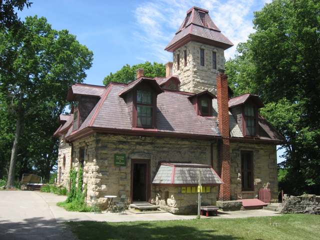
Photo: Nyttend, public domain · Wikimedia Commons
Local history sources: mywestliberty.com · en.wikipedia.org · loganhistory.org · hmdb.org · commons.wikimedia.org · en.wikipedia.org · loganhistory.org
Water
Mostly private wells The water here
- West Liberty Village100% of residentsGroundwater wells (2 wells)
Hospitals, fire stations and more
Inside West Liberty's boundary: 1 nursing home, 1 fire or EMS station, 1 library, 1 museum, 1 police station and 1 Toxics Release Inventory facility. Press a pin or a name for its whole record and its source.
Nursing homes (1)
-
Green Hills Center3 of 5 stars · West Liberty
- Address
- 6557 Us 68 South, West Liberty, OH 43357
- Certified beds
- 74
- Residents on an average day
- 73
- Medicare overall rating
- 3 of 5 stars
- Health inspections
- 3 of 5 stars
- Staffing
- 2 of 5 stars
- Quality measures
- 4 of 5 stars
- Penalties since 2023
- 1 fine totalling $16,801 (latest 2024-01-22)
- Ownership
- Non profit - Other
- Chain
- OTTERBEIN SENIORLIFE
- Continuing care retirement community
- Yes
- Takes
- Medicare and Medicaid
- Phone
- (937) 465-5065
- Medicare ID
- 365362
Medicare Care Compare ↗ CMS nursing home data (source) ↗ Street map and directions ↗
Source: CMS Care Compare nursing home provider and penalties files; Medicare star ratings run 1 to 5.
Fire and EMS stations (1)
-
West Liberty Fire DepartmentWest Liberty
- Address
- 201 North Detroit Street, West Liberty, OH 43357
- Coordinates
- 40.25354, -83.75546
USGS National Map structures (source) ↗ Street map and directions ↗
Source: USGS National Map structures (most Ohio records last updated 2019 to 2022), checked against the Columbus and Cleveland station lists. The department that answers a call is set by jurisdiction and mutual aid, not by distance.
Public libraries (1)
-
West Liberty Branch LibraryBranch · West Liberty
- Address
- 117 N Detroit St, West Liberty, OH 43357
- What it is
- Branch
- Library system
- Logan County District Library
- Open
- 1,456 hours a year, 52 weeks
- Building
- 1,050 sq ft
- System's visits, FY2024
- 64,844
- System's loans, FY2024
- 287,627
- People the system serves
- 31,399
- Phone
- (937) 465-3656
IMLS Public Libraries Survey (source) ↗ Street map and directions ↗
Source: IMLS Public Libraries Survey FY2024 (outlets and their systems). Any Ohio resident can get a free card at any Ohio public library.
Museums, historical societies, gardens and zoos (1)
-
West Liberty Historical SocietyHistorical society · West Liberty
- What it is
- Historical society
- City
- West Liberty
- Coordinates
- 40.26631, -83.75874
Search Wikipedia ↗ IMLS Museum Data Files (source) ↗ Street map and directions ↗
The museum list is IMLS's 2018 file; a museum may have closed or moved since.
Source: IMLS Museum Data Files, 2018.
Police stations (1)
-
West Liberty Police DepartmentWest Liberty
- Address
- 201 North Detroit Street, West Liberty, OH 43357
- Coordinates
- 40.25355, -83.75575
USGS National Map structures (source) ↗ Street map and directions ↗
Source: USGS National Map structures, police stations, corrected and completed by hand (September 2026). The department that answers a call is set by jurisdiction, not by distance.
Facilities reporting toxic releases (1)
-
General Casting Co West Liberty DivToxics Release Inventory · West Liberty
- Address
- 600 N. Detroit St., West Liberty, OH 43357
- County
- Logan County
- Status
- Reports to the Toxics Release Inventory (active)
- EPA program ID
- 43357HBRTC600ND
- EPA registry ID
- 110000383095
EPA facility record ↗ EPA Facility Registry Service (source) ↗ Street map and directions ↗
Source: EPA Facility Registry Service, Toxics Release Inventory reporters. Reporting a release is required of large users of listed chemicals; it is not by itself a violation.
Its ZIP codes
Each ZIP code that touches West Liberty, with the share of its residents who live here and the same headline figures as the ZIP page.
| ZIP | Share | Water | Radon | Home value | Schools | Flood |
|---|---|---|---|---|---|---|
| 43357 West Liberty | 37% | Mostly private wells | 10.1 pCi/L average radon | Median year built 1964 | West Liberty-Salem Local · 4.5 stars overall | 11% of residents in the 1% floodplain |
Local government
Who holds office in West Liberty, how its elections and ballot issues came out, and the state auditor's record.
Money issues on the ballot since 2019: 3 of 4 passed; of those asking for new or higher taxes, 0 of 1.
Ballot issues
| Date | Issue | For | Against | Result |
|---|---|---|---|---|
| 2023-11-07 | Issue: West Liberty Current Expense Renewal | 379 | 325 | Passed (53.84% for), unofficial |
| 2022-11-08 | Issue: Village of West Liberty Proposed Ordinance (Electric Aggregation) | 471 | 185 | Passed (71.8% for) |
| 2022-11-08 | Issue: Village of West Liberty Proposed Ordinance (Natural Gas Aggregation) | 476 | 176 | Passed (73.01% for) |
| 2021-11-02 | Issue: West Liberty Current Expense (Renewal) Village Of West Liberty | 274 | 159 | Passed (63.28% for) |
| 2020-03-17 | Issue: West Liberty Village Tax Levy (Additional) | 181 | 218 | Failed (45.36% for) |
| 2019-11-05 | Issue: West Liberty Village Tax Levy (Renewal) | 282 | 173 | Passed (61.98% for) |
Elections for office
| Date | Office | Candidates and votes |
|---|---|---|
| 2023-11-07 | Member of Council (unofficial count) | Shannon L. Maier 551, 100.0% |
| 2023-11-07 | Member of Board of Public Affairs (unofficial count) | Write-In: Stacy Merriman 15, 38.46% |
| 2023-11-07 | Mayor (unofficial count) | Bradley A. Hudson 404, 60.12%; Jill C. McKelvey 268, 39.88% |
| 2021-11-02 | Member of Council | Jayne Griffith 303, 22.63%; Jim Hoffman 269, 20.09%; Hope L. Justice 82, 6.12%; Sam Park 172, 12.85%; Kenneth Ruetsch 57, 4.26%; Trent Spriggs 205, 15.31%; A. Jeanette Zerkle 251, 18.75% |
| 2021-11-02 | Mayor | Jill C. McKelvey 243, 100.0% |
| 2019-11-05 | Mayor | Write-In: Chance Carroll 194, 76.08%; Write-In: Jill McKelvey 25, 9.8% |
| 2019-11-05 | Clerk-Treasurer | Cindee M. Boyd 393, 100.0% |
Winners in bold. Results from the county board of elections' official canvass unless marked.
The county
Logan County: 14 ZIP codes, 33 cities, villages and townships, 49,613 people.
Nearby places
Rain and snow
How much has actually fallen on West Liberty, day by day, from 1893 to now. Daily totals, not averages.
- rain, last 30 days
- 1.33 in
- 2026-09-30 to 2026-10-29
- rain so far in 2026
- 49.0 in
- 12.8 in above normal for the date
- snow so far in 2026
- 21.0 in
- a normal year brings 16.0 in
- a normal year
- 42.7 in
- average of 30 years, 1991-2020
| Month | Rain (in) | Snow (in) | Days counted |
|---|---|---|---|
| October 2026 | 1.33 | — | 29 |
| September 2026 | 8.71 | — | 30 |
| August 2026 | 8.65 | — | 31 |
| July 2026 | 5.45 | — | 31 |
| June 2026 | 4.12 | — | 30 |
| May 2026 | 9.55 | — | 31 |
| April 2026 | 3.03 | — | 30 |
| March 2026 | 5.16 | 1.5 | 31 |
| February 2026 | 1.38 | 5.5 | 28 |
| January 2026 | 1.64 | 13.9 | 31 |
| December 2025 | 1.69 | 10.4 | 31 |
| November 2025 | 1.91 | 2.5 | 30 |
| Wettest year | 2011 — 60.4 in |
|---|---|
| Driest year | 1934 — 23.4 in |
| Snowiest year | 1914 — 63.7 in |
| Wettest day on record | 25 March 1913 — 4.77 in |
| Heaviest snowfall in a day | 26 November 1950 — 13.96 in |
| Deepest snow on the ground | 12 January 1996 — 18.22 in |
Estimated, not measured. No rain gauge has ever stood inside West Liberty, so every figure here is worked out from the gauges around it - the nearest ones weighted most. Treat them as close estimates rather than readings.
48,667 days of records, 1893-01-01 to 2026-10-29. Source: NOAA NCEI GHCN-Daily, 3,240 gauges in and around Ohio. A day is "gauged" when a gauge standing inside the boundary reported it, and the value is the mean of those gauges. Otherwise it is interpolated by inverse distance from every gauge reporting within 50 miles. Nothing is carried forward, back-filled or smoothed. Against NOAA nClimDiv county monthly precipitation over 136,848 complete county-months (checked 2026-10-31): correlation 0.9515, median absolute difference 0.217 in a month. Built 2026-10-31 from the Cracked Buckeye precipitation archive. Snow is the softer number — snowfall is measured by hand with a ruler, no agency publishes a gridded county snowfall series, and blowing snow defeats every observer.
Environmental permits and filings
What Ohio EPA has on file for West Liberty: permits, inspections, violations, cleanups and the state loans behind sewer and water work. Every line links to the agency's own document.
- facilities and sites on file
- 3
- those placed on the map inside West Liberty
| Program | Facilities and sites |
|---|---|
| Hazardous waste | 1 |
| Sewer and water-line construction | 1 |
| State water loans | 1 |
| Date | Facility or site | What |
|---|---|---|
| WEST LIBERTY WTP | Sewer and water-line construction permit | |
| WEST LIBERTY WTP | Sewer and water-line construction permit | |
| WEST LIBERTY WTP | Sewer and water-line construction permit | |
| WEST LIBERTY VILLAGE PWS | State water loans | |
| WEST LIBERTY VILLAGE PWS | State water loans | |
| WEST LIBERTY VILLAGE PWS | State water loans | |
| WEST LIBERTY VILLAGE PWS | State water loans | |
| WEST LIBERTY VILLAGE PWS | State water loans |
Source: Ohio EPA eDocument portal (edocpub.epa.ohio.gov), indexed 2026-10-14. Facilities are placed on the map from Ohio EPA's own map layers, EPA's Facility Registry, coordinates written in the filings, or a geocoded street address. A permit filed under a private person's name (most are household septic systems) is counted but never named, placed or linked; licenses for individual workers and open-burning notices are left out entirely.
Quick answers
What county is West Liberty, Ohio in?
West Liberty is a village in Logan County, Ohio, with 1,770 residents.
When was West Liberty, Ohio founded?
West Liberty was settled 1816; laid out 1817; incorporated 1834. Founders on record: settlers around a Mad River gristmill built in 1816. Source
What ZIP code is West Liberty, Ohio?
Most of West Liberty is in ZIP code 43357.
Where does West Liberty, Ohio get its water?
The main water source for West Liberty (West Liberty Village): Mostly private wells.
Cite this page
Cite this page as:
Cracked Buckeye, "West Liberty, Logan County", https://crackedbuckeye.com/place/west-liberty/, built 2026-10-31, accessed [date].
How to cite · Report a correction · Built 2026-10-31
