Local events in Waynesville
Nothing is posted for Waynesville itself yet; here is what is on within 10 miles. All local events in Waynesville
Know a calendar we should watch? Send the link
Checked October 20; the events page is refreshed daily.
Lakes near Waynesville
The history under the water: the valley before, the dam, the stories. All Ohio lakes
Deep dives about Waynesville
Long reads built from maps, newspapers and public records. All deep dives
How Waynesville began
Waynesville was founded on March 8, 1797 by Samuel Heighway, an English engineer from Shropshire, who with Dr. Evan Banes bought 30,000 acres of the Symmes Purchase between the Little and Great Miami Rivers and laid the town out in 1802 as a formal English village, with parks and squares arranged around a central public square. It was named for General "Mad" Anthony Wayne, whose 1794-95 campaign and the resulting Treaty of Greenville had opened the land to settlement only two years before Heighway arrived. Quaker families from the Carolinas began arriving in 1799, giving Waynesville a lasting Quaker and antislavery character reflected in its Underground Railroad history. A 36-acre, roughly 100-building Main Street Historic District (added to the National Register in 2002) survives largely intact, and since the 1970s-80s the village has rebuilt its economy around antique shops in its historic buildings and the annual Ohio Sauerkraut Festival, drawing several hundred thousand visitors a year.
Settled 1797-03-08, platted 1802, by Samuel Heighway (with Dr. Evan Banes).
Where the name comes from
Named for General "Mad" Anthony Wayne, whose troops are said to have camped near the site and whose victory at Fallen Timbers and the subsequent Treaty of Greenville (1795) opened the Symmes Purchase lands to the settlers who founded the town two years later.
Before the town
No village-specific Native American site (a named town, mound, or documented encounter inside present Waynesville) turned up in the sources checked. What is documented is regional context: Waynesville sits in the Little Miami River valley, part of the hunting and travel territory of the Shawnee and Miami in the eighteenth century, and the land Samuel Heighway purchased and platted in 1797 had been ceded by the Wyandot, Shawnee, Delaware, Miami, Ottawa, Ojibwa, Potawatomi and other nations of the Northwest Indian Confederation to the United States by the Treaty of Greenville, signed August 3, 1795 - the treaty line runs well north of Warren County, so all of the Waynesville area was included in the cession. The Little Miami valley was long occupied before that: Fort Ancient, the largest prehistoric hilltop earthwork enclosure in the United States, stands on the Little Miami about seven miles southeast of Lebanon in Washington Township, Warren County - built by the Hopewell culture (roughly 200 BC-AD 400) on ground occupied for millennia before that, and later giving its name to the Fort Ancient culture (about AD 1000-1650) that succeeded the mound-building Hopewell in the region. Fort Ancient is a real place in Warren County but it is not in or adjacent to Waynesville village; it should not be described as a Waynesville site.
Nations recorded here: Shawnee, Miami, Wyandot, Lenape (Delaware), Hopewell culture, Fort Ancient culture.
- Fort Ancient (earthwork) — Washington Township, Warren County, on the Little Miami River, about 7 miles southeast of Lebanon (not in or adjoining Waynesville), Hopewell culture, c. 200 BC - AD 400, with later Fort Ancient culture reoccupation (ohiohistory.org)
Timeline
- — The Treaty of Greenville, ending the Northwest Indian War, cedes most of Ohio including the future site of Waynesville to the United States, clearing the way for the Symmes Purchase settlement two years later.
- — Samuel Heighway, an English engineer, and his settlement party arrive and found Waynesville on land bought from John Cleves Symmes, naming it for General "Mad" Anthony Wayne.
- — The first Quaker families, those of Abijah O'Neall and James Mills, arrive in Waynesville from the Bush River Monthly Meeting in South Carolina.
- — Heighway lays out the town plat in the style of an English village, with formal parks and squares arranged around a central public square.
- — A post office is established at Waynesville.
- — The Miami Monthly Meetinghouse is built at Waynesville; it is described locally as the oldest place of worship west of the Allegheny Mountains still in use.
- — The John Satterthwaite House, later listed on the National Register, is built at the southern end of Somerset Lane in Waynesville.
- — The Mahlon Bateman House, later called the most important Greek Revival building in the historic district, is built on South Main Street.
- — Waynesville builds its first fire station (the Engine House); a jail addition follows in 1886, and the combined building at 260 Chapman Street is later listed on the National Register as the Waynesville Engine House and Lockup.
- — Waynesville's retail merchants launch the first Ohio Sauerkraut Festival as an economic-development idea; about 1,500 people attend.
- — Waynesville becomes known as the "Antiques Capital of the Midwest" as antique dealers fill the village's historic houses and storefronts.
- — The Waynesville Main Street Historic District, roughly 36 acres and about 98 contributing buildings along five blocks of Main Street, is listed on the National Register of Historic Places.
Stories
An Englishman's paper capital
Samuel Heighway came from Shropshire, England, an engineer with grand ambitions, and in 1796 organized a settlement party in Philadelphia that traveled by flatboat down the Allegheny, the Monongahela and the Ohio to reach the Symmes Purchase. Landing in 1797, he and Dr. Evan Banes bought 30,000 acres between the Little and Great Miami Rivers, and Heighway platted his town in 1802 as if it were the capital of the Northwest Territory he believed it would become: formal parks and squares arranged around a central public square, with plans for a serpentine walk, groves of ornamental trees, fishponds and fountains, and a proposed "Government House." The capital never came - Chillicothe and later Columbus took that role - but the square names Heighway gave his English-style village still mark the corners of downtown Waynesville on signposts more than two centuries later, a design fossil of a dream that did not happen.
Quakers, safe houses, and the Little Miami
Only two years after Heighway's founding, the Quaker families of Abijah O'Neall and James Mills arrived from the Bush River Monthly Meeting in South Carolina, part of a wave of Friends who left the slaveholding South looking for free soil in the Northwest Territory. The Miami Monthly Meetinghouse, built in 1811, still stands as, by local reckoning, the oldest place of worship west of the Allegheny Mountains. That Quaker and abolitionist community turned its village into a documented stop on the Underground Railroad: local history and the Museum at the Friends Home describe a network of safe houses and tunnels connecting to the Little Miami River, along which escaping enslaved people could continue north, and the museum now runs a walking tour of more than a dozen sites tied to that history.
From farm town to antiques capital
For most of the twentieth century Waynesville was an ordinary small Warren County farm town of a few thousand people. What changed its fortune was not new construction but the opposite: because the village never tore down its nineteenth-century Main Street to build modern storefronts, its roughly 200 historic buildings survived intact, many of them former homes rather than purpose-built shops. Antique dealers began moving into those houses, and by the 1980s the village had branded itself the "Antiques Capital of the Midwest," with close to thirty shops now operating inside the squares Heighway laid out in 1802. In 1970 the village's retail merchants, looking for a way to draw visitors, started the Ohio Sauerkraut Festival on the second weekend of October; the first festival drew about 1,500 people, and the modern event, with German sundaes and sauerkraut-based dishes for sale up and down Main Street, now draws several hundred thousand visitors over a single weekend.
Photographs
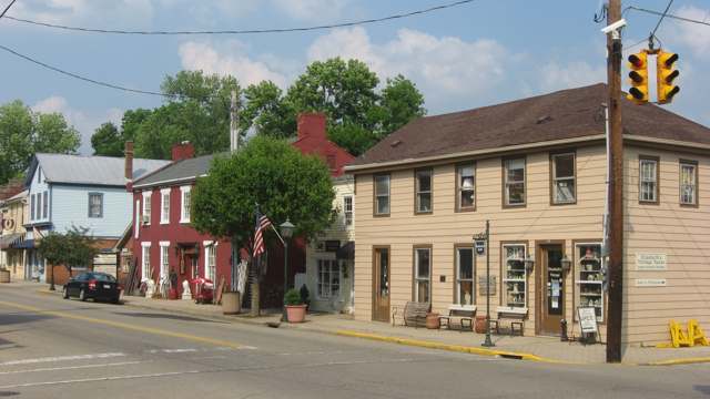
Photo: Nyttend, public domain · Wikimedia Commons
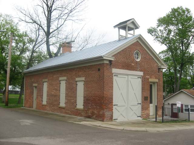
Photo: Nyttend, public domain · Wikimedia Commons
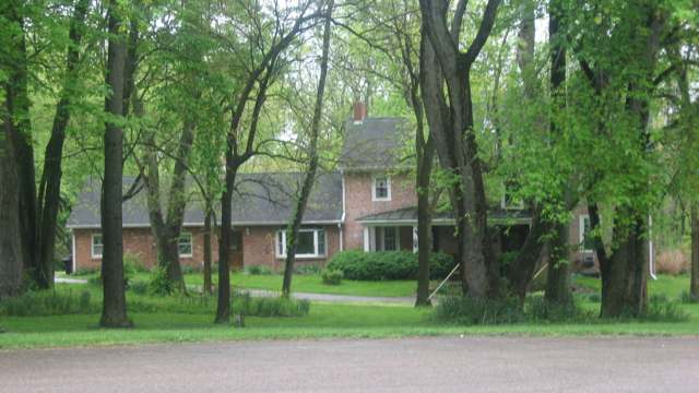
Photo: Nyttend, public domain · Wikimedia Commons
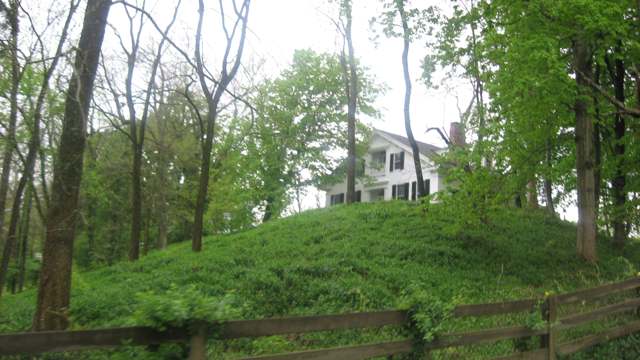
Photo: Nyttend, public domain · Wikimedia Commons
Local history sources: en.wikipedia.org · villageofwaynesville.org · waynesvilleshops.com · fernwehtun.com · en.wikipedia.org · en.wikipedia.org · commons.wikimedia.org · en.wikipedia.org · britannica.com · ohiohistory.org · littlemiamistatepark.org · commons.wikimedia.org · commons.wikimedia.org · commons.wikimedia.org · commons.wikimedia.org
Historic places
2 places in Waynesville on the National Register of Historic Places. Press a pin or a name for its whole record.
-
Satterthwaite, John, HouseBuilding · Waynesville · listed 1988
- Address
- 498 N. Third St.
- Where
- Waynesville, Warren County · ZIP 45068
- What it is
- Building
- Listed on the National Register
- 1988
- NRIS reference number
- 88000239
- Coordinates
- 39.53592, -84.07920
National Register file (NPS) ↗ Search Wikipedia ↗ Street map and directions ↗ On the Cracked Buckeye map
-
Waynesville Engine House and LockupBuilding · Waynesville · listed 1999
- Address
- 260 Chapman St.
- Where
- Waynesville, Warren County · ZIP 45068
- What it is
- Building
- Listed on the National Register
- 1999
- NRIS reference number
- 98001643
- Coordinates
- 39.53220, -84.08541
National Register file (NPS) ↗ Search Wikipedia ↗ Street map and directions ↗ On the Cracked Buckeye map
Source: National Park Service, National Register of Historic Places point file. The listing year is shown where NPS's certification date agrees with the listing's reference number. Listing recognizes significance; it does not restrict a private owner.
Water
Mostly private wells The water here
- Waynesville Village94% of residentsGroundwater wells (4 wells)
- Western Water Company3% of residentsLittle Miami River valley wells (51%) plus Cincinnati Ohio River water (49%)
- Greene County - southwest Reg Water2% of residentsGroundwater wells (2 wells)
Hospitals, fire stations and more
Inside Waynesville's boundary: 1 nursing home, 1 fire or EMS station, 3 public schools, 2 libraries, 1 museum, 1 police station and 2 spill cases. Press a pin or a name for its whole record and its source.
Nursing homes (1)
-
Ohio Living Quaker Heights4 of 5 stars · Waynesville
- Address
- 514 West High Street, Waynesville, OH 45068
- Certified beds
- 66
- Residents on an average day
- 58
- Medicare overall rating
- 4 of 5 stars
- Health inspections
- 3 of 5 stars
- Staffing
- 3 of 5 stars
- Quality measures
- 5 of 5 stars
- Penalties since 2023
- none
- Ownership
- Non profit - Corporation
- Chain
- OHIO LIVING COMMUNITIES
- Takes
- Medicare and Medicaid
- Phone
- (513) 897-6050
- Medicare ID
- 365974
Medicare Care Compare ↗ CMS nursing home data (source) ↗ Street map and directions ↗
Source: CMS Care Compare nursing home provider and penalties files; Medicare star ratings run 1 to 5.
Fire and EMS stations (1)
-
Wayne Township Fire Department and Emergency Medical Services Station 91Waynesville
- Address
- 165 Miami Street, Waynesville, OH 45068
- Coordinates
- 39.52932, -84.08644
USGS National Map structures (source) ↗ Street map and directions ↗
Source: USGS National Map structures (most Ohio records last updated 2019 to 2022), checked against the Columbus and Cleveland station lists. The department that answers a call is set by jurisdiction and mutual aid, not by distance.
Public schools (3)
-
Waynesville Elementary School5 of 5 stars · Waynesville
- Address
- 659 Dayton Rd, Waynesville, OH 45068
- School district
- Wayne Local School District
- Kind (NCES)
- Regular School
- Students, 2023-24
- 925
- Teachers (full-time equivalent)
- 38.5
- Report card, 2025-26
- 5 of 5 stars
- Performance index
- 95.9%
- Ohio building IRN
- 039925
- NCES school ID
- 390504603955
NCES school record ↗ Ohio School Report Card ↗ Street map and directions ↗
-
Waynesville High School5 of 5 stars · Waynesville
- Address
- 735 Dayton Rd, Waynesville, OH 45068
- School district
- Wayne Local School District
- Kind (NCES)
- Regular School
- Students, 2023-24
- 441
- Teachers (full-time equivalent)
- 27.32
- Report card, 2025-26
- 5 of 5 stars
- Performance index
- 92.2%
- Four-year graduation rate
- 98.6%
- Ohio building IRN
- 040055
- NCES school ID
- 390504603956
NCES school record ↗ Ohio School Report Card ↗ Street map and directions ↗
-
Waynesville Middle School4 of 5 stars · Waynesville
- Address
- 723 Dayton Rd, Waynesville, OH 45068
- School district
- Wayne Local School District
- Kind (NCES)
- Regular School
- Students, 2023-24
- 264
- Teachers (full-time equivalent)
- 15
- Report card, 2025-26
- 4 of 5 stars
- Performance index
- 89.6%
- Ohio building IRN
- 061614
- NCES school ID
- 390504604379
NCES school record ↗ Ohio School Report Card ↗ Street map and directions ↗
Source: NCES EDGE public school locations 2024-25 and Common Core of Data 2023-24 (type, students, teachers); Ohio School Report Cards 2025-26 (Department of Education and Workforce), matched by name within the district.
Public libraries (2)
-
Mary L. Cook Public LibraryCentral library · Waynesville
- Address
- 381 Old Stage Rd., Waynesville, OH 45068
- What it is
- Central library
- Library system
- Mary L. Cook Public Library
- Open
- 2,704 hours a year, 52 weeks
- Building
- 22,328 sq ft
- System's visits, FY2024
- 32,084
- System's loans, FY2024
- 248,068
- People the system serves
- 24,280
- Phone
- (513) 897-4826
IMLS Public Libraries Survey (source) ↗ Street map and directions ↗
-
Waynesville Elementary Media CenterBranch · Waynesville
- Address
- 659 Dayton Road, Waynesville, OH 45068
- What it is
- Branch
- Library system
- Mary L. Cook Public Library
- Open
- 1,710 hours a year, 38 weeks
- Building
- 2,974 sq ft
- System's visits, FY2024
- 32,084
- System's loans, FY2024
- 248,068
- People the system serves
- 24,280
- Phone
- (513) 897-2761
IMLS Public Libraries Survey (source) ↗ Street map and directions ↗
Source: IMLS Public Libraries Survey FY2024 (outlets and their systems). Any Ohio resident can get a free card at any Ohio public library.
Museums, historical societies, gardens and zoos (1)
-
Wombat ArtworksMuseum · Waynesville
- What it is
- Museum
- City
- Waynesville
- Coordinates
- 39.54043, -84.08932
Search Wikipedia ↗ IMLS Museum Data Files (source) ↗ Street map and directions ↗
The museum list is IMLS's 2018 file; a museum may have closed or moved since.
Source: IMLS Museum Data Files, 2018.
Police stations (1)
-
Waynesville Police DepartmentWaynesville
- Address
- 1400 Lytle Road, Waynesville, OH 45068
- Coordinates
- 39.54493, -84.09025
USGS National Map structures (source) ↗ Street map and directions ↗
Source: USGS National Map structures, police stations, corrected and completed by hand (September 2026). The department that answers a call is set by jurisdiction, not by distance.
Spills reported since 2021 (2)
-
Other / All Other / Trade Name / Mixture / Solution Etc2024-06-13 · Waynesville
- Reported
- 2024-06-13
- What spilled
- Other / All Other / Trade Name / Mixture / Solution Etc
- Where
- Waynesville, Warren County
- Ohio EPA district office
- SWDO
- Ohio EPA case number
- 2406EPA0000998
Ohio EPA spill reports (source) ↗ Street map and directions ↗
-
Fuel Diesel / Diesel Fuel (Vehicle On Or Off Road)2026-07-28 · Waynesville
- Reported
- 2026-07-28
- What spilled
- Fuel Diesel / Diesel Fuel (Vehicle On Or Off Road)
- Largest amount reported
- 50 gallons
- Where
- Waynesville, Warren County
- Ohio EPA district office
- SWDO
- Ohio EPA case number
- 2607EPA0001377
Ohio EPA spill reports (source) ↗ Street map and directions ↗
Source: Ohio EPA emergency response spill reports, 2021 to September 2026, one point per case where Ohio EPA placed it. A report is what the caller or responder recorded; amounts are often blank or estimated.
Its ZIP codes
Each ZIP code that touches Waynesville, with the share of its residents who live here and the same headline figures as the ZIP page.
| ZIP | Share | Water | Radon | Home value | Schools | Flood |
|---|---|---|---|---|---|---|
| 45068 Wayne Township and Waynesville | 22% | Mostly private wells | 4.7 pCi/L average radon | Appraisal records without year built | Wayne Local · 4.5 stars overall | 3.6% of residents in the 1% floodplain |
Local government
Who holds office in Waynesville, how its elections and ballot issues came out, and the state auditor's record.
Money issues on the ballot since 2017: 2 of 3 passed.
Ballot issues
| Date | Issue | For | Against | Result |
|---|---|---|---|---|
| 2018-05-08 | Issue 5: 5 Village of Waynesville Tax Levy Ren | 295 | 183 | Passed (61.72% for) |
| 2017-11-07 | Issue 14: 14 Waynesville Tax Levy Renewal | 456 | 345 | Passed (56.93% for) |
| 2017-11-07 | Issue 15: 15 Waynesville Tax Levy Ren & Increase | 361 | 427 | Failed (45.81% for) |
| 2016-11-08 | Issue 5: 5 Waynesville Charter Amendment | 867 | 461 | Passed (65.29% for) |
Elections for office
| Date | Office | Candidates and votes |
|---|---|---|
| 2017-11-07 | Member of Council | Earl J. Isaacs 428, 28.1%; Chris Colvin 399, 26.2%; Brian S. Blankenship 386, 25.34%; Kimberley Kaan 310, 20.35% |
| 2017-11-07 | Member of Council | Joette H. Dedden 417, 100.0% |
| 2015-11-03 | Member of Council | INVALID WRITE-INs 41, 73.21%; Claude Powers Jr. 15, 26.79% |
| 2015-11-03 | Mayor | David A. Stubbs 744, 100.0% |
Winners in bold. Results from the county board of elections' official canvass unless marked.
Auditor of State record
- Fiscal emergency: declared 2008-04-15, released 2014-04-22. source
- Financial Audit, 2023 to 2024, released 2026-01-06
The county
Warren County: 12 ZIP codes, 24 cities, villages and townships, 222,825 people.
Nearby places
Rain and snow
How much has actually fallen on Waynesville, day by day, from 1893 to now. Daily totals, not averages.
- rain, last 30 days
- 0.73 in
- 2026-10-01 to 2026-10-30
- rain so far in 2026
- 47.2 in
- 10.2 in above normal for the date
- snow so far in 2026
- 18.8 in
- a normal year brings 19.3 in
- a normal year
- 43.6 in
- average of 30 years, 1991-2020
| Month | Rain (in) | Snow (in) | Days counted |
|---|---|---|---|
| October 2026 | 0.73 | — | 30 |
| September 2026 | 6.08 | — | 30 |
| August 2026 | 9.43 | — | 31 |
| July 2026 | 3.48 | — | 31 |
| June 2026 | 4.63 | — | 30 |
| May 2026 | 7.20 | — | 31 |
| April 2026 | 3.94 | — | 30 |
| March 2026 | 7.80 | 0.6 | 31 |
| February 2026 | 2.48 | 5.2 | 28 |
| January 2026 | 1.42 | 13.0 | 31 |
| December 2025 | 2.52 | 10.4 | 31 |
| November 2025 | 3.16 | 3.2 | 30 |
| Wettest year | 2011 — 62.5 in |
|---|---|
| Driest year | 1953 — 25.4 in |
| Snowiest year | 1920 — 48.0 in |
| Wettest day on record | 6 October 1910 — 4.43 in |
| Heaviest snowfall in a day | 17 February 1910 — 10.00 in |
| Deepest snow on the ground | 14 January 1982 — 22.27 in |
Estimated, not measured. No rain gauge has ever stood inside Waynesville, so every figure here is worked out from the gauges around it - the nearest ones weighted most. Treat them as close estimates rather than readings.
48,876 days of records, 1893-01-01 to 2026-10-30. Source: NOAA NCEI GHCN-Daily, 3,240 gauges in and around Ohio. A day is "gauged" when a gauge standing inside the boundary reported it, and the value is the mean of those gauges. Otherwise it is interpolated by inverse distance from every gauge reporting within 50 miles. Nothing is carried forward, back-filled or smoothed. Against NOAA nClimDiv county monthly precipitation over 136,848 complete county-months (checked 2026-11-01): correlation 0.9515, median absolute difference 0.217 in a month. Built 2026-11-01 from the Cracked Buckeye precipitation archive. Snow is the softer number — snowfall is measured by hand with a ruler, no agency publishes a gridded county snowfall series, and blowing snow defeats every observer.
Environmental permits and filings
What Ohio EPA has on file for Waynesville: permits, inspections, violations, cleanups and the state loans behind sewer and water work. Every line links to the agency's own document.
- facilities and sites on file
- 1
- those placed on the map inside Waynesville
| Program | Facilities and sites |
|---|---|
| Public drinking water | 1 |
| Date | Facility or site | What |
|---|---|---|
| WAYNESVILLE VILLAGE PWS | Public drinking water compliance letter | |
| WAYNESVILLE VILLAGE PWS | Public drinking water plan | |
| WAYNESVILLE VILLAGE PWS | Public drinking water plan | |
| WAYNESVILLE VILLAGE PWS | Public drinking water report | |
| WAYNESVILLE VILLAGE PWS | Public drinking water plan | |
| WAYNESVILLE VILLAGE PWS | Public drinking water plan | |
| WAYNESVILLE VILLAGE PWS | Public drinking water inspection | |
| WAYNESVILLE VILLAGE PWS | Public drinking water technical help | |
| WAYNESVILLE VILLAGE PWS | Public drinking water report | |
| WAYNESVILLE VILLAGE PWS | Public drinking water violation resolved | |
| WAYNESVILLE VILLAGE PWS | Public drinking water technical help | |
| WAYNESVILLE VILLAGE PWS | Public drinking water notice of violation | |
| WAYNESVILLE VILLAGE PWS | Public drinking water inspection | |
| WAYNESVILLE VILLAGE PWS | Public drinking water compliance letter | |
| WAYNESVILLE VILLAGE PWS | Public drinking water report | |
| WAYNESVILLE VILLAGE PWS | Public drinking water plan | |
| WAYNESVILLE VILLAGE PWS | Public drinking water plan | |
| WAYNESVILLE VILLAGE PWS | Public drinking water compliance letter | |
| WAYNESVILLE VILLAGE PWS | Public drinking water compliance letter | |
| WAYNESVILLE VILLAGE PWS | Public drinking water report | |
| WAYNESVILLE VILLAGE PWS | Public drinking water inspection | |
| WAYNESVILLE VILLAGE PWS | Public drinking water notice of violation | |
| WAYNESVILLE VILLAGE PWS | Public drinking water inspection | |
| WAYNESVILLE VILLAGE PWS | Public drinking water compliance letter | |
| WAYNESVILLE VILLAGE PWS | Public drinking water compliance letter |
Source: Ohio EPA eDocument portal (edocpub.epa.ohio.gov), indexed 2026-10-14. Facilities are placed on the map from Ohio EPA's own map layers, EPA's Facility Registry, coordinates written in the filings, or a geocoded street address. A permit filed under a private person's name (most are household septic systems) is counted but never named, placed or linked; licenses for individual workers and open-burning notices are left out entirely.
Quick answers
What county is Waynesville, Ohio in?
Waynesville is a village in Warren County, Ohio, with 2,657 residents.
When was Waynesville, Ohio founded?
Waynesville was settled 1797-03-08; laid out 1802. Founders on record: Samuel Heighway (with Dr. Evan Banes). Source
How did Waynesville, Ohio get its name?
Named for General "Mad" Anthony Wayne, whose troops are said to have camped near the site and whose victory at Fallen Timbers and the subsequent Treaty of Greenville (1795) opened the Symmes Purchase lands to the settlers who founded the town two years later. Source
What ZIP code is Waynesville, Ohio?
Most of Waynesville is in ZIP code 45068.
Where does Waynesville, Ohio get its water?
The main water source for Waynesville (Waynesville Village): Mostly private wells.
Cite this page
Cite this page as:
Cracked Buckeye, "Waynesville, Warren County", https://crackedbuckeye.com/place/waynesville/, built 2026-10-31, accessed [date].
How to cite · Report a correction · Built 2026-10-31