Local events in Valley View
Nothing is posted for Valley View itself yet; here is what is on within 10 miles. All local events in Valley View
Know a calendar we should watch? Send the link
Checked October 20; the events page is refreshed daily.
Deep dives about Valley View
Long reads built from maps, newspapers and public records. All deep dives
Notable Ohioans tied to Valley View
Born, lived, worked or buried here, each with a sourced profile. All notable Ohioans

How Valley View began
Valley View lies in the Cuyahoga River valley seven miles south of downtown Cleveland, land originally part of Independence Township whose residents helped build and maintain the Ohio and Erie Canal, opened July 4, 1827, giving local farmers and tradesmen cash markets for their crops and services. The village split off from Independence and incorporated in 1919 after a dispute over school locations. Its stretch of the old canal, including Lock No. 38 (the Twelve Mile Lock) and its spillway, is part of the Ohio and Erie Canal National Historic Landmark district and now sits within Cuyahoga Valley National Park, created in 1974 out of a large southern portion of the village.
Incorporated 1919, splitting from Independence Township after a dispute over school locations.
Where the name comes from
The village's name refers directly to the Cuyahoga River valley it sits within.
Before the town
No source we reviewed identifies a specific, named Native American village, mound, or treaty site within present Valley View itself, though the neighboring South Park Village Whittlesey-culture site is marked by a historical marker on the Towpath Trail within Valley View. The land was part of Independence Township, opened to settlement by the 1805 Treaty of Fort Industry.
Nations recorded here: Wyandot, Ottawa, Potawatomi, Ojibwe (Chippewa), Munsee, Lenape (Delaware), Shawnee.
- South Park Village historical marker (other) — On the Towpath Trail within Valley View, marking the nearby South Park Site Whittlesey-culture village (physically located in Independence), Marker era not dated; the village it marks dates to the Whittlesey culture, roughly AD 1000-1640 (en.wikipedia.org)
Timeline
- — The Treaty of Fort Industry opens the land west of the Cuyahoga River, including the future Valley View, to white settlement.
- — The area, still part of Independence Township, prospers as an agricultural community; residents contract to construct and maintain the Ohio and Erie Canal.
- — The Ohio and Erie Canal opens, giving local farmers and tradesmen cash markets for their crops and services.
- — Valley View incorporates as a village, separating from Independence Township after a dispute over the location of schools.
- — The village adopts a mayor-council government and establishes its own police and fire departments.
- — Modern commercial growth begins in Valley View with businesses such as Gray Drug, Big 4 Lumber, and the Norton Construction Co.
- — The Ohio and Erie Canal Historic District, including Valley View's Lock No. 38 and spillway, is listed on the National Register of Historic Places and designated a National Historic Landmark.
- — A large portion of the village south of Rockside Road and east along Tinker's Creek Road is incorporated into the newly created Cuyahoga Valley National Park.
- — EPA photographer Frank John Aleksandrowicz documents the Ohio-Erie Canal lock and spillway at Valley View.
- — Mayor Randall Westfall resigns amid campaign finance misconduct allegations; he pleads guilty to corruption charges in 2014 and receives eighteen months probation and thirty days in jail.
Stories
A school dispute splits a township, a canal outlasts them both
Valley View's founding was almost administrative rather than dramatic: in 1919 residents of this stretch of Independence Township split off into their own village after a dispute over where local schools should be located, a small local grievance that nonetheless produced a permanent new municipality. What has outlasted both the dispute and the township is the Ohio and Erie Canal running through the village -- built in the 1820s partly by the labor of local residents under contract, opened on July 4, 1827, and still visible today at Lock No. 38, the 'Twelve Mile Lock,' and its spillway, photographed by an EPA surveyor in September 1975 as part of a National Historic Landmark district. When Cuyahoga Valley National Park was created in 1974, it absorbed a large southern share of the village outright, meaning Valley View today is partly a National Park landscape and partly the ordinary small suburb that split off from Independence over a schoolhouse argument fifty-five years earlier.
Photographs
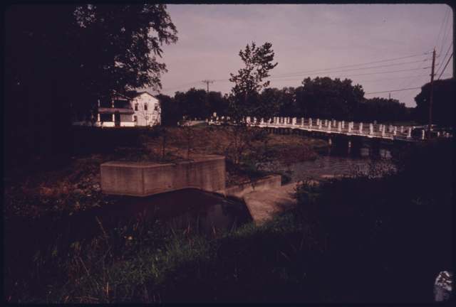
Photo: Frank John Aleksandrowicz, US Environmental Protection Agency, via National Archives, public domain · Wikimedia Commons
Local history sources: en.wikipedia.org · case.edu · en.wikipedia.org · en.wikipedia.org · case.edu · commons.wikimedia.org
Historic places
9 places in Valley View on the National Register of Historic Places. Press a pin or a name for its whole record.
-
Frazee, Stephen, HouseBuilding · Valley View · listed 1976
- Address
- 7733 Canal Rd.
- Where
- Valley View, Cuyahoga County · ZIP 44125
- What it is
- Building
- Listed on the National Register
- 1976
- NRIS reference number
- 76000211
- Coordinates
- 41.35295, -81.59264
National Register file (NPS) ↗ Search Wikipedia ↗ Street map and directions ↗ On the Cracked Buckeye map
-
Gleason, Edmund, HouseBuilding · Valley View · listed 1978
- Address
- 7243 Canal Rd.
- Where
- Valley View, Cuyahoga County · ZIP 44125
- What it is
- Building
- Listed on the National Register
- 1978
- NRIS reference number
- 78000377
- Coordinates
- 41.36736, -81.61035
National Register file (NPS) ↗ Search Wikipedia ↗ Street map and directions ↗ On the Cracked Buckeye map
-
Knapp, William, HouseBuilding · Valley View · listed 1979
- Address
- 7101 Canal Rd.
- Where
- Valley View, Cuyahoga County · ZIP 44125
- What it is
- Building
- Listed on the National Register
- 1979
- NRIS reference number
- 79000289
- Coordinates
- 41.37240, -81.61160
National Register file (NPS) ↗ Search Wikipedia ↗ Street map and directions ↗ On the Cracked Buckeye map
-
Lock No. 37 and SpillwayStructure · Valley View · listed 1979
- Address
- Fitzwater Rd.
- Where
- Valley View, Cuyahoga County · ZIP 44125
- What it is
- Structure
- Listed on the National Register
- 1979
- NRIS reference number
- 79000290
- Coordinates
- 41.35680, -81.59710
National Register file (NPS) ↗ Search Wikipedia ↗ Street map and directions ↗ On the Cracked Buckeye map
-
Lock No. 39 and SpillwayStructure · Valley View · listed 1979
- Address
- Canal Rd.
- Where
- Valley View, Cuyahoga County · ZIP 44125
- What it is
- Structure
- Listed on the National Register
- 1979
- NRIS reference number
- 79000292
- Coordinates
- 41.39039, -81.62492
National Register file (NPS) ↗ Search Wikipedia ↗ Street map and directions ↗ On the Cracked Buckeye map
-
Lock Tender's House and InnBuilding · Valley View · listed 1979
- Address
- 7104 Canal Rd.
- Where
- Valley View, Cuyahoga County · ZIP 44125
- What it is
- Building
- Listed on the National Register
- 1979
- NRIS reference number
- 79000293
- Coordinates
- 41.37248, -81.61303
National Register file (NPS) ↗ Search Wikipedia ↗ Street map and directions ↗ On the Cracked Buckeye map
-
Tinkers Creek AqueductStructure · Valley View · listed 1979
- Address
- Tinkers Creek
- Where
- Valley View, Cuyahoga County · ZIP 44125
- What it is
- Structure
- Listed on the National Register
- 1979
- NRIS reference number
- 79000296
- Coordinates
- 41.36475, -81.60889
National Register file (NPS) ↗ Search Wikipedia ↗ Street map and directions ↗ On the Cracked Buckeye map
-
Ulyatt, Abraham, HouseBuilding · Valley View · listed 1979
- Address
- 6579 Canal Rd.
- Where
- Valley View, Cuyahoga County · ZIP 44125
- What it is
- Building
- Listed on the National Register
- 1979
- NRIS reference number
- 79000297
- Coordinates
- 41.38605, -81.61962
National Register file (NPS) ↗ Search Wikipedia ↗ Street map and directions ↗ On the Cracked Buckeye map
-
Wilson Feed MillBuilding · Valley View · listed 1979
- Address
- 7604 Canal Rd.
- Where
- Valley View, Cuyahoga County · ZIP 44125
- What it is
- Building
- Listed on the National Register
- 1979
- NRIS reference number
- 79000298
- Coordinates
- 41.35626, -81.59638
National Register file (NPS) ↗ Search Wikipedia ↗ Street map and directions ↗ On the Cracked Buckeye map
Source: National Park Service, National Register of Historic Places point file. The listing year is shown where NPS's certification date agrees with the listing's reference number. Listing recognizes significance; it does not restrict a private owner.
Water
The Five Mile Crib, a small structure about 5 miles out in Lake Erie north of Cleveland's Edgewater Park The water here
- Cleveland Public Water System100% of residentsLake Erie
Hospitals, fire stations and more
Inside Valley View's boundary: 1 dialysis center, 1 nursing home, 1 fire or EMS station, 1 college, 4 poor-rated bridges, 9 Toxics Release Inventory facilities and 9 spill cases. Press a pin or a name for its whole record and its source.
Dialysis centers (1)
-
Dialyze Direct Beachwood, OhDialysis · Valley View
- Address
- 9555 Rockside Road, Valley View, OH 44125
- Dialysis stations
- 0
- Medicare star rating
- not rated
- Services
- home hemodialysis training
- Ownership
- for profit
- Chain
- Other
- Medicare certified since
- 2016-07-25
- Phone
- (440) 229-2226
- Medicare ID
- 362842
Medicare Care Compare ↗ CMS dialysis facility list (source) ↗ Street map and directions ↗
Source: CMS dialysis facility list, September 2026, geocoded with the Census Bureau batch geocoder (an address it could not place sits at its ZIP center).
Nursing homes (1)
-
Snf-The Villa at Marymount2 of 5 stars · Garfield Heights
- Address
- 5200 Marymount Village Drive, Garfield Heights, OH 44125
- Certified beds
- 130
- Residents on an average day
- 105
- Medicare overall rating
- 2 of 5 stars
- Health inspections
- 2 of 5 stars
- Staffing
- 2 of 5 stars
- Quality measures
- 4 of 5 stars
- Penalties since 2023
- 2 fines totalling $83,603, 1 payment denial (latest 2025-03-13)
- Ownership
- For profit - Limited Liability company
- Takes
- Medicare and Medicaid
- Phone
- (216) 332-1100
- Medicare ID
- 366335
- Map point
- the ZIP's center (the address did not geocode)
Medicare Care Compare ↗ CMS nursing home data (source) ↗ Street map and directions ↗
Source: CMS Care Compare nursing home provider and penalties files; Medicare star ratings run 1 to 5.
Fire and EMS stations (1)
-
Valley View Fire DepartmentValley View
- Address
- 6895 Hathaway Road, Valley View, OH 44125
- Coordinates
- 41.37865, -81.61014
USGS National Map structures (source) ↗ Street map and directions ↗
Source: USGS National Map structures (most Ohio records last updated 2019 to 2022), checked against the Columbus and Cleveland station lists. The department that answers a call is set by jurisdiction and mutual aid, not by distance.
Colleges (1)
-
Ohio Media School-Valley ViewFor-profit career school · Valley View
- What it is
- For-profit career school
- City
- Valley View
- Students, 2023-24 (12-month count)
- 260
- IPEDS unit ID
- 410797
College Navigator (NCES) ↗ IPEDS data (source) ↗ Street map and directions ↗
Source: NCES IPEDS 2024 directory, 2023-24 enrollment and tuition, graduation rates for the 2017 (four-year) and 2020 (two-year) entering classes.
Bridges rated poor (4)
-
Fosdick Road over Ohio CanalPoor · built 1965
- Condition
- Poor: a deck, superstructure, substructure or culvert rated 4 or below on the 0 to 9 scale
- What it is
- Bridge
- Built
- 1965
- Length
- 25 ft
- Owner
- City
- Vehicles a day
- 9,331
- Coordinates
- 41.40411, -81.62709
National Bridge Inventory (source) ↗ Street map and directions ↗
-
Pl Valley Rd Cr121 over Canal Rd Oh Canal/metroPoor · built 1958
- Condition
- Poor: a deck, superstructure, substructure or culvert rated 4 or below on the 0 to 9 scale
- What it is
- Bridge
- Built
- 1958
- Length
- 194 ft
- Owner
- County
- Vehicles a day
- 14,182
- Coordinates
- 41.35939, -81.59868
National Bridge Inventory (source) ↗ Street map and directions ↗
-
Riverview Rd Cr 96 over Ohio CanalPoor · built 1954
- Condition
- Poor: a deck, superstructure, substructure or culvert rated 4 or below on the 0 to 9 scale
- What it is
- Bridge
- Built
- 1954
- Length
- 18 ft
- Owner
- County
- Vehicles a day
- 7,497
- Coordinates
- 41.36675, -81.61088
National Bridge Inventory (source) ↗ Street map and directions ↗
-
Stone Road Cr 153 over Ohio CanalPoor · built 1950
- Condition
- Poor: a deck, superstructure, substructure or culvert rated 4 or below on the 0 to 9 scale
- What it is
- Bridge
- Built
- 1950
- Length
- 17 ft
- Owner
- County
- Vehicles a day
- 300
- Coordinates
- 41.38518, -81.61979
National Bridge Inventory (source) ↗ Street map and directions ↗
Source: FHWA National Bridge Inventory 2025. "Poor" means one major part rated 4 or below on the 0 to 9 scale; it calls for repair, not closing, unless the state posts or closes the bridge.
Facilities reporting toxic releases (9)
-
Amazon.Com Services Llc - Cak4Toxics Release Inventory · Valley View
- Address
- 5585 Canal Rd, Valley View, OH 44125
- County
- Cuyahoga County
- Status
- Reports to the Toxics Release Inventory (***unchanged***)
- EPA program ID
- 4412WMZNCM5585C
- EPA registry ID
- 110071261905
EPA facility record ↗ EPA Facility Registry Service (source) ↗ Street map and directions ↗
-
Asco Power Technologies Inc Cleveland HalleToxics Release Inventory · Valley View
- Address
- 6255 Halle Drive, Valley View, OH 44125
- County
- Cuyahoga County
- Status
- Reports to the Toxics Release Inventory (active)
- EPA program ID
- 44125ZLMNF6255H
- EPA registry ID
- 110000387457
EPA facility record ↗ EPA Facility Registry Service (source) ↗ Street map and directions ↗
-
Avtron Power SolutionsToxics Release Inventory · Cleveland
- Address
- 9450 Allen Dr, Cleveland, OH 44125
- County
- Cuyahoga County County
- Status
- Reports to the Toxics Release Inventory (***unchanged***)
- EPA program ID
- 4412WVTRNP945AL
- EPA registry ID
- 110071730924
EPA facility record ↗ EPA Facility Registry Service (source) ↗ Street map and directions ↗
-
Evergreen ResourcesToxics Release Inventory · Cleveland
- Address
- 6250 Halle Dr, Cleveland, OH 44125
- County
- Cuyahoga County County
- Status
- Reports to the Toxics Release Inventory
- EPA program ID
- 4412WVRGRN625HA
- EPA registry ID
- 110069611664
EPA facility record ↗ EPA Facility Registry Service (source) ↗ Street map and directions ↗
-
Kendale Industries IncToxics Release Inventory · Valley View
- Address
- 7600 Hub Pky., Valley View, OH 44125
- County
- Cuyahoga County
- Status
- Reports to the Toxics Release Inventory (active)
- EPA program ID
- 44125KNDLN7600H
- EPA registry ID
- 110000387395
EPA facility record ↗ EPA Facility Registry Service (source) ↗ Street map and directions ↗
-
Sherwood Valve, LlcToxics Release Inventory · Valley View
- Address
- 7900 Hub Park Way, Valley View, OH 44102
- County
- Cuyahoga County
- Status
- Reports to the Toxics Release Inventory (active)
- EPA program ID
- 4410WSHRWD79HUB
- EPA registry ID
- 110067123311
EPA facility record ↗ EPA Facility Registry Service (source) ↗ Street map and directions ↗
-
The Blaster Chemical CompaniesToxics Release Inventory · Valley View
- Address
- 8500 Sweet Valley Dr, Valley View, OH 44125
- County
- Cuyahoga County
- Status
- Reports to the Toxics Release Inventory (***unchanged***)
- EPA program ID
- 4412WTHBLS85SWE
- EPA registry ID
- 110004735779
EPA facility record ↗ EPA Facility Registry Service (source) ↗ Street map and directions ↗
-
Triangle Machine Products CoToxics Release Inventory · Cleveland
- Address
- 6055 Hillcrest Dr, Cleveland, OH 44125
- County
- Cuyahoga County County
- Status
- Reports to the Toxics Release Inventory
- EPA program ID
- 4412WTRNGL655HI
- EPA registry ID
- 110070071268
EPA facility record ↗ EPA Facility Registry Service (source) ↗ Street map and directions ↗
-
Tyler Elevator ProductsToxics Release Inventory · Valley View
- Address
- 6161 Halle Dr, Valley View, OH 44125
- County
- Cuyahoga County
- Status
- Reports to the Toxics Release Inventory (active)
- EPA program ID
- 44125TYLRL6161H
- EPA registry ID
- 110004696721
EPA facility record ↗ EPA Facility Registry Service (source) ↗ Street map and directions ↗
Source: EPA Facility Registry Service, Toxics Release Inventory reporters. Reporting a release is required of large users of listed chemicals; it is not by itself a violation.
Spills reported since 2021 (9)
-
Oil Hydraulic Fluid(S)2025-08-10 · Valley View
- Reported
- 2025-08-10
- What spilled
- Oil Hydraulic Fluid(S)
- Where
- Valley View, Cuyahoga County
- Ohio EPA district office
- NEDO
- Ohio EPA case number
- 2508EPA0001347
Ohio EPA spill reports (source) ↗ Street map and directions ↗
-
Oil Petroleum Not Otherwise Specified (Nos)2025-02-21 · Valley View
- Reported
- 2025-02-21
- What spilled
- Oil Petroleum Not Otherwise Specified (Nos)
- Where
- Valley View, Cuyahoga County
- Ohio EPA district office
- NEDO
- Ohio EPA case number
- 2502EPA0000236
Ohio EPA spill reports (source) ↗ Street map and directions ↗
-
Sheen Rainbow / Hydrocarbon2024-08-14 · Valley View
- Reported
- 2024-08-14
- What spilled
- Sheen Rainbow / Hydrocarbon
- Where
- Valley View, Cuyahoga County
- Ohio EPA district office
- NEDO
- Ohio EPA case number
- 2408EPA0001406
Ohio EPA spill reports (source) ↗ Street map and directions ↗
-
Fuel Diesel / Diesel Fuel (Vehicle On Or Off Road)2024-05-22 · Valley View
- Reported
- 2024-05-22
- What spilled
- Fuel Diesel / Diesel Fuel (Vehicle On Or Off Road)
- Where
- Valley View, Cuyahoga County
- Ohio EPA district office
- NEDO
- Ohio EPA case number
- 2405EPA0000857
Ohio EPA spill reports (source) ↗ Street map and directions ↗
-
Contaminated Water Reached water2024-03-26 · Valley View
- Reported
- 2024-03-26
- What spilled
- Contaminated Water
- Reached a waterway
- 99 - Unnamed
- Where
- Valley View, Cuyahoga County
- Ohio EPA district office
- NEDO
- Ohio EPA case number
- 2403EPA0000467
Ohio EPA spill reports (source) ↗ Street map and directions ↗
-
Oil Crude2023-12-16 · Valley View
- Reported
- 2023-12-16
- What spilled
- Oil Crude
- Where
- Valley View, Cuyahoga County
- Ohio EPA district office
- NEDO
- Ohio EPA case number
- 2312EPA0002059
Ohio EPA spill reports (source) ↗ Street map and directions ↗
-
Fish Kill Reached water2022-08-28 · Valley View
- Reported
- 2022-08-28
- What spilled
- Fish Kill
- Reached a waterway
- 99 - Unnamed
- Where
- Valley View, Cuyahoga County
- Ohio EPA district office
- NEDO
- Ohio EPA case number
- 2208EPA0001328
Ohio EPA spill reports (source) ↗ Street map and directions ↗
-
Fuel Diesel / Diesel Fuel (Vehicle On Or Off Road) Reached water2022-03-31 · Valley View
- Reported
- 2022-03-31
- What spilled
- Fuel Diesel / Diesel Fuel (Vehicle On Or Off Road); Oil Hydraulic Fluid(S)
- Largest amount reported
- 3 gallons
- Reached a waterway
- 99 - Unnamed
- Where
- Valley View, Cuyahoga County
- Ohio EPA district office
- NEDO
- Ohio EPA case number
- 2203EPA0000439
Ohio EPA spill reports (source) ↗ Street map and directions ↗
-
Antifreeze Vehicle Cooling2026-03-17 · Valley View
- Reported
- 2026-03-17
- What spilled
- Antifreeze Vehicle Cooling
- Where
- Valley View, Cuyahoga County
- Ohio EPA district office
- NEDO
- Ohio EPA case number
- 2603EPA0000423
Ohio EPA spill reports (source) ↗ Street map and directions ↗
Source: Ohio EPA emergency response spill reports, 2021 to September 2026, one point per case where Ohio EPA placed it. A report is what the caller or responder recorded; amounts are often blank or estimated.
Its ZIP codes
Each ZIP code that touches Valley View, with the share of its residents who live here and the same headline figures as the ZIP page.
| ZIP | Share | Water | Radon | Home value | Schools | Flood |
|---|---|---|---|---|---|---|
| 44125 Garfield Heights and Cleveland | 6% | The Five Mile Crib, a small structure about 5 miles out in Lake Erie north of Cleveland's Edgewater Park | 2.0 pCi/L average radon | Median year built 1952 | Garfield Heights City · 2.5 stars overall | 1.2% of residents in the 1% floodplain |
Local government
The state auditor's record.
Auditor of State record
- No fiscal caution, watch or emergency on the Auditor of State's lists.
- Financial Audit, 2025, released 2026-09-15
- Financial Audit, 2024, released 2025-12-30
On the November 3, 2026 ballot
Statewide question: State Issue 3: Voter ID
Local questions for Valley View, Cuyahoga County and its school district:
- Garfield Heights City School District: Renews a 7.74-mill property tax levy for the current operating expenses of Garfield Heights City School District for 5 years, beginning in 2027.
- Cuyahoga County: Miscellaneous, for Charter Amendment: Article II, Section 2.03 & Article VI, Section 6.04.
- Cuyahoga County: Miscellaneous, for Charter Amendment: Article XII, Section 12.09.
- Cuyahoga County: Miscellaneous, for Charter Amendment: Article V, Section 5.06.
- Cuyahoga County: Authorizes an additional 2.25-mill property tax levy to acquire, construct, renovate, finance, maintain & operate developmental disabilities facilities of Cuyahoga County for 10 years, beginning in 2026.
- Cuyahoga County: Renews and increases a 7.2-mill property tax levy for the general fund, health & human social services of Cuyahoga County for 10 years, beginning in 2026.
Races, candidates and every question for an address: your ballot. County offices and judges are on your county board's sample ballot.
The county
Cuyahoga County: 52 ZIP codes, 59 cities, villages and townships with pages here, 1,232,925 people (Census Bureau estimate, July 2025).
Nearby places
Rain and snow
How much has actually fallen on Valley View, day by day, from 1871 to now. Daily totals, not averages.
- rain, last 30 days
- 1.96 in
- 2026-10-01 to 2026-10-30
- rain so far in 2026
- 34.5 in
- about normal for the date
- snow so far in 2026
- 43.9 in
- a normal year brings 67.7 in
- a normal year
- 40.6 in
- average of 30 years, 1991-2020
| Month | Rain (in) | Snow (in) | Days counted |
|---|---|---|---|
| October 2026 | 1.96 | — | 30 |
| September 2026 | 2.85 | — | 30 |
| August 2026 | 6.70 | — | 31 |
| July 2026 | 2.88 | — | 31 |
| June 2026 | 2.96 | — | 30 |
| May 2026 | 4.13 | — | 31 |
| April 2026 | 6.32 | 0.1 | 30 |
| March 2026 | 3.52 | 1.8 | 31 |
| February 2026 | 0.78 | 8.6 | 28 |
| January 2026 | 2.41 | 33.4 | 31 |
| December 2025 | 2.74 | 16.1 | 31 |
| November 2025 | 2.32 | 9.0 | 30 |
| Driest year (estimated) | 1963 — 18.7 in |
|---|---|
| Snowiest year (estimated) | 2005 — 108.5 in |
| Wettest day (estimated) | 7 September 1996 — 4.59 in |
| Heaviest snowfall in a day (estimated) | 10 November 1913 — 14.21 in |
| Deepest snow on the ground (estimated) | 24 February 1993 — 20.98 in |
Estimated, not measured. No rain gauge has ever stood inside Valley View, so every figure here is worked out from the gauges around it - the nearest ones weighted most. Treat them as close estimates rather than readings.
56,916 days of records, 1871-01-01 to 2026-10-30. Source: NOAA NCEI GHCN-Daily, 3,240 gauges in and around Ohio. A day is "gauged" when a gauge standing inside the boundary reported it, and the value is the mean of those gauges. Otherwise it is interpolated by inverse distance from every gauge reporting within 50 miles. Nothing is carried forward, back-filled or smoothed. Against NOAA nClimDiv county monthly precipitation over 136,848 complete county-months (checked 2026-11-01): correlation 0.9515, median absolute difference 0.217 in a month. Built 2026-11-01 from the Cracked Buckeye precipitation archive. Snow is the softer number — snowfall is measured by hand with a ruler, no agency publishes a gridded county snowfall series, and blowing snow defeats every observer.
Environmental permits and filings
What Ohio EPA has on file for Valley View: permits, inspections, violations, cleanups and the state loans behind sewer and water work. Every line links to the agency's own document.
- facilities and sites on file
- 68
- those placed on the map inside Valley View
| Program | Facilities and sites |
|---|---|
| Hazardous waste | 24 |
| Air pollution | 20 |
| Voluntary cleanup | 11 |
| Composting | 4 |
| Wastewater and stormwater discharge | 3 |
| Contaminated-site cleanup | 2 |
| Wetland and stream fill | 2 |
| Construction-debris landfills | 1 |
| Sewer and water-line construction | 1 |
Source: Ohio EPA eDocument portal (edocpub.epa.ohio.gov), indexed 2026-10-14. Facilities are placed on the map from Ohio EPA's own map layers, EPA's Facility Registry, coordinates written in the filings, or a geocoded street address. A permit filed under a private person's name (most are household septic systems) is counted but never named, placed or linked; licenses for individual workers and open-burning notices are left out entirely.
Quick answers
What county is Valley View, Ohio in?
Valley View is a village in Cuyahoga County, Ohio, with 1,897 residents.
When was Valley View, Ohio founded?
Valley View was incorporated 1919, splitting from Independence Township after a dispute over school locations. Source
How did Valley View, Ohio get its name?
The village's name refers directly to the Cuyahoga River valley it sits within. Source
What ZIP code is Valley View, Ohio?
Most of Valley View is in ZIP code 44125.
Where does Valley View, Ohio get its water?
The main water source for Valley View (Cleveland Public Water System): The Five Mile Crib, a small structure about 5 miles out in Lake Erie north of Cleveland's Edgewater Park.
Cite this page
Cite this page as:
Cracked Buckeye, "Valley View, Cuyahoga County", https://crackedbuckeye.com/place/valley-view/, built 2026-10-31, accessed [date].
How to cite · Report a correction · Built 2026-10-31