Local events in Trimble Township, Athens County
Nothing is posted for Trimble Township itself yet; here is what is on within 20 miles. All local events in Trimble Township, Athens County
Know a calendar we should watch? Send the link
Checked October 20; the events page is refreshed daily.
How Trimble Township, Athens County began
Trimble Township sits at the extreme northern edge of Athens County, the only township in the county that borders Perry County, and was organized in April 1827 out of Ames Township, named for Ohio governor Allen Trimble. Its first white settlers, Solomon Tuttle Sr. and his son and brother, arrived from Vermont in 1802 along Sunday Creek, which runs the length of the township and gave its name to the coal seam that later defined the area. Three villages grew along the creek during the coal boom — Glouster (covered separately), Trimble (originally platted as Oxford), and Jacksonville, laid out in 1879 by Oliver D. Jackson — all of which peaked in population between 1910 and 1920 and have declined steadily since the mines closed. The lower reaches of Sunday Creek remain scarred by acid mine drainage from that era.
Settled 1802, by Solomon Tuttle Sr. with his son Cyrus and brother Nial, from Vermont, incorporated organized as a township in April 1827, separated from Ames Township.
Where the name comes from
Named for Allen Trimble, Governor of Ohio; it is the only Trimble Township in the state.
Before the town
No Native American sites, trails, or villages specific to Trimble Township have been found in the sources searched. The 1881-83 Athens County history records the Shawnee as occupying the broader Athens County region, and documents Adena/Hopewell-era mounds and an ancient earthwork on 'the Plains' in Athens and Dover townships — both south of Trimble Township and not evidence of a Trimble Township presence. Nothing site-specific to Trimble Township, Glouster, Trimble village, or Jacksonville was located. The county-wide record includes the Wyandot, Shawnee, Mingo, and Delaware presence and the treaty cessions covering the county.
Nations recorded here: Shawnee.
Timeline
- — Solomon Tuttle Sr., his son Cyrus Tuttle, and his brother Nial Tuttle, all from Vermont, become the township's first white settlers, taking up land along Sunday Creek.
- — William Bagley builds the township's first mill, a cloth-dressing factory and flour mill; his son Samuel opens the first tannery around the same time.
- — Jonathan Watkins builds a mill at the settlement of Oxford, later renamed Trimble.
- — Trimble Township is organized in April, separated from Ames Township, and named for Governor Allen Trimble.
- — A post office begins continuous operation at the village of Trimble (formerly Oxford).
- — Jacksonville is laid out by Oliver D. Jackson, for whom it is named, and grows around coal mining and small business on Sunday Creek.
- — Coal shipping begins from mines near Glouster; a 60-acre village is platted there under the name Sedalia (renamed Glouster in 1886).
- — A post office is established at Jacksonville; it continues operating in the present day.
- — Jacksonville records its peak population, 1,285, at the height of the Sunday Creek coal boom.
- — The village of Trimble records its peak population, 806.
- — An Ohio EPA study finds the lowermost thirteen miles of Sunday Creek 'irretrievably damaged to the extent that no appreciable aquatic life can be supported,' a result of acid mine drainage from the valley's abandoned coal mines.
Stories
Three villages, one creek, one coal seam
Trimble Township's three villages all grew directly out of Sunday Creek's coal. Trimble itself began as Oxford, platted in the early 1800s and renamed for Governor Allen Trimble; its post office has run continuously since 1839. Jacksonville, to the south, was laid out in 1879 by Oliver D. Jackson and grew around the coal mines that lined the creek, its population climbing to 1,285 by 1910 as families walked or rode the rails to nearby shafts. Glouster, to the north, came together fastest of all: platted in 1882 the same month coal shipping began, renamed from Sedalia within four years, and swollen by 1920 to over 3,000 residents. All three peaked between 1910 and 1920 and have been losing population ever since, the common arc of the Hocking Valley coalfield.
What the mines left in the creek
Sunday Creek runs the length of Trimble Township and gave its name to the coal seam that built Glouster, Trimble, and Jacksonville. When the deep mines and strip pits shut down, they left behind exposed sulfide minerals that react with air and water to produce sulfuric acid, and that acid mine drainage has never stopped draining into the creek. By 1997 the Ohio EPA judged the lowest thirteen miles of Sunday Creek 'irretrievably damaged,' too acidic to support fish or the insects fish feed on; the orange-stained creek bed below Glouster is the visible residue of iron oxide precipitating out of the drainage. The nonprofit Rural Action and the Sunday Creek Watershed Group have worked on abatement projects in the watershed since at least 2012, but the lower creek remains one of the most heavily mine-damaged streams in the state.
Photographs
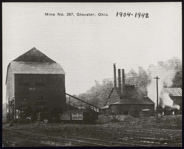
Photo: Wikimedia Commons, Category:Glouster, Ohio, public domain · Wikimedia Commons
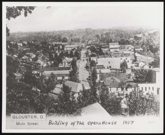
Photo: Wikimedia Commons, Category:Glouster, Ohio, public domain · Wikimedia Commons
Local history sources: genealogytrails.com · en.wikipedia.org · en.wikipedia.org · en.wikipedia.org · en.wikipedia.org · en.wikipedia.org · en.wikipedia.org · en.wikipedia.org · commons.wikimedia.org · archive.org
Historic places
1 place in Trimble Township, Athens County on the National Register of Historic Places. Press a pin or a name for its whole record.
-
Palos Covered BridgeStructure · Glouster · listed 1977
- Address
- 1 mi. N of Gloucester off OH 13
- Where
- Glouster, Athens County · ZIP 45732
- What it is
- Structure
- Listed on the National Register
- 1977
- NRIS reference number
- 77001041
- Coordinates
- 39.52526, -82.07187
National Register file (NPS) ↗ Search Wikipedia ↗ Street map and directions ↗ On the Cracked Buckeye map
Source: National Park Service, National Register of Historic Places point file. The listing year is shown where NPS's certification date agrees with the listing's reference number. Listing recognizes significance; it does not restrict a private owner.
Water
Mostly private wells The water here
- Glouster Public Water System84% of residentsHocking River Buried Valley Aquifer (wells)
- Sunday Creek Valley Water14% of residentsHocking River Buried Valley Aquifer (wells)
- Jacksonville Village1% of residentsHocking River Buried Valley Aquifer (wells)
- Trimble Village1% of residentsHocking River Buried Valley Aquifer (wells)
- Southern Perry Co-irish Ridge0% of residentsHocking River Buried Valley Aquifer (wells)
Hospitals, fire stations and more
Inside Trimble Township, Athens County's boundary: 1 high-hazard dam, 2 public schools, 3 poor-rated bridges and 1 spill case. Press a pin or a name for its whole record and its source.
High-hazard dams (1)
-
Tom Jenkins DamEast Br of Sunday Ck · condition: not available
- Hazard class
- High: a failure would probably cost a life
- Condition
- Not Available
- River or stream
- East Br of Sunday Ck
- Purpose
- Flood Risk Reduction;Recreation;Water Supply
- Type
- Earth
- Height
- 84 ft
- Storage
- 26,900 acre-feet
- Completed
- 1950
- Owner type
- Federal
- County
- Athens County
- Nearest town (NID)
- Glouster
- Last inspection
- 08/14/2025
- Emergency action plan
- Yes
- NID ID
- OH00018
National Inventory of Dams record ↗ National Inventory of Dams (source) ↗ Street map and directions ↗
Source: U.S. Army Corps of Engineers National Inventory of Dams, August 2026. "High hazard" rates what a failure would cost downstream, not how likely one is; the condition is the state's assessment.
Public schools (2)
-
Trimble Elementary School2.5 of 5 stars · Glouster
- Address
- 18500 Jacksonville Rd, Glouster, OH 45732
- School district
- Trimble Local School District
- Kind (NCES)
- Regular School
- Students, 2023-24
- 358
- Teachers (full-time equivalent)
- 28
- Report card, 2025-26
- 2.5 of 5 stars
- Performance index
- 59%
- Ohio building IRN
- 037556
- NCES school ID
- 390459202385
NCES school record ↗ Ohio School Report Card ↗ Street map and directions ↗
-
Trimble Junior High1.5 of 5 stars · Glouster
- Address
- 18500 Jacksonville Rd, Glouster, OH 45732
- School district
- Trimble Local School District
- Kind (NCES)
- Regular School
- Students, 2023-24
- 193
- Teachers (full-time equivalent)
- 18
- Report card, 2025-26
- 1.5 of 5 stars
- Performance index
- 49.3%
- Ohio building IRN
- 065318
- NCES school ID
- 390459202386
NCES school record ↗ Ohio School Report Card ↗ Street map and directions ↗
Source: NCES EDGE public school locations 2024-25 and Common Core of Data 2023-24 (type, students, teachers); Ohio School Report Cards 2025-26 (Department of Education and Workforce), matched by name within the district.
Bridges rated poor (3)
-
T1259 over Sunday Crk (congress RunPoor · built 1951
- Condition
- Poor: a deck, superstructure, substructure or culvert rated 4 or below on the 0 to 9 scale
- What it is
- Bridge
- Built
- 1951
- Length
- 8 ft
- Owner
- County
- Vehicles a day
- 324
- Coordinates
- 39.49923, -82.05559
National Bridge Inventory (source) ↗ Street map and directions ↗
-
T304 over Tribute To Tylor RunPoor · built 1982
- Condition
- Poor: a deck, superstructure, substructure or culvert rated 4 or below on the 0 to 9 scale
- What it is
- Bridge
- Built
- 1982
- Length
- 9 ft
- Owner
- County
- Vehicles a day
- 40
- Coordinates
- 39.49955, -82.14942
National Bridge Inventory (source) ↗ Street map and directions ↗
-
TR 315 over West Brch Sunday CreekPoor · built 1975
- Condition
- Poor: a deck, superstructure, substructure or culvert rated 4 or below on the 0 to 9 scale
- What it is
- Bridge
- Built
- 1975
- Length
- 20 ft
- Owner
- County
- Vehicles a day
- 365
- Coordinates
- 39.51887, -82.08636
National Bridge Inventory (source) ↗ Street map and directions ↗
Source: FHWA National Bridge Inventory 2025. "Poor" means one major part rated 4 or below on the 0 to 9 scale; it calls for repair, not closing, unless the state posts or closes the bridge.
Spills reported since 2021 (1)
-
Fish Kill Reached water2021-07-23 · Trimble Twp
- Reported
- 2021-07-23
- What spilled
- Fish Kill
- Reached a waterway
- 99 - Unnamed
- Where
- Trimble Twp, Athens County
- Ohio EPA district office
- SEDO
- Ohio EPA case number
- 2107EPA0001116
Ohio EPA spill reports (source) ↗ Street map and directions ↗
Source: Ohio EPA emergency response spill reports, 2021 to September 2026, one point per case where Ohio EPA placed it. A report is what the caller or responder recorded; amounts are often blank or estimated.
Its ZIP codes
Each ZIP code that touches Trimble Township, Athens County, with the share of its residents who live here and the same headline figures as the ZIP page.
| ZIP | Share | Water | Radon | Home value | Schools | Flood |
|---|---|---|---|---|---|---|
| 45732 Glouster | 36% | Mostly private wells | Too few radon tests | Median year built 1950 | Trimble Local · 2 stars overall | 11% of residents in the 1% floodplain |
| 45740 Jacksonville | 2% | Six wells (4 MGD combined) in a sand-and-gravel aquifer in the Hocking River Buried Valley aquifer system, Dover Township, Athens County (2025 CCR). Ohio EPA's May 2012 source water assessment rates the source highly susceptible to contamination (thin clay cover, aquifer less than 20 ft deep). | Too few radon tests | Median year built 1900 | Trimble Local · 2 stars overall | 35% of residents in the 1% floodplain |
Local government
Who holds office in Trimble Township, Athens County, how its elections and ballot issues came out, and the state auditor's record.
Money issues on the ballot since 2020: 3 of 3 passed.
Ballot issues
| Date | Issue | For | Against | Result |
|---|---|---|---|---|
| 2026-05-05 | 8: #8 Trimble Township Tax Levy Fire | 123 | 70 | Passed (63.73% for), unofficial |
| 2024-11-05 | 13: 13 Trimble Township Tax Levy Fire | 427 | 327 | Passed (56.63% for) |
| 2020-11-03 | 19: 19 Trimble Twp Tax Levy Fire | 456 | 280 | Passed (61.96% for), unofficial |
Elections for office
| Date | Office | Candidates and votes |
|---|---|---|
| 2021-11-02 | Township Trustee (unofficial count) | Paul Smoke Barrett 461, 40.37%; Samuel Kamento 367, 32.14%; Kevin Moore 314, 27.5% |
Winners in bold. Results from the county board of elections' official canvass unless marked.
Auditor of State record
- No fiscal caution, watch or emergency on the Auditor of State's lists.
- Agreed Upon Procedures, 2023 to 2024, released 2025-07-10
The county
Athens County: 16 ZIP codes, 29 cities, villages and townships, 67,237 people.
Nearby places
Quick answers
What county is Trimble Township, Ohio in?
Trimble Township, Athens County is a township in Athens County, Ohio, with 1,650 residents.
When was Trimble Township, Ohio founded?
Trimble Township, Athens County was settled 1802, by Solomon Tuttle Sr. with his son Cyrus and brother Nial, from Vermont; incorporated organized as a township in April 1827, separated from Ames Township. Source
How did Trimble Township, Ohio get its name?
Named for Allen Trimble, Governor of Ohio; it is the only Trimble Township in the state. Source
What ZIP code is Trimble Township, Ohio?
Most of Trimble Township, Athens County is in ZIP code 45732.
Where does Trimble Township, Ohio get its water?
The main water source for Trimble Township, Athens County (Glouster Public Water System): Mostly private wells.
Cite this page
Cite this page as:
Cracked Buckeye, "Trimble Township, Athens County", https://crackedbuckeye.com/place/trimble-township-athens-county/, built 2026-10-31, accessed [date].
How to cite · Report a correction · Built 2026-10-31
